Container: cardboard, glued; maps, paper on canvas, lithography; 54,2 × 54,5 cm; scale: 1:25,000;
Received from the 16th Imperial and Royal Varaždin Infantry Regiment
HPM/PMH-3977
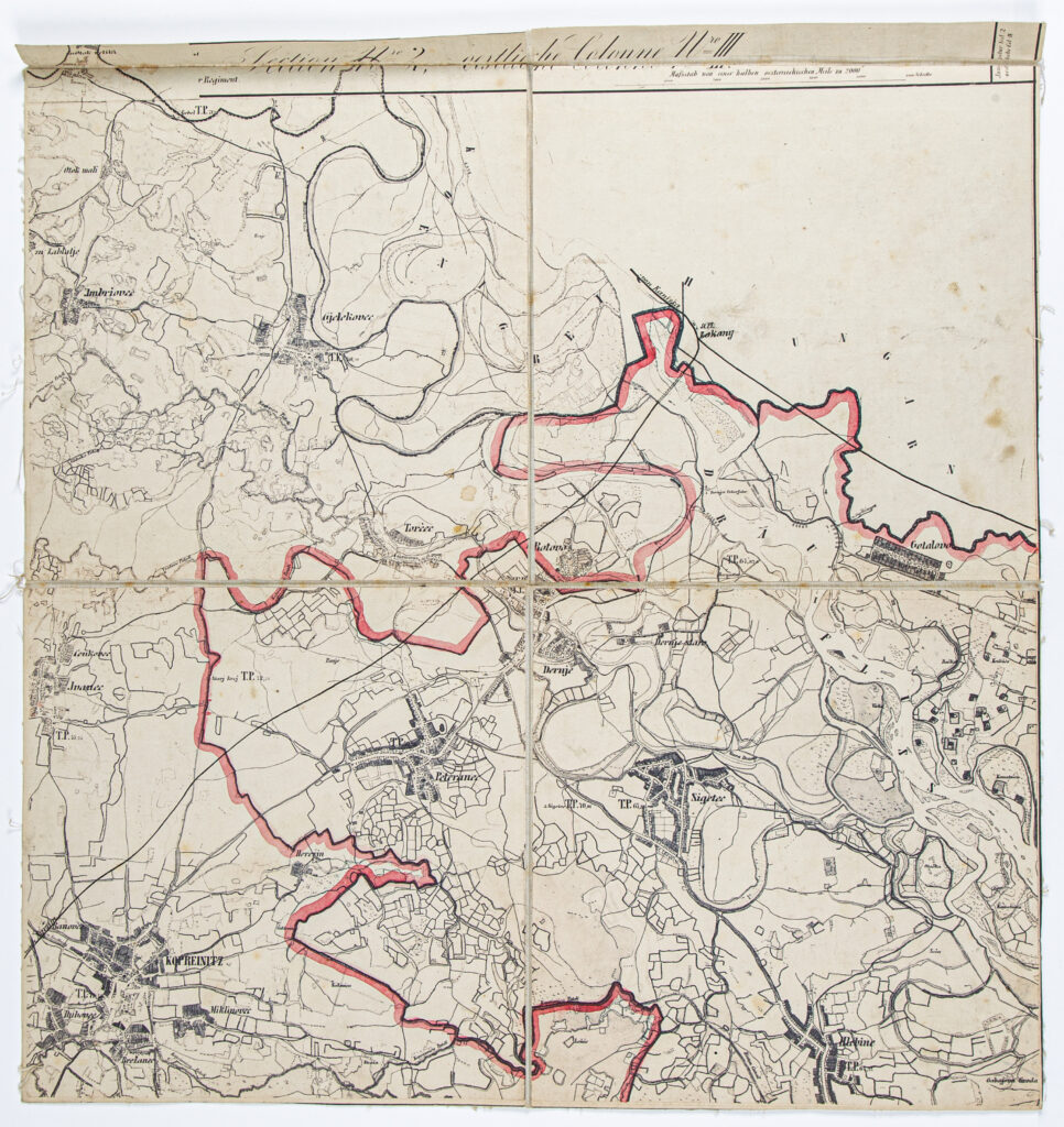
Detailed map of the Bjelovar-Križevci County comprising 16 sheets with marked county borders and toponyms of surrounding settlements, and with visible infrastructure network. The Bjelovar County, with its seat in Bjelovar, was established on the territory of the former Varaždin Generalate, which was abolished in 1871 and integrated into civilian Croatia. In 1886, the ‘Law on the Organisation of Counties and Districts and the Prescription of a New Administrative-Territorial Organisation of Counties Divided into Districts’ united the Križevci and Bjelovar Counties into the Bjelovar-Križevci County, which encompassed the towns of Bjelovar, Križevci, and Ivanić. However, several months later, the ‘Order by which the Number and Territorial Extent of Administrative Districts and Seats of District Governments in the Kingdoms of Croatia and Slavonia are Determined’ was adopted. It defined the following: the Bjelovar-Križevci County is divided into seven districts (Bjelovar, Đurđevac, Koprivnica, Grubišno Polje, Garešnica, Križ, and Križevci); along with the towns Bjelovar, Križevci, and Ivanić, the county also includes Koprivnica, while the municipalities Kutina and Popovača are annexed to the Križ district, which is also evidenced by the moving of the southern border of the Bjelovar-Križevci County to the river Ilova, i.e. Lonja, which is visible on the map itself.

Detailed map of the Bjelovar-Križevci County comprising 16 sheets with marked county borders and toponyms of surrounding settlements, and with visible infrastructure network. The Bjelovar County, with its seat in Bjelovar, was established on the territory of the former Varaždin Generalate, which was abolished in 1871 and integrated into civilian Croatia. In 1886, the ‘Law on the Organisation of Counties and Districts and the Prescription of a New Administrative-Territorial Organisation of Counties Divided into Districts’ united the Križevci and Bjelovar Counties into the Bjelovar-Križevci County, which encompassed the towns of Bjelovar, Križevci, and Ivanić. However, several months later, the ‘Order by which the Number and Territorial Extent of Administrative Districts and Seats of District Governments in the Kingdoms of Croatia and Slavonia are Determined’ was adopted. It defined the following: the Bjelovar-Križevci County is divided into seven districts (Bjelovar, Đurđevac, Koprivnica, Grubišno Polje, Garešnica, Križ, and Križevci); along with the towns Bjelovar, Križevci, and Ivanić, the county also includes Koprivnica, while the municipalities Kutina and Popovača are annexed to the Križ district, which is also evidenced by the moving of the southern border of the Bjelovar-Križevci County to the river Ilova, i.e. Lonja, which is visible on the map itself.
Detailed map of the Bjelovar-Križevci County comprising 16 sheets with marked county borders and toponyms of surrounding settlements, and with visible infrastructure network. The Bjelovar County, with its seat in Bjelovar, was established on the territory of the former Varaždin Generalate, which was abolished in 1871 and integrated into civilian Croatia. In 1886, the ‘Law on the Organisation of Counties and Districts and the Prescription of a New Administrative-Territorial Organisation of Counties Divided into Districts’ united the Križevci and Bjelovar Counties into the Bjelovar-Križevci County, which encompassed the towns of Bjelovar, Križevci, and Ivanić. However, several months later, the ‘Order by which the Number and Territorial Extent of Administrative Districts and Seats of District Governments in the Kingdoms of Croatia and Slavonia are Determined’ was adopted. It defined the following: the Bjelovar-Križevci County is divided into seven districts (Bjelovar, Đurđevac, Koprivnica, Grubišno Polje, Garešnica, Križ, and Križevci); along with the towns Bjelovar, Križevci, and Ivanić, the county also includes Koprivnica, while the municipalities Kutina and Popovača are annexed to the Križ district, which is also evidenced by the moving of the southern border of the Bjelovar-Križevci County to the river Ilova, i.e. Lonja, which is visible on the map itself.
Detailed map of the Bjelovar-Križevci County comprising 16 sheets with marked county borders and toponyms of surrounding settlements, and with visible infrastructure network. The Bjelovar County, with its seat in Bjelovar, was established on the territory of the former Varaždin Generalate, which was abolished in 1871 and integrated into civilian Croatia. In 1886, the ‘Law on the Organisation of Counties and Districts and the Prescription of a New Administrative-Territorial Organisation of Counties Divided into Districts’ united the Križevci and Bjelovar Counties into the Bjelovar-Križevci County, which encompassed the towns of Bjelovar, Križevci, and Ivanić. However, several months later, the ‘Order by which the Number and Territorial Extent of Administrative Districts and Seats of District Governments in the Kingdoms of Croatia and Slavonia are Determined’ was adopted. It defined the following: the Bjelovar-Križevci County is divided into seven districts (Bjelovar, Đurđevac, Koprivnica, Grubišno Polje, Garešnica, Križ, and Križevci); along with the towns Bjelovar, Križevci, and Ivanić, the county also includes Koprivnica, while the municipalities Kutina and Popovača are annexed to the Križ district, which is also evidenced by the moving of the southern border of the Bjelovar-Križevci County to the river Ilova, i.e. Lonja, which is visible on the map itself.
Detailed map of the Bjelovar-Križevci County comprising 16 sheets with marked county borders and toponyms of surrounding settlements, and with visible infrastructure network. The Bjelovar County, with its seat in Bjelovar, was established on the territory of the former Varaždin Generalate, which was abolished in 1871 and integrated into civilian Croatia. In 1886, the ‘Law on the Organisation of Counties and Districts and the Prescription of a New Administrative-Territorial Organisation of Counties Divided into Districts’ united the Križevci and Bjelovar Counties into the Bjelovar-Križevci County, which encompassed the towns of Bjelovar, Križevci, and Ivanić. However, several months later, the ‘Order by which the Number and Territorial Extent of Administrative Districts and Seats of District Governments in the Kingdoms of Croatia and Slavonia are Determined’ was adopted. It defined the following: the Bjelovar-Križevci County is divided into seven districts (Bjelovar, Đurđevac, Koprivnica, Grubišno Polje, Garešnica, Križ, and Križevci); along with the towns Bjelovar, Križevci, and Ivanić, the county also includes Koprivnica, while the municipalities Kutina and Popovača are annexed to the Križ district, which is also evidenced by the moving of the southern border of the Bjelovar-Križevci County to the river Ilova, i.e. Lonja, which is visible on the map itself.
Detailed map of the Bjelovar-Križevci County comprising 16 sheets with marked county borders and toponyms of surrounding settlements, and with visible infrastructure network. The Bjelovar County, with its seat in Bjelovar, was established on the territory of the former Varaždin Generalate, which was abolished in 1871 and integrated into civilian Croatia. In 1886, the ‘Law on the Organisation of Counties and Districts and the Prescription of a New Administrative-Territorial Organisation of Counties Divided into Districts’ united the Križevci and Bjelovar Counties into the Bjelovar-Križevci County, which encompassed the towns of Bjelovar, Križevci, and Ivanić. However, several months later, the ‘Order by which the Number and Territorial Extent of Administrative Districts and Seats of District Governments in the Kingdoms of Croatia and Slavonia are Determined’ was adopted. It defined the following: the Bjelovar-Križevci County is divided into seven districts (Bjelovar, Đurđevac, Koprivnica, Grubišno Polje, Garešnica, Križ, and Križevci); along with the towns Bjelovar, Križevci, and Ivanić, the county also includes Koprivnica, while the municipalities Kutina and Popovača are annexed to the Križ district, which is also evidenced by the moving of the southern border of the Bjelovar-Križevci County to the river Ilova, i.e. Lonja, which is visible on the map itself.
Detailed map of the Bjelovar-Križevci County comprising 16 sheets with marked county borders and toponyms of surrounding settlements, and with visible infrastructure network. The Bjelovar County, with its seat in Bjelovar, was established on the territory of the former Varaždin Generalate, which was abolished in 1871 and integrated into civilian Croatia. In 1886, the ‘Law on the Organisation of Counties and Districts and the Prescription of a New Administrative-Territorial Organisation of Counties Divided into Districts’ united the Križevci and Bjelovar Counties into the Bjelovar-Križevci County, which encompassed the towns of Bjelovar, Križevci, and Ivanić. However, several months later, the ‘Order by which the Number and Territorial Extent of Administrative Districts and Seats of District Governments in the Kingdoms of Croatia and Slavonia are Determined’ was adopted. It defined the following: the Bjelovar-Križevci County is divided into seven districts (Bjelovar, Đurđevac, Koprivnica, Grubišno Polje, Garešnica, Križ, and Križevci); along with the towns Bjelovar, Križevci, and Ivanić, the county also includes Koprivnica, while the municipalities Kutina and Popovača are annexed to the Križ district, which is also evidenced by the moving of the southern border of the Bjelovar-Križevci County to the river Ilova, i.e. Lonja, which is visible on the map itself.
Detailed map of the Bjelovar-Križevci County comprising 16 sheets with marked county borders and toponyms of surrounding settlements, and with visible infrastructure network. The Bjelovar County, with its seat in Bjelovar, was established on the territory of the former Varaždin Generalate, which was abolished in 1871 and integrated into civilian Croatia. In 1886, the ‘Law on the Organisation of Counties and Districts and the Prescription of a New Administrative-Territorial Organisation of Counties Divided into Districts’ united the Križevci and Bjelovar Counties into the Bjelovar-Križevci County, which encompassed the towns of Bjelovar, Križevci, and Ivanić. However, several months later, the ‘Order by which the Number and Territorial Extent of Administrative Districts and Seats of District Governments in the Kingdoms of Croatia and Slavonia are Determined’ was adopted. It defined the following: the Bjelovar-Križevci County is divided into seven districts (Bjelovar, Đurđevac, Koprivnica, Grubišno Polje, Garešnica, Križ, and Križevci); along with the towns Bjelovar, Križevci, and Ivanić, the county also includes Koprivnica, while the municipalities Kutina and Popovača are annexed to the Križ district, which is also evidenced by the moving of the southern border of the Bjelovar-Križevci County to the river Ilova, i.e. Lonja, which is visible on the map itself.
Detailed map of the Bjelovar-Križevci County comprising 16 sheets with marked county borders and toponyms of surrounding settlements, and with visible infrastructure network. The Bjelovar County, with its seat in Bjelovar, was established on the territory of the former Varaždin Generalate, which was abolished in 1871 and integrated into civilian Croatia. In 1886, the ‘Law on the Organisation of Counties and Districts and the Prescription of a New Administrative-Territorial Organisation of Counties Divided into Districts’ united the Križevci and Bjelovar Counties into the Bjelovar-Križevci County, which encompassed the towns of Bjelovar, Križevci, and Ivanić. However, several months later, the ‘Order by which the Number and Territorial Extent of Administrative Districts and Seats of District Governments in the Kingdoms of Croatia and Slavonia are Determined’ was adopted. It defined the following: the Bjelovar-Križevci County is divided into seven districts (Bjelovar, Đurđevac, Koprivnica, Grubišno Polje, Garešnica, Križ, and Križevci); along with the towns Bjelovar, Križevci, and Ivanić, the county also includes Koprivnica, while the municipalities Kutina and Popovača are annexed to the Križ district, which is also evidenced by the moving of the southern border of the Bjelovar-Križevci County to the river Ilova, i.e. Lonja, which is visible on the map itself.
Detailed map of the Bjelovar-Križevci County comprising 16 sheets with marked county borders and toponyms of surrounding settlements, and with visible infrastructure network. The Bjelovar County, with its seat in Bjelovar, was established on the territory of the former Varaždin Generalate, which was abolished in 1871 and integrated into civilian Croatia. In 1886, the ‘Law on the Organisation of Counties and Districts and the Prescription of a New Administrative-Territorial Organisation of Counties Divided into Districts’ united the Križevci and Bjelovar Counties into the Bjelovar-Križevci County, which encompassed the towns of Bjelovar, Križevci, and Ivanić. However, several months later, the ‘Order by which the Number and Territorial Extent of Administrative Districts and Seats of District Governments in the Kingdoms of Croatia and Slavonia are Determined’ was adopted. It defined the following: the Bjelovar-Križevci County is divided into seven districts (Bjelovar, Đurđevac, Koprivnica, Grubišno Polje, Garešnica, Križ, and Križevci); along with the towns Bjelovar, Križevci, and Ivanić, the county also includes Koprivnica, while the municipalities Kutina and Popovača are annexed to the Križ district, which is also evidenced by the moving of the southern border of the Bjelovar-Križevci County to the river Ilova, i.e. Lonja, which is visible on the map itself.
Detailed map of the Bjelovar-Križevci County comprising 16 sheets with marked county borders and toponyms of surrounding settlements, and with visible infrastructure network. The Bjelovar County, with its seat in Bjelovar, was established on the territory of the former Varaždin Generalate, which was abolished in 1871 and integrated into civilian Croatia. In 1886, the ‘Law on the Organisation of Counties and Districts and the Prescription of a New Administrative-Territorial Organisation of Counties Divided into Districts’ united the Križevci and Bjelovar Counties into the Bjelovar-Križevci County, which encompassed the towns of Bjelovar, Križevci, and Ivanić. However, several months later, the ‘Order by which the Number and Territorial Extent of Administrative Districts and Seats of District Governments in the Kingdoms of Croatia and Slavonia are Determined’ was adopted. It defined the following: the Bjelovar-Križevci County is divided into seven districts (Bjelovar, Đurđevac, Koprivnica, Grubišno Polje, Garešnica, Križ, and Križevci); along with the towns Bjelovar, Križevci, and Ivanić, the county also includes Koprivnica, while the municipalities Kutina and Popovača are annexed to the Križ district, which is also evidenced by the moving of the southern border of the Bjelovar-Križevci County to the river Ilova, i.e. Lonja, which is visible on the map itself.
Detailed map of the Bjelovar-Križevci County comprising 16 sheets with marked county borders and toponyms of surrounding settlements, and with visible infrastructure network. The Bjelovar County, with its seat in Bjelovar, was established on the territory of the former Varaždin Generalate, which was abolished in 1871 and integrated into civilian Croatia. In 1886, the ‘Law on the Organisation of Counties and Districts and the Prescription of a New Administrative-Territorial Organisation of Counties Divided into Districts’ united the Križevci and Bjelovar Counties into the Bjelovar-Križevci County, which encompassed the towns of Bjelovar, Križevci, and Ivanić. However, several months later, the ‘Order by which the Number and Territorial Extent of Administrative Districts and Seats of District Governments in the Kingdoms of Croatia and Slavonia are Determined’ was adopted. It defined the following: the Bjelovar-Križevci County is divided into seven districts (Bjelovar, Đurđevac, Koprivnica, Grubišno Polje, Garešnica, Križ, and Križevci); along with the towns Bjelovar, Križevci, and Ivanić, the county also includes Koprivnica, while the municipalities Kutina and Popovača are annexed to the Križ district, which is also evidenced by the moving of the southern border of the Bjelovar-Križevci County to the river Ilova, i.e. Lonja, which is visible on the map itself.
Detailed map of the Bjelovar-Križevci County comprising 16 sheets with marked county borders and toponyms of surrounding settlements, and with visible infrastructure network. The Bjelovar County, with its seat in Bjelovar, was established on the territory of the former Varaždin Generalate, which was abolished in 1871 and integrated into civilian Croatia. In 1886, the ‘Law on the Organisation of Counties and Districts and the Prescription of a New Administrative-Territorial Organisation of Counties Divided into Districts’ united the Križevci and Bjelovar Counties into the Bjelovar-Križevci County, which encompassed the towns of Bjelovar, Križevci, and Ivanić. However, several months later, the ‘Order by which the Number and Territorial Extent of Administrative Districts and Seats of District Governments in the Kingdoms of Croatia and Slavonia are Determined’ was adopted. It defined the following: the Bjelovar-Križevci County is divided into seven districts (Bjelovar, Đurđevac, Koprivnica, Grubišno Polje, Garešnica, Križ, and Križevci); along with the towns Bjelovar, Križevci, and Ivanić, the county also includes Koprivnica, while the municipalities Kutina and Popovača are annexed to the Križ district, which is also evidenced by the moving of the southern border of the Bjelovar-Križevci County to the river Ilova, i.e. Lonja, which is visible on the map itself.
Detailed map of the Bjelovar-Križevci County comprising 16 sheets with marked county borders and toponyms of surrounding settlements, and with visible infrastructure network. The Bjelovar County, with its seat in Bjelovar, was established on the territory of the former Varaždin Generalate, which was abolished in 1871 and integrated into civilian Croatia. In 1886, the ‘Law on the Organisation of Counties and Districts and the Prescription of a New Administrative-Territorial Organisation of Counties Divided into Districts’ united the Križevci and Bjelovar Counties into the Bjelovar-Križevci County, which encompassed the towns of Bjelovar, Križevci, and Ivanić. However, several months later, the ‘Order by which the Number and Territorial Extent of Administrative Districts and Seats of District Governments in the Kingdoms of Croatia and Slavonia are Determined’ was adopted. It defined the following: the Bjelovar-Križevci County is divided into seven districts (Bjelovar, Đurđevac, Koprivnica, Grubišno Polje, Garešnica, Križ, and Križevci); along with the towns Bjelovar, Križevci, and Ivanić, the county also includes Koprivnica, while the municipalities Kutina and Popovača are annexed to the Križ district, which is also evidenced by the moving of the southern border of the Bjelovar-Križevci County to the river Ilova, i.e. Lonja, which is visible on the map itself.
Detailed map of the Bjelovar-Križevci County comprising 16 sheets with marked county borders and toponyms of surrounding settlements, and with visible infrastructure network. The Bjelovar County, with its seat in Bjelovar, was established on the territory of the former Varaždin Generalate, which was abolished in 1871 and integrated into civilian Croatia. In 1886, the ‘Law on the Organisation of Counties and Districts and the Prescription of a New Administrative-Territorial Organisation of Counties Divided into Districts’ united the Križevci and Bjelovar Counties into the Bjelovar-Križevci County, which encompassed the towns of Bjelovar, Križevci, and Ivanić. However, several months later, the ‘Order by which the Number and Territorial Extent of Administrative Districts and Seats of District Governments in the Kingdoms of Croatia and Slavonia are Determined’ was adopted. It defined the following: the Bjelovar-Križevci County is divided into seven districts (Bjelovar, Đurđevac, Koprivnica, Grubišno Polje, Garešnica, Križ, and Križevci); along with the towns Bjelovar, Križevci, and Ivanić, the county also includes Koprivnica, while the municipalities Kutina and Popovača are annexed to the Križ district, which is also evidenced by the moving of the southern border of the Bjelovar-Križevci County to the river Ilova, i.e. Lonja, which is visible on the map itself.
Detailed map of the Bjelovar-Križevci County comprising 16 sheets with marked county borders and toponyms of surrounding settlements, and with visible infrastructure network. The Bjelovar County, with its seat in Bjelovar, was established on the territory of the former Varaždin Generalate, which was abolished in 1871 and integrated into civilian Croatia. In 1886, the ‘Law on the Organisation of Counties and Districts and the Prescription of a New Administrative-Territorial Organisation of Counties Divided into Districts’ united the Križevci and Bjelovar Counties into the Bjelovar-Križevci County, which encompassed the towns of Bjelovar, Križevci, and Ivanić. However, several months later, the ‘Order by which the Number and Territorial Extent of Administrative Districts and Seats of District Governments in the Kingdoms of Croatia and Slavonia are Determined’ was adopted. It defined the following: the Bjelovar-Križevci County is divided into seven districts (Bjelovar, Đurđevac, Koprivnica, Grubišno Polje, Garešnica, Križ, and Križevci); along with the towns Bjelovar, Križevci, and Ivanić, the county also includes Koprivnica, while the municipalities Kutina and Popovača are annexed to the Križ district, which is also evidenced by the moving of the southern border of the Bjelovar-Križevci County to the river Ilova, i.e. Lonja, which is visible on the map itself.
Detailed map of the Bjelovar-Križevci County comprising 16 sheets with marked county borders and toponyms of surrounding settlements, and with visible infrastructure network. The Bjelovar County, with its seat in Bjelovar, was established on the territory of the former Varaždin Generalate, which was abolished in 1871 and integrated into civilian Croatia. In 1886, the ‘Law on the Organisation of Counties and Districts and the Prescription of a New Administrative-Territorial Organisation of Counties Divided into Districts’ united the Križevci and Bjelovar Counties into the Bjelovar-Križevci County, which encompassed the towns of Bjelovar, Križevci, and Ivanić. However, several months later, the ‘Order by which the Number and Territorial Extent of Administrative Districts and Seats of District Governments in the Kingdoms of Croatia and Slavonia are Determined’ was adopted. It defined the following: the Bjelovar-Križevci County is divided into seven districts (Bjelovar, Đurđevac, Koprivnica, Grubišno Polje, Garešnica, Križ, and Križevci); along with the towns Bjelovar, Križevci, and Ivanić, the county also includes Koprivnica, while the municipalities Kutina and Popovača are annexed to the Križ district, which is also evidenced by the moving of the southern border of the Bjelovar-Križevci County to the river Ilova, i.e. Lonja, which is visible on the map itself.