Imperial and Royal Military Geographical Institute,
Vienna,
1918
Paper, print; 66,5 × 58,5 cm;
scale: 1:10,000;
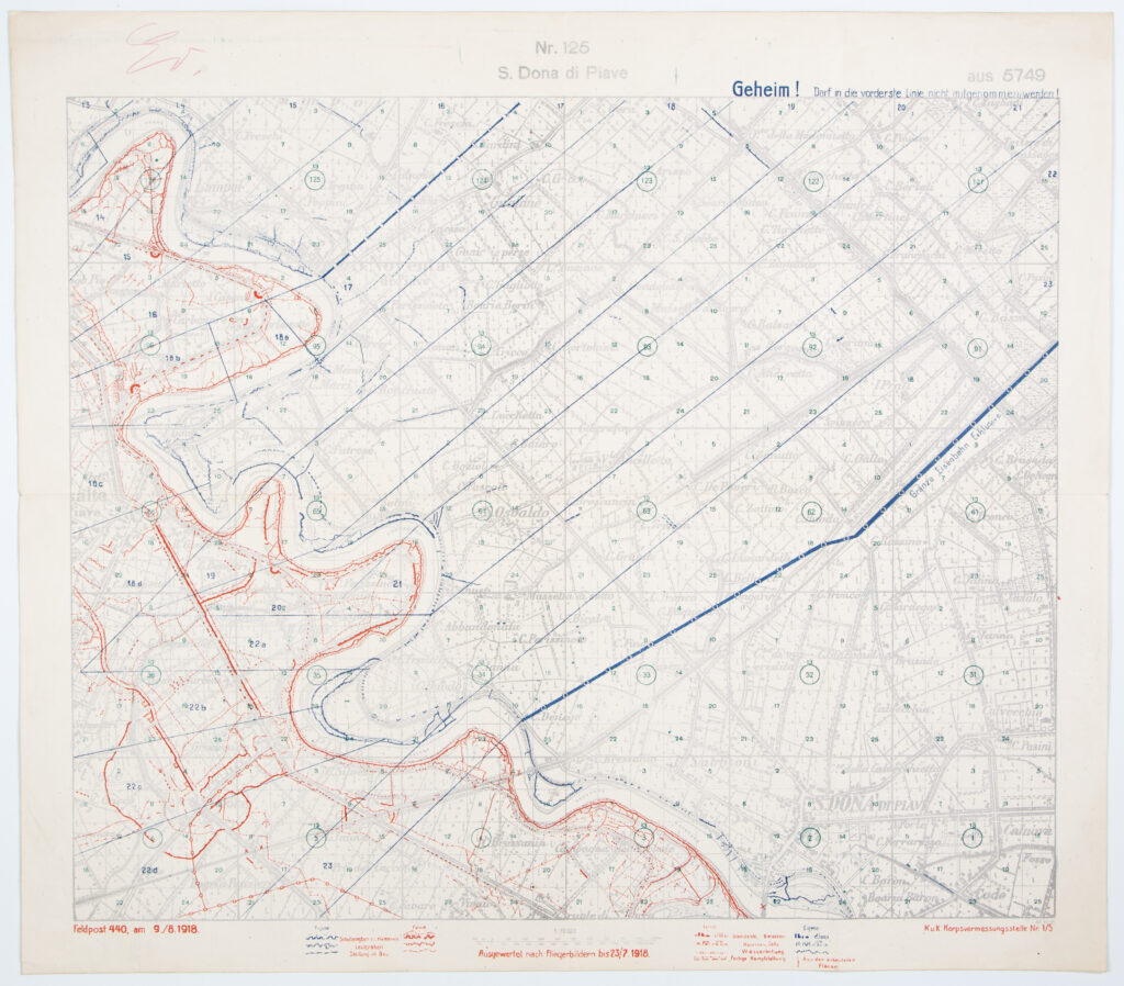
note and map title in upper middle: ‘Nr. 125 / S. Dona di Piave’; u. r.: section number and note: ‘aus 5749 / Geheim! Darf in die vordertste Linie nich mitgenommenwerden!’; l. l.: date: ‘Feldpost 440, am 9. / 8. 1918.’; lower middle: ‘Ausgewertet nach Fliegerbildern bis 23 / 7.1918’ and map key; l. r.: ‘22.vi 18 / K.u.K. Korpsvernessungsstelle Nr 1/5’
The map depicts the final advance of the Austro-Hungarian army on the Italian Front, i.e. the breakthrough across the Piave river in June 1918. The map was made for the needs of frontal warfare, in a large scale, using the special map of the Austro-Hungarian Monarchy (‘Spezialkarte der Osterreichisch-Ungarischen Monarchie) in 1:75,000 scale, section 5,749. Noted on the map is that it uses using aerial recordings taken on 23 July 1918 or earlier for depicting unit positions. Also noted is logistical data, such as the positions of the Austro-Hungarian and Italian armies, positions under construction, shelters, barracks and caverns, and trenches and acoustical barriers. The map is marked as secret (‘Carrying on the front lines is prohibited!’).
Izvori / literatura: Dadoh zlato za željezo: Prvi svjetski rat u zbirkama Hrvatskog povijesnog muzeja: 2011., pp. 283–284
error: Sadržaj je zaštićen!
Hrvatski povijesni muzej
Map of the S. Dona di Piave Area
Description:
The map depicts the final advance of the Austro-Hungarian army on the Italian Front, i.e. the breakthrough across the Piave river in June 1918. The map was made for the needs of frontal warfare, in a large scale, using the special map of the Austro-Hungarian Monarchy (‘Spezialkarte der Osterreichisch-Ungarischen Monarchie) in 1:75,000 scale, section 5,749. Noted on the map is that it uses using aerial recordings taken on 23 July 1918 or earlier for depicting unit positions. Also noted is logistical data, such as the positions of the Austro-Hungarian and Italian armies, positions under construction, shelters, barracks and caverns, and trenches and acoustical barriers. The map is marked as secret (‘Carrying on the front lines is prohibited!’).