Overview Sheet for Topographic Maps in 1:100,000 and 1:200,000 Scale
Military Geographical Institute,
Belgrade,
from 1901 to 1950
Paper, full colour print; 41 x 54.8 cm;
scale: 1:300,000;
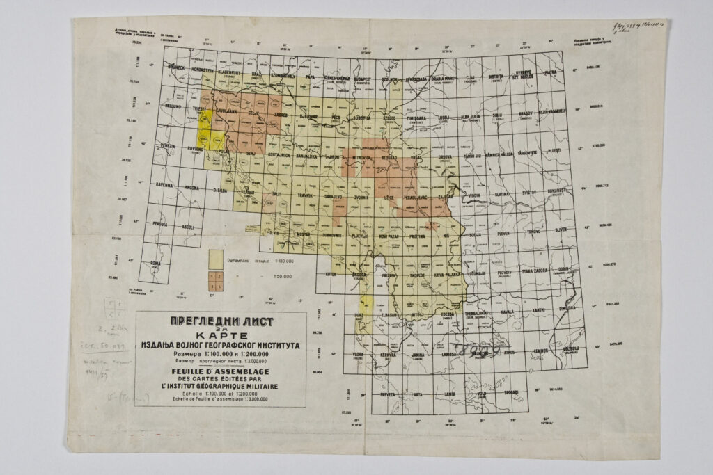
title l. l.: ‘PREGLEDNI LIST / ZA / KARTE / IZDANJA VOJNO GEOGRAFSKOG INSTITUTA / Razmera 1:100 000 i 1:200 000 / Razmer preglednog lista 1:300 000 = FEUILLE D' ASSEMBLAGE / DES CARTES EDITEES PAR / L' INSTITUT GEOGRAPHIQUE MILITAIRE / Echelle 1:100 000 et 1:200 000 / Echelle de Feuille d' assemblage 1:300 000’; u. l.: ‘Dužine lukova paralela i / meredijana u kilometrima’; u. r.: ‘Površina sekcija u / kvadratnim kilometrima’
Overview sheet with nomenclature of topographic map sheets of the territory of the Kingdom of Yugoslavia published by the Military Geographical Institute. Most of the territory is covered by sheets in 1:100,000 scale, while certain parts of the sheets ‘Trieste’, ‘Ljubljana’, ‘Celje’, ‘Zagreb’, ‘Senj’, ‘Pula’, ‘Split’, ‘Brod’, ‘Mitrovica’, ‘Belgrade’, ‘Vršac’, ‘Sarajevo’, ‘Užice’, ‘Kragujevac’, ‘Zaječar’, ‘Priština’, and ‘Niš’ are depicted in 1:50,000 scale.
Izvori / literatura: first publication
error: Sadržaj je zaštićen!
Hrvatski povijesni muzej
Overview Sheet for Topographic Maps in 1:100,000 and 1:200,000 Scale
Description:
Overview sheet with nomenclature of topographic map sheets of the territory of the Kingdom of Yugoslavia published by the Military Geographical Institute. Most of the territory is covered by sheets in 1:100,000 scale, while certain parts of the sheets ‘Trieste’, ‘Ljubljana’, ‘Celje’, ‘Zagreb’, ‘Senj’, ‘Pula’, ‘Split’, ‘Brod’, ‘Mitrovica’, ‘Belgrade’, ‘Vršac’, ‘Sarajevo’, ‘Užice’, ‘Kragujevac’, ‘Zaječar’, ‘Priština’, and ‘Niš’ are depicted in 1:50,000 scale.