Paper on canvas, print; 38,8 × 52,3 cm; scale: 1:140,000; u. r.: title: ‘KRIEGSTRASSEN KARTE / EINES TEEILES VON RUSSLAND / und / DER ANGRAENZENDEN LAENDER.’, information about map production and publisher: ‘Nach der unter der Leitung des Rufs. kaiserlichen Generalstabes / von General Major Schubert / im Mafstabe von 1:680 000 im Jahre 1829 herausgegeben Karte- / al dans Mafs von 1:140 000 vergröfsert, von dem / k.k. österr. Generalquartiermesisterstabe / HERAUSGEGEBEN IM JAHRE 1837.’ and map key; u. l.: table of the territorial organisation of Russia, Prussia, and Sweden with the neighbouring lands; l. l.: list of abbreviations in Russian and German with explanation: ‘Schrift=Abkürzungen im Bereich von Russland.’
Found in the Museum
HPM/PMH-9537
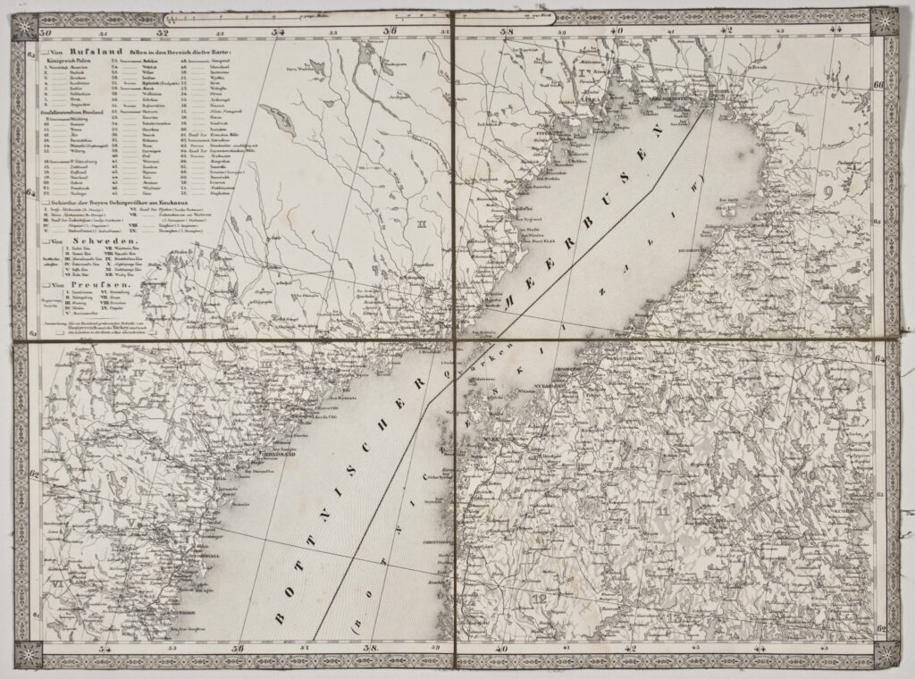
Overview map of a part of Russia and the neighbouring lands with a depiction of the traffic infrastructure. The first edition of the map was published in 1829, and the revised edition with magnifications in 1837. Twelve map sheets with many toponyms depict the northern territory of Russia with Siberia and the White Sea, a part of the Kingdom of Sweden with the Baltic Sea and Gulf of Bothnia, part of western and eastern Prussia, the southern territory of Russia with Galicia, Moldavia, Wallachia, the Black Sea, and the Crimean Peninsula and the territories of Georgia and Armenia, which are labelled ‘Freye Bergvölker’ (free mountain peoples) on the map.

Overview map of a part of Russia and the neighbouring lands with a depiction of the traffic infrastructure. The first edition of the map was published in 1829, and the revised edition with magnifications in 1837. Twelve map sheets with many toponyms depict the northern territory of Russia with Siberia and the White Sea, a part of the Kingdom of Sweden with the Baltic Sea and Gulf of Bothnia, part of western and eastern Prussia, the southern territory of Russia with Galicia, Moldavia, Wallachia, the Black Sea, and the Crimean Peninsula and the territories of Georgia and Armenia, which are labelled ‘Freye Bergvölker’ (free mountain peoples) on the map.
Overview map of a part of Russia and the neighbouring lands with a depiction of the traffic infrastructure. The first edition of the map was published in 1829, and the revised edition with magnifications in 1837. Twelve map sheets with many toponyms depict the northern territory of Russia with Siberia and the White Sea, a part of the Kingdom of Sweden with the Baltic Sea and Gulf of Bothnia, part of western and eastern Prussia, the southern territory of Russia with Galicia, Moldavia, Wallachia, the Black Sea, and the Crimean Peninsula and the territories of Georgia and Armenia, which are labelled ‘Freye Bergvölker’ (free mountain peoples) on the map.
Overview map of a part of Russia and the neighbouring lands with a depiction of the traffic infrastructure. The first edition of the map was published in 1829, and the revised edition with magnifications in 1837. Twelve map sheets with many toponyms depict the northern territory of Russia with Siberia and the White Sea, a part of the Kingdom of Sweden with the Baltic Sea and Gulf of Bothnia, part of western and eastern Prussia, the southern territory of Russia with Galicia, Moldavia, Wallachia, the Black Sea, and the Crimean Peninsula and the territories of Georgia and Armenia, which are labelled ‘Freye Bergvölker’ (free mountain peoples) on the map.
Overview map of a part of Russia and the neighbouring lands with a depiction of the traffic infrastructure. The first edition of the map was published in 1829, and the revised edition with magnifications in 1837. Twelve map sheets with many toponyms depict the northern territory of Russia with Siberia and the White Sea, a part of the Kingdom of Sweden with the Baltic Sea and Gulf of Bothnia, part of western and eastern Prussia, the southern territory of Russia with Galicia, Moldavia, Wallachia, the Black Sea, and the Crimean Peninsula and the territories of Georgia and Armenia, which are labelled ‘Freye Bergvölker’ (free mountain peoples) on the map.
Overview map of a part of Russia and the neighbouring lands with a depiction of the traffic infrastructure. The first edition of the map was published in 1829, and the revised edition with magnifications in 1837. Twelve map sheets with many toponyms depict the northern territory of Russia with Siberia and the White Sea, a part of the Kingdom of Sweden with the Baltic Sea and Gulf of Bothnia, part of western and eastern Prussia, the southern territory of Russia with Galicia, Moldavia, Wallachia, the Black Sea, and the Crimean Peninsula and the territories of Georgia and Armenia, which are labelled ‘Freye Bergvölker’ (free mountain peoples) on the map.
Overview map of a part of Russia and the neighbouring lands with a depiction of the traffic infrastructure. The first edition of the map was published in 1829, and the revised edition with magnifications in 1837. Twelve map sheets with many toponyms depict the northern territory of Russia with Siberia and the White Sea, a part of the Kingdom of Sweden with the Baltic Sea and Gulf of Bothnia, part of western and eastern Prussia, the southern territory of Russia with Galicia, Moldavia, Wallachia, the Black Sea, and the Crimean Peninsula and the territories of Georgia and Armenia, which are labelled ‘Freye Bergvölker’ (free mountain peoples) on the map.
Overview map of a part of Russia and the neighbouring lands with a depiction of the traffic infrastructure. The first edition of the map was published in 1829, and the revised edition with magnifications in 1837. Twelve map sheets with many toponyms depict the northern territory of Russia with Siberia and the White Sea, a part of the Kingdom of Sweden with the Baltic Sea and Gulf of Bothnia, part of western and eastern Prussia, the southern territory of Russia with Galicia, Moldavia, Wallachia, the Black Sea, and the Crimean Peninsula and the territories of Georgia and Armenia, which are labelled ‘Freye Bergvölker’ (free mountain peoples) on the map.
Overview map of a part of Russia and the neighbouring lands with a depiction of the traffic infrastructure. The first edition of the map was published in 1829, and the revised edition with magnifications in 1837. Twelve map sheets with many toponyms depict the northern territory of Russia with Siberia and the White Sea, a part of the Kingdom of Sweden with the Baltic Sea and Gulf of Bothnia, part of western and eastern Prussia, the southern territory of Russia with Galicia, Moldavia, Wallachia, the Black Sea, and the Crimean Peninsula and the territories of Georgia and Armenia, which are labelled ‘Freye Bergvölker’ (free mountain peoples) on the map.
Overview map of a part of Russia and the neighbouring lands with a depiction of the traffic infrastructure. The first edition of the map was published in 1829, and the revised edition with magnifications in 1837. Twelve map sheets with many toponyms depict the northern territory of Russia with Siberia and the White Sea, a part of the Kingdom of Sweden with the Baltic Sea and Gulf of Bothnia, part of western and eastern Prussia, the southern territory of Russia with Galicia, Moldavia, Wallachia, the Black Sea, and the Crimean Peninsula and the territories of Georgia and Armenia, which are labelled ‘Freye Bergvölker’ (free mountain peoples) on the map.
Overview map of a part of Russia and the neighbouring lands with a depiction of the traffic infrastructure. The first edition of the map was published in 1829, and the revised edition with magnifications in 1837. Twelve map sheets with many toponyms depict the northern territory of Russia with Siberia and the White Sea, a part of the Kingdom of Sweden with the Baltic Sea and Gulf of Bothnia, part of western and eastern Prussia, the southern territory of Russia with Galicia, Moldavia, Wallachia, the Black Sea, and the Crimean Peninsula and the territories of Georgia and Armenia, which are labelled ‘Freye Bergvölker’ (free mountain peoples) on the map.
Overview map of a part of Russia and the neighbouring lands with a depiction of the traffic infrastructure. The first edition of the map was published in 1829, and the revised edition with magnifications in 1837. Twelve map sheets with many toponyms depict the northern territory of Russia with Siberia and the White Sea, a part of the Kingdom of Sweden with the Baltic Sea and Gulf of Bothnia, part of western and eastern Prussia, the southern territory of Russia with Galicia, Moldavia, Wallachia, the Black Sea, and the Crimean Peninsula and the territories of Georgia and Armenia, which are labelled ‘Freye Bergvölker’ (free mountain peoples) on the map.
Overview map of a part of Russia and the neighbouring lands with a depiction of the traffic infrastructure. The first edition of the map was published in 1829, and the revised edition with magnifications in 1837. Twelve map sheets with many toponyms depict the northern territory of Russia with Siberia and the White Sea, a part of the Kingdom of Sweden with the Baltic Sea and Gulf of Bothnia, part of western and eastern Prussia, the southern territory of Russia with Galicia, Moldavia, Wallachia, the Black Sea, and the Crimean Peninsula and the territories of Georgia and Armenia, which are labelled ‘Freye Bergvölker’ (free mountain peoples) on the map.