Container: cardboard, glued, maps: paper on canvas, print; from 22.5 x 34.5 cm to 45 x 52 cm; 1 : 300 000; on volume cover: ‘Generalkarte / von / Central-Europa’; l. l.: note on each map sheet: ‘(Preis 60 kr.)’; l. r. on each map sheet: year of publication; on each map sheet: note on production technique: ‘Vervielfältigt durch Umdruck vom Steine’; on reverse of each map sheet: nomenclature with name of the depicted city/province; on separate sheets: map key, list of abbreviations, and various scales; individual volumes also contain overview sheets entitled: ‘ÜBERSICHTS – BLATT / fur die Zusammensteilung der Blätter der Karte von Central – Europa / im Masse 1:300.000 der Natur.’ with positions and labels for the general map of central Europe in 1:300,000 scale and for the special and general map of the Austro-Hungarian Monarchy in 1:75,000 and 1:300,000 scale: ‘ÜBERSICHTS – BLATT / für die General – Karte von Central – Europa / im Maſse 1:300.000 der Natur.’ in 1:8,500,000 scale.
Received from the 16th Imperial and Royal Varaždin Infantry Regiment
HPM/PMH-9670 – HPM/PMH-9692, HPM/PMH-9693 – HPM/PMH-9715, HPM/PMH-9716 – HPM/PMH-9738, HPM/PMH-9739 – HPM/PMH-9761, HPM/PMH-9762 – HPM/PMH-9782, HPM/PMH-9783 – HPM/PMH-9798, HPM/PMH-9799 – HPM/PMH-9818, HPM/PMH-9819 – HPM/PMH-9841, HPM/PMH-9842 – HPM/PMH-9853/a
The nine volumes of this general map of central Europe contain 198 cartographical sheets, with a general depiction and organisation of central European countries and provinces during the second half of the 19th century. The volumes also contain maps depicting a part of the territory of the Triune Kingdom of Croatia, Slavonia and Dalmatia, on sheets: H.10. (Pula), H.11., I.9. (Zagreb), I.10. (Glina), I.11. (Split), I.12. (Vis island), J.9. (Osijek), J.10. (Slavonski Brod), and J.12. (Dubrovnik). The map sheets are ordered alphabetically and according to nomenclatures, with city and/or province names as follows:
Sheet A.1. Manchester
Sheet A.2. Birmingham
Sheet A.3. London
Sheet A.4. missing
Sheet A.5. Le Havre
Sheet A.6. Le Mans
Sheet A.7. Tours
Sheet A.8. Limoges
Sheet A.9. Périgueux
Sheet A.10. Toulouse
Sheet A.11. missing
Sheet A.12. Barcelona
Sheet B.1. Hull (today Kingston upon Hull)
Sheet B.2. Norwich
Sheet B.3. Cambridge
Sheet B.4. Calais
Sheet B.5. Amiens
Sheet B.6. Paris
Sheet B.7. missing
Sheet B.8. Moulins
Sheet B.9. Le Puy (today Le Puy-en-Velay)
Sheet B.10. Montpellier
Sheet B.11. Golf v. Lyon (today the Gulf of Lion)
Sheet B.12. Toroella de Montgri (today Toroella de Montegrí)
Title sheet of map C.1.: ‘TITEL / zur / General-Karte / von / CENTRAL-EUROPA.’
Sheet with map key C.2.: ‘ZEICHENERKLÄRUNG / zur / General-Karte / von / CENTRAL-EUROPA.’
Sheet C.3. S Gravenhage (today The Hague)
Sheet C.4. Brüssel (today Brussels)
Sheet C.5. St. Quentin (today Saint-Quentin)
Sheet C.6. Rheims
Sheet C.7. Dijon
Sheet C.8. Macon
Sheet C.9. Lyon
Sheet C.10. Avignon
Sheet C.11. Marseille
Sheet C.12. missing
Title sheet of map D.1.: ‘Titel / zur / General-Karte / der / Österr. Ungar. / MONARCHIE.’
Sheet D.2. Texel
Sheet D.3. Amsterdam
Sheet D.4. Aachen
Sheet D.5. Luxembourg
Sheet D.6. Metz
Sheet D.7. Belfort
Sheet D.8. Genf (today Geneva)
Sheet D.9. Turin
Sheet D.10. Cuneo
Sheet D.11. Antibes
Overview sheet for the general and special map of the Austro-Hungarian Monarchy D.12.: ‘SKELETT / der / General- / und der neuen / Specfial-Karte / von / ÖSTERR.-UNGARN.’
Sheet E.1. missing
Sheet E.2. Wilhelmshafen (today Wilhelmshaven)
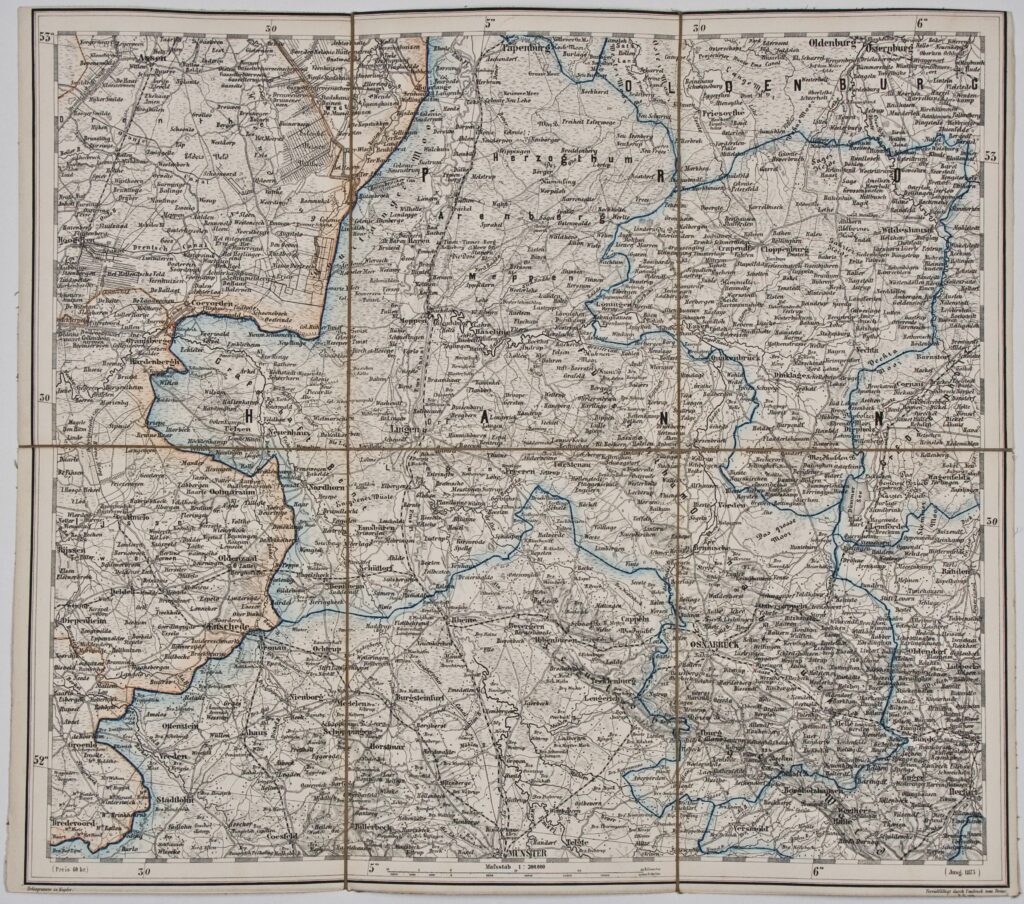
Sheet E.3. Osnabrück
Sheet E.4. Cöln (today Cologne)
Sheet E.5. Mainz
Sheet E.6. Strassburg (today Strasbourg)
Sheet E.7. Basel
Sheet E.8. Zürich (today Zurich)
Sheet E.9. Mailand (today Milan)
Sheet E.10. Genua (today Genoa)
Sheet E.11. Mittelländisches Meer (today part of the Mediterranean Sea)
Sheet E.12. Corsica
Sheet F.1. Schleswig (today Schleswig-Holstein)
Sheet F.2. Hamburg
Sheet F.3. Bremen
Sheet F.4. Cassel
Sheet F.5. Fulda
Sheet F.6. Nürnberg (today Nuremberg)
Sheet F.7. Ulm
Sheet F.8. Innsbruck
Sheet F.9. Verona
Sheet F.10. Bologna
Sheet F.11. Florenz (today Florence)
Sheet F.12. Civitavecchia
Sheet G.1. Seeland (today the eastern coast of Denmark)
Sheet G.2. Lübeck
Sheet G.3. Brandenburg
Sheet G.4. Leipzig
Sheet G.5. Eger
Sheet G.6. Regensburg
Sheet G.7. München (today Munich)
Sheet G.8. Lienz
Sheet G.9. Venedig (today Venice)
Sheet G.10. Comacchio
Sheet G.11. Ancona
Sheet G.12. Rom (today Rome)
Sheet H.1. Malmö
Sheet H.2. missing
Sheet H.3. Berlin
Sheet H.4. Kattbus (today Cottbus)
Sheet H.5. Prag (today Prague)
Sheet H.6. Budweis (today České Budějovice)
Sheet H.7. Steyr
Sheet H.8. Klagenfurt
Sheet H.9. Trieste
Sheet H.10. Pola (today Pula)
Sheet H.11. Adriatic Sea (today part of the eastern Adriatic coast)
Sheet H.12. Ortona
Sheet I.1. Bornholm
Sheet I.2. Kolberg (today Kołobrzeg)
Sheet I.3. Posen (today Poznań)
Sheet I.4. Glogau (today Głogów)
Sheet I.5. Freiburg
Sheet I.6. Brünn (today Brno)
Sheet I.7. Wien (today Vienna)
Sheet I.8. Gratz (today Graz)
Sheet I.9. Agram (today Zagreb)
Sheet I.10. Glina
Sheet I.11. Spalato (today Split)
Sheet I.12. I. Lissa (today Vis island)
Sheet J.1. Baltic Sea area
Sheet J.2. missing
Sheet J.3. Thorn (today Toruń)
Sheet J.4. Kalisz
Sheet J.5. Oppeln (today Opole)
Sheet J.6. Olomouc
Sheet J.7. Komorn (today Komárno)
Sheet J.8. Buda-Pest (today Budapest)
Sheet J.9. Eszeg (today Osijek)
Sheet J.10. Brod (today Slavonski Brod)
Sheet J.11. Bosna Serai (today Sarajevo)
Sheet J.12. Ragusa (today Dubrovnik)
Sheet K.1. Königsberg (today Kaliningrad)
Sheet K.2. missing
Sheet K.3. Nowo Georgiewsk (today Nowy Dwór Mazowiecki)
Sheet K.4. Warschau (today Warsaw)
Sheet K.5. Krakau (today Kraków)
Sheet K.6. Leutschau (today Letovača)
Sheet K.7. Miskolcz (today Miskolc)
Sheet K.8. Kecskemet (today Kecskemét)
Sheet K.9. Szegedin (today Szeged)
Sheet K.10. Belgrad (today Belgrade)
Sheet K.11. Užice
Sheet K.12. Scutari (today Shkodër)
Sheet L.1. Kowno (today Kaunas)
Sheet L.2. Suwałki
Sheet L.3. Bjelostok (today Bjałystok)
Sheet L.4. Lublin
Sheet L.5. Bilogoray (today Biłgoraj)
Sheet L.6. missing
Sheet L.7. M. Tokaj (today Tokaj)
Sheet L.8. Debreczen (today Debrecen)
Sheet L.9. Temesvar (today Timişoara)
Sheet L.10. Orsova (today Orşova)
Sheet L.12. Pristina
Sheet L.11. Kruševac
Sheet M.1. Wiljna (today Vilnius)
Sheet M.2. Grodno
Sheet M.3. Slonim
Sheet M.4. Brest Litowskij (today Brest)
Sheet M.5. Brody
Sheet M.6. Stanislau (today Ivano-Frankivsk)
Sheet M.7. Czernowitz (today Chernivtsi)
Sheet M.8. Klausenburg (today Cluj-Napoca)
Sheet M.9. Hermannstadt (today Sibiu)
Sheet M.10. Kraiova (today Craiova)
Sheet M.11. Vidin
Sheet M.12. Sofia
Sheet N.1. Dolginow (today Daŭhinava)
Sheet N.2. Minsk
Sheet N.3. Pinsk
Sheet N.4. Kolki (today Kolky)
Sheet N.5. Ostrog
Sheet N.6. Tarnopol (today Ternopil)
Sheet N.7. missing
Sheet N.8. Gyergyo Sz. Miklòs (today Gheorgheni)
Sheet N.9. Kronstadt (today Braşov)
Sheet N.10. Bukuresti (today Bucharest)
Sheet N.11. Rusčuk (today Ruse Province in Bulgaria)
Sheet N.12. Philippopel (today Plovdiv)
Sheet O.1. Borisow (today Barysaw)
Sheet O.2. Bobrujsk today Babruysk
Sheet O.3. Mozyri (today Mazir)
Sheet O.4. Owruczj
Sheet O.5. Žitomir (today Zhytomyr)
Sheet O.6. Braclaw (today Bratslav)
Sheet O.7. Jampolj (today Yampil’)
Sheet O.8. Jassi (today Iaşi)
Sheet O.9. Brailo (today Brailă)
Sheet O.10. Silistria (today Silistra)
Sheet O.11. Šumla (today Shumen)
Sheet O.12. Burgas
Sheet P.1. Smolensk
Sheet P.2. Czerikow (today Czerniaków)
Sheet P.3. Gomelj (today Gomel)
Sheet P.4. Morowsk
Sheet P.5. Kiew (today Kiev)
Sheet P.6. Umanj (today Uman)
Sheet P.7. Balta
Sheet P.8. Odessa
Sheet P.9. Kilia (today Kiliia)
Sheet P.10. Schwarzes Meer (today the western coast of the Black Sea)
Sheet P.11. Cap Gülgrad
Sheet P.12. Cap. S. Stefanos

The nine volumes of this general map of central Europe contain 198 cartographical sheets, with a general depiction and organisation of central European countries and provinces during the second half of the 19th century. The volumes also contain maps depicting a part of the territory of the Triune Kingdom of Croatia, Slavonia and Dalmatia, on sheets: H.10. (Pula), H.11., I.9. (Zagreb), I.10. (Glina), I.11. (Split), I.12. (Vis island), J.9. (Osijek), J.10. (Slavonski Brod), and J.12. (Dubrovnik). The map sheets are ordered alphabetically and according to nomenclatures, with city and/or province names as follows:
Sheet A.1. Manchester
Sheet A.2. Birmingham
Sheet A.3. London
Sheet A.4. missing
Sheet A.5. Le Havre
Sheet A.6. Le Mans
Sheet A.7. Tours
Sheet A.8. Limoges
Sheet A.9. Périgueux
Sheet A.10. Toulouse
Sheet A.11. missing
Sheet A.12. Barcelona
Sheet B.1. Hull (today Kingston upon Hull)
Sheet B.2. Norwich
Sheet B.3. Cambridge
Sheet B.4. Calais
Sheet B.5. Amiens
Sheet B.6. Paris
Sheet B.7. missing
Sheet B.8. Moulins
Sheet B.9. Le Puy (today Le Puy-en-Velay)
Sheet B.10. Montpellier
Sheet B.11. Golf v. Lyon (today the Gulf of Lion)
Sheet B.12. Toroella de Montgri (today Toroella de Montegrí)
Title sheet of map C.1.: ‘TITEL / zur / General-Karte / von / CENTRAL-EUROPA.’
Sheet with map key C.2.: ‘ZEICHENERKLÄRUNG / zur / General-Karte / von / CENTRAL-EUROPA.’
Sheet C.3. S Gravenhage (today The Hague)
Sheet C.4. Brüssel (today Brussels)
Sheet C.5. St. Quentin (today Saint-Quentin)
Sheet C.6. Rheims
Sheet C.7. Dijon
Sheet C.8. Macon
Sheet C.9. Lyon
Sheet C.10. Avignon
Sheet C.11. Marseille
Sheet C.12. missing
Title sheet of map D.1.: ‘Titel / zur / General-Karte / der / Österr. Ungar. / MONARCHIE.’
Sheet D.2. Texel
Sheet D.3. Amsterdam
Sheet D.4. Aachen
Sheet D.5. Luxembourg
Sheet D.6. Metz
Sheet D.7. Belfort
Sheet D.8. Genf (today Geneva)
Sheet D.9. Turin
Sheet D.10. Cuneo
Sheet D.11. Antibes
Overview sheet for the general and special map of the Austro-Hungarian Monarchy D.12.: ‘SKELETT / der / General- / und der neuen / Specfial-Karte / von / ÖSTERR.-UNGARN.’
Sheet E.1. missing
Sheet E.2. Wilhelmshafen (today Wilhelmshaven)
Sheet E.3. Osnabrück
Sheet E.4. Cöln (today Cologne)
Sheet E.5. Mainz
Sheet E.6. Strassburg (today Strasbourg)
Sheet E.7. Basel
Sheet E.8. Zürich (today Zurich)
Sheet E.9. Mailand (today Milan)
Sheet E.10. Genua (today Genoa)
Sheet E.11. Mittelländisches Meer (today part of the Mediterranean Sea)
Sheet E.12. Corsica
Sheet F.1. Schleswig (today Schleswig-Holstein)
Sheet F.2. Hamburg
Sheet F.3. Bremen
Sheet F.4. Cassel
Sheet F.5. Fulda
Sheet F.6. Nürnberg (today Nuremberg)
Sheet F.7. Ulm
Sheet F.8. Innsbruck
Sheet F.9. Verona
Sheet F.10. Bologna
Sheet F.11. Florenz (today Florence)
Sheet F.12. Civitavecchia
Sheet G.1. Seeland (today the eastern coast of Denmark)
Sheet G.2. Lübeck
Sheet G.3. Brandenburg
Sheet G.4. Leipzig
Sheet G.5. Eger
Sheet G.6. Regensburg
Sheet G.7. München (today Munich)
Sheet G.8. Lienz
Sheet G.9. Venedig (today Venice)
Sheet G.10. Comacchio
Sheet G.11. Ancona
Sheet G.12. Rom (today Rome)
Sheet H.1. Malmö
Sheet H.2. missing
Sheet H.3. Berlin
Sheet H.4. Kattbus (today Cottbus)
Sheet H.5. Prag (today Prague)
Sheet H.6. Budweis (today České Budějovice)
Sheet H.7. Steyr
Sheet H.8. Klagenfurt
Sheet H.9. Trieste
Sheet H.10. Pola (today Pula)
Sheet H.11. Adriatic Sea (today part of the eastern Adriatic coast)
Sheet H.12. Ortona
Sheet I.1. Bornholm
Sheet I.2. Kolberg (today Kołobrzeg)
Sheet I.3. Posen (today Poznań)
Sheet I.4. Glogau (today Głogów)
Sheet I.5. Freiburg
Sheet I.6. Brünn (today Brno)
Sheet I.7. Wien (today Vienna)
Sheet I.8. Gratz (today Graz)
Sheet I.9. Agram (today Zagreb)
Sheet I.10. Glina
Sheet I.11. Spalato (today Split)
Sheet I.12. I. Lissa (today Vis island)
Sheet J.1. Baltic Sea area
Sheet J.2. missing
Sheet J.3. Thorn (today Toruń)
Sheet J.4. Kalisz
Sheet J.5. Oppeln (today Opole)
Sheet J.6. Olomouc
Sheet J.7. Komorn (today Komárno)
Sheet J.8. Buda-Pest (today Budapest)
Sheet J.9. Eszeg (today Osijek)
Sheet J.10. Brod (today Slavonski Brod)
Sheet J.11. Bosna Serai (today Sarajevo)
Sheet J.12. Ragusa (today Dubrovnik)
Sheet K.1. Königsberg (today Kaliningrad)
Sheet K.2. missing
Sheet K.3. Nowo Georgiewsk (today Nowy Dwór Mazowiecki)
Sheet K.4. Warschau (today Warsaw)
Sheet K.5. Krakau (today Kraków)
Sheet K.6. Leutschau (today Letovača)
Sheet K.7. Miskolcz (today Miskolc)
Sheet K.8. Kecskemet (today Kecskemét)
Sheet K.9. Szegedin (today Szeged)
Sheet K.10. Belgrad (today Belgrade)
Sheet K.11. Užice
Sheet K.12. Scutari (today Shkodër)
Sheet L.1. Kowno (today Kaunas)
Sheet L.2. Suwałki
Sheet L.3. Bjelostok (today Bjałystok)
Sheet L.4. Lublin
Sheet L.5. Bilogoray (today Biłgoraj)
Sheet L.6. missing
Sheet L.7. M. Tokaj (today Tokaj)
Sheet L.8. Debreczen (today Debrecen)
Sheet L.9. Temesvar (today Timişoara)
Sheet L.10. Orsova (today Orşova)
Sheet L.12. Pristina
Sheet L.11. Kruševac
Sheet M.1. Wiljna (today Vilnius)
Sheet M.2. Grodno
Sheet M.3. Slonim
Sheet M.4. Brest Litowskij (today Brest)
Sheet M.5. Brody
Sheet M.6. Stanislau (today Ivano-Frankivsk)
Sheet M.7. Czernowitz (today Chernivtsi)
Sheet M.8. Klausenburg (today Cluj-Napoca)
Sheet M.9. Hermannstadt (today Sibiu)
Sheet M.10. Kraiova (today Craiova)
Sheet M.11. Vidin
Sheet M.12. Sofia
Sheet N.1. Dolginow (today Daŭhinava)
Sheet N.2. Minsk
Sheet N.3. Pinsk
Sheet N.4. Kolki (today Kolky)
Sheet N.5. Ostrog
Sheet N.6. Tarnopol (today Ternopil)
Sheet N.7. missing
Sheet N.8. Gyergyo Sz. Miklòs (today Gheorgheni)
Sheet N.9. Kronstadt (today Braşov)
Sheet N.10. Bukuresti (today Bucharest)
Sheet N.11. Rusčuk (today Ruse Province in Bulgaria)
Sheet N.12. Philippopel (today Plovdiv)
Sheet O.1. Borisow (today Barysaw)
Sheet O.2. Bobrujsk today Babruysk
Sheet O.3. Mozyri (today Mazir)
Sheet O.4. Owruczj
Sheet O.5. Žitomir (today Zhytomyr)
Sheet O.6. Braclaw (today Bratslav)
Sheet O.7. Jampolj (today Yampil’)
Sheet O.8. Jassi (today Iaşi)
Sheet O.9. Brailo (today Brailă)
Sheet O.10. Silistria (today Silistra)
Sheet O.11. Šumla (today Shumen)
Sheet O.12. Burgas
Sheet P.1. Smolensk
Sheet P.2. Czerikow (today Czerniaków)
Sheet P.3. Gomelj (today Gomel)
Sheet P.4. Morowsk
Sheet P.5. Kiew (today Kiev)
Sheet P.6. Umanj (today Uman)
Sheet P.7. Balta
Sheet P.8. Odessa
Sheet P.9. Kilia (today Kiliia)
Sheet P.10. Schwarzes Meer (today the western coast of the Black Sea)
Sheet P.11. Cap Gülgrad
Sheet P.12. Cap. S. Stefanos