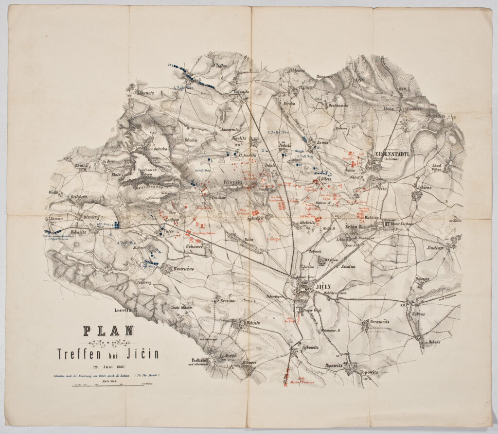
Paper on canvas, print; from 26.8 x 34.7 cm to 43 x 56 cm; paper, print; from 29.7 x 27.2 to 49 x 53 cm; ; scale: ca 1:2,880; 1:25,000; 1:28,800; plan titles: ‘Plan zum Treffen / bei / BLUMENAU und PRESSBURG, / 22. Juli 1866.’, ‘PLAN / zur / Schlacht von Langensalza / ( 27. Jun 1866.)’, ‘PLAN / zu dem / Treffen bei Wysokov (Nachod), bei Skalitz / und zum / Gefechte bei Schweinschädel. / 27, 28 und 29 Juni 1866.’, ‘PLAN / zum / Treffen bei Jičin / (29. Jun 1866)’, ‘PLAN / zum / TREFFEN bei KÖNIGINHOF / 29. Jun 1866.’, ‘PLAN / zum Gefechte bei / PODKOST / am 29. Jun 1866’, ‘Plan zu Recognoscirungs = Gefecht bei Versa / am 26 Jul 1866.’, ‘PLAN / zum / GEFECHTE bei OSWIECIM / am 27. Juni 1866.’, ‘PLAN / für die / GEFECHTE von TRAUTENAU / am 27. Juni und von / NEU - ROGNITZ / am 28. Juni 1866.’, ‘Plan / des Gefechtsfeldes von / Podkost / am 28.Juni 1866.’, ‘GEFECHTSFELD / der Elb-Armee bei / MÜNCHENGRÄTZ / 28.Juni 1866.’, ‘Plan / der Gefechtsfelder von / Podol / am 26.Juni, / und der 7. und 8.Division bei / MÜNCHENGRÄTZ / am 28.Juni 1866.’, ‘PLAN / zum / GEFECHTE bei PODOL / 26. Juni 1866.’, ‘Plan des Schlachtfeldes von Königgrätz / (3. Juli 1866.)’, ‘PLAN / zu den Gefechten bei / BISKUPITZ / 14 Juli / TOBITSCHAU und ROKETNITZ / 15 . Juli 1866.’; notes on individual sheets: on the depiction of the situation after the capture of Diletz (today Dílce) by the Saxon army on 29 June 1866: ‘Situation nach der Besetzung von Diletz durch Sie Sachsen. (:7 ½ Uhr Abends:)’; on conducted terrain recording: ‘Aufgenommen von Bothe, / ?’, ‘Aufgenommen im August 1866 / von / Gnügge, Hauptmann im Westfälischen Feld Art. Regt. No.7.’, ‘Aufgenommen und gezeichnet von / Bothe, Premier Lieutenant im Ulanen Regt.No.15’; on elevations: ‘Die höhenzahlen bezichen sich / aus den spfegel der nordsee.’; markings on individual sheets: ‘Blatt I.’, ‘Blatt II.’; round stamp on individual plans: ‘OFFICIERS BIBLIOTEK / K.K.WARASDINER INF.REGIMENT No 16’.
HPM/PMH-9966 - HPM/PMH-9980
These battle plans, which depict the deployment of Austrian and Prussian army units during the Prusso-Austrian War of 1866, are kept in the Cartographical Collection and are of various provenances: in 1919, the 16th Imperial and Royal Varaždin Infantry Regiment gave the plan of the battle near Versa to the holdings of the National Museum (HPM/PMH-9966); nine plans were inherited from the War Archive and Museum of the ISC (HPM/PMH-19730 – HPM/PMH-19732, HPM/PMH-19737, HPM/PMH-19745 – HPM/PMH-19746, HPM/PMH-19753, HPM/PMH-19758, HPM/PMH-19763), while a smaller number of plans from the mentioned period were found in the museum (HPM/PMH-9550, HPM/PMH-9552, HPM/PMH-9556, HPM/PMH-9978 – HPM/PMH-9980). During the second half of the 19th century, the conflict between Austria and Prussia for supremacy in the German Confederation, which escalated into the Prusso-Austrian War of 1866. Otto von Bismarck, the Prussian chancellor, secured the neutrality of certain European countries, formed alliances, and skilfully took advantage of the situation involving the Schleswig-Holstein province. On 16 June 1866, the Prussian army attacked Hanover, Hesse, and Saxony, lands allied to Austria. Already the next day, Austria sent its own forces towards Bohemia, where a decisive battle took place near Sadová on 3 July 1866, resulting in a Prussian victory. The war was concluded with a peace treaty in Prague on 23 August 1866. Defeated, Austria accepted Bismarck’s condition regarding the withdrawal of Austria from the German Confederation, which opened the way towards the unification of Germany.

These battle plans, which depict the deployment of Austrian and Prussian army units during the Prusso-Austrian War of 1866, are kept in the Cartographical Collection and are of various provenances: in 1919, the 16th Imperial and Royal Varaždin Infantry Regiment gave the plan of the battle near Versa to the holdings of the National Museum (HPM/PMH-9966); nine plans were inherited from the War Archive and Museum of the ISC (HPM/PMH-19730 – HPM/PMH-19732, HPM/PMH-19737, HPM/PMH-19745 – HPM/PMH-19746, HPM/PMH-19753, HPM/PMH-19758, HPM/PMH-19763), while a smaller number of plans from the mentioned period were found in the museum (HPM/PMH-9550, HPM/PMH-9552, HPM/PMH-9556, HPM/PMH-9978 – HPM/PMH-9980). During the second half of the 19th century, the conflict between Austria and Prussia for supremacy in the German Confederation, which escalated into the Prusso-Austrian War of 1866. Otto von Bismarck, the Prussian chancellor, secured the neutrality of certain European countries, formed alliances, and skilfully took advantage of the situation involving the Schleswig-Holstein province. On 16 June 1866, the Prussian army attacked Hanover, Hesse, and Saxony, lands allied to Austria. Already the next day, Austria sent its own forces towards Bohemia, where a decisive battle took place near Sadová on 3 July 1866, resulting in a Prussian victory. The war was concluded with a peace treaty in Prague on 23 August 1866. Defeated, Austria accepted Bismarck’s condition regarding the withdrawal of Austria from the German Confederation, which opened the way towards the unification of Germany.
These battle plans, which depict the deployment of Austrian and Prussian army units during the Prusso-Austrian War of 1866, are kept in the Cartographical Collection and are of various provenances: in 1919, the 16th Imperial and Royal Varaždin Infantry Regiment gave the plan of the battle near Versa to the holdings of the National Museum (HPM/PMH-9966); nine plans were inherited from the War Archive and Museum of the ISC (HPM/PMH-19730 – HPM/PMH-19732, HPM/PMH-19737, HPM/PMH-19745 – HPM/PMH-19746, HPM/PMH-19753, HPM/PMH-19758, HPM/PMH-19763), while a smaller number of plans from the mentioned period were found in the museum (HPM/PMH-9550, HPM/PMH-9552, HPM/PMH-9556, HPM/PMH-9978 – HPM/PMH-9980). During the second half of the 19th century, the conflict between Austria and Prussia for supremacy in the German Confederation, which escalated into the Prusso-Austrian War of 1866. Otto von Bismarck, the Prussian chancellor, secured the neutrality of certain European countries, formed alliances, and skilfully took advantage of the situation involving the Schleswig-Holstein province. On 16 June 1866, the Prussian army attacked Hanover, Hesse, and Saxony, lands allied to Austria. Already the next day, Austria sent its own forces towards Bohemia, where a decisive battle took place near Sadová on 3 July 1866, resulting in a Prussian victory. The war was concluded with a peace treaty in Prague on 23 August 1866. Defeated, Austria accepted Bismarck’s condition regarding the withdrawal of Austria from the German Confederation, which opened the way towards the unification of Germany.
These battle plans, which depict the deployment of Austrian and Prussian army units during the Prusso-Austrian War of 1866, are kept in the Cartographical Collection and are of various provenances: in 1919, the 16th Imperial and Royal Varaždin Infantry Regiment gave the plan of the battle near Versa to the holdings of the National Museum (HPM/PMH-9966); nine plans were inherited from the War Archive and Museum of the ISC (HPM/PMH-19730 – HPM/PMH-19732, HPM/PMH-19737, HPM/PMH-19745 – HPM/PMH-19746, HPM/PMH-19753, HPM/PMH-19758, HPM/PMH-19763), while a smaller number of plans from the mentioned period were found in the museum (HPM/PMH-9550, HPM/PMH-9552, HPM/PMH-9556, HPM/PMH-9978 – HPM/PMH-9980). During the second half of the 19th century, the conflict between Austria and Prussia for supremacy in the German Confederation, which escalated into the Prusso-Austrian War of 1866. Otto von Bismarck, the Prussian chancellor, secured the neutrality of certain European countries, formed alliances, and skilfully took advantage of the situation involving the Schleswig-Holstein province. On 16 June 1866, the Prussian army attacked Hanover, Hesse, and Saxony, lands allied to Austria. Already the next day, Austria sent its own forces towards Bohemia, where a decisive battle took place near Sadová on 3 July 1866, resulting in a Prussian victory. The war was concluded with a peace treaty in Prague on 23 August 1866. Defeated, Austria accepted Bismarck’s condition regarding the withdrawal of Austria from the German Confederation, which opened the way towards the unification of Germany.
These battle plans, which depict the deployment of Austrian and Prussian army units during the Prusso-Austrian War of 1866, are kept in the Cartographical Collection and are of various provenances: in 1919, the 16th Imperial and Royal Varaždin Infantry Regiment gave the plan of the battle near Versa to the holdings of the National Museum (HPM/PMH-9966); nine plans were inherited from the War Archive and Museum of the ISC (HPM/PMH-19730 – HPM/PMH-19732, HPM/PMH-19737, HPM/PMH-19745 – HPM/PMH-19746, HPM/PMH-19753, HPM/PMH-19758, HPM/PMH-19763), while a smaller number of plans from the mentioned period were found in the museum (HPM/PMH-9550, HPM/PMH-9552, HPM/PMH-9556, HPM/PMH-9978 – HPM/PMH-9980). During the second half of the 19th century, the conflict between Austria and Prussia for supremacy in the German Confederation, which escalated into the Prusso-Austrian War of 1866. Otto von Bismarck, the Prussian chancellor, secured the neutrality of certain European countries, formed alliances, and skilfully took advantage of the situation involving the Schleswig-Holstein province. On 16 June 1866, the Prussian army attacked Hanover, Hesse, and Saxony, lands allied to Austria. Already the next day, Austria sent its own forces towards Bohemia, where a decisive battle took place near Sadová on 3 July 1866, resulting in a Prussian victory. The war was concluded with a peace treaty in Prague on 23 August 1866. Defeated, Austria accepted Bismarck’s condition regarding the withdrawal of Austria from the German Confederation, which opened the way towards the unification of Germany.
These battle plans, which depict the deployment of Austrian and Prussian army units during the Prusso-Austrian War of 1866, are kept in the Cartographical Collection and are of various provenances: in 1919, the 16th Imperial and Royal Varaždin Infantry Regiment gave the plan of the battle near Versa to the holdings of the National Museum (HPM/PMH-9966); nine plans were inherited from the War Archive and Museum of the ISC (HPM/PMH-19730 – HPM/PMH-19732, HPM/PMH-19737, HPM/PMH-19745 – HPM/PMH-19746, HPM/PMH-19753, HPM/PMH-19758, HPM/PMH-19763), while a smaller number of plans from the mentioned period were found in the museum (HPM/PMH-9550, HPM/PMH-9552, HPM/PMH-9556, HPM/PMH-9978 – HPM/PMH-9980). During the second half of the 19th century, the conflict between Austria and Prussia for supremacy in the German Confederation, which escalated into the Prusso-Austrian War of 1866. Otto von Bismarck, the Prussian chancellor, secured the neutrality of certain European countries, formed alliances, and skilfully took advantage of the situation involving the Schleswig-Holstein province. On 16 June 1866, the Prussian army attacked Hanover, Hesse, and Saxony, lands allied to Austria. Already the next day, Austria sent its own forces towards Bohemia, where a decisive battle took place near Sadová on 3 July 1866, resulting in a Prussian victory. The war was concluded with a peace treaty in Prague on 23 August 1866. Defeated, Austria accepted Bismarck’s condition regarding the withdrawal of Austria from the German Confederation, which opened the way towards the unification of Germany.
These battle plans, which depict the deployment of Austrian and Prussian army units during the Prusso-Austrian War of 1866, are kept in the Cartographical Collection and are of various provenances: in 1919, the 16th Imperial and Royal Varaždin Infantry Regiment gave the plan of the battle near Versa to the holdings of the National Museum (HPM/PMH-9966); nine plans were inherited from the War Archive and Museum of the ISC (HPM/PMH-19730 – HPM/PMH-19732, HPM/PMH-19737, HPM/PMH-19745 – HPM/PMH-19746, HPM/PMH-19753, HPM/PMH-19758, HPM/PMH-19763), while a smaller number of plans from the mentioned period were found in the museum (HPM/PMH-9550, HPM/PMH-9552, HPM/PMH-9556, HPM/PMH-9978 – HPM/PMH-9980). During the second half of the 19th century, the conflict between Austria and Prussia for supremacy in the German Confederation, which escalated into the Prusso-Austrian War of 1866. Otto von Bismarck, the Prussian chancellor, secured the neutrality of certain European countries, formed alliances, and skilfully took advantage of the situation involving the Schleswig-Holstein province. On 16 June 1866, the Prussian army attacked Hanover, Hesse, and Saxony, lands allied to Austria. Already the next day, Austria sent its own forces towards Bohemia, where a decisive battle took place near Sadová on 3 July 1866, resulting in a Prussian victory. The war was concluded with a peace treaty in Prague on 23 August 1866. Defeated, Austria accepted Bismarck’s condition regarding the withdrawal of Austria from the German Confederation, which opened the way towards the unification of Germany.
These battle plans, which depict the deployment of Austrian and Prussian army units during the Prusso-Austrian War of 1866, are kept in the Cartographical Collection and are of various provenances: in 1919, the 16th Imperial and Royal Varaždin Infantry Regiment gave the plan of the battle near Versa to the holdings of the National Museum (HPM/PMH-9966); nine plans were inherited from the War Archive and Museum of the ISC (HPM/PMH-19730 – HPM/PMH-19732, HPM/PMH-19737, HPM/PMH-19745 – HPM/PMH-19746, HPM/PMH-19753, HPM/PMH-19758, HPM/PMH-19763), while a smaller number of plans from the mentioned period were found in the museum (HPM/PMH-9550, HPM/PMH-9552, HPM/PMH-9556, HPM/PMH-9978 – HPM/PMH-9980). During the second half of the 19th century, the conflict between Austria and Prussia for supremacy in the German Confederation, which escalated into the Prusso-Austrian War of 1866. Otto von Bismarck, the Prussian chancellor, secured the neutrality of certain European countries, formed alliances, and skilfully took advantage of the situation involving the Schleswig-Holstein province. On 16 June 1866, the Prussian army attacked Hanover, Hesse, and Saxony, lands allied to Austria. Already the next day, Austria sent its own forces towards Bohemia, where a decisive battle took place near Sadová on 3 July 1866, resulting in a Prussian victory. The war was concluded with a peace treaty in Prague on 23 August 1866. Defeated, Austria accepted Bismarck’s condition regarding the withdrawal of Austria from the German Confederation, which opened the way towards the unification of Germany.
These battle plans, which depict the deployment of Austrian and Prussian army units during the Prusso-Austrian War of 1866, are kept in the Cartographical Collection and are of various provenances: in 1919, the 16th Imperial and Royal Varaždin Infantry Regiment gave the plan of the battle near Versa to the holdings of the National Museum (HPM/PMH-9966); nine plans were inherited from the War Archive and Museum of the ISC (HPM/PMH-19730 – HPM/PMH-19732, HPM/PMH-19737, HPM/PMH-19745 – HPM/PMH-19746, HPM/PMH-19753, HPM/PMH-19758, HPM/PMH-19763), while a smaller number of plans from the mentioned period were found in the museum (HPM/PMH-9550, HPM/PMH-9552, HPM/PMH-9556, HPM/PMH-9978 – HPM/PMH-9980). During the second half of the 19th century, the conflict between Austria and Prussia for supremacy in the German Confederation, which escalated into the Prusso-Austrian War of 1866. Otto von Bismarck, the Prussian chancellor, secured the neutrality of certain European countries, formed alliances, and skilfully took advantage of the situation involving the Schleswig-Holstein province. On 16 June 1866, the Prussian army attacked Hanover, Hesse, and Saxony, lands allied to Austria. Already the next day, Austria sent its own forces towards Bohemia, where a decisive battle took place near Sadová on 3 July 1866, resulting in a Prussian victory. The war was concluded with a peace treaty in Prague on 23 August 1866. Defeated, Austria accepted Bismarck’s condition regarding the withdrawal of Austria from the German Confederation, which opened the way towards the unification of Germany.
These battle plans, which depict the deployment of Austrian and Prussian army units during the Prusso-Austrian War of 1866, are kept in the Cartographical Collection and are of various provenances: in 1919, the 16th Imperial and Royal Varaždin Infantry Regiment gave the plan of the battle near Versa to the holdings of the National Museum (HPM/PMH-9966); nine plans were inherited from the War Archive and Museum of the ISC (HPM/PMH-19730 – HPM/PMH-19732, HPM/PMH-19737, HPM/PMH-19745 – HPM/PMH-19746, HPM/PMH-19753, HPM/PMH-19758, HPM/PMH-19763), while a smaller number of plans from the mentioned period were found in the museum (HPM/PMH-9550, HPM/PMH-9552, HPM/PMH-9556, HPM/PMH-9978 – HPM/PMH-9980). During the second half of the 19th century, the conflict between Austria and Prussia for supremacy in the German Confederation, which escalated into the Prusso-Austrian War of 1866. Otto von Bismarck, the Prussian chancellor, secured the neutrality of certain European countries, formed alliances, and skilfully took advantage of the situation involving the Schleswig-Holstein province. On 16 June 1866, the Prussian army attacked Hanover, Hesse, and Saxony, lands allied to Austria. Already the next day, Austria sent its own forces towards Bohemia, where a decisive battle took place near Sadová on 3 July 1866, resulting in a Prussian victory. The war was concluded with a peace treaty in Prague on 23 August 1866. Defeated, Austria accepted Bismarck’s condition regarding the withdrawal of Austria from the German Confederation, which opened the way towards the unification of Germany.
These battle plans, which depict the deployment of Austrian and Prussian army units during the Prusso-Austrian War of 1866, are kept in the Cartographical Collection and are of various provenances: in 1919, the 16th Imperial and Royal Varaždin Infantry Regiment gave the plan of the battle near Versa to the holdings of the National Museum (HPM/PMH-9966); nine plans were inherited from the War Archive and Museum of the ISC (HPM/PMH-19730 – HPM/PMH-19732, HPM/PMH-19737, HPM/PMH-19745 – HPM/PMH-19746, HPM/PMH-19753, HPM/PMH-19758, HPM/PMH-19763), while a smaller number of plans from the mentioned period were found in the museum (HPM/PMH-9550, HPM/PMH-9552, HPM/PMH-9556, HPM/PMH-9978 – HPM/PMH-9980). During the second half of the 19th century, the conflict between Austria and Prussia for supremacy in the German Confederation, which escalated into the Prusso-Austrian War of 1866. Otto von Bismarck, the Prussian chancellor, secured the neutrality of certain European countries, formed alliances, and skilfully took advantage of the situation involving the Schleswig-Holstein province. On 16 June 1866, the Prussian army attacked Hanover, Hesse, and Saxony, lands allied to Austria. Already the next day, Austria sent its own forces towards Bohemia, where a decisive battle took place near Sadová on 3 July 1866, resulting in a Prussian victory. The war was concluded with a peace treaty in Prague on 23 August 1866. Defeated, Austria accepted Bismarck’s condition regarding the withdrawal of Austria from the German Confederation, which opened the way towards the unification of Germany.
These battle plans, which depict the deployment of Austrian and Prussian army units during the Prusso-Austrian War of 1866, are kept in the Cartographical Collection and are of various provenances: in 1919, the 16th Imperial and Royal Varaždin Infantry Regiment gave the plan of the battle near Versa to the holdings of the National Museum (HPM/PMH-9966); nine plans were inherited from the War Archive and Museum of the ISC (HPM/PMH-19730 – HPM/PMH-19732, HPM/PMH-19737, HPM/PMH-19745 – HPM/PMH-19746, HPM/PMH-19753, HPM/PMH-19758, HPM/PMH-19763), while a smaller number of plans from the mentioned period were found in the museum (HPM/PMH-9550, HPM/PMH-9552, HPM/PMH-9556, HPM/PMH-9978 – HPM/PMH-9980). During the second half of the 19th century, the conflict between Austria and Prussia for supremacy in the German Confederation, which escalated into the Prusso-Austrian War of 1866. Otto von Bismarck, the Prussian chancellor, secured the neutrality of certain European countries, formed alliances, and skilfully took advantage of the situation involving the Schleswig-Holstein province. On 16 June 1866, the Prussian army attacked Hanover, Hesse, and Saxony, lands allied to Austria. Already the next day, Austria sent its own forces towards Bohemia, where a decisive battle took place near Sadová on 3 July 1866, resulting in a Prussian victory. The war was concluded with a peace treaty in Prague on 23 August 1866. Defeated, Austria accepted Bismarck’s condition regarding the withdrawal of Austria from the German Confederation, which opened the way towards the unification of Germany.
These battle plans, which depict the deployment of Austrian and Prussian army units during the Prusso-Austrian War of 1866, are kept in the Cartographical Collection and are of various provenances: in 1919, the 16th Imperial and Royal Varaždin Infantry Regiment gave the plan of the battle near Versa to the holdings of the National Museum (HPM/PMH-9966); nine plans were inherited from the War Archive and Museum of the ISC (HPM/PMH-19730 – HPM/PMH-19732, HPM/PMH-19737, HPM/PMH-19745 – HPM/PMH-19746, HPM/PMH-19753, HPM/PMH-19758, HPM/PMH-19763), while a smaller number of plans from the mentioned period were found in the museum (HPM/PMH-9550, HPM/PMH-9552, HPM/PMH-9556, HPM/PMH-9978 – HPM/PMH-9980). During the second half of the 19th century, the conflict between Austria and Prussia for supremacy in the German Confederation, which escalated into the Prusso-Austrian War of 1866. Otto von Bismarck, the Prussian chancellor, secured the neutrality of certain European countries, formed alliances, and skilfully took advantage of the situation involving the Schleswig-Holstein province. On 16 June 1866, the Prussian army attacked Hanover, Hesse, and Saxony, lands allied to Austria. Already the next day, Austria sent its own forces towards Bohemia, where a decisive battle took place near Sadová on 3 July 1866, resulting in a Prussian victory. The war was concluded with a peace treaty in Prague on 23 August 1866. Defeated, Austria accepted Bismarck’s condition regarding the withdrawal of Austria from the German Confederation, which opened the way towards the unification of Germany.
These battle plans, which depict the deployment of Austrian and Prussian army units during the Prusso-Austrian War of 1866, are kept in the Cartographical Collection and are of various provenances: in 1919, the 16th Imperial and Royal Varaždin Infantry Regiment gave the plan of the battle near Versa to the holdings of the National Museum (HPM/PMH-9966); nine plans were inherited from the War Archive and Museum of the ISC (HPM/PMH-19730 – HPM/PMH-19732, HPM/PMH-19737, HPM/PMH-19745 – HPM/PMH-19746, HPM/PMH-19753, HPM/PMH-19758, HPM/PMH-19763), while a smaller number of plans from the mentioned period were found in the museum (HPM/PMH-9550, HPM/PMH-9552, HPM/PMH-9556, HPM/PMH-9978 – HPM/PMH-9980). During the second half of the 19th century, the conflict between Austria and Prussia for supremacy in the German Confederation, which escalated into the Prusso-Austrian War of 1866. Otto von Bismarck, the Prussian chancellor, secured the neutrality of certain European countries, formed alliances, and skilfully took advantage of the situation involving the Schleswig-Holstein province. On 16 June 1866, the Prussian army attacked Hanover, Hesse, and Saxony, lands allied to Austria. Already the next day, Austria sent its own forces towards Bohemia, where a decisive battle took place near Sadová on 3 July 1866, resulting in a Prussian victory. The war was concluded with a peace treaty in Prague on 23 August 1866. Defeated, Austria accepted Bismarck’s condition regarding the withdrawal of Austria from the German Confederation, which opened the way towards the unification of Germany.
These battle plans, which depict the deployment of Austrian and Prussian army units during the Prusso-Austrian War of 1866, are kept in the Cartographical Collection and are of various provenances: in 1919, the 16th Imperial and Royal Varaždin Infantry Regiment gave the plan of the battle near Versa to the holdings of the National Museum (HPM/PMH-9966); nine plans were inherited from the War Archive and Museum of the ISC (HPM/PMH-19730 – HPM/PMH-19732, HPM/PMH-19737, HPM/PMH-19745 – HPM/PMH-19746, HPM/PMH-19753, HPM/PMH-19758, HPM/PMH-19763), while a smaller number of plans from the mentioned period were found in the museum (HPM/PMH-9550, HPM/PMH-9552, HPM/PMH-9556, HPM/PMH-9978 – HPM/PMH-9980). During the second half of the 19th century, the conflict between Austria and Prussia for supremacy in the German Confederation, which escalated into the Prusso-Austrian War of 1866. Otto von Bismarck, the Prussian chancellor, secured the neutrality of certain European countries, formed alliances, and skilfully took advantage of the situation involving the Schleswig-Holstein province. On 16 June 1866, the Prussian army attacked Hanover, Hesse, and Saxony, lands allied to Austria. Already the next day, Austria sent its own forces towards Bohemia, where a decisive battle took place near Sadová on 3 July 1866, resulting in a Prussian victory. The war was concluded with a peace treaty in Prague on 23 August 1866. Defeated, Austria accepted Bismarck’s condition regarding the withdrawal of Austria from the German Confederation, which opened the way towards the unification of Germany.
These battle plans, which depict the deployment of Austrian and Prussian army units during the Prusso-Austrian War of 1866, are kept in the Cartographical Collection and are of various provenances: in 1919, the 16th Imperial and Royal Varaždin Infantry Regiment gave the plan of the battle near Versa to the holdings of the National Museum (HPM/PMH-9966); nine plans were inherited from the War Archive and Museum of the ISC (HPM/PMH-19730 – HPM/PMH-19732, HPM/PMH-19737, HPM/PMH-19745 – HPM/PMH-19746, HPM/PMH-19753, HPM/PMH-19758, HPM/PMH-19763), while a smaller number of plans from the mentioned period were found in the museum (HPM/PMH-9550, HPM/PMH-9552, HPM/PMH-9556, HPM/PMH-9978 – HPM/PMH-9980). During the second half of the 19th century, the conflict between Austria and Prussia for supremacy in the German Confederation, which escalated into the Prusso-Austrian War of 1866. Otto von Bismarck, the Prussian chancellor, secured the neutrality of certain European countries, formed alliances, and skilfully took advantage of the situation involving the Schleswig-Holstein province. On 16 June 1866, the Prussian army attacked Hanover, Hesse, and Saxony, lands allied to Austria. Already the next day, Austria sent its own forces towards Bohemia, where a decisive battle took place near Sadová on 3 July 1866, resulting in a Prussian victory. The war was concluded with a peace treaty in Prague on 23 August 1866. Defeated, Austria accepted Bismarck’s condition regarding the withdrawal of Austria from the German Confederation, which opened the way towards the unification of Germany.
These battle plans, which depict the deployment of Austrian and Prussian army units during the Prusso-Austrian War of 1866, are kept in the Cartographical Collection and are of various provenances: in 1919, the 16th Imperial and Royal Varaždin Infantry Regiment gave the plan of the battle near Versa to the holdings of the National Museum (HPM/PMH-9966); nine plans were inherited from the War Archive and Museum of the ISC (HPM/PMH-19730 – HPM/PMH-19732, HPM/PMH-19737, HPM/PMH-19745 – HPM/PMH-19746, HPM/PMH-19753, HPM/PMH-19758, HPM/PMH-19763), while a smaller number of plans from the mentioned period were found in the museum (HPM/PMH-9550, HPM/PMH-9552, HPM/PMH-9556, HPM/PMH-9978 – HPM/PMH-9980). During the second half of the 19th century, the conflict between Austria and Prussia for supremacy in the German Confederation, which escalated into the Prusso-Austrian War of 1866. Otto von Bismarck, the Prussian chancellor, secured the neutrality of certain European countries, formed alliances, and skilfully took advantage of the situation involving the Schleswig-Holstein province. On 16 June 1866, the Prussian army attacked Hanover, Hesse, and Saxony, lands allied to Austria. Already the next day, Austria sent its own forces towards Bohemia, where a decisive battle took place near Sadová on 3 July 1866, resulting in a Prussian victory. The war was concluded with a peace treaty in Prague on 23 August 1866. Defeated, Austria accepted Bismarck’s condition regarding the withdrawal of Austria from the German Confederation, which opened the way towards the unification of Germany.
These battle plans, which depict the deployment of Austrian and Prussian army units during the Prusso-Austrian War of 1866, are kept in the Cartographical Collection and are of various provenances: in 1919, the 16th Imperial and Royal Varaždin Infantry Regiment gave the plan of the battle near Versa to the holdings of the National Museum (HPM/PMH-9966); nine plans were inherited from the War Archive and Museum of the ISC (HPM/PMH-19730 – HPM/PMH-19732, HPM/PMH-19737, HPM/PMH-19745 – HPM/PMH-19746, HPM/PMH-19753, HPM/PMH-19758, HPM/PMH-19763), while a smaller number of plans from the mentioned period were found in the museum (HPM/PMH-9550, HPM/PMH-9552, HPM/PMH-9556, HPM/PMH-9978 – HPM/PMH-9980). During the second half of the 19th century, the conflict between Austria and Prussia for supremacy in the German Confederation, which escalated into the Prusso-Austrian War of 1866. Otto von Bismarck, the Prussian chancellor, secured the neutrality of certain European countries, formed alliances, and skilfully took advantage of the situation involving the Schleswig-Holstein province. On 16 June 1866, the Prussian army attacked Hanover, Hesse, and Saxony, lands allied to Austria. Already the next day, Austria sent its own forces towards Bohemia, where a decisive battle took place near Sadová on 3 July 1866, resulting in a Prussian victory. The war was concluded with a peace treaty in Prague on 23 August 1866. Defeated, Austria accepted Bismarck’s condition regarding the withdrawal of Austria from the German Confederation, which opened the way towards the unification of Germany.
These battle plans, which depict the deployment of Austrian and Prussian army units during the Prusso-Austrian War of 1866, are kept in the Cartographical Collection and are of various provenances: in 1919, the 16th Imperial and Royal Varaždin Infantry Regiment gave the plan of the battle near Versa to the holdings of the National Museum (HPM/PMH-9966); nine plans were inherited from the War Archive and Museum of the ISC (HPM/PMH-19730 – HPM/PMH-19732, HPM/PMH-19737, HPM/PMH-19745 – HPM/PMH-19746, HPM/PMH-19753, HPM/PMH-19758, HPM/PMH-19763), while a smaller number of plans from the mentioned period were found in the museum (HPM/PMH-9550, HPM/PMH-9552, HPM/PMH-9556, HPM/PMH-9978 – HPM/PMH-9980). During the second half of the 19th century, the conflict between Austria and Prussia for supremacy in the German Confederation, which escalated into the Prusso-Austrian War of 1866. Otto von Bismarck, the Prussian chancellor, secured the neutrality of certain European countries, formed alliances, and skilfully took advantage of the situation involving the Schleswig-Holstein province. On 16 June 1866, the Prussian army attacked Hanover, Hesse, and Saxony, lands allied to Austria. Already the next day, Austria sent its own forces towards Bohemia, where a decisive battle took place near Sadová on 3 July 1866, resulting in a Prussian victory. The war was concluded with a peace treaty in Prague on 23 August 1866. Defeated, Austria accepted Bismarck’s condition regarding the withdrawal of Austria from the German Confederation, which opened the way towards the unification of Germany.