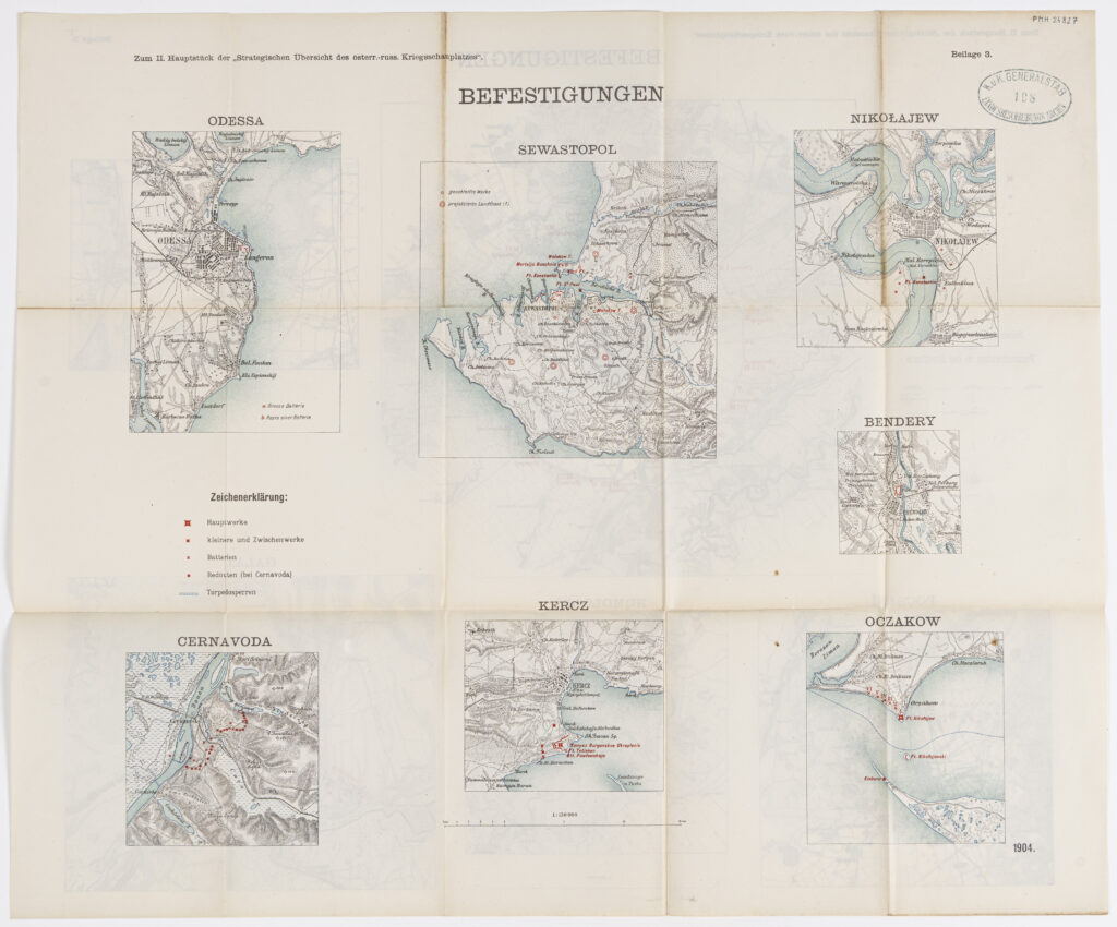
Paper, full colour print; from 51 x 61 cm to 50 x 72 cm; scale: 1:150,000, 1:200,000; u. r. ‘Zum II. Hauptstück der Strategischen Übersicht des österr.-ungar. – russ. Kriegsschauplatzes’; upper middle on individual plans: ‘BEFESTIGUNGEN.’, ‘Detail der wichtigsten Donaüubergangspunkte.’; u. r.: ‘Beilage 3.’, ‘Beilage 4/a.’, oval stamp: ‘K.u.K. GENERALSTAB / LANDESBESCHREIBUNGS ARCHIV’, both plans contain keys.
Found in the Museum
HPM/PMH-24827 – HPM/PMH-24828
Military plans with reduced depictions of fortresses on the Black Sea coast: ‘ODESSA’, ‘SEWASTOPOL’, ‘NIKOLAJEW’, ‘CERNAVODA’, ‘KERCZ’, ‘BENDERY’, ‘BUKAREST’, ‘COSMESTI’, ‘FOCSANI’, ‘NOMOLOASA’, ‘GALAZ’, and ‘OCZAKOW’, and major Danube river crossings: ‘Turnu Severin, Hinova’, ‘Calafatu, Vidin, Ciuperceni, Vidbol.’, ‘Lom Palanka.’, ‘Rahova.’, ‘Islas, Nikopol, Flamanda.’, ‘Brza Palanka.’, ‘Cibar Palanka.’, ‘Celeiu, Corabia, Selistiora.’, ‘Sistov – Zimnicea.’, ‘Giurgevo – Rusčuk.’, ‘Lotenita – Turukai.’, ‘Rasova, Cerna voda’; ‘Harsova.’, ‘Reni.’; ‘Silistria.’; ‘Isaccea.’; ‘Macin, Braila.’, and ‘Tulcea, Izmail.’

Military plans with reduced depictions of fortresses on the Black Sea coast: ‘ODESSA’, ‘SEWASTOPOL’, ‘NIKOLAJEW’, ‘CERNAVODA’, ‘KERCZ’, ‘BENDERY’, ‘BUKAREST’, ‘COSMESTI’, ‘FOCSANI’, ‘NOMOLOASA’, ‘GALAZ’, and ‘OCZAKOW’, and major Danube river crossings: ‘Turnu Severin, Hinova’, ‘Calafatu, Vidin, Ciuperceni, Vidbol.’, ‘Lom Palanka.’, ‘Rahova.’, ‘Islas, Nikopol, Flamanda.’, ‘Brza Palanka.’, ‘Cibar Palanka.’, ‘Celeiu, Corabia, Selistiora.’, ‘Sistov – Zimnicea.’, ‘Giurgevo – Rusčuk.’, ‘Lotenita – Turukai.’, ‘Rasova, Cerna voda’; ‘Harsova.’, ‘Reni.’; ‘Silistria.’; ‘Isaccea.’; ‘Macin, Braila.’, and ‘Tulcea, Izmail.’
Military plans with reduced depictions of fortresses on the Black Sea coast: ‘ODESSA’, ‘SEWASTOPOL’, ‘NIKOLAJEW’, ‘CERNAVODA’, ‘KERCZ’, ‘BENDERY’, ‘BUKAREST’, ‘COSMESTI’, ‘FOCSANI’, ‘NOMOLOASA’, ‘GALAZ’, and ‘OCZAKOW’, and major Danube river crossings: ‘Turnu Severin, Hinova’, ‘Calafatu, Vidin, Ciuperceni, Vidbol.’, ‘Lom Palanka.’, ‘Rahova.’, ‘Islas, Nikopol, Flamanda.’, ‘Brza Palanka.’, ‘Cibar Palanka.’, ‘Celeiu, Corabia, Selistiora.’, ‘Sistov – Zimnicea.’, ‘Giurgevo – Rusčuk.’, ‘Lotenita – Turukai.’, ‘Rasova, Cerna voda’; ‘Harsova.’, ‘Reni.’; ‘Silistria.’; ‘Isaccea.’; ‘Macin, Braila.’, and ‘Tulcea, Izmail.’
Military plans with reduced depictions of fortresses on the Black Sea coast: ‘ODESSA’, ‘SEWASTOPOL’, ‘NIKOLAJEW’, ‘CERNAVODA’, ‘KERCZ’, ‘BENDERY’, ‘BUKAREST’, ‘COSMESTI’, ‘FOCSANI’, ‘NOMOLOASA’, ‘GALAZ’, and ‘OCZAKOW’, and major Danube river crossings: ‘Turnu Severin, Hinova’, ‘Calafatu, Vidin, Ciuperceni, Vidbol.’, ‘Lom Palanka.’, ‘Rahova.’, ‘Islas, Nikopol, Flamanda.’, ‘Brza Palanka.’, ‘Cibar Palanka.’, ‘Celeiu, Corabia, Selistiora.’, ‘Sistov – Zimnicea.’, ‘Giurgevo – Rusčuk.’, ‘Lotenita – Turukai.’, ‘Rasova, Cerna voda’; ‘Harsova.’, ‘Reni.’; ‘Silistria.’; ‘Isaccea.’; ‘Macin, Braila.’, and ‘Tulcea, Izmail.’