Skip to content
CROATIAN HISTORY MUSEUM
Home
Introductory word
Editions
E-catalog
Contact
English
Hrvatski
Menu
Home
Introductory word
Editions
E-catalog
Contact
English
Hrvatski
Imperial and Royal Military Geographical Institute in Vienna
Military Geographical Institute in Belgrade
Timeline
1801
to
1981
Institute
All
Belgrade
Vienna
Type of material
All
Plans
Manuals
Atlas
Maps
Map type
All
Thematic
Topographic
Thematic
All
Administrative
Historical
Hunting maps
Traffic
War
Geographical designation
All
Beničanci
Bjelovar
Brinje
Čabar
Čakovec
Čazma
Čepin
Đakovo
Darda
Daruvar
Delnice
Donji Miholjac
Donji Žirovac
Dubrava
Dubrovnik
Dugi otok
Đurđevac
Erdut
Ervenik
Gornja Kovačica
Gospić
Gračac
Gradec
Hrvatska Kostajnica
Ilok
Jablanac
Jasenovac
Karlobag
Karlovac
Kloštar Ivanić
Kloštar Podravski
Knin
Koprivnica
Korenica
Kotoriba
Krapina
Križevci
Kutjevo
Ledenice
Lekenik
Makarska
Medak
Našice
Neum
Nova Gradiška
Novi Vinodolski
Novigrad
Ogulin
Omiš
Orahovica
Oriovac
Osijek
Oštarije
Otočac
otok Biševo
otok Cres
otok Korčula
otok Krk
otok Mljet
otok Pag
otok Rab
otok Silba
otok Sušac
otok Sveti Andrija
otok Vis
otok Žirje
Pakrac
Pazin
Petrinja
Pitomača
Plitvice
Požega
Pula
Rača
Rijeka
Rovinj
Rovišće
Samobor
Šandrovac
Šarengrad
Senj
Severin
Šibenik
Sisak
Slatina
Spišić Bukovica
Split
Stara Gradiška
Ston
Sunja
Sušak
Sveti Ivan Žabno
Sveti Rok
Topolovica
Topusko
Valpovo
Varaždin
Velika Gorica
Velika Pisanica
Veliki Grđevac
Veliko Trojstvo
Vinica
Vinkovci
Virovitica
Vis
Voćin
Vojnić
Vukovar
Zadar
Zagreb
Zlatar
Map
Topographic Map of Southeastern Bohemia
Map
Topographic Map of Central Bohemia
Map
Topographic Map of Northwest Bohemia
Map
Topographic Map of Northern Bohemia
Map
Relief Map of Mount Triglav
Map
Topographic Map of Laun and its Surroundings
Map
Topographic Map of the Jarosław and Przeworsk Area
Map
Topographic Map of the Hagenau and Landau Area
Map
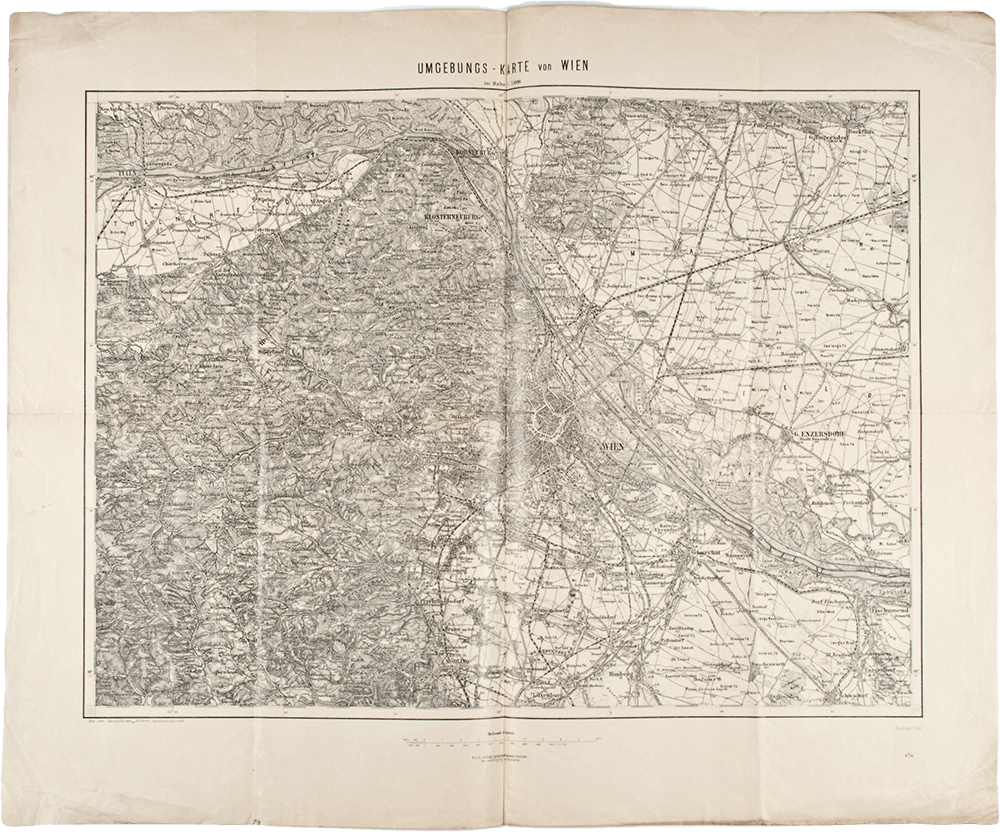
Topographic Map of the Surroundings of Vienna
Page
1
Page
2
Page
3
Page
4
Page
5
Page
6
Page
7
Page
8
Page
9
Page
10
Page
11
Page
12
Page
13
Page
14
Page
15
Page
16
Page
17
error:
Sadržaj je zaštićen!
Croatian History Museum