HRVATSKI POVIJESNI
MUZEJ

Editions

Introduction

The Cartographical Collection of the Croatian History Museum was established in 1980 as a separate museum collection housing the maps, plans, and atlases created from the 16th to the end of the 20th century. Until 1980, cartographical collections were part of other museum collections, such as the Painting, Graphic, and Sculpture Collection and Documentary Collection I, but also of the museum’s library fund. The largest part of the Collection, numbering more than 2,000 units, consists of maps of Croatian lands through history, showing historical processes and events, the history of borders and administrative-territorial organisation, and the economic and cultural development of Croatia.[1] Although the Cartographical Collection was formed in the 1980s, the ways of acquiring its materials can be traced to the time of the National Museum (1846). The maps became part of the museum holdings through purchases, donations, and handovers, and the Collection also includes maps whose provenance in the holdings is unknown. Based on the first inventory lists of the National Museum, the predecessor of the Croatian History Museum, it is apparent that, from the year of the museum’s founding, the maps were obtained from various European second-hand shops in Vienna, Leipzig, Lienz, Berlin, Prague, Frankfurt, etc. Further collection of cartographical materials for the needs of the museum’s holdings was done in a systematic and targeted manner, and this has continued through purchases and donations to this day, according to the mission and working guidelines of the national museum. A prominent part of the Collection are the cartographical materials depicting European and Croatian lands published by the former Imperial and Royal Military Geographical Institute in Vienna (K. u. K. Militärgeographisches Institut) and the Military Geographical Institute in Belgrade (today the ‘General Stevan Bošković’ Military Geographical Institute). This includes 1,134 cartographical depictions,[2] 815 of which are related to topographic and topical maps, plans, and one manual for the easier ‘reading and understanding’ of maps, entitled Übungsblätter für den Unterricht im Kartenlesen, published by the Imperial and Royal Military Geographical Institute in Vienna, while 317 topographic maps and two atlases were published by the Military Geographical Institute in Belgrade. Topographic maps, as a type of cartographical material published by the two mentioned institutes, are more prevalent in the Collection’s holdings compared to maps of other publishers (e.g. Artaria & Co., Freytag & Berndt, The Lavoslav Hartman Bookshop (Kugli & Deutsch), etc.), which has indirectly imposed the criteria of the selection, cataloguing, and presentation of the material. Furthermore, due to their number, but also because of the inconsistency in the different dimensions of topographic maps and the practicality of displaying them, they have been presented in virtual form. The editions of the mentioned publishers that are part of the Collection’s holdings were published from the early 19th century to the 1980s, and the activities of both institutes were focused on staying up to date on the development and application of the then newest techniques of topographic and cadastral map production. The mentioned progress is visible on the cartographical depictions of European and Croatian lands found in the Collection’s holdings. The work of the military geographical institutes contributed to the development and widespread use of topographic cartography, which was at first intended exclusively for military use, but in time also found application in the civilian sector. The diverse cartographical material published by the Military Geographical Institutes in Vienna and Belgrade gathered in the Collection testifies to the territorial, administrative, and political changes and the position of Croatia within various state and legal systems during the 19th and 20th centuries, from the Austro-Hungarian Monarchy to the Socialist Federal Republic of Yugoslavia. Even though the topographic and topical maps originate from two institutes, it is worth noting that the Collection also contains earlier examples by other publishers, thanks to which we can track the development of their typology. The oldest map from the Collection’s holdings is the administrative map of Italy, Carta amministrativa del Regno d’Italia co’ suoi stabilimenti politici, militari, civili e religiosi (inv. no. HPM/PMH-9582), dating from 1813 and published by the institute in Milan (the predecessor of the Imperial and Royal Military Geographical Institute), while the newest map is the topographic map depicting Sisak and the surrounding area, which dates from 1982 and was created by gluing together the sheets Sisak 1 and Sisak 2 (inv. no. HPM-102650) published by the Military Geographical Institute in Belgrade. The topographic and topical maps, plans, and atlases are presented as valuable material historical sources and testaments to certain temporal and spatial events on European and Croatian soil. This type of cartographical data was produced in lithography (sometimes full colour lithography), print, and/or full colour print. The maps of the Imperial and Royal Military Geographical Institute were published in German, with the exception of partial toponymic terminology in the language of the depicted area. The employees and surveyors of the Military Geographical Institute in Belgrade used the maps of the Viennese institute in German before they began conducting their own surveys and producing their own topographic maps; the Belgrade institute began printing its own cartographical depictions in Serbian from the beginning of the 20th century. The logotype of the Military Geographical Institute in Belgrade, which consists of an equilateral triangle containing the Earth and a telescope, has been printed on most cases of the larger topographic maps (e.g. the road map of the Socialist Federal Republic of Yugoslavia, inv. no. HPM-102634).


[1] Museum 1846. – 1996.: pp. 119–120.

[2] A part of the cartographical material from the Collection will be added to the e-catalogue after restoration.

Imperial and Royal Military Geographical Institute in Vienna

By the end of the Wars of the Holy League (1683–1699), most of the Croatian lands were liberated from Ottoman rule, including the territory of Croatia up to the Una river and south of Velebit, and Slavonia and most of Srijem. A large part of the liberated Croatian territory was integrated into the Military Border, an organised anti-Ottoman defensive system administered by the Court War Council, while smaller parts remained under the command of the Croatian ban (viceroy). In the mid-18th century, the Military Border lost its defensive function, and the Croatian nobility hoped that their estates would be returned to the authority of the Croatian Diet and ban. However, this did not happen, and the Military Border became a sort of huge, open-air Habsburg regimental barracks.[3] Despite the cessation of the Ottoman threat, certain territorial, social, and political changes were visible on the newly-liberated Croatian territory, such as border changes, devastation of old settlements, and settlement of foreign noble families (Odescalchi, Hilleprand Prandau, Eltz, etc.), which was encouraged by the Austrian authorities. This led to the weakening of the Croatian nobility and the growing of the centuries-long resistance towards Viennese absolutism. The area of the Croatian-Slavonian Military Border encompassed almost half of Croatia’s territory. Even though it was a constituent part of the Kingdom of Croatia and Slavonia, it remained outside the jurisdiction of the Croatian Diet/Parliament until 1873, when the demilitarisation process began; it was reunited with civilian Croatia in 1881.[4] In 1758, in the wake of the crises and wars that swept the Habsburg Monarchy during her reign, Empress Maria Theresa conducted a modernisation of the Austrian armed forces, establishing the Quartermaster General Staff (Generalquartiermeisterstab) of the Austrian army, under the command of Marshal Franz Moritz von Lacy (1725–1801). This was the first military institution that, among other things, was responsible for systematic production of topographic maps. Due to a series of conducted state, social, and educational reforms, such as the professionalisation of the army and introduction of military and art schools, the conditions were soon set down for conducting the first, or Josephinian, topographic survey of all the lands of the Habsburg Monarchy (1763–1787), named after the Holy Roman Emperor Joseph II.[5] The greater part of civilian Croatia and Slavonia and the Croatian-Slavonian Military Border were included in the survey of 1774–1785, while a survey of coastal Istria and Dalmatia was not performed.[6] With this first topographic survey, Austrian cartography made important gains and achieved enviable results in the field of world cartography, which it perfected in time by using new surveying methods and discovering quicker and more efficient printing technology, which eventually resulted in the production and reproduction of high quality geographical maps.  One of the best cartographical representations of the Croatian lands produced on the basis of the first topographic survey and kept in the Collection is the map of the Kingdom of Hungary and the military and civilian parts of Croatia and Slavonia entitled Mappa generalis regni Hungariae partiumque adnexarum Croatiae, Slavoniae et confiniorum militarium (inv. no. HPM/PMH-3895). The map was produced in Pest by the Hungarian cartographer and military engineer János Lipszky, with the help of Croat Mirko Danijel Bogdanić, in 1806. The Josephinian maps with topographic descriptions show the relief forms,  hydrographic network, vegetation, roads, settlements, toponyms, and administrative-territorial organisation in great detail, and were made according to the then system of measurement (a Zoll, or Viennese inch, represented 400 Wiener Klafter, or Viennese fathoms, which corresponds to the modern 1:28,800 scale). Due to the very comprehensive geodesic and cartographical effort put into them, the maps were considered a state and military secret until 1864. During the first topographic survey, the Austrian surveyors and engineers also worked on cadastral maps and plans of the landholdings of the Habsburg Monarchy, the so-called Josephinian cadastre. However, the cadastre did not encompass all Croatian lands, but only the area of the Croatian-Slavonian Military Border, Rijeka, and a part of the Littoral.[7] The application of new knowledge and techniques resulted in the further development of Austrian cartography, which is visible on the maps produced during the second topographic survey (1806–1869), called the Franciscan survey after Francis I, the Austrian and Holy Roman emperor. In 1856, a general map of the Austrian Empire, named General Karte des Oesterreichischen Kaiserstaates mit einem grossen Theile der angrenzenden Lӓnder (inv. no. HPM/PMH-9985–10003/a), was produced in Vienna by Josef von Scheda, the director of the Imperial and Royal Military Geographical Institute, based on the new topographic survey. Scheda’s map is considered one of the best cartographical depictions of the Austrian Empire’s lands in the 19th century. The second topographic survey is the most important for Croatia because it encompassed all the Croatian lands (Istria and the Croatian Littoral 1821–1824, Dalmatia 1851–1853, and Croatia, Slavonia, and the Military Border 1865–1869), which resulted in the creation of topographic map sheets depicting Croatian territory.[8] The Franciscan maps did not greatly differ from the maps based on the Josephinian survey, even though they were smaller in scale. The topographic maps of the first and second survey had a primarily military application. However, in 1810, the decision was made to allow them to be freely printed and published on the territory of the Habsburg Monarchy, which gave them a civilian importance.[9] Despite their gradual civilian application, the Franciscan and Josephinian maps were classified as a state and military secret until this status was revoked 1864, which led to them gaining an increasingly important role in the civilian sector.[10] The systematic cadastral survey of all Croatian lands with full insight into the state of the economy and infrastructure, and which resulted in the first Franciscan cadastre, was performed in stages, starting in 1818 (the area of Istria 1818–1822, Dalmatia 1823–1838, and civilian Croatia and Slavonia and the Croatian-Slavonian Military Border 1847–1877).[11] In addition, in this period, one can trace the history of the creation and activities of the Imperial and Royal Military Geographical Institute in Vienna. One can mention the year 1800, when the predecessor of the Military Geographical Institute—the Deposito della guerra (War Depository)—was established in Milan in northern Italy during the French administration. The mentioned institution worked on gathering, safeguarding, and producing maps. As mentioned above, the Collection’s holdings contain an administrative map of Italy from 1813 entitled Carta amministrativa del Regno d’ Italia co’ suoi stabilimenti politici, militari, civili e religiosi (inv. no. HPM/PMH-9582), published by the institute in Milan. After the decisions of the Congress of Vienna of 1815 and the numerous territorial changes in Europe, the interest of the Austrian authorities for the further development of the Milanese cartographical institution was apparent; it was renamed the Geographical Institute. In 1839, all of the cartographical equipment and material of the Milanese institute was transferred to Vienna, where it was merged with the newly-founded Imperial and Royal Military Geographical Institute (K. u. K. Militärgeographisches Institut).[12] 
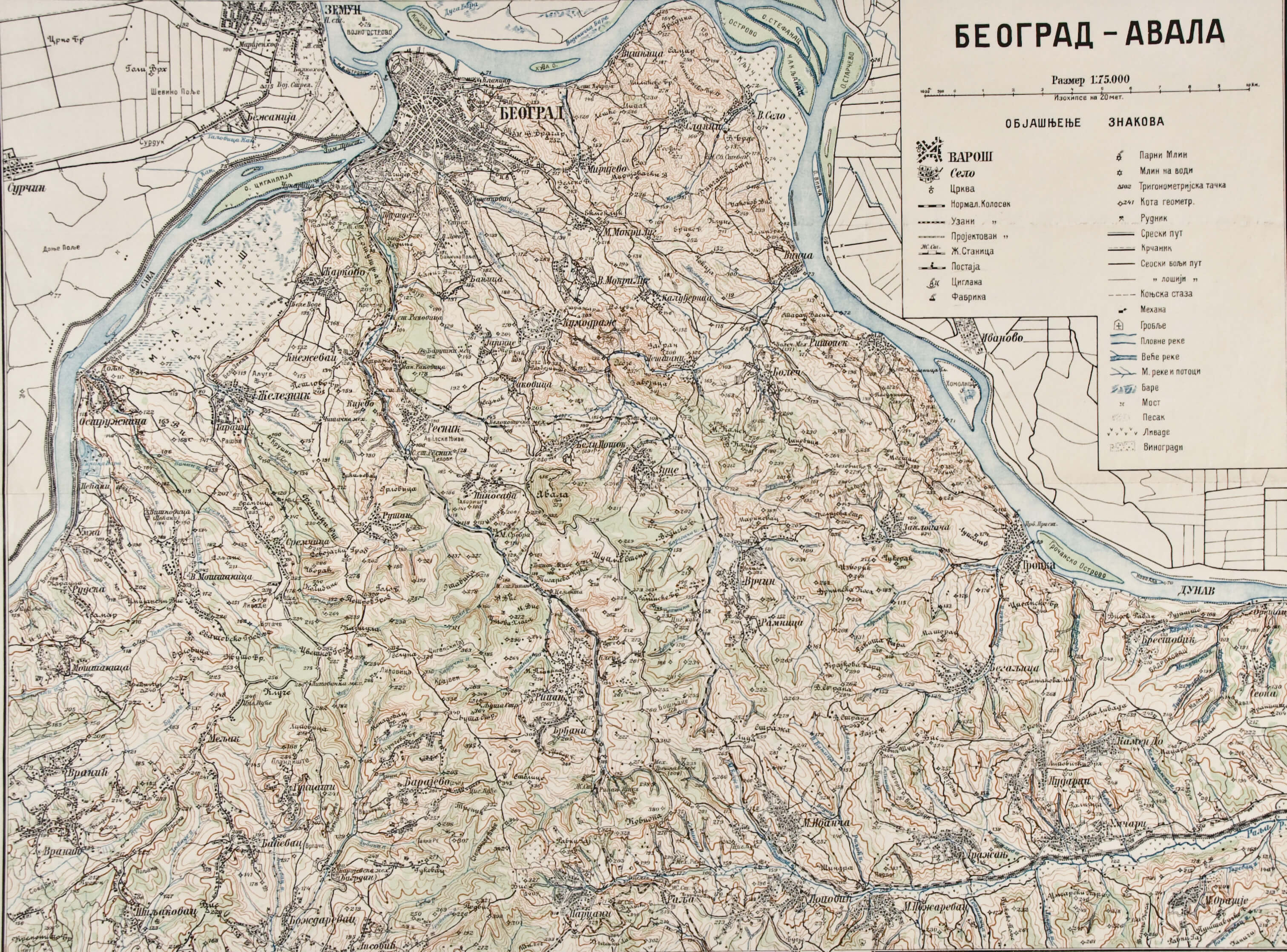
The work of the institute in Vienna was primarily focused on producing maps of the Habsburg/Austro-Hungarian Monarchy in various scales, among which a series of special maps[13] in the 1:75,000 scale, printed for military needs, holds a prominent place. The Imperial and Royal Military Geographical Institute changed its name to the Cartographical Institute after the collapse of the Austro-Hungarian Monarchy, and continued its work until just before the outbreak of World War II. In the late 19th century, the Austro-Hungarian Monarchy, as part of its territorial policy of expansion into the lands of southeastern Europe, secretly sent military cartographers into Bosnia and Herzegovina, tasking them with mapping the parts of Bosnia and Herzegovina that had not been depicted on topographic maps. After the Austro-Hungarian occupation of Bosnia and Herzegovina in 1878 and the annexation of 1908, when Bosnia and Herzegovina became an integral part of the Monarchy and its legal system, the surveying was performed with the goal of making an accurate a survey of the entire territory of Bosnia and Herzegovina.[14] The surveying and mapping of the mentioned territory were performed during the third, or Franz-Josephinian, topographic survey of all the lands of the Austro-Hungarian Monarchy (1869–1887), named after Austrian emperor Franz Joseph I. A larger number of maps made in the early 20th century depicting the Austro-Hungarian occupation of Bosnia and Herzegovina are kept in the Collection’s holdings, e.g. the maps entitled General – Karte / von / BOSNIEN UND DER HERCEGOVINA (HPM-101407 – HPM-101408). In addition, the maps and plans made after 1878 and showing the positions of the Austro-Hungarian army and capture of individual towns and cities of Bosnia and Herzegovina were inherited from the holdings of the former National Museum (inv. no. HPM/PMH-9628 – HPM/PMH-9646). One can mention that the cadastral plans of earlier surveys are still in use in Bosnia and Herzegovina, but also in certain parts of Serbia and Montenegro. The Collection’s holdings include a donated untitled topographic map produced during the third topographic survey, in 1885, depicting the area of Banal Croatia, from Mount Medvednica and Moslavačka Gora to Zrinska Gora and Petrova Gora (inv. no. HPM-102519), which used to be owned by the grandson of Metel Ožegović (1814–1890), a Croatian politician, baron, and member of the Revival movement, who stemmed from the Ožegović Barlabaševački family. The Franz-Josephinian maps were the first topographic maps also intended for the broader public, showing the entirety of Croatian territory, and whose individual sheets are still in use today.[15] Here one can highlight around ten plans depicting the battles of the Austro-Prussian War of 1866, e.g. the title Plan zu den gefechten bei Münchengrätz 28. Jun 1866. (inv. no. HPM/PMH-19732), a sizeable number of special maps produced on the basis of the third or Franz-Josephinian topographic survey that depict a part of Croatian territory (inv. no. HPM/PMH-5362 – HPM/PMH-5438), and a special map of the S. Dona di Piave area produced during the last Austro-Hungarian breakthrough across the Piave River in 1918 (inv. no. HPM/PMH-12578). Certain changes are visible on the Franz-Josephinian when compared to the Josephinian and Franciscan maps, such as the way the cartographical content is depicted as a whole, including a wealth of toponyms, or the depiction of relief (elevation differences).[16] In 1896, Austro-Hungarian Monarchy launched the fourth survey, or Beck’s Precise Survey, which was based on new geodetic and cartographical knowledge, but was left unfinished due to the outbreak of World War I. [17] Examining the Collection’s documentation and inventory books, one can see that much cartographical material of the Imperial and Royal Military Geographical Institute in Vienna was purchased, which attests to the position and role of the Croatian lands during their centuries-long shared territorial, state, and cultural history. These are mostly purchases of special maps with certain sheets showing Croatian territory, printed in the late 19th and early 20th centuries, and also present is the cartographical material from the time of World War I. One can also mention the plan of Doberdò di Lago (inv. no. HPM/PMH-15900), depicting the Italian front on the Isozno river and the defensive positions of the V Isonzo Army under the command of General Svetozar Borojević from autumn 1915, and the overview map showing the distribution of military units in the area of the XIII Zagreb Corps through 1918, entitled Übersichtkarte über die Dislokations und Unterkunftsverhällnisse der Truppen im Militӓrkommandobereiche Zagreb (inv. no. HPM/PMH-15877). Twenty printed sections of a special (topographic) map of the Austro-Hungarian Monarchy from the World War I period with a depiction of the area of Galicia and Bukovina were donated to the Croatian History Museum by Home Guard officer Ivan Henneberg, a participant of World War I (inv. no. HPM-83733 – HPM/PMH-83752). The Documentary Collection I of the Croatian History Museum contains, among the broader legacy of Vladimir Horvat, four topographic maps with sheets pertaining to the Isonzo Front, entitled Trient, Rovereto-Riva, and Gorizia (inv. no. HPM/PMH-22383 – HPM/PMH-22386). With the end of World War I and the collapse of the Austro-Hungarian Monarchy in 1918, a significant number of cartographical depictions were handed over to the National Museum by the demobilised 16th Imperial and Royal Infantry Regiment. Here one can highlight the more significant maps, such as several volumes of general maps of central Europe with varying numbers of sheets entitled General Karte von Central Europa (inv. no. HPM/PMH-9670 – HPM/PMH-9692, HPM/PMH-9693 – HPM/PMH-9715, HPM/PMH-9716 – HPM/PMH-9738, HPM/PMH-9739 – HPM/PMH-9761, HPM/PMH-9762 – HPM/PMH-9782, HPM/PMH-9783 – HPM/PMH-9798, HPM/PMH-9799 – HPM/PMH-9818, HPM/PMH-9819 – HPM/PMH-9841, HPM/PMH-9842 – HPM/PMH-9853/a, HPM/PMH-9872 – HPM/PMH-9896/a, HPM/PMH-10004 – HPM/PMH-10031) and the general map of the Austrian Empire, General Karte des Oesterreichischen Kaiserstaates mit einem grossen Theile der angrenzenden Lӓnder, by Joseph von Scheda (inv. no. HPM/PMH-9985 – HPM/PMH-10003/a).  


[3] Buczynski: 1997, pp. 9, 15–16; Hrvatski povijesni atlas: 2018, p. 198.

[4] Pandžić: 1988, p. 20; Vojna krajina, http://www.enciklopedija.hr/Natuknica.aspx?ID=65199 (12 March 2021).

[5] Frangeš: 2012, p. 29.

[6] Ibid., pp. 32, 37.<

[7] Pahernik: 2012, pp. 20, 23; Frangeš: 2012, pp. 30, 32–37, 48.

[8] Frangeš: 2012, p. 41.

[9] Marković: 1993, p. 306.

[10] Frangeš: 2012, p. 32.

[11] Frangeš: 2012, pp. 44–46.

[12] Frangeš: 2012., 40; Almer: 2008., 77‒79.

[13] Another term for topographic maps in the 1:75,000 scale.

[14] Marković: 1993, pp. 341–342, 346.

[15] Frangeš: 2012, p. 47.

[16] Lapaine, Tunjić, Frančula: 1997, p. 56.

[17] Frangeš: 2012, p. 47.


Military Geographical Institute in Belgrade

The Military Geographical Institute in Belgrade was founded in 1920 as the successor of the Topographic Section of the High Command, which had been active from 1876. With the end of World War I and the disintegration of the Austro-Hungarian Monarchy and the formation of a common South Slavic state on 1 December 1918 (the Kingdom of Serbs, Croats and Slovenes), the Military Geographical Institute in Belgrade took on the leading role in the development and application of new geodesic and cartographical knowledge in the new state union.[18] Due to political, social, and territorial changes, geodetic survey officers from Croatia, Slovenia, and Bosnia and Herzegovina who were employed at the Imperial and Royal Military Geographical Institute until 1918 were transferred to the Military Geographical Institute in Belgrade. The new institute’s work was oriented towards field recordings and conducting topographic surveys of the entire South Slavic state, which eventually resulted in the creation and printing of topographic maps, primarily of military, but later also civilian, significance. The topographic maps published by the Imperial and Royal Military Geographical Institute in Vienna served as the basic material for the surveyors’ and engineers’ efforts to create new topographic maps.[19] Several cartographical depictions published by the Military Geographical Institute in Belgrade were purchased for the needs of the Collection’s holdings. Of these, one can highlight the map of the Kingdom of Serbs, Croats and Slovenes entitled Vojno-teritorijalna podjela Kraljevine SHS, which shows the military-administrative division into 33 districts (inv. no. HPM/PMH-15882). The new borders of military districts in Croatia did not take into account the former administrative borders from the Austro-Hungarian period. Namely, certain Croatian lands that used to be part of the Triune Kingdom of Croatia, Slavonia and Dalmatia until 1918 were annexed to other districts, and thus the mentioned map testifies to a break in the continuity of Croatian historical provinces and lands.[20] A larger number of topographic maps of various scales (1:50,000, 1:100,000, 1:200,000, 1:300,000, and 1:500,000), produced from the interwar period to the 1980s, with sheets showing Croatian territory in the South Slavic state, form a significant part of the Collection’s holdings. One should also mention a number of topical maps published by the Belgrade institute, such as the reproduced road map of the Kingdom of Yugoslavia from 1939, entitled Karta automobilskih puteva Kraljevine Jugoslavije (inv. no. HPM/PMH-22881). The purchased cartographical material showing the period during and immediately after the end of World War II [21] includes two notable atlases: Istoriski atlas oslobodilačkog rata naroda Jugoslavije 1941. – 1945., which depicts the events of the People’s Liberation War on the territory of Yugoslavia, and the French language atlas Cartes sur la structure ethnique de la Marche (inv. no. HPM-33349), which shows the ethnic structure of the Julian March and was produced for the Paris Peace Conference in 1946, for the needs of the demarcation negotiations between Italy and the Federal People’s Republic of Yugoslavia. This atlas used to be the property of Vladimir Bakarić. After World War II, cartographical activity intensified, and civilian cartographical institutes were established outside the Military Geographical Institute. Two such institutions were Učila in Zagreb (1946) and Geokarte in Belgrade (1947).[22] In time, cartographical activity also spread to higher education and research institutions, such as the cartographical institutes of the Universities of Ljubljana and Zagreb, which published general, topical, and school maps, and the Yugoslav Institute of Lexicography, which published its own editions of large-scale atlases and maps.[23] In time, approximately one hundred donated topographic map sheets of various scales (from 1:50,000 to 1:500,000), printed from the mid-20th century and published by the Military Geographical institute in Belgrade, became part of the Collection. The donated cartographical material also includes an overview road map of the Socialist Federal Republic of Yugoslavia in 1:500,000 scale with a detailed depiction of the 1974 road network, entitled Karta SFRJ (inv. no. HPM-102634), plus an overview topographic map of Yugoslavia consisting of several sheets with marked state borders, administrative-territorial organisation, traffic infrastructure network, and cultural-historical heritage locations. The mentioned map used to be kept in the Yugoslav People’s Army V Military District Command, headquartered in Zagreb (inv. no. HPM-102632).


[18] Ibid, p. 59.p>

[19] Ibid, p. 59.p>

[20] Boban: 1992, pp. 23–24; Matković: 1999, pp. 106–107.

[21] After World War II, certain cartographical materials were inherited from the holdings of the former War Archive and Museum of the Independent State of Croatia; cartographical material relevant to the People’s Liberation War became part of the holdings of the former People’s Liberation of Croatia Museum (later the Revolution of the Peoples of Croatia Museum) according to the then policy and special instructions, the ‘Instructions for Collecting Material from the People’s Liberation Struggle for the People’s Liberation Museum’, Zagreb, 1945.

[22] The Collection’s holdings also include general maps of the Federal People’s Republic of Yugoslavia and the Socialist Federal Republic of Yugoslavia, such as the maps Federativna Narodna Republika Jugoslavija (inv. no. HPM-32370) and Socialistična Federativna Republika Jugoslavija (inv. no. HPM-93715) published by the Zagreb company Učila. Along with the mentioned overview maps, the company also published historical maps of the Croatian lands at the time before the arrival of the Croats, the time of the rulers of ‘Croatian blood’, the 19th century (until 1918), and the 20th century (after 1918), entitled Hrvatska prije doseljenja Hrvata, Hrvatska u doba narodnih vladara, Hrvatska u kasnom srednjem vijeku, Hrvatska u XIX. stoljeću (do 1918.), and Hrvatska u XX. stoljeću (poslije 1918. godine), respectively. These were authored by Dr Josip Lučić (inv. no. HPM-102987–102991).

[23] Frangeš: 2012, p. 91; Puceković: 2014, p. 33.


Conclusion

The Cartographical Collection of the Croatian History Museum holds over 1,000 topographic and topical maps printed from the early 19th to the late 20th centuries, published by two prominent cartographical institutions of central and southeastern Europe, the Imperial and Royal Military Geographical Institute in Vienna and the Military Geographical Institute in Belgrade. The presented cartographical material is of great cultural historical as well as national significance, because it directly attests to the territorial, administrative, and cultural changes on the Croatian lands and territory in the mentioned period.

The national history museum’s policy of collecting cartographical material attests to the mentioned development and integration processes of the Croatian territory and lands, and is based on the principles of purchase and donation. Therefore, the cartographical editions of the mentioned institutes were collected systematically and in a targeted manner. As a consequence of the numerous political changes in Croatia in the 20th century, which resulted in the collapse of entire state systems (the Austro-Hungarian Monarchy, the State of Slovenes, Croats and Serbs, the Kingdom of Serbs, Croats and Slovenes, the Kingdom of Yugoslavia, the Independent State of Croatia, Democratic Federal Yugoslavia, the Federal People’s Republic of Yugoslavia, and the Socialist Federal Republic of Yugoslavia), the material created by the institutes in Vienna and Belgrade also became part of the Cartographical Collection of the Croatian History Museum.

The first e-catalogue, entitled The Maps of Military Geographical Institutes in the Croatian History Museum, presents previously unpublished cartographical material of the military geographical institutes in Vienna and Belgrade from the holdings of the Cartographical Collection, which contribute to the historical valorisation and significance of this type of cartographical material. The selected topographic and topical maps, plans, and atlases presented in this catalogue shall surely also ennoble the first permanent display of the Croatian History Museum.

Sources, Bibliography, and Literature

  • Almer, Franz: ‘Das k.u.k. militärgeographische Institut’, Comm. in Asteroseismology, 149, Graz, 2008, pp. 76–82.
  • Bakrač, Saša T.; Radojčić, Stevan; Sekulović, Dragoljub: ‘140 godina Vojnogeografskog instituta – društveno-političke, vojne i profesionalne okolnosti postojanja’, Vojno delo, 68 (7), 2016, pp. 393–411.
  • Boban, Ljubo: Hrvatske granice od 1918. do 1991. godine, Školska knjiga: Hrvatska akademija znanosti i umjetnosti, Zagreb, 1992.
  • Borošak Marijanović, Jelena (ed.): Dadoh zlato za željezo: Prvi svjetski rat u zbirkama Hrvatskog povijesnog muzeja:  exhibition catalogue, Hrvatski povijesni muzej, Zagreb, 2011.
  • Brstilo Rešetar, Matea; Nevešćanin, Ivica; Smetko, Andreja (eds.): 1918. prijelomna godina u Hrvatskoj, katalog izložbe, Hrvatski povijesni muzej, Zagreb, 2018.
  • Buczynski, Alexander: Gradovi Vojne krajine, Hrvatski institut za povijest, Zagreb, 1997.
  • Collectio Felbar, URL: http://www.felbar.com/hr/home (12 March 2021)
  • ‘Custoza’. Hrvatska enciklopedija, mrežno izdanje. Leksikografski zavod Miroslav Krleža, 2020, URL: http://www.enciklopedija.hr/Natuknica.aspx?ID=13019 (9 April 2021)
  • Dugački, Vlatka; Regan, Krešimir (eds.): Hrvatski povijesni atlas, Leksikografski zavod Miroslav Krleža, Zagreb, 2018.
  • Filipović, Ratimir: Bosna i Hercegovine na geografskim kartama od prvih početaka do kraja XIX vijeka, Akademija nauka i umjetnosti Bosne i Hercegovine, Sarajevo 1970.
  • Frančula, Nedjeljko; Lapaine, Miljenko; Jazbec Ivo-Pavao: Kartografski rječnik, Hrvatsko kartografsko društvo: Naklada Dominović, Zagreb, 2020.
  • Frangeš,  Stanislav (ed.): Topografske karte na području Hrvatske, Državna geodetska uprava, Zagreb, 2012.
  • ‘Galicija’. Hrvatska enciklopedija, mrežno izdanje. Leksikografski zavod Miroslav Krleža, 2021. URL: http://www.enciklopedija.hr/Natuknica.aspx?ID=21072 (4 May 2021)
  • Houška, Mladen; Mačković, Romana: XIII. zagrebački korpus u I. svjetskom ratu: exhibition catalogue, Sv. Ivan Zelina: Muzej Sveti Ivan Zelina, 2014.
  • ‘Istorijatʼ, Vojnogeografski institut „general Stevan Bošković“, http://www.vgi.mod.gov.rs/lat/209/istorijat-209 (20 May 2021)
  • ‘karta’, Hrvatska enciklopedija, mrežno izdanje. Leksikografski zavod Miroslav Krleža, URL: https://www.enciklopedija.hr/Natuknica.aspx?ID=30670 (22 March 2021)
  • Lapaine, Miljenko, Tunjić Ivka, Frančula Nedjeljko: ‘Hrvatski kartografi u doba starih izmjera na području uže Hrvatske i Slavonije’, Geodetski list, 1, 1997, pp. 53‒71.
  • ‘Londonski memorandum (Memorandum o suglasnosti između vlada Italije, Ujedinjenoga Kraljevstva, Sjedinjenih Američkih Država i Jugoslavije o Slobodnom Teritoriju Trsta)’, Istarska enciklopedija. Leksikografski zavod Miroslav Krleža, URL: http://istra.lzmk.hr/clanak.aspx?id=1563  (22 March 2021)
  • Marjanić, Danijela: ‘Svetozar Borojević od Bojne – zapovjednik austrougarskih postrojbi na Jugozapadnom (talijanskom) bojištu u Prvom svjetskom ratu 1915. – 1918.’, Fontes, 21, 2015, pp. 51–68.
  • Marković, Mirko: Descriptio Bosnae & Hercegovinae: Bosna i Hercegovina na starim zemljovidima, AGM, Zagreb, 1998.
  • Marković, Mirko: Descriptio Croatiae: Hrvatske zemlje na geografskim kartama od najstarijih vremena do pojave prvih topografskih karata, Naprijed, Zagreb, 1993.
  • Matković, Hrvoje: Suvremena politička povijest Hrvatske, Ministarstvo unutarnjih poslova Republike Hrvatske: Policijska akademija, Zagreb, 1999.
  • Militär-Almanach und Schematismus 1791–1914, URL: https://library.hungaricana.hu/hu/collection/austrian_state_archives_MilitarAlmanachSchematismus/ (22 April 2021)
  • ‘Osimski sporazumi’, Istarska enciklopedija. Leksikografski zavod Miroslav Krleža, URL: http://istra.lzmk.hr/clanak.aspx?id=1972 (22 March 2021)
  • Pahernik, Mladen: Vojna topografija I-topografski objekti zemljišta, Ministarstvo obrane Republike Hrvatske; Oružane snage Republike Hrvatske; Hrvatsko vojno učilište ‘Petar Zrinski’, Zagreb, 2012.
  • Pet stoljeća zemljopisnih karata Hrvatske (15. – 19. stoljeće), exhibition catalogue, Povijesni muzej Hrvatske, Zagreb, 1998.
  • Prusko-austrijski rat 1866.’, Hrvatska enciklopedija, mrežno izdanje. Leksikografski zavod Miroslav Krleža, URL: http://www.enciklopedija.hr/Natuknica.aspx?ID=50864 (19 April 2021)
  • Puceković, Branko: ‘Ispitivanje točnosti Topografske karte u mjerilu 1:25 000 u izdanju Vojnogeografskog instituta u Beogradu’, Geodetski list, 68 (91), 1, Zagreb, 2014, pp. 33–46.
  • ‘Revolucija 1848 – 1849.’, Proleksis enciklopedija, mrežno izdanje. Leksikografski zavod Miroslav Krleža, URL: https://proleksis.lzmk.hr/43840/ (19 April 2021)
  • ‘Risorgimento’, Hrvatska enciklopedija, mrežno izdanje. Leksikografski zavod Miroslav Krleža, URL: http://www.enciklopedija.hr/Natuknica.aspx?ID=52981 (9 April 2021)
  • ‘Sighet’, Holocaust Encyclopedia. United States Holocaust Memorial Museum, URL: https://encyclopedia.ushmm.org/content/en/article/sighet (4 June 2021)
  • ‘Slobodni Teritorij Trsta (STT)’, Istarska enciklopedija. Leksikografski zavod Miroslav Krleža, URL: http://istra.lzmk.hr/clanak.aspx?id=2523 (22 March 2021)
  • Slukan Altić, Mirela: Povijesna kartografija: kartografski izvori u povijesnim znanostima, Meridijani, Samobor, 2003.
  • Slukan Altić, Mirela: ‘Povijest županijskog upravno-teritorijalnog ustroja Bjelovarko-bilogorske županije’, Radovi Zavoda za znanstvenoistraživački rad i umjetnički rad u Bjelovaru, 2, 2008, pp. 9–33.
  • Škiljan, Maja (ed.): Museum 1846. – 1996., exhibition catalogue,  Hrvatski povijesni muzej, Zagreb, 1996.
  • Tominac, Nikola: ‘Ličani u okupaciji Bosne i Hercegovine 1878. godine’, Hercegovina: časopis za kultrurno i povijesno nasljeđe, 6, 2020, pp. 233–270.
  • Topoljak, Jusuf; Lapaine, Miljenko; Tuno, Nedim; Mulahusić, Admir: ‘Analiza vanjskih elemenata sadržaja katastarskih planova stare izmjere Bosne i Hercegovine’, Geodetski list, 1, 2017, pp. 55–76.
  • Valentić, Mirko (ed.): Hrvatska na tajnim zemljovidima 18. i 19. stoljeća 1: Gradiška pukovnija, Hrvatski institut za povijest, Zagreb, 1999.
  • Vasiljević, Slavko S.; Amović, Mladen Z.; Višnjić, Radenko I.: ‘Katastarski planovi prema podjeli bečkog vojnogeografskog instituta’, Vještak – časopis iz oblasti i teorije i prakse vještačenja, 2 (2), 2016, pp. 219–223.
  • ‘Vojna krajina’, Hrvatska enciklopedija, mrežno izdanje. Leksikografski zavod Miroslav Krleža, 2021, URL: http://www.enciklopedija.hr/Natuknica.aspx?ID=65199 (12 March 2021)
  • Župan, Robert: Vojna topografska karta mjerila 1:25 000, magistarski rad, Sveučilište u Zagrebu Geodetski fakultet, Zagreb, 2003.
error: Sadržaj je zaštićen!

Hrvatski povijesni muzej