Container: cardboard, glued; map, paper on canvas, print; 130,3 × 110,8 cm; ; scale: 1:500,000; u. l.: map title: ‘CARTA AMMINISTRATIVA / DEL REGNO D' ITALIA / CO' SUOI STABILIMENTI / POLITICI, MILITARI, CIVILI, E RELIGIOSI; / E CON UNA PARTE DEGLI STATI LIMITROFI.’; note on publisher, year of publication, and engraver below title: ‘Costrutta nel' Deposito della Guerra / PER ORDINE DEL MINISTRO DELLA GUERRA E MARINA / NELL' ANNO MDCCCXI. / Aggiunta e corretta nell' anno 1813. / La presente Carta e stata incisa sotto la vigilanza del Sigr. G. Bordigo, Capo Incisere nel Deposito della Guerra’; right of title: warning about corrected and retouched map sheets from 1831, brief overview with survey and statistical data (size of territory and population) and map key; l. l.: statistical data on the Kingdom of Italy; scales expressed in Italian and French miles and kilometres along lower map edge
Received from the 16th Imperial and Royal Varaždin Infantry Regiment
HPM/PMH-9582
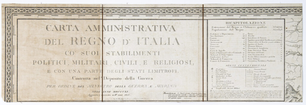
Administrative map of Italy with statistical data according to regions for political, military, religious, judicial, school, economic, and maritime institutions, also showing parts of the neighbouring countries. The map was printed at the request of the Italian Ministry of War and the Navy in 1811, and corrected and revised editions were printed in 1813 and 1831. After his conquest of Italy, Napoleon Bonaparte founded the Deposito della Guerra (War Depository) in Milan in 1800. It was an institution dedicated to collecting, preserving, and publishing maps, and remained active under another name (Geographical Institute) until 1839, when all of its cartographical equipment and materials were transferred to Vienna and merged with the newly-established Imperial and Royal Military Geographical Institute (K. u. K. Militärgeographisches Institut). The materials and equipment were transferred under the leadership of the Institute’s director, Major Anton Campana (1776–1841), through Splügenpass (Italian: Passo dello Spluga) on the Italian-Swiss border (altitude: 2,113 m). Horse carts, 17 officers, and 29 civilian Institute staff transported 16 tons of equipment. Due to various complications, the journey from Milan to Vienna lasted 22 days and covered 120 Austrian miles, or around 910 km.

Administrative map of Italy with statistical data according to regions for political, military, religious, judicial, school, economic, and maritime institutions, also showing parts of the neighbouring countries. The map was printed at the request of the Italian Ministry of War and the Navy in 1811, and corrected and revised editions were printed in 1813 and 1831. After his conquest of Italy, Napoleon Bonaparte founded the Deposito della Guerra (War Depository) in Milan in 1800. It was an institution dedicated to collecting, preserving, and publishing maps, and remained active under another name (Geographical Institute) until 1839, when all of its cartographical equipment and materials were transferred to Vienna and merged with the newly-established Imperial and Royal Military Geographical Institute (K. u. K. Militärgeographisches Institut). The materials and equipment were transferred under the leadership of the Institute’s director, Major Anton Campana (1776–1841), through Splügenpass (Italian: Passo dello Spluga) on the Italian-Swiss border (altitude: 2,113 m). Horse carts, 17 officers, and 29 civilian Institute staff transported 16 tons of equipment. Due to various complications, the journey from Milan to Vienna lasted 22 days and covered 120 Austrian miles, or around 910 km.
Administrative map of Italy with statistical data according to regions for political, military, religious, judicial, school, economic, and maritime institutions, also showing parts of the neighbouring countries. The map was printed at the request of the Italian Ministry of War and the Navy in 1811, and corrected and revised editions were printed in 1813 and 1831. After his conquest of Italy, Napoleon Bonaparte founded the Deposito della Guerra (War Depository) in Milan in 1800. It was an institution dedicated to collecting, preserving, and publishing maps, and remained active under another name (Geographical Institute) until 1839, when all of its cartographical equipment and materials were transferred to Vienna and merged with the newly-established Imperial and Royal Military Geographical Institute (K. u. K. Militärgeographisches Institut). The materials and equipment were transferred under the leadership of the Institute’s director, Major Anton Campana (1776–1841), through Splügenpass (Italian: Passo dello Spluga) on the Italian-Swiss border (altitude: 2,113 m). Horse carts, 17 officers, and 29 civilian Institute staff transported 16 tons of equipment. Due to various complications, the journey from Milan to Vienna lasted 22 days and covered 120 Austrian miles, or around 910 km.
Administrative map of Italy with statistical data according to regions for political, military, religious, judicial, school, economic, and maritime institutions, also showing parts of the neighbouring countries. The map was printed at the request of the Italian Ministry of War and the Navy in 1811, and corrected and revised editions were printed in 1813 and 1831. After his conquest of Italy, Napoleon Bonaparte founded the Deposito della Guerra (War Depository) in Milan in 1800. It was an institution dedicated to collecting, preserving, and publishing maps, and remained active under another name (Geographical Institute) until 1839, when all of its cartographical equipment and materials were transferred to Vienna and merged with the newly-established Imperial and Royal Military Geographical Institute (K. u. K. Militärgeographisches Institut). The materials and equipment were transferred under the leadership of the Institute’s director, Major Anton Campana (1776–1841), through Splügenpass (Italian: Passo dello Spluga) on the Italian-Swiss border (altitude: 2,113 m). Horse carts, 17 officers, and 29 civilian Institute staff transported 16 tons of equipment. Due to various complications, the journey from Milan to Vienna lasted 22 days and covered 120 Austrian miles, or around 910 km.
Administrative map of Italy with statistical data according to regions for political, military, religious, judicial, school, economic, and maritime institutions, also showing parts of the neighbouring countries. The map was printed at the request of the Italian Ministry of War and the Navy in 1811, and corrected and revised editions were printed in 1813 and 1831. After his conquest of Italy, Napoleon Bonaparte founded the Deposito della Guerra (War Depository) in Milan in 1800. It was an institution dedicated to collecting, preserving, and publishing maps, and remained active under another name (Geographical Institute) until 1839, when all of its cartographical equipment and materials were transferred to Vienna and merged with the newly-established Imperial and Royal Military Geographical Institute (K. u. K. Militärgeographisches Institut). The materials and equipment were transferred under the leadership of the Institute’s director, Major Anton Campana (1776–1841), through Splügenpass (Italian: Passo dello Spluga) on the Italian-Swiss border (altitude: 2,113 m). Horse carts, 17 officers, and 29 civilian Institute staff transported 16 tons of equipment. Due to various complications, the journey from Milan to Vienna lasted 22 days and covered 120 Austrian miles, or around 910 km.
Administrative map of Italy with statistical data according to regions for political, military, religious, judicial, school, economic, and maritime institutions, also showing parts of the neighbouring countries. The map was printed at the request of the Italian Ministry of War and the Navy in 1811, and corrected and revised editions were printed in 1813 and 1831. After his conquest of Italy, Napoleon Bonaparte founded the Deposito della Guerra (War Depository) in Milan in 1800. It was an institution dedicated to collecting, preserving, and publishing maps, and remained active under another name (Geographical Institute) until 1839, when all of its cartographical equipment and materials were transferred to Vienna and merged with the newly-established Imperial and Royal Military Geographical Institute (K. u. K. Militärgeographisches Institut). The materials and equipment were transferred under the leadership of the Institute’s director, Major Anton Campana (1776–1841), through Splügenpass (Italian: Passo dello Spluga) on the Italian-Swiss border (altitude: 2,113 m). Horse carts, 17 officers, and 29 civilian Institute staff transported 16 tons of equipment. Due to various complications, the journey from Milan to Vienna lasted 22 days and covered 120 Austrian miles, or around 910 km.
Administrative map of Italy with statistical data according to regions for political, military, religious, judicial, school, economic, and maritime institutions, also showing parts of the neighbouring countries. The map was printed at the request of the Italian Ministry of War and the Navy in 1811, and corrected and revised editions were printed in 1813 and 1831. After his conquest of Italy, Napoleon Bonaparte founded the Deposito della Guerra (War Depository) in Milan in 1800. It was an institution dedicated to collecting, preserving, and publishing maps, and remained active under another name (Geographical Institute) until 1839, when all of its cartographical equipment and materials were transferred to Vienna and merged with the newly-established Imperial and Royal Military Geographical Institute (K. u. K. Militärgeographisches Institut). The materials and equipment were transferred under the leadership of the Institute’s director, Major Anton Campana (1776–1841), through Splügenpass (Italian: Passo dello Spluga) on the Italian-Swiss border (altitude: 2,113 m). Horse carts, 17 officers, and 29 civilian Institute staff transported 16 tons of equipment. Due to various complications, the journey from Milan to Vienna lasted 22 days and covered 120 Austrian miles, or around 910 km.
Administrative map of Italy with statistical data according to regions for political, military, religious, judicial, school, economic, and maritime institutions, also showing parts of the neighbouring countries. The map was printed at the request of the Italian Ministry of War and the Navy in 1811, and corrected and revised editions were printed in 1813 and 1831. After his conquest of Italy, Napoleon Bonaparte founded the Deposito della Guerra (War Depository) in Milan in 1800. It was an institution dedicated to collecting, preserving, and publishing maps, and remained active under another name (Geographical Institute) until 1839, when all of its cartographical equipment and materials were transferred to Vienna and merged with the newly-established Imperial and Royal Military Geographical Institute (K. u. K. Militärgeographisches Institut). The materials and equipment were transferred under the leadership of the Institute’s director, Major Anton Campana (1776–1841), through Splügenpass (Italian: Passo dello Spluga) on the Italian-Swiss border (altitude: 2,113 m). Horse carts, 17 officers, and 29 civilian Institute staff transported 16 tons of equipment. Due to various complications, the journey from Milan to Vienna lasted 22 days and covered 120 Austrian miles, or around 910 km.