Paper on canvas, full colour print; 35.5 x 39 cm; scale: 1:75,000; l. r.: ‘Cena 1.20 DIN.’; l. r. on individual sheets: information about mapmakers; l. l. on individual sheets: dates of modifications through 1898
Inherited from the War Museum and Archive of the Independent State of Croatia
HPM/PMH-24831/a-b, HPM/PMH-24833/b – HPM/PMH-24854
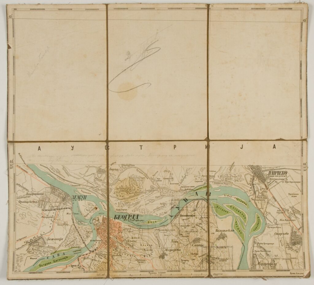
The first military map of the Kingdom of Serbia is among the most important maps of Serbian cartography, printed for the needs of the Serbian army’s General Staff. The production of the map, which consists of 94 sheets, began in 1881, during topographic surveys of the terrain. The last map sheet was printed in 1895. Individual maps that are today kept in the Cartographical Collection of the Croatian History Museum include: ‘D 1. Belgrade’, ‘D 2. Avala’, ‘K 10. Daščani Kladenac’, ‘D 3. Sopot’, ‘V 2. Šabac’, ‘G 2. Obrenovac’, ‘D 6. Kraljevo’, ‘G 6. Arilje’, ‘A 5. V. Stolac’, ‘V 6. Užice’, ‘J 7. Knjaževac’, ‘E 6. Čukojevac’, ‘B 2. Cer’, ‘Crnča’, ‘J 11. Vlasina’, ‘V 7. Murtenica’, ‘B 5. Bajina Bašta’, ‘Ž 10. Podujevo’, ‘K 5. Rajac’, ‘K 6. Tri Kladenca’, ‘Ž 9. Kuršumlija’, ‘E 9. Pilatovići’, and ‘B 7. Uvac’.

The first military map of the Kingdom of Serbia is among the most important maps of Serbian cartography, printed for the needs of the Serbian army’s General Staff. The production of the map, which consists of 94 sheets, began in 1881, during topographic surveys of the terrain. The last map sheet was printed in 1895. Individual maps that are today kept in the Cartographical Collection of the Croatian History Museum include: ‘D 1. Belgrade’, ‘D 2. Avala’, ‘K 10. Daščani Kladenac’, ‘D 3. Sopot’, ‘V 2. Šabac’, ‘G 2. Obrenovac’, ‘D 6. Kraljevo’, ‘G 6. Arilje’, ‘A 5. V. Stolac’, ‘V 6. Užice’, ‘J 7. Knjaževac’, ‘E 6. Čukojevac’, ‘B 2. Cer’, ‘Crnča’, ‘J 11. Vlasina’, ‘V 7. Murtenica’, ‘B 5. Bajina Bašta’, ‘Ž 10. Podujevo’, ‘K 5. Rajac’, ‘K 6. Tri Kladenca’, ‘Ž 9. Kuršumlija’, ‘E 9. Pilatovići’, and ‘B 7. Uvac’.
The first military map of the Kingdom of Serbia is among the most important maps of Serbian cartography, printed for the needs of the Serbian army’s General Staff. The production of the map, which consists of 94 sheets, began in 1881, during topographic surveys of the terrain. The last map sheet was printed in 1895. Individual maps that are today kept in the Cartographical Collection of the Croatian History Museum include: ‘D 1. Belgrade’, ‘D 2. Avala’, ‘K 10. Daščani Kladenac’, ‘D 3. Sopot’, ‘V 2. Šabac’, ‘G 2. Obrenovac’, ‘D 6. Kraljevo’, ‘G 6. Arilje’, ‘A 5. V. Stolac’, ‘V 6. Užice’, ‘J 7. Knjaževac’, ‘E 6. Čukojevac’, ‘B 2. Cer’, ‘Crnča’, ‘J 11. Vlasina’, ‘V 7. Murtenica’, ‘B 5. Bajina Bašta’, ‘Ž 10. Podujevo’, ‘K 5. Rajac’, ‘K 6. Tri Kladenca’, ‘Ž 9. Kuršumlija’, ‘E 9. Pilatovići’, and ‘B 7. Uvac’.
The first military map of the Kingdom of Serbia is among the most important maps of Serbian cartography, printed for the needs of the Serbian army’s General Staff. The production of the map, which consists of 94 sheets, began in 1881, during topographic surveys of the terrain. The last map sheet was printed in 1895. Individual maps that are today kept in the Cartographical Collection of the Croatian History Museum include: ‘D 1. Belgrade’, ‘D 2. Avala’, ‘K 10. Daščani Kladenac’, ‘D 3. Sopot’, ‘V 2. Šabac’, ‘G 2. Obrenovac’, ‘D 6. Kraljevo’, ‘G 6. Arilje’, ‘A 5. V. Stolac’, ‘V 6. Užice’, ‘J 7. Knjaževac’, ‘E 6. Čukojevac’, ‘B 2. Cer’, ‘Crnča’, ‘J 11. Vlasina’, ‘V 7. Murtenica’, ‘B 5. Bajina Bašta’, ‘Ž 10. Podujevo’, ‘K 5. Rajac’, ‘K 6. Tri Kladenca’, ‘Ž 9. Kuršumlija’, ‘E 9. Pilatovići’, and ‘B 7. Uvac’.
The first military map of the Kingdom of Serbia is among the most important maps of Serbian cartography, printed for the needs of the Serbian army’s General Staff. The production of the map, which consists of 94 sheets, began in 1881, during topographic surveys of the terrain. The last map sheet was printed in 1895. Individual maps that are today kept in the Cartographical Collection of the Croatian History Museum include: ‘D 1. Belgrade’, ‘D 2. Avala’, ‘K 10. Daščani Kladenac’, ‘D 3. Sopot’, ‘V 2. Šabac’, ‘G 2. Obrenovac’, ‘D 6. Kraljevo’, ‘G 6. Arilje’, ‘A 5. V. Stolac’, ‘V 6. Užice’, ‘J 7. Knjaževac’, ‘E 6. Čukojevac’, ‘B 2. Cer’, ‘Crnča’, ‘J 11. Vlasina’, ‘V 7. Murtenica’, ‘B 5. Bajina Bašta’, ‘Ž 10. Podujevo’, ‘K 5. Rajac’, ‘K 6. Tri Kladenca’, ‘Ž 9. Kuršumlija’, ‘E 9. Pilatovići’, and ‘B 7. Uvac’.
The first military map of the Kingdom of Serbia is among the most important maps of Serbian cartography, printed for the needs of the Serbian army’s General Staff. The production of the map, which consists of 94 sheets, began in 1881, during topographic surveys of the terrain. The last map sheet was printed in 1895. Individual maps that are today kept in the Cartographical Collection of the Croatian History Museum include: ‘D 1. Belgrade’, ‘D 2. Avala’, ‘K 10. Daščani Kladenac’, ‘D 3. Sopot’, ‘V 2. Šabac’, ‘G 2. Obrenovac’, ‘D 6. Kraljevo’, ‘G 6. Arilje’, ‘A 5. V. Stolac’, ‘V 6. Užice’, ‘J 7. Knjaževac’, ‘E 6. Čukojevac’, ‘B 2. Cer’, ‘Crnča’, ‘J 11. Vlasina’, ‘V 7. Murtenica’, ‘B 5. Bajina Bašta’, ‘Ž 10. Podujevo’, ‘K 5. Rajac’, ‘K 6. Tri Kladenca’, ‘Ž 9. Kuršumlija’, ‘E 9. Pilatovići’, and ‘B 7. Uvac’.
The first military map of the Kingdom of Serbia is among the most important maps of Serbian cartography, printed for the needs of the Serbian army’s General Staff. The production of the map, which consists of 94 sheets, began in 1881, during topographic surveys of the terrain. The last map sheet was printed in 1895. Individual maps that are today kept in the Cartographical Collection of the Croatian History Museum include: ‘D 1. Belgrade’, ‘D 2. Avala’, ‘K 10. Daščani Kladenac’, ‘D 3. Sopot’, ‘V 2. Šabac’, ‘G 2. Obrenovac’, ‘D 6. Kraljevo’, ‘G 6. Arilje’, ‘A 5. V. Stolac’, ‘V 6. Užice’, ‘J 7. Knjaževac’, ‘E 6. Čukojevac’, ‘B 2. Cer’, ‘Crnča’, ‘J 11. Vlasina’, ‘V 7. Murtenica’, ‘B 5. Bajina Bašta’, ‘Ž 10. Podujevo’, ‘K 5. Rajac’, ‘K 6. Tri Kladenca’, ‘Ž 9. Kuršumlija’, ‘E 9. Pilatovići’, and ‘B 7. Uvac’.
The first military map of the Kingdom of Serbia is among the most important maps of Serbian cartography, printed for the needs of the Serbian army’s General Staff. The production of the map, which consists of 94 sheets, began in 1881, during topographic surveys of the terrain. The last map sheet was printed in 1895. Individual maps that are today kept in the Cartographical Collection of the Croatian History Museum include: ‘D 1. Belgrade’, ‘D 2. Avala’, ‘K 10. Daščani Kladenac’, ‘D 3. Sopot’, ‘V 2. Šabac’, ‘G 2. Obrenovac’, ‘D 6. Kraljevo’, ‘G 6. Arilje’, ‘A 5. V. Stolac’, ‘V 6. Užice’, ‘J 7. Knjaževac’, ‘E 6. Čukojevac’, ‘B 2. Cer’, ‘Crnča’, ‘J 11. Vlasina’, ‘V 7. Murtenica’, ‘B 5. Bajina Bašta’, ‘Ž 10. Podujevo’, ‘K 5. Rajac’, ‘K 6. Tri Kladenca’, ‘Ž 9. Kuršumlija’, ‘E 9. Pilatovići’, and ‘B 7. Uvac’.
The first military map of the Kingdom of Serbia is among the most important maps of Serbian cartography, printed for the needs of the Serbian army’s General Staff. The production of the map, which consists of 94 sheets, began in 1881, during topographic surveys of the terrain. The last map sheet was printed in 1895. Individual maps that are today kept in the Cartographical Collection of the Croatian History Museum include: ‘D 1. Belgrade’, ‘D 2. Avala’, ‘K 10. Daščani Kladenac’, ‘D 3. Sopot’, ‘V 2. Šabac’, ‘G 2. Obrenovac’, ‘D 6. Kraljevo’, ‘G 6. Arilje’, ‘A 5. V. Stolac’, ‘V 6. Užice’, ‘J 7. Knjaževac’, ‘E 6. Čukojevac’, ‘B 2. Cer’, ‘Crnča’, ‘J 11. Vlasina’, ‘V 7. Murtenica’, ‘B 5. Bajina Bašta’, ‘Ž 10. Podujevo’, ‘K 5. Rajac’, ‘K 6. Tri Kladenca’, ‘Ž 9. Kuršumlija’, ‘E 9. Pilatovići’, and ‘B 7. Uvac’.
The first military map of the Kingdom of Serbia is among the most important maps of Serbian cartography, printed for the needs of the Serbian army’s General Staff. The production of the map, which consists of 94 sheets, began in 1881, during topographic surveys of the terrain. The last map sheet was printed in 1895. Individual maps that are today kept in the Cartographical Collection of the Croatian History Museum include: ‘D 1. Belgrade’, ‘D 2. Avala’, ‘K 10. Daščani Kladenac’, ‘D 3. Sopot’, ‘V 2. Šabac’, ‘G 2. Obrenovac’, ‘D 6. Kraljevo’, ‘G 6. Arilje’, ‘A 5. V. Stolac’, ‘V 6. Užice’, ‘J 7. Knjaževac’, ‘E 6. Čukojevac’, ‘B 2. Cer’, ‘Crnča’, ‘J 11. Vlasina’, ‘V 7. Murtenica’, ‘B 5. Bajina Bašta’, ‘Ž 10. Podujevo’, ‘K 5. Rajac’, ‘K 6. Tri Kladenca’, ‘Ž 9. Kuršumlija’, ‘E 9. Pilatovići’, and ‘B 7. Uvac’.
The first military map of the Kingdom of Serbia is among the most important maps of Serbian cartography, printed for the needs of the Serbian army’s General Staff. The production of the map, which consists of 94 sheets, began in 1881, during topographic surveys of the terrain. The last map sheet was printed in 1895. Individual maps that are today kept in the Cartographical Collection of the Croatian History Museum include: ‘D 1. Belgrade’, ‘D 2. Avala’, ‘K 10. Daščani Kladenac’, ‘D 3. Sopot’, ‘V 2. Šabac’, ‘G 2. Obrenovac’, ‘D 6. Kraljevo’, ‘G 6. Arilje’, ‘A 5. V. Stolac’, ‘V 6. Užice’, ‘J 7. Knjaževac’, ‘E 6. Čukojevac’, ‘B 2. Cer’, ‘Crnča’, ‘J 11. Vlasina’, ‘V 7. Murtenica’, ‘B 5. Bajina Bašta’, ‘Ž 10. Podujevo’, ‘K 5. Rajac’, ‘K 6. Tri Kladenca’, ‘Ž 9. Kuršumlija’, ‘E 9. Pilatovići’, and ‘B 7. Uvac’.
The first military map of the Kingdom of Serbia is among the most important maps of Serbian cartography, printed for the needs of the Serbian army’s General Staff. The production of the map, which consists of 94 sheets, began in 1881, during topographic surveys of the terrain. The last map sheet was printed in 1895. Individual maps that are today kept in the Cartographical Collection of the Croatian History Museum include: ‘D 1. Belgrade’, ‘D 2. Avala’, ‘K 10. Daščani Kladenac’, ‘D 3. Sopot’, ‘V 2. Šabac’, ‘G 2. Obrenovac’, ‘D 6. Kraljevo’, ‘G 6. Arilje’, ‘A 5. V. Stolac’, ‘V 6. Užice’, ‘J 7. Knjaževac’, ‘E 6. Čukojevac’, ‘B 2. Cer’, ‘Crnča’, ‘J 11. Vlasina’, ‘V 7. Murtenica’, ‘B 5. Bajina Bašta’, ‘Ž 10. Podujevo’, ‘K 5. Rajac’, ‘K 6. Tri Kladenca’, ‘Ž 9. Kuršumlija’, ‘E 9. Pilatovići’, and ‘B 7. Uvac’.
The first military map of the Kingdom of Serbia is among the most important maps of Serbian cartography, printed for the needs of the Serbian army’s General Staff. The production of the map, which consists of 94 sheets, began in 1881, during topographic surveys of the terrain. The last map sheet was printed in 1895. Individual maps that are today kept in the Cartographical Collection of the Croatian History Museum include: ‘D 1. Belgrade’, ‘D 2. Avala’, ‘K 10. Daščani Kladenac’, ‘D 3. Sopot’, ‘V 2. Šabac’, ‘G 2. Obrenovac’, ‘D 6. Kraljevo’, ‘G 6. Arilje’, ‘A 5. V. Stolac’, ‘V 6. Užice’, ‘J 7. Knjaževac’, ‘E 6. Čukojevac’, ‘B 2. Cer’, ‘Crnča’, ‘J 11. Vlasina’, ‘V 7. Murtenica’, ‘B 5. Bajina Bašta’, ‘Ž 10. Podujevo’, ‘K 5. Rajac’, ‘K 6. Tri Kladenca’, ‘Ž 9. Kuršumlija’, ‘E 9. Pilatovići’, and ‘B 7. Uvac’.
The first military map of the Kingdom of Serbia is among the most important maps of Serbian cartography, printed for the needs of the Serbian army’s General Staff. The production of the map, which consists of 94 sheets, began in 1881, during topographic surveys of the terrain. The last map sheet was printed in 1895. Individual maps that are today kept in the Cartographical Collection of the Croatian History Museum include: ‘D 1. Belgrade’, ‘D 2. Avala’, ‘K 10. Daščani Kladenac’, ‘D 3. Sopot’, ‘V 2. Šabac’, ‘G 2. Obrenovac’, ‘D 6. Kraljevo’, ‘G 6. Arilje’, ‘A 5. V. Stolac’, ‘V 6. Užice’, ‘J 7. Knjaževac’, ‘E 6. Čukojevac’, ‘B 2. Cer’, ‘Crnča’, ‘J 11. Vlasina’, ‘V 7. Murtenica’, ‘B 5. Bajina Bašta’, ‘Ž 10. Podujevo’, ‘K 5. Rajac’, ‘K 6. Tri Kladenca’, ‘Ž 9. Kuršumlija’, ‘E 9. Pilatovići’, and ‘B 7. Uvac’.
The first military map of the Kingdom of Serbia is among the most important maps of Serbian cartography, printed for the needs of the Serbian army’s General Staff. The production of the map, which consists of 94 sheets, began in 1881, during topographic surveys of the terrain. The last map sheet was printed in 1895. Individual maps that are today kept in the Cartographical Collection of the Croatian History Museum include: ‘D 1. Belgrade’, ‘D 2. Avala’, ‘K 10. Daščani Kladenac’, ‘D 3. Sopot’, ‘V 2. Šabac’, ‘G 2. Obrenovac’, ‘D 6. Kraljevo’, ‘G 6. Arilje’, ‘A 5. V. Stolac’, ‘V 6. Užice’, ‘J 7. Knjaževac’, ‘E 6. Čukojevac’, ‘B 2. Cer’, ‘Crnča’, ‘J 11. Vlasina’, ‘V 7. Murtenica’, ‘B 5. Bajina Bašta’, ‘Ž 10. Podujevo’, ‘K 5. Rajac’, ‘K 6. Tri Kladenca’, ‘Ž 9. Kuršumlija’, ‘E 9. Pilatovići’, and ‘B 7. Uvac’.
The first military map of the Kingdom of Serbia is among the most important maps of Serbian cartography, printed for the needs of the Serbian army’s General Staff. The production of the map, which consists of 94 sheets, began in 1881, during topographic surveys of the terrain. The last map sheet was printed in 1895. Individual maps that are today kept in the Cartographical Collection of the Croatian History Museum include: ‘D 1. Belgrade’, ‘D 2. Avala’, ‘K 10. Daščani Kladenac’, ‘D 3. Sopot’, ‘V 2. Šabac’, ‘G 2. Obrenovac’, ‘D 6. Kraljevo’, ‘G 6. Arilje’, ‘A 5. V. Stolac’, ‘V 6. Užice’, ‘J 7. Knjaževac’, ‘E 6. Čukojevac’, ‘B 2. Cer’, ‘Crnča’, ‘J 11. Vlasina’, ‘V 7. Murtenica’, ‘B 5. Bajina Bašta’, ‘Ž 10. Podujevo’, ‘K 5. Rajac’, ‘K 6. Tri Kladenca’, ‘Ž 9. Kuršumlija’, ‘E 9. Pilatovići’, and ‘B 7. Uvac’.
The first military map of the Kingdom of Serbia is among the most important maps of Serbian cartography, printed for the needs of the Serbian army’s General Staff. The production of the map, which consists of 94 sheets, began in 1881, during topographic surveys of the terrain. The last map sheet was printed in 1895. Individual maps that are today kept in the Cartographical Collection of the Croatian History Museum include: ‘D 1. Belgrade’, ‘D 2. Avala’, ‘K 10. Daščani Kladenac’, ‘D 3. Sopot’, ‘V 2. Šabac’, ‘G 2. Obrenovac’, ‘D 6. Kraljevo’, ‘G 6. Arilje’, ‘A 5. V. Stolac’, ‘V 6. Užice’, ‘J 7. Knjaževac’, ‘E 6. Čukojevac’, ‘B 2. Cer’, ‘Crnča’, ‘J 11. Vlasina’, ‘V 7. Murtenica’, ‘B 5. Bajina Bašta’, ‘Ž 10. Podujevo’, ‘K 5. Rajac’, ‘K 6. Tri Kladenca’, ‘Ž 9. Kuršumlija’, ‘E 9. Pilatovići’, and ‘B 7. Uvac’.
The first military map of the Kingdom of Serbia is among the most important maps of Serbian cartography, printed for the needs of the Serbian army’s General Staff. The production of the map, which consists of 94 sheets, began in 1881, during topographic surveys of the terrain. The last map sheet was printed in 1895. Individual maps that are today kept in the Cartographical Collection of the Croatian History Museum include: ‘D 1. Belgrade’, ‘D 2. Avala’, ‘K 10. Daščani Kladenac’, ‘D 3. Sopot’, ‘V 2. Šabac’, ‘G 2. Obrenovac’, ‘D 6. Kraljevo’, ‘G 6. Arilje’, ‘A 5. V. Stolac’, ‘V 6. Užice’, ‘J 7. Knjaževac’, ‘E 6. Čukojevac’, ‘B 2. Cer’, ‘Crnča’, ‘J 11. Vlasina’, ‘V 7. Murtenica’, ‘B 5. Bajina Bašta’, ‘Ž 10. Podujevo’, ‘K 5. Rajac’, ‘K 6. Tri Kladenca’, ‘Ž 9. Kuršumlija’, ‘E 9. Pilatovići’, and ‘B 7. Uvac’.
The first military map of the Kingdom of Serbia is among the most important maps of Serbian cartography, printed for the needs of the Serbian army’s General Staff. The production of the map, which consists of 94 sheets, began in 1881, during topographic surveys of the terrain. The last map sheet was printed in 1895. Individual maps that are today kept in the Cartographical Collection of the Croatian History Museum include: ‘D 1. Belgrade’, ‘D 2. Avala’, ‘K 10. Daščani Kladenac’, ‘D 3. Sopot’, ‘V 2. Šabac’, ‘G 2. Obrenovac’, ‘D 6. Kraljevo’, ‘G 6. Arilje’, ‘A 5. V. Stolac’, ‘V 6. Užice’, ‘J 7. Knjaževac’, ‘E 6. Čukojevac’, ‘B 2. Cer’, ‘Crnča’, ‘J 11. Vlasina’, ‘V 7. Murtenica’, ‘B 5. Bajina Bašta’, ‘Ž 10. Podujevo’, ‘K 5. Rajac’, ‘K 6. Tri Kladenca’, ‘Ž 9. Kuršumlija’, ‘E 9. Pilatovići’, and ‘B 7. Uvac’.
The first military map of the Kingdom of Serbia is among the most important maps of Serbian cartography, printed for the needs of the Serbian army’s General Staff. The production of the map, which consists of 94 sheets, began in 1881, during topographic surveys of the terrain. The last map sheet was printed in 1895. Individual maps that are today kept in the Cartographical Collection of the Croatian History Museum include: ‘D 1. Belgrade’, ‘D 2. Avala’, ‘K 10. Daščani Kladenac’, ‘D 3. Sopot’, ‘V 2. Šabac’, ‘G 2. Obrenovac’, ‘D 6. Kraljevo’, ‘G 6. Arilje’, ‘A 5. V. Stolac’, ‘V 6. Užice’, ‘J 7. Knjaževac’, ‘E 6. Čukojevac’, ‘B 2. Cer’, ‘Crnča’, ‘J 11. Vlasina’, ‘V 7. Murtenica’, ‘B 5. Bajina Bašta’, ‘Ž 10. Podujevo’, ‘K 5. Rajac’, ‘K 6. Tri Kladenca’, ‘Ž 9. Kuršumlija’, ‘E 9. Pilatovići’, and ‘B 7. Uvac’.
The first military map of the Kingdom of Serbia is among the most important maps of Serbian cartography, printed for the needs of the Serbian army’s General Staff. The production of the map, which consists of 94 sheets, began in 1881, during topographic surveys of the terrain. The last map sheet was printed in 1895. Individual maps that are today kept in the Cartographical Collection of the Croatian History Museum include: ‘D 1. Belgrade’, ‘D 2. Avala’, ‘K 10. Daščani Kladenac’, ‘D 3. Sopot’, ‘V 2. Šabac’, ‘G 2. Obrenovac’, ‘D 6. Kraljevo’, ‘G 6. Arilje’, ‘A 5. V. Stolac’, ‘V 6. Užice’, ‘J 7. Knjaževac’, ‘E 6. Čukojevac’, ‘B 2. Cer’, ‘Crnča’, ‘J 11. Vlasina’, ‘V 7. Murtenica’, ‘B 5. Bajina Bašta’, ‘Ž 10. Podujevo’, ‘K 5. Rajac’, ‘K 6. Tri Kladenca’, ‘Ž 9. Kuršumlija’, ‘E 9. Pilatovići’, and ‘B 7. Uvac’.
The first military map of the Kingdom of Serbia is among the most important maps of Serbian cartography, printed for the needs of the Serbian army’s General Staff. The production of the map, which consists of 94 sheets, began in 1881, during topographic surveys of the terrain. The last map sheet was printed in 1895. Individual maps that are today kept in the Cartographical Collection of the Croatian History Museum include: ‘D 1. Belgrade’, ‘D 2. Avala’, ‘K 10. Daščani Kladenac’, ‘D 3. Sopot’, ‘V 2. Šabac’, ‘G 2. Obrenovac’, ‘D 6. Kraljevo’, ‘G 6. Arilje’, ‘A 5. V. Stolac’, ‘V 6. Užice’, ‘J 7. Knjaževac’, ‘E 6. Čukojevac’, ‘B 2. Cer’, ‘Crnča’, ‘J 11. Vlasina’, ‘V 7. Murtenica’, ‘B 5. Bajina Bašta’, ‘Ž 10. Podujevo’, ‘K 5. Rajac’, ‘K 6. Tri Kladenca’, ‘Ž 9. Kuršumlija’, ‘E 9. Pilatovići’, and ‘B 7. Uvac’.
The first military map of the Kingdom of Serbia is among the most important maps of Serbian cartography, printed for the needs of the Serbian army’s General Staff. The production of the map, which consists of 94 sheets, began in 1881, during topographic surveys of the terrain. The last map sheet was printed in 1895. Individual maps that are today kept in the Cartographical Collection of the Croatian History Museum include: ‘D 1. Belgrade’, ‘D 2. Avala’, ‘K 10. Daščani Kladenac’, ‘D 3. Sopot’, ‘V 2. Šabac’, ‘G 2. Obrenovac’, ‘D 6. Kraljevo’, ‘G 6. Arilje’, ‘A 5. V. Stolac’, ‘V 6. Užice’, ‘J 7. Knjaževac’, ‘E 6. Čukojevac’, ‘B 2. Cer’, ‘Crnča’, ‘J 11. Vlasina’, ‘V 7. Murtenica’, ‘B 5. Bajina Bašta’, ‘Ž 10. Podujevo’, ‘K 5. Rajac’, ‘K 6. Tri Kladenca’, ‘Ž 9. Kuršumlija’, ‘E 9. Pilatovići’, and ‘B 7. Uvac’.
The first military map of the Kingdom of Serbia is among the most important maps of Serbian cartography, printed for the needs of the Serbian army’s General Staff. The production of the map, which consists of 94 sheets, began in 1881, during topographic surveys of the terrain. The last map sheet was printed in 1895. Individual maps that are today kept in the Cartographical Collection of the Croatian History Museum include: ‘D 1. Belgrade’, ‘D 2. Avala’, ‘K 10. Daščani Kladenac’, ‘D 3. Sopot’, ‘V 2. Šabac’, ‘G 2. Obrenovac’, ‘D 6. Kraljevo’, ‘G 6. Arilje’, ‘A 5. V. Stolac’, ‘V 6. Užice’, ‘J 7. Knjaževac’, ‘E 6. Čukojevac’, ‘B 2. Cer’, ‘Crnča’, ‘J 11. Vlasina’, ‘V 7. Murtenica’, ‘B 5. Bajina Bašta’, ‘Ž 10. Podujevo’, ‘K 5. Rajac’, ‘K 6. Tri Kladenca’, ‘Ž 9. Kuršumlija’, ‘E 9. Pilatovići’, and ‘B 7. Uvac’.
The first military map of the Kingdom of Serbia is among the most important maps of Serbian cartography, printed for the needs of the Serbian army’s General Staff. The production of the map, which consists of 94 sheets, began in 1881, during topographic surveys of the terrain. The last map sheet was printed in 1895. Individual maps that are today kept in the Cartographical Collection of the Croatian History Museum include: ‘D 1. Belgrade’, ‘D 2. Avala’, ‘K 10. Daščani Kladenac’, ‘D 3. Sopot’, ‘V 2. Šabac’, ‘G 2. Obrenovac’, ‘D 6. Kraljevo’, ‘G 6. Arilje’, ‘A 5. V. Stolac’, ‘V 6. Užice’, ‘J 7. Knjaževac’, ‘E 6. Čukojevac’, ‘B 2. Cer’, ‘Crnča’, ‘J 11. Vlasina’, ‘V 7. Murtenica’, ‘B 5. Bajina Bašta’, ‘Ž 10. Podujevo’, ‘K 5. Rajac’, ‘K 6. Tri Kladenca’, ‘Ž 9. Kuršumlija’, ‘E 9. Pilatovići’, and ‘B 7. Uvac’.
The first military map of the Kingdom of Serbia is among the most important maps of Serbian cartography, printed for the needs of the Serbian army’s General Staff. The production of the map, which consists of 94 sheets, began in 1881, during topographic surveys of the terrain. The last map sheet was printed in 1895. Individual maps that are today kept in the Cartographical Collection of the Croatian History Museum include: ‘D 1. Belgrade’, ‘D 2. Avala’, ‘K 10. Daščani Kladenac’, ‘D 3. Sopot’, ‘V 2. Šabac’, ‘G 2. Obrenovac’, ‘D 6. Kraljevo’, ‘G 6. Arilje’, ‘A 5. V. Stolac’, ‘V 6. Užice’, ‘J 7. Knjaževac’, ‘E 6. Čukojevac’, ‘B 2. Cer’, ‘Crnča’, ‘J 11. Vlasina’, ‘V 7. Murtenica’, ‘B 5. Bajina Bašta’, ‘Ž 10. Podujevo’, ‘K 5. Rajac’, ‘K 6. Tri Kladenca’, ‘Ž 9. Kuršumlija’, ‘E 9. Pilatovići’, and ‘B 7. Uvac’.
The first military map of the Kingdom of Serbia is among the most important maps of Serbian cartography, printed for the needs of the Serbian army’s General Staff. The production of the map, which consists of 94 sheets, began in 1881, during topographic surveys of the terrain. The last map sheet was printed in 1895. Individual maps that are today kept in the Cartographical Collection of the Croatian History Museum include: ‘D 1. Belgrade’, ‘D 2. Avala’, ‘K 10. Daščani Kladenac’, ‘D 3. Sopot’, ‘V 2. Šabac’, ‘G 2. Obrenovac’, ‘D 6. Kraljevo’, ‘G 6. Arilje’, ‘A 5. V. Stolac’, ‘V 6. Užice’, ‘J 7. Knjaževac’, ‘E 6. Čukojevac’, ‘B 2. Cer’, ‘Crnča’, ‘J 11. Vlasina’, ‘V 7. Murtenica’, ‘B 5. Bajina Bašta’, ‘Ž 10. Podujevo’, ‘K 5. Rajac’, ‘K 6. Tri Kladenca’, ‘Ž 9. Kuršumlija’, ‘E 9. Pilatovići’, and ‘B 7. Uvac’.
The first military map of the Kingdom of Serbia is among the most important maps of Serbian cartography, printed for the needs of the Serbian army’s General Staff. The production of the map, which consists of 94 sheets, began in 1881, during topographic surveys of the terrain. The last map sheet was printed in 1895. Individual maps that are today kept in the Cartographical Collection of the Croatian History Museum include: ‘D 1. Belgrade’, ‘D 2. Avala’, ‘K 10. Daščani Kladenac’, ‘D 3. Sopot’, ‘V 2. Šabac’, ‘G 2. Obrenovac’, ‘D 6. Kraljevo’, ‘G 6. Arilje’, ‘A 5. V. Stolac’, ‘V 6. Užice’, ‘J 7. Knjaževac’, ‘E 6. Čukojevac’, ‘B 2. Cer’, ‘Crnča’, ‘J 11. Vlasina’, ‘V 7. Murtenica’, ‘B 5. Bajina Bašta’, ‘Ž 10. Podujevo’, ‘K 5. Rajac’, ‘K 6. Tri Kladenca’, ‘Ž 9. Kuršumlija’, ‘E 9. Pilatovići’, and ‘B 7. Uvac’.
The first military map of the Kingdom of Serbia is among the most important maps of Serbian cartography, printed for the needs of the Serbian army’s General Staff. The production of the map, which consists of 94 sheets, began in 1881, during topographic surveys of the terrain. The last map sheet was printed in 1895. Individual maps that are today kept in the Cartographical Collection of the Croatian History Museum include: ‘D 1. Belgrade’, ‘D 2. Avala’, ‘K 10. Daščani Kladenac’, ‘D 3. Sopot’, ‘V 2. Šabac’, ‘G 2. Obrenovac’, ‘D 6. Kraljevo’, ‘G 6. Arilje’, ‘A 5. V. Stolac’, ‘V 6. Užice’, ‘J 7. Knjaževac’, ‘E 6. Čukojevac’, ‘B 2. Cer’, ‘Crnča’, ‘J 11. Vlasina’, ‘V 7. Murtenica’, ‘B 5. Bajina Bašta’, ‘Ž 10. Podujevo’, ‘K 5. Rajac’, ‘K 6. Tri Kladenca’, ‘Ž 9. Kuršumlija’, ‘E 9. Pilatovići’, and ‘B 7. Uvac’.
The first military map of the Kingdom of Serbia is among the most important maps of Serbian cartography, printed for the needs of the Serbian army’s General Staff. The production of the map, which consists of 94 sheets, began in 1881, during topographic surveys of the terrain. The last map sheet was printed in 1895. Individual maps that are today kept in the Cartographical Collection of the Croatian History Museum include: ‘D 1. Belgrade’, ‘D 2. Avala’, ‘K 10. Daščani Kladenac’, ‘D 3. Sopot’, ‘V 2. Šabac’, ‘G 2. Obrenovac’, ‘D 6. Kraljevo’, ‘G 6. Arilje’, ‘A 5. V. Stolac’, ‘V 6. Užice’, ‘J 7. Knjaževac’, ‘E 6. Čukojevac’, ‘B 2. Cer’, ‘Crnča’, ‘J 11. Vlasina’, ‘V 7. Murtenica’, ‘B 5. Bajina Bašta’, ‘Ž 10. Podujevo’, ‘K 5. Rajac’, ‘K 6. Tri Kladenca’, ‘Ž 9. Kuršumlija’, ‘E 9. Pilatovići’, and ‘B 7. Uvac’.
The first military map of the Kingdom of Serbia is among the most important maps of Serbian cartography, printed for the needs of the Serbian army’s General Staff. The production of the map, which consists of 94 sheets, began in 1881, during topographic surveys of the terrain. The last map sheet was printed in 1895. Individual maps that are today kept in the Cartographical Collection of the Croatian History Museum include: ‘D 1. Belgrade’, ‘D 2. Avala’, ‘K 10. Daščani Kladenac’, ‘D 3. Sopot’, ‘V 2. Šabac’, ‘G 2. Obrenovac’, ‘D 6. Kraljevo’, ‘G 6. Arilje’, ‘A 5. V. Stolac’, ‘V 6. Užice’, ‘J 7. Knjaževac’, ‘E 6. Čukojevac’, ‘B 2. Cer’, ‘Crnča’, ‘J 11. Vlasina’, ‘V 7. Murtenica’, ‘B 5. Bajina Bašta’, ‘Ž 10. Podujevo’, ‘K 5. Rajac’, ‘K 6. Tri Kladenca’, ‘Ž 9. Kuršumlija’, ‘E 9. Pilatovići’, and ‘B 7. Uvac’.
The first military map of the Kingdom of Serbia is among the most important maps of Serbian cartography, printed for the needs of the Serbian army’s General Staff. The production of the map, which consists of 94 sheets, began in 1881, during topographic surveys of the terrain. The last map sheet was printed in 1895. Individual maps that are today kept in the Cartographical Collection of the Croatian History Museum include: ‘D 1. Belgrade’, ‘D 2. Avala’, ‘K 10. Daščani Kladenac’, ‘D 3. Sopot’, ‘V 2. Šabac’, ‘G 2. Obrenovac’, ‘D 6. Kraljevo’, ‘G 6. Arilje’, ‘A 5. V. Stolac’, ‘V 6. Užice’, ‘J 7. Knjaževac’, ‘E 6. Čukojevac’, ‘B 2. Cer’, ‘Crnča’, ‘J 11. Vlasina’, ‘V 7. Murtenica’, ‘B 5. Bajina Bašta’, ‘Ž 10. Podujevo’, ‘K 5. Rajac’, ‘K 6. Tri Kladenca’, ‘Ž 9. Kuršumlija’, ‘E 9. Pilatovići’, and ‘B 7. Uvac’.
The first military map of the Kingdom of Serbia is among the most important maps of Serbian cartography, printed for the needs of the Serbian army’s General Staff. The production of the map, which consists of 94 sheets, began in 1881, during topographic surveys of the terrain. The last map sheet was printed in 1895. Individual maps that are today kept in the Cartographical Collection of the Croatian History Museum include: ‘D 1. Belgrade’, ‘D 2. Avala’, ‘K 10. Daščani Kladenac’, ‘D 3. Sopot’, ‘V 2. Šabac’, ‘G 2. Obrenovac’, ‘D 6. Kraljevo’, ‘G 6. Arilje’, ‘A 5. V. Stolac’, ‘V 6. Užice’, ‘J 7. Knjaževac’, ‘E 6. Čukojevac’, ‘B 2. Cer’, ‘Crnča’, ‘J 11. Vlasina’, ‘V 7. Murtenica’, ‘B 5. Bajina Bašta’, ‘Ž 10. Podujevo’, ‘K 5. Rajac’, ‘K 6. Tri Kladenca’, ‘Ž 9. Kuršumlija’, ‘E 9. Pilatovići’, and ‘B 7. Uvac’.
The first military map of the Kingdom of Serbia is among the most important maps of Serbian cartography, printed for the needs of the Serbian army’s General Staff. The production of the map, which consists of 94 sheets, began in 1881, during topographic surveys of the terrain. The last map sheet was printed in 1895. Individual maps that are today kept in the Cartographical Collection of the Croatian History Museum include: ‘D 1. Belgrade’, ‘D 2. Avala’, ‘K 10. Daščani Kladenac’, ‘D 3. Sopot’, ‘V 2. Šabac’, ‘G 2. Obrenovac’, ‘D 6. Kraljevo’, ‘G 6. Arilje’, ‘A 5. V. Stolac’, ‘V 6. Užice’, ‘J 7. Knjaževac’, ‘E 6. Čukojevac’, ‘B 2. Cer’, ‘Crnča’, ‘J 11. Vlasina’, ‘V 7. Murtenica’, ‘B 5. Bajina Bašta’, ‘Ž 10. Podujevo’, ‘K 5. Rajac’, ‘K 6. Tri Kladenca’, ‘Ž 9. Kuršumlija’, ‘E 9. Pilatovići’, and ‘B 7. Uvac’.
The first military map of the Kingdom of Serbia is among the most important maps of Serbian cartography, printed for the needs of the Serbian army’s General Staff. The production of the map, which consists of 94 sheets, began in 1881, during topographic surveys of the terrain. The last map sheet was printed in 1895. Individual maps that are today kept in the Cartographical Collection of the Croatian History Museum include: ‘D 1. Belgrade’, ‘D 2. Avala’, ‘K 10. Daščani Kladenac’, ‘D 3. Sopot’, ‘V 2. Šabac’, ‘G 2. Obrenovac’, ‘D 6. Kraljevo’, ‘G 6. Arilje’, ‘A 5. V. Stolac’, ‘V 6. Užice’, ‘J 7. Knjaževac’, ‘E 6. Čukojevac’, ‘B 2. Cer’, ‘Crnča’, ‘J 11. Vlasina’, ‘V 7. Murtenica’, ‘B 5. Bajina Bašta’, ‘Ž 10. Podujevo’, ‘K 5. Rajac’, ‘K 6. Tri Kladenca’, ‘Ž 9. Kuršumlija’, ‘E 9. Pilatovići’, and ‘B 7. Uvac’.
The first military map of the Kingdom of Serbia is among the most important maps of Serbian cartography, printed for the needs of the Serbian army’s General Staff. The production of the map, which consists of 94 sheets, began in 1881, during topographic surveys of the terrain. The last map sheet was printed in 1895. Individual maps that are today kept in the Cartographical Collection of the Croatian History Museum include: ‘D 1. Belgrade’, ‘D 2. Avala’, ‘K 10. Daščani Kladenac’, ‘D 3. Sopot’, ‘V 2. Šabac’, ‘G 2. Obrenovac’, ‘D 6. Kraljevo’, ‘G 6. Arilje’, ‘A 5. V. Stolac’, ‘V 6. Užice’, ‘J 7. Knjaževac’, ‘E 6. Čukojevac’, ‘B 2. Cer’, ‘Crnča’, ‘J 11. Vlasina’, ‘V 7. Murtenica’, ‘B 5. Bajina Bašta’, ‘Ž 10. Podujevo’, ‘K 5. Rajac’, ‘K 6. Tri Kladenca’, ‘Ž 9. Kuršumlija’, ‘E 9. Pilatovići’, and ‘B 7. Uvac’.
The first military map of the Kingdom of Serbia is among the most important maps of Serbian cartography, printed for the needs of the Serbian army’s General Staff. The production of the map, which consists of 94 sheets, began in 1881, during topographic surveys of the terrain. The last map sheet was printed in 1895. Individual maps that are today kept in the Cartographical Collection of the Croatian History Museum include: ‘D 1. Belgrade’, ‘D 2. Avala’, ‘K 10. Daščani Kladenac’, ‘D 3. Sopot’, ‘V 2. Šabac’, ‘G 2. Obrenovac’, ‘D 6. Kraljevo’, ‘G 6. Arilje’, ‘A 5. V. Stolac’, ‘V 6. Užice’, ‘J 7. Knjaževac’, ‘E 6. Čukojevac’, ‘B 2. Cer’, ‘Crnča’, ‘J 11. Vlasina’, ‘V 7. Murtenica’, ‘B 5. Bajina Bašta’, ‘Ž 10. Podujevo’, ‘K 5. Rajac’, ‘K 6. Tri Kladenca’, ‘Ž 9. Kuršumlija’, ‘E 9. Pilatovići’, and ‘B 7. Uvac’.
The first military map of the Kingdom of Serbia is among the most important maps of Serbian cartography, printed for the needs of the Serbian army’s General Staff. The production of the map, which consists of 94 sheets, began in 1881, during topographic surveys of the terrain. The last map sheet was printed in 1895. Individual maps that are today kept in the Cartographical Collection of the Croatian History Museum include: ‘D 1. Belgrade’, ‘D 2. Avala’, ‘K 10. Daščani Kladenac’, ‘D 3. Sopot’, ‘V 2. Šabac’, ‘G 2. Obrenovac’, ‘D 6. Kraljevo’, ‘G 6. Arilje’, ‘A 5. V. Stolac’, ‘V 6. Užice’, ‘J 7. Knjaževac’, ‘E 6. Čukojevac’, ‘B 2. Cer’, ‘Crnča’, ‘J 11. Vlasina’, ‘V 7. Murtenica’, ‘B 5. Bajina Bašta’, ‘Ž 10. Podujevo’, ‘K 5. Rajac’, ‘K 6. Tri Kladenca’, ‘Ž 9. Kuršumlija’, ‘E 9. Pilatovići’, and ‘B 7. Uvac’.
The first military map of the Kingdom of Serbia is among the most important maps of Serbian cartography, printed for the needs of the Serbian army’s General Staff. The production of the map, which consists of 94 sheets, began in 1881, during topographic surveys of the terrain. The last map sheet was printed in 1895. Individual maps that are today kept in the Cartographical Collection of the Croatian History Museum include: ‘D 1. Belgrade’, ‘D 2. Avala’, ‘K 10. Daščani Kladenac’, ‘D 3. Sopot’, ‘V 2. Šabac’, ‘G 2. Obrenovac’, ‘D 6. Kraljevo’, ‘G 6. Arilje’, ‘A 5. V. Stolac’, ‘V 6. Užice’, ‘J 7. Knjaževac’, ‘E 6. Čukojevac’, ‘B 2. Cer’, ‘Crnča’, ‘J 11. Vlasina’, ‘V 7. Murtenica’, ‘B 5. Bajina Bašta’, ‘Ž 10. Podujevo’, ‘K 5. Rajac’, ‘K 6. Tri Kladenca’, ‘Ž 9. Kuršumlija’, ‘E 9. Pilatovići’, and ‘B 7. Uvac’.
The first military map of the Kingdom of Serbia is among the most important maps of Serbian cartography, printed for the needs of the Serbian army’s General Staff. The production of the map, which consists of 94 sheets, began in 1881, during topographic surveys of the terrain. The last map sheet was printed in 1895. Individual maps that are today kept in the Cartographical Collection of the Croatian History Museum include: ‘D 1. Belgrade’, ‘D 2. Avala’, ‘K 10. Daščani Kladenac’, ‘D 3. Sopot’, ‘V 2. Šabac’, ‘G 2. Obrenovac’, ‘D 6. Kraljevo’, ‘G 6. Arilje’, ‘A 5. V. Stolac’, ‘V 6. Užice’, ‘J 7. Knjaževac’, ‘E 6. Čukojevac’, ‘B 2. Cer’, ‘Crnča’, ‘J 11. Vlasina’, ‘V 7. Murtenica’, ‘B 5. Bajina Bašta’, ‘Ž 10. Podujevo’, ‘K 5. Rajac’, ‘K 6. Tri Kladenca’, ‘Ž 9. Kuršumlija’, ‘E 9. Pilatovići’, and ‘B 7. Uvac’.
The first military map of the Kingdom of Serbia is among the most important maps of Serbian cartography, printed for the needs of the Serbian army’s General Staff. The production of the map, which consists of 94 sheets, began in 1881, during topographic surveys of the terrain. The last map sheet was printed in 1895. Individual maps that are today kept in the Cartographical Collection of the Croatian History Museum include: ‘D 1. Belgrade’, ‘D 2. Avala’, ‘K 10. Daščani Kladenac’, ‘D 3. Sopot’, ‘V 2. Šabac’, ‘G 2. Obrenovac’, ‘D 6. Kraljevo’, ‘G 6. Arilje’, ‘A 5. V. Stolac’, ‘V 6. Užice’, ‘J 7. Knjaževac’, ‘E 6. Čukojevac’, ‘B 2. Cer’, ‘Crnča’, ‘J 11. Vlasina’, ‘V 7. Murtenica’, ‘B 5. Bajina Bašta’, ‘Ž 10. Podujevo’, ‘K 5. Rajac’, ‘K 6. Tri Kladenca’, ‘Ž 9. Kuršumlija’, ‘E 9. Pilatovići’, and ‘B 7. Uvac’.
The first military map of the Kingdom of Serbia is among the most important maps of Serbian cartography, printed for the needs of the Serbian army’s General Staff. The production of the map, which consists of 94 sheets, began in 1881, during topographic surveys of the terrain. The last map sheet was printed in 1895. Individual maps that are today kept in the Cartographical Collection of the Croatian History Museum include: ‘D 1. Belgrade’, ‘D 2. Avala’, ‘K 10. Daščani Kladenac’, ‘D 3. Sopot’, ‘V 2. Šabac’, ‘G 2. Obrenovac’, ‘D 6. Kraljevo’, ‘G 6. Arilje’, ‘A 5. V. Stolac’, ‘V 6. Užice’, ‘J 7. Knjaževac’, ‘E 6. Čukojevac’, ‘B 2. Cer’, ‘Crnča’, ‘J 11. Vlasina’, ‘V 7. Murtenica’, ‘B 5. Bajina Bašta’, ‘Ž 10. Podujevo’, ‘K 5. Rajac’, ‘K 6. Tri Kladenca’, ‘Ž 9. Kuršumlija’, ‘E 9. Pilatovići’, and ‘B 7. Uvac’.
The first military map of the Kingdom of Serbia is among the most important maps of Serbian cartography, printed for the needs of the Serbian army’s General Staff. The production of the map, which consists of 94 sheets, began in 1881, during topographic surveys of the terrain. The last map sheet was printed in 1895. Individual maps that are today kept in the Cartographical Collection of the Croatian History Museum include: ‘D 1. Belgrade’, ‘D 2. Avala’, ‘K 10. Daščani Kladenac’, ‘D 3. Sopot’, ‘V 2. Šabac’, ‘G 2. Obrenovac’, ‘D 6. Kraljevo’, ‘G 6. Arilje’, ‘A 5. V. Stolac’, ‘V 6. Užice’, ‘J 7. Knjaževac’, ‘E 6. Čukojevac’, ‘B 2. Cer’, ‘Crnča’, ‘J 11. Vlasina’, ‘V 7. Murtenica’, ‘B 5. Bajina Bašta’, ‘Ž 10. Podujevo’, ‘K 5. Rajac’, ‘K 6. Tri Kladenca’, ‘Ž 9. Kuršumlija’, ‘E 9. Pilatovići’, and ‘B 7. Uvac’.
The first military map of the Kingdom of Serbia is among the most important maps of Serbian cartography, printed for the needs of the Serbian army’s General Staff. The production of the map, which consists of 94 sheets, began in 1881, during topographic surveys of the terrain. The last map sheet was printed in 1895. Individual maps that are today kept in the Cartographical Collection of the Croatian History Museum include: ‘D 1. Belgrade’, ‘D 2. Avala’, ‘K 10. Daščani Kladenac’, ‘D 3. Sopot’, ‘V 2. Šabac’, ‘G 2. Obrenovac’, ‘D 6. Kraljevo’, ‘G 6. Arilje’, ‘A 5. V. Stolac’, ‘V 6. Užice’, ‘J 7. Knjaževac’, ‘E 6. Čukojevac’, ‘B 2. Cer’, ‘Crnča’, ‘J 11. Vlasina’, ‘V 7. Murtenica’, ‘B 5. Bajina Bašta’, ‘Ž 10. Podujevo’, ‘K 5. Rajac’, ‘K 6. Tri Kladenca’, ‘Ž 9. Kuršumlija’, ‘E 9. Pilatovići’, and ‘B 7. Uvac’.
The first military map of the Kingdom of Serbia is among the most important maps of Serbian cartography, printed for the needs of the Serbian army’s General Staff. The production of the map, which consists of 94 sheets, began in 1881, during topographic surveys of the terrain. The last map sheet was printed in 1895. Individual maps that are today kept in the Cartographical Collection of the Croatian History Museum include: ‘D 1. Belgrade’, ‘D 2. Avala’, ‘K 10. Daščani Kladenac’, ‘D 3. Sopot’, ‘V 2. Šabac’, ‘G 2. Obrenovac’, ‘D 6. Kraljevo’, ‘G 6. Arilje’, ‘A 5. V. Stolac’, ‘V 6. Užice’, ‘J 7. Knjaževac’, ‘E 6. Čukojevac’, ‘B 2. Cer’, ‘Crnča’, ‘J 11. Vlasina’, ‘V 7. Murtenica’, ‘B 5. Bajina Bašta’, ‘Ž 10. Podujevo’, ‘K 5. Rajac’, ‘K 6. Tri Kladenca’, ‘Ž 9. Kuršumlija’, ‘E 9. Pilatovići’, and ‘B 7. Uvac’.
The first military map of the Kingdom of Serbia is among the most important maps of Serbian cartography, printed for the needs of the Serbian army’s General Staff. The production of the map, which consists of 94 sheets, began in 1881, during topographic surveys of the terrain. The last map sheet was printed in 1895. Individual maps that are today kept in the Cartographical Collection of the Croatian History Museum include: ‘D 1. Belgrade’, ‘D 2. Avala’, ‘K 10. Daščani Kladenac’, ‘D 3. Sopot’, ‘V 2. Šabac’, ‘G 2. Obrenovac’, ‘D 6. Kraljevo’, ‘G 6. Arilje’, ‘A 5. V. Stolac’, ‘V 6. Užice’, ‘J 7. Knjaževac’, ‘E 6. Čukojevac’, ‘B 2. Cer’, ‘Crnča’, ‘J 11. Vlasina’, ‘V 7. Murtenica’, ‘B 5. Bajina Bašta’, ‘Ž 10. Podujevo’, ‘K 5. Rajac’, ‘K 6. Tri Kladenca’, ‘Ž 9. Kuršumlija’, ‘E 9. Pilatovići’, and ‘B 7. Uvac’.
The first military map of the Kingdom of Serbia is among the most important maps of Serbian cartography, printed for the needs of the Serbian army’s General Staff. The production of the map, which consists of 94 sheets, began in 1881, during topographic surveys of the terrain. The last map sheet was printed in 1895. Individual maps that are today kept in the Cartographical Collection of the Croatian History Museum include: ‘D 1. Belgrade’, ‘D 2. Avala’, ‘K 10. Daščani Kladenac’, ‘D 3. Sopot’, ‘V 2. Šabac’, ‘G 2. Obrenovac’, ‘D 6. Kraljevo’, ‘G 6. Arilje’, ‘A 5. V. Stolac’, ‘V 6. Užice’, ‘J 7. Knjaževac’, ‘E 6. Čukojevac’, ‘B 2. Cer’, ‘Crnča’, ‘J 11. Vlasina’, ‘V 7. Murtenica’, ‘B 5. Bajina Bašta’, ‘Ž 10. Podujevo’, ‘K 5. Rajac’, ‘K 6. Tri Kladenca’, ‘Ž 9. Kuršumlija’, ‘E 9. Pilatovići’, and ‘B 7. Uvac’.