Paper on canvas, print; 55,5 × 77,7 cm; ; scale: 1:25,000; stamp on reverse of individual maps: ‘K. u. k. Warasdiner Infanterieregiment No 16. / Offiziersbibliothek.’
Found in the Museum
HPM/PMH-12523 – HPM/PMH-12525, HPM/PMH-19738 – HPM/PMH-19739
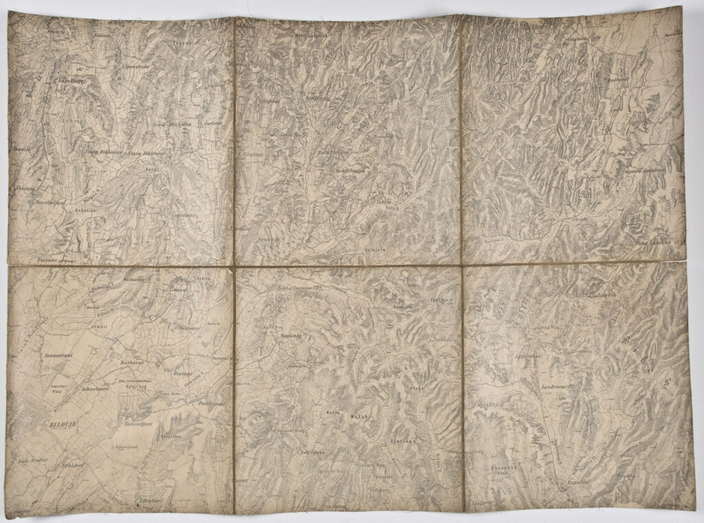
Sheets of a detailed topographic map depicting the border area of the Bjelovar-Križevci and Virovitica Counties, with toponyms of larger settlements such as Sveti Ivan Žabno in the west, and Rovišće, Bjelovar, Veliko Trojstvo, Šandrovac, Kloštar Podravski, Pitomača, Gornja Kovačica, Spišić Bukovica, Topolovica, and Rača, Velika Pisanica, and Severin in the east. Two topographic map sheets were inherited from the War Archive and Museum of the ISC (HPM/PMH-19738 – HPM/PMH-19739), while several sheets were found in the Museum (HPM/PMH-12523 – HPM/PMH-12525).

Sheets of a detailed topographic map depicting the border area of the Bjelovar-Križevci and Virovitica Counties, with toponyms of larger settlements such as Sveti Ivan Žabno in the west, and Rovišće, Bjelovar, Veliko Trojstvo, Šandrovac, Kloštar Podravski, Pitomača, Gornja Kovačica, Spišić Bukovica, Topolovica, and Rača, Velika Pisanica, and Severin in the east. Two topographic map sheets were inherited from the War Archive and Museum of the ISC (HPM/PMH-19738 – HPM/PMH-19739), while several sheets were found in the Museum (HPM/PMH-12523 – HPM/PMH-12525).
Sheets of a detailed topographic map depicting the border area of the Bjelovar-Križevci and Virovitica Counties, with toponyms of larger settlements such as Sveti Ivan Žabno in the west, and Rovišće, Bjelovar, Veliko Trojstvo, Šandrovac, Kloštar Podravski, Pitomača, Gornja Kovačica, Spišić Bukovica, Topolovica, and Rača, Velika Pisanica, and Severin in the east. Two topographic map sheets were inherited from the War Archive and Museum of the ISC (HPM/PMH-19738 – HPM/PMH-19739), while several sheets were found in the Museum (HPM/PMH-12523 – HPM/PMH-12525).
Sheets of a detailed topographic map depicting the border area of the Bjelovar-Križevci and Virovitica Counties, with toponyms of larger settlements such as Sveti Ivan Žabno in the west, and Rovišće, Bjelovar, Veliko Trojstvo, Šandrovac, Kloštar Podravski, Pitomača, Gornja Kovačica, Spišić Bukovica, Topolovica, and Rača, Velika Pisanica, and Severin in the east. Two topographic map sheets were inherited from the War Archive and Museum of the ISC (HPM/PMH-19738 – HPM/PMH-19739), while several sheets were found in the Museum (HPM/PMH-12523 – HPM/PMH-12525).
Sheets of a detailed topographic map depicting the border area of the Bjelovar-Križevci and Virovitica Counties, with toponyms of larger settlements such as Sveti Ivan Žabno in the west, and Rovišće, Bjelovar, Veliko Trojstvo, Šandrovac, Kloštar Podravski, Pitomača, Gornja Kovačica, Spišić Bukovica, Topolovica, and Rača, Velika Pisanica, and Severin in the east. Two topographic map sheets were inherited from the War Archive and Museum of the ISC (HPM/PMH-19738 – HPM/PMH-19739), while several sheets were found in the Museum (HPM/PMH-12523 – HPM/PMH-12525).
Sheets of a detailed topographic map depicting the border area of the Bjelovar-Križevci and Virovitica Counties, with toponyms of larger settlements such as Sveti Ivan Žabno in the west, and Rovišće, Bjelovar, Veliko Trojstvo, Šandrovac, Kloštar Podravski, Pitomača, Gornja Kovačica, Spišić Bukovica, Topolovica, and Rača, Velika Pisanica, and Severin in the east. Two topographic map sheets were inherited from the War Archive and Museum of the ISC (HPM/PMH-19738 – HPM/PMH-19739), while several sheets were found in the Museum (HPM/PMH-12523 – HPM/PMH-12525).
Sheets of a detailed topographic map depicting the border area of the Bjelovar-Križevci and Virovitica Counties, with toponyms of larger settlements such as Sveti Ivan Žabno in the west, and Rovišće, Bjelovar, Veliko Trojstvo, Šandrovac, Kloštar Podravski, Pitomača, Gornja Kovačica, Spišić Bukovica, Topolovica, and Rača, Velika Pisanica, and Severin in the east. Two topographic map sheets were inherited from the War Archive and Museum of the ISC (HPM/PMH-19738 – HPM/PMH-19739), while several sheets were found in the Museum (HPM/PMH-12523 – HPM/PMH-12525).
Sheets of a detailed topographic map depicting the border area of the Bjelovar-Križevci and Virovitica Counties, with toponyms of larger settlements such as Sveti Ivan Žabno in the west, and Rovišće, Bjelovar, Veliko Trojstvo, Šandrovac, Kloštar Podravski, Pitomača, Gornja Kovačica, Spišić Bukovica, Topolovica, and Rača, Velika Pisanica, and Severin in the east. Two topographic map sheets were inherited from the War Archive and Museum of the ISC (HPM/PMH-19738 – HPM/PMH-19739), while several sheets were found in the Museum (HPM/PMH-12523 – HPM/PMH-12525).
Sheets of a detailed topographic map depicting the border area of the Bjelovar-Križevci and Virovitica Counties, with toponyms of larger settlements such as Sveti Ivan Žabno in the west, and Rovišće, Bjelovar, Veliko Trojstvo, Šandrovac, Kloštar Podravski, Pitomača, Gornja Kovačica, Spišić Bukovica, Topolovica, and Rača, Velika Pisanica, and Severin in the east. Two topographic map sheets were inherited from the War Archive and Museum of the ISC (HPM/PMH-19738 – HPM/PMH-19739), while several sheets were found in the Museum (HPM/PMH-12523 – HPM/PMH-12525).