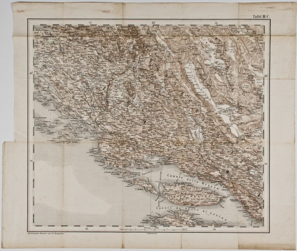
Paper, full colour print; from 47.7 x 54 cm to 55 x 74.6 cm; ; scale: 1:300,000; u. r.: labels: ‘Tafel III C.’, ‘Tafel III F.’, ‘Tafel III D.’; u. l.: ‘K.11. [: Bosna Serai (Mostar):]’; l. l.: map key, list of abbreviations with translations and note: ‘Die Occupation Bosniens und der Hercegovina’; stamp with provenance on reverse of map: ‘ARHEOL.-HISTOR. / NAR. MUZEJ / ZAGREB’
Inherited from the Archaeology and History Department of the National Museum in Zagreb
HPM/PMH-9639, HPM-101407 – HPM-101408
One copy of the general map of Bosnia and Herzegovina (HPM/PMH-9639) was inherited from the former from the Archaeology and History Department of the National Museum in Zagreb, while two copies of the map were found in the holdings of the Croatian History Museum (HPM-101407–101408). The sheets of the general map of Bosnia and Herzegovina depict the area south of Zadar to the peninsula Sveti Stefan including the nearby islands and hinterland, Mount Dinara, and parts of western, southern, and eastern Bosnia and Herzegovina. The map also depicts the southern border of the Kingdom of Dalmatia with the Ottoman Empire (Bosnia and Herzegovina) near Sutorina. The toponyms are inscribed on the map in several languages, mostly in Italian, Hungarian, Romanian, ‘South Slavic’, and Turkish, less often in German.

One copy of the general map of Bosnia and Herzegovina (HPM/PMH-9639) was inherited from the former from the Archaeology and History Department of the National Museum in Zagreb, while two copies of the map were found in the holdings of the Croatian History Museum (HPM-101407–101408). The sheets of the general map of Bosnia and Herzegovina depict the area south of Zadar to the peninsula Sveti Stefan including the nearby islands and hinterland, Mount Dinara, and parts of western, southern, and eastern Bosnia and Herzegovina. The map also depicts the southern border of the Kingdom of Dalmatia with the Ottoman Empire (Bosnia and Herzegovina) near Sutorina. The toponyms are inscribed on the map in several languages, mostly in Italian, Hungarian, Romanian, ‘South Slavic’, and Turkish, less often in German.
One copy of the general map of Bosnia and Herzegovina (HPM/PMH-9639) was inherited from the former from the Archaeology and History Department of the National Museum in Zagreb, while two copies of the map were found in the holdings of the Croatian History Museum (HPM-101407–101408). The sheets of the general map of Bosnia and Herzegovina depict the area south of Zadar to the peninsula Sveti Stefan including the nearby islands and hinterland, Mount Dinara, and parts of western, southern, and eastern Bosnia and Herzegovina. The map also depicts the southern border of the Kingdom of Dalmatia with the Ottoman Empire (Bosnia and Herzegovina) near Sutorina. The toponyms are inscribed on the map in several languages, mostly in Italian, Hungarian, Romanian, ‘South Slavic’, and Turkish, less often in German.
One copy of the general map of Bosnia and Herzegovina (HPM/PMH-9639) was inherited from the former from the Archaeology and History Department of the National Museum in Zagreb, while two copies of the map were found in the holdings of the Croatian History Museum (HPM-101407–101408). The sheets of the general map of Bosnia and Herzegovina depict the area south of Zadar to the peninsula Sveti Stefan including the nearby islands and hinterland, Mount Dinara, and parts of western, southern, and eastern Bosnia and Herzegovina. The map also depicts the southern border of the Kingdom of Dalmatia with the Ottoman Empire (Bosnia and Herzegovina) near Sutorina. The toponyms are inscribed on the map in several languages, mostly in Italian, Hungarian, Romanian, ‘South Slavic’, and Turkish, less often in German.
One copy of the general map of Bosnia and Herzegovina (HPM/PMH-9639) was inherited from the former from the Archaeology and History Department of the National Museum in Zagreb, while two copies of the map were found in the holdings of the Croatian History Museum (HPM-101407–101408). The sheets of the general map of Bosnia and Herzegovina depict the area south of Zadar to the peninsula Sveti Stefan including the nearby islands and hinterland, Mount Dinara, and parts of western, southern, and eastern Bosnia and Herzegovina. The map also depicts the southern border of the Kingdom of Dalmatia with the Ottoman Empire (Bosnia and Herzegovina) near Sutorina. The toponyms are inscribed on the map in several languages, mostly in Italian, Hungarian, Romanian, ‘South Slavic’, and Turkish, less often in German.
One copy of the general map of Bosnia and Herzegovina (HPM/PMH-9639) was inherited from the former from the Archaeology and History Department of the National Museum in Zagreb, while two copies of the map were found in the holdings of the Croatian History Museum (HPM-101407–101408). The sheets of the general map of Bosnia and Herzegovina depict the area south of Zadar to the peninsula Sveti Stefan including the nearby islands and hinterland, Mount Dinara, and parts of western, southern, and eastern Bosnia and Herzegovina. The map also depicts the southern border of the Kingdom of Dalmatia with the Ottoman Empire (Bosnia and Herzegovina) near Sutorina. The toponyms are inscribed on the map in several languages, mostly in Italian, Hungarian, Romanian, ‘South Slavic’, and Turkish, less often in German.
One copy of the general map of Bosnia and Herzegovina (HPM/PMH-9639) was inherited from the former from the Archaeology and History Department of the National Museum in Zagreb, while two copies of the map were found in the holdings of the Croatian History Museum (HPM-101407–101408). The sheets of the general map of Bosnia and Herzegovina depict the area south of Zadar to the peninsula Sveti Stefan including the nearby islands and hinterland, Mount Dinara, and parts of western, southern, and eastern Bosnia and Herzegovina. The map also depicts the southern border of the Kingdom of Dalmatia with the Ottoman Empire (Bosnia and Herzegovina) near Sutorina. The toponyms are inscribed on the map in several languages, mostly in Italian, Hungarian, Romanian, ‘South Slavic’, and Turkish, less often in German.