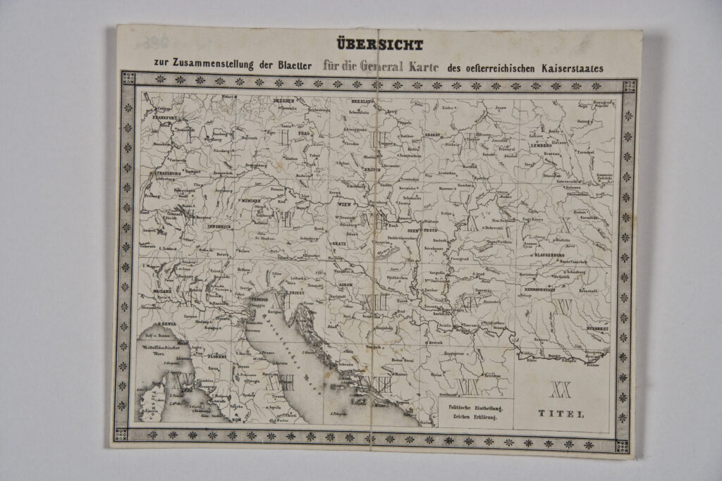
Container: cardboard, glued, map: paper on canvas, print; 49,7 × 56,5 cm; scale: 1:576,000; on volume cover: ‘GENERAL-KARTE / von / Oesterreichischen / Monarchie / von / J. SCHEDA’; map title on cover sheet: ‘GENERAL-KARTE / DES / OESTERREICHISCHEN KAISERSTAATES / MIT EINEM GROSSEN THEILE DER ANGRENZENDEN LÄNDER’; text with dedication to Emperor Franz Joseph I below title: ‘SEINER KAISERL. KÖNIGL. APOSTOLISCHEN MAJESTÄT / FRANZ JOSEF DEM ERSTEN / KAISER VON OESTERREICH, &. &. &. / IN ALLERTIEFSTER EHRFURCHT GEWIDMET. / IM K. K. MILITÄRISCH – GEOGRAFISCHEN INSTITUTE’; map author information below dedication: ‘durch Hauptmann Josef Scheda des k.k.Ingenieur-Geografen-Corps. Abtheilungs-Chef im obigen Institute, Ritter mehrerer hohen Orden, Besitzer der grossen goldenen Medaille / für Kunst und Wissenschaft von Osesterreich, Preussen, Hannover und Sachen, Mitglied des geografischen Vereins zu Berlin und Darmstadt, bearbeitet und herausgegeben. / 1856.’; map volume contains two overview sheets entitled ‘ÜBERSICHT / zur Zusammenstellung der Blaetter für die General Karte des oeſterreichischen Kaiserstaates’.
Received from the 16th Imperial and Royal Varaždin Infantry Regiment
HPM/PMH-9985 – HPM/PMH-10003/a
General map volume with a depiction of the lands of the Austrian Empire containing 19 map sheets marked with Roman numerals I to XX. The map is dedicated to Emperor Franz Joseph I, and was made on the basis of the Franciscan topographic survey (1806–1869) conducted by the staff of the Imperial and Royal Military Geographical Institute in Vienna, under the leadership of cartographer Joseph von Scheda. Along with the lands of the Empire, the map depicts the Croatian lands, on sheets XII, XIII, XIV, XVII, and XVIII. Further, it shows the area of Turkish Croatia under the name Kroatien, including the area from the river Una in the northwest to Kupres in the southeast. In the graphical sense, this map of the Austrian Empire is considered a masterwork of the then Austrian cartography. Relief forms are depicted with black hachures, using darker tones for the tallest mountaintops and lighter tones for lower mountain ranges, and also visible is the data on altitudes in the Dinaric Alps area. Scheda’s artistic capabilities are prominently expressed in the depiction of geomorphological forms. Although the map was produced in high quality from a technical standpoint, one complaint against it was that the overabundance of content and dark method of depicting relief reduced its readability. Its strengths and weaknesses aside, one can say that Scheda’s map of the Austrian Empire was the first general map with a multitude of hypsometric data, and it also served as the basis for producing general and topical cartographical depictions of the Croatian lands in various scales.
The sheets of the general map of the Austrian Empire are as follows:
I. Frankfurt
II. Prag (today Prague)
III. Brünn (today Brno)
IV. Krakau (today Kraków)
V. Lemberg (today Lviv)
VI. Innsbruck
VII. München (today Munich)
VIII. Wien (today Vienna)
IX. Debreczin (today Debrecen)
X. Klausenberg (today Cluj-Napoca)
XI. Mailand (today Milano)
XII. missing; northern Italy, Istria, the Croatian Littoral with the islands Krk, Cres, and Lošinj, plus the island of Pag
The title sheet of map XIII covers the Apennine Peninsula, the southeastern part of the Austrian Empire, Bosnia and Herzegovina, Serbia, Montenegro, and a part of the Ottoman Empire
XIV. Srijemski Karlovci area
XV. Bukarest (today Bucharest)
XVI. Florenz (today Florence)
XVII. Ancona
XVIII. Spalato (today Split)
XIX. Kruševac area with data on the administrative-territorial division of the lands of the Austrian Empire, map key, and various scales (Austrian, German, Prussian, and Russian miles, French leagues, and the Ottoman unit of length ‘Türkische Berri’)
XX. Title sheet with the author’s dedication to Emperor Franz Joseph I. In the sheet’s centre is a graphic depiction of a woman in a science and art salon, surrounded by globes, maps, documents, and surveying instruments as well as a bust of Emperor Franz Joseph I.