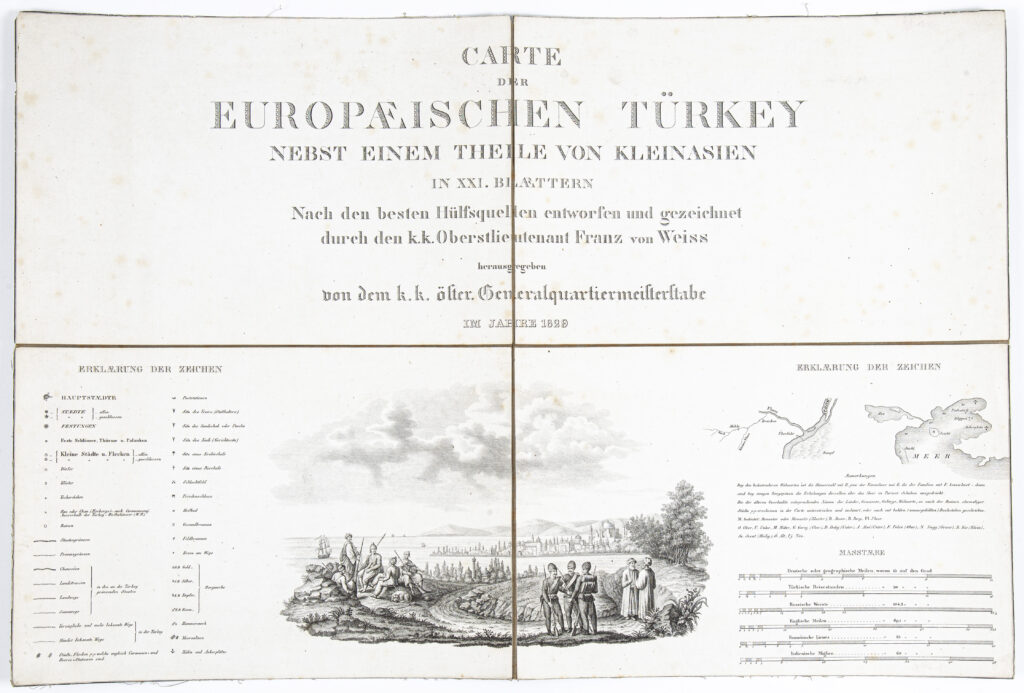
Paper on canvas, lithography; 42 x 62.6 cm; scale: various map scales are stated (German, Turkish, Russian, Italian, French, and English); title on sheet no. I: ‘CARTE / DER / EUROPAEISCHEN TÜRKEY / NEBST EINEM THEILE VON KLEINASIEN / IN XXI. BLAETTERN’, information about maker, publisher, and year of publishing with map key and symbol descriptions below title; on sheet no. II: overview map sheet: ‘SQUELETTE DER CARTE’ and table of settlement names with geographical coordinates: ‘Tafel / der geographischen Punete, nach welchen die Karte construit wurde.’; on sheet no. XX: table with statistical data: ‘STATISTISCHE UIBERSICHT / DER / EUROPAEISCHEN TÜRKEY’
Received from the 16th Imperial and Royal Varaždin Infantry Regiment
HPM/PMH-3936
Administrative map with a depiction of the European part of the Ottoman Empire and parts of Asia Minor, supplemented by a graphic depiction of Ottoman soldiers and a veduta of a part of Istanbul in the background. The map, which consists of 20 sheets, depicts numerous toponyms and small city and town plans, such as a plan of Belgrade (‘PLAN von BELGRAD’), Butrint (‘PLAN von BUTRINTO’), Preveza (‘PLAN der Halb-Jusel von PREVESA / UND DER Einfahrt in den / BUSEN von ARTA’), Corinth (‘PLAN / des Isthmus von / CORINTH’), and Rhodes (‘PLAN DER STADT UND DER HAEFEN / VON RHODUS’), as well as plans of channels and straits such as Bosporus and the Dardanelles (‘PLAN / des Canals / DER DARDANELLEN / VON LEPANTO’; ‘PLAN / des / HELLESPONTS / oder der / DARDANELLEN STRASSE’; ‘PLAN / des / BOSPHORUS / und der Umgegend von / CONSTANTINOPEL nebst der dortigen’) and the Gulf of Navarino with its port (‘PLAN / DES HAFENS / von / NAVARIN’). Sheet no. VII depicts the area of Dalmatia with its islands and hinterland, from Sinj to Dubrovnik, and south of Budva.

Administrative map with a depiction of the European part of the Ottoman Empire and parts of Asia Minor, supplemented by a graphic depiction of Ottoman soldiers and a veduta of a part of Istanbul in the background. The map, which consists of 20 sheets, depicts numerous toponyms and small city and town plans, such as a plan of Belgrade (‘PLAN von BELGRAD’), Butrint (‘PLAN von BUTRINTO’), Preveza (‘PLAN der Halb-Jusel von PREVESA / UND DER Einfahrt in den / BUSEN von ARTA’), Corinth (‘PLAN / des Isthmus von / CORINTH’), and Rhodes (‘PLAN DER STADT UND DER HAEFEN / VON RHODUS’), as well as plans of channels and straits such as Bosporus and the Dardanelles (‘PLAN / des Canals / DER DARDANELLEN / VON LEPANTO’; ‘PLAN / des / HELLESPONTS / oder der / DARDANELLEN STRASSE’; ‘PLAN / des / BOSPHORUS / und der Umgegend von / CONSTANTINOPEL nebst der dortigen’) and the Gulf of Navarino with its port (‘PLAN / DES HAFENS / von / NAVARIN’). Sheet no. VII depicts the area of Dalmatia with its islands and hinterland, from Sinj to Dubrovnik, and south of Budva.
Administrative map with a depiction of the European part of the Ottoman Empire and parts of Asia Minor, supplemented by a graphic depiction of Ottoman soldiers and a veduta of a part of Istanbul in the background. The map, which consists of 20 sheets, depicts numerous toponyms and small city and town plans, such as a plan of Belgrade (‘PLAN von BELGRAD’), Butrint (‘PLAN von BUTRINTO’), Preveza (‘PLAN der Halb-Jusel von PREVESA / UND DER Einfahrt in den / BUSEN von ARTA’), Corinth (‘PLAN / des Isthmus von / CORINTH’), and Rhodes (‘PLAN DER STADT UND DER HAEFEN / VON RHODUS’), as well as plans of channels and straits such as Bosporus and the Dardanelles (‘PLAN / des Canals / DER DARDANELLEN / VON LEPANTO’; ‘PLAN / des / HELLESPONTS / oder der / DARDANELLEN STRASSE’; ‘PLAN / des / BOSPHORUS / und der Umgegend von / CONSTANTINOPEL nebst der dortigen’) and the Gulf of Navarino with its port (‘PLAN / DES HAFENS / von / NAVARIN’). Sheet no. VII depicts the area of Dalmatia with its islands and hinterland, from Sinj to Dubrovnik, and south of Budva.
Administrative map with a depiction of the European part of the Ottoman Empire and parts of Asia Minor, supplemented by a graphic depiction of Ottoman soldiers and a veduta of a part of Istanbul in the background. The map, which consists of 20 sheets, depicts numerous toponyms and small city and town plans, such as a plan of Belgrade (‘PLAN von BELGRAD’), Butrint (‘PLAN von BUTRINTO’), Preveza (‘PLAN der Halb-Jusel von PREVESA / UND DER Einfahrt in den / BUSEN von ARTA’), Corinth (‘PLAN / des Isthmus von / CORINTH’), and Rhodes (‘PLAN DER STADT UND DER HAEFEN / VON RHODUS’), as well as plans of channels and straits such as Bosporus and the Dardanelles (‘PLAN / des Canals / DER DARDANELLEN / VON LEPANTO’; ‘PLAN / des / HELLESPONTS / oder der / DARDANELLEN STRASSE’; ‘PLAN / des / BOSPHORUS / und der Umgegend von / CONSTANTINOPEL nebst der dortigen’) and the Gulf of Navarino with its port (‘PLAN / DES HAFENS / von / NAVARIN’). Sheet no. VII depicts the area of Dalmatia with its islands and hinterland, from Sinj to Dubrovnik, and south of Budva.
Administrative map with a depiction of the European part of the Ottoman Empire and parts of Asia Minor, supplemented by a graphic depiction of Ottoman soldiers and a veduta of a part of Istanbul in the background. The map, which consists of 20 sheets, depicts numerous toponyms and small city and town plans, such as a plan of Belgrade (‘PLAN von BELGRAD’), Butrint (‘PLAN von BUTRINTO’), Preveza (‘PLAN der Halb-Jusel von PREVESA / UND DER Einfahrt in den / BUSEN von ARTA’), Corinth (‘PLAN / des Isthmus von / CORINTH’), and Rhodes (‘PLAN DER STADT UND DER HAEFEN / VON RHODUS’), as well as plans of channels and straits such as Bosporus and the Dardanelles (‘PLAN / des Canals / DER DARDANELLEN / VON LEPANTO’; ‘PLAN / des / HELLESPONTS / oder der / DARDANELLEN STRASSE’; ‘PLAN / des / BOSPHORUS / und der Umgegend von / CONSTANTINOPEL nebst der dortigen’) and the Gulf of Navarino with its port (‘PLAN / DES HAFENS / von / NAVARIN’). Sheet no. VII depicts the area of Dalmatia with its islands and hinterland, from Sinj to Dubrovnik, and south of Budva.
Administrative map with a depiction of the European part of the Ottoman Empire and parts of Asia Minor, supplemented by a graphic depiction of Ottoman soldiers and a veduta of a part of Istanbul in the background. The map, which consists of 20 sheets, depicts numerous toponyms and small city and town plans, such as a plan of Belgrade (‘PLAN von BELGRAD’), Butrint (‘PLAN von BUTRINTO’), Preveza (‘PLAN der Halb-Jusel von PREVESA / UND DER Einfahrt in den / BUSEN von ARTA’), Corinth (‘PLAN / des Isthmus von / CORINTH’), and Rhodes (‘PLAN DER STADT UND DER HAEFEN / VON RHODUS’), as well as plans of channels and straits such as Bosporus and the Dardanelles (‘PLAN / des Canals / DER DARDANELLEN / VON LEPANTO’; ‘PLAN / des / HELLESPONTS / oder der / DARDANELLEN STRASSE’; ‘PLAN / des / BOSPHORUS / und der Umgegend von / CONSTANTINOPEL nebst der dortigen’) and the Gulf of Navarino with its port (‘PLAN / DES HAFENS / von / NAVARIN’). Sheet no. VII depicts the area of Dalmatia with its islands and hinterland, from Sinj to Dubrovnik, and south of Budva.
Administrative map with a depiction of the European part of the Ottoman Empire and parts of Asia Minor, supplemented by a graphic depiction of Ottoman soldiers and a veduta of a part of Istanbul in the background. The map, which consists of 20 sheets, depicts numerous toponyms and small city and town plans, such as a plan of Belgrade (‘PLAN von BELGRAD’), Butrint (‘PLAN von BUTRINTO’), Preveza (‘PLAN der Halb-Jusel von PREVESA / UND DER Einfahrt in den / BUSEN von ARTA’), Corinth (‘PLAN / des Isthmus von / CORINTH’), and Rhodes (‘PLAN DER STADT UND DER HAEFEN / VON RHODUS’), as well as plans of channels and straits such as Bosporus and the Dardanelles (‘PLAN / des Canals / DER DARDANELLEN / VON LEPANTO’; ‘PLAN / des / HELLESPONTS / oder der / DARDANELLEN STRASSE’; ‘PLAN / des / BOSPHORUS / und der Umgegend von / CONSTANTINOPEL nebst der dortigen’) and the Gulf of Navarino with its port (‘PLAN / DES HAFENS / von / NAVARIN’). Sheet no. VII depicts the area of Dalmatia with its islands and hinterland, from Sinj to Dubrovnik, and south of Budva.
Administrative map with a depiction of the European part of the Ottoman Empire and parts of Asia Minor, supplemented by a graphic depiction of Ottoman soldiers and a veduta of a part of Istanbul in the background. The map, which consists of 20 sheets, depicts numerous toponyms and small city and town plans, such as a plan of Belgrade (‘PLAN von BELGRAD’), Butrint (‘PLAN von BUTRINTO’), Preveza (‘PLAN der Halb-Jusel von PREVESA / UND DER Einfahrt in den / BUSEN von ARTA’), Corinth (‘PLAN / des Isthmus von / CORINTH’), and Rhodes (‘PLAN DER STADT UND DER HAEFEN / VON RHODUS’), as well as plans of channels and straits such as Bosporus and the Dardanelles (‘PLAN / des Canals / DER DARDANELLEN / VON LEPANTO’; ‘PLAN / des / HELLESPONTS / oder der / DARDANELLEN STRASSE’; ‘PLAN / des / BOSPHORUS / und der Umgegend von / CONSTANTINOPEL nebst der dortigen’) and the Gulf of Navarino with its port (‘PLAN / DES HAFENS / von / NAVARIN’). Sheet no. VII depicts the area of Dalmatia with its islands and hinterland, from Sinj to Dubrovnik, and south of Budva.
Administrative map with a depiction of the European part of the Ottoman Empire and parts of Asia Minor, supplemented by a graphic depiction of Ottoman soldiers and a veduta of a part of Istanbul in the background. The map, which consists of 20 sheets, depicts numerous toponyms and small city and town plans, such as a plan of Belgrade (‘PLAN von BELGRAD’), Butrint (‘PLAN von BUTRINTO’), Preveza (‘PLAN der Halb-Jusel von PREVESA / UND DER Einfahrt in den / BUSEN von ARTA’), Corinth (‘PLAN / des Isthmus von / CORINTH’), and Rhodes (‘PLAN DER STADT UND DER HAEFEN / VON RHODUS’), as well as plans of channels and straits such as Bosporus and the Dardanelles (‘PLAN / des Canals / DER DARDANELLEN / VON LEPANTO’; ‘PLAN / des / HELLESPONTS / oder der / DARDANELLEN STRASSE’; ‘PLAN / des / BOSPHORUS / und der Umgegend von / CONSTANTINOPEL nebst der dortigen’) and the Gulf of Navarino with its port (‘PLAN / DES HAFENS / von / NAVARIN’). Sheet no. VII depicts the area of Dalmatia with its islands and hinterland, from Sinj to Dubrovnik, and south of Budva.
Administrative map with a depiction of the European part of the Ottoman Empire and parts of Asia Minor, supplemented by a graphic depiction of Ottoman soldiers and a veduta of a part of Istanbul in the background. The map, which consists of 20 sheets, depicts numerous toponyms and small city and town plans, such as a plan of Belgrade (‘PLAN von BELGRAD’), Butrint (‘PLAN von BUTRINTO’), Preveza (‘PLAN der Halb-Jusel von PREVESA / UND DER Einfahrt in den / BUSEN von ARTA’), Corinth (‘PLAN / des Isthmus von / CORINTH’), and Rhodes (‘PLAN DER STADT UND DER HAEFEN / VON RHODUS’), as well as plans of channels and straits such as Bosporus and the Dardanelles (‘PLAN / des Canals / DER DARDANELLEN / VON LEPANTO’; ‘PLAN / des / HELLESPONTS / oder der / DARDANELLEN STRASSE’; ‘PLAN / des / BOSPHORUS / und der Umgegend von / CONSTANTINOPEL nebst der dortigen’) and the Gulf of Navarino with its port (‘PLAN / DES HAFENS / von / NAVARIN’). Sheet no. VII depicts the area of Dalmatia with its islands and hinterland, from Sinj to Dubrovnik, and south of Budva.
Administrative map with a depiction of the European part of the Ottoman Empire and parts of Asia Minor, supplemented by a graphic depiction of Ottoman soldiers and a veduta of a part of Istanbul in the background. The map, which consists of 20 sheets, depicts numerous toponyms and small city and town plans, such as a plan of Belgrade (‘PLAN von BELGRAD’), Butrint (‘PLAN von BUTRINTO’), Preveza (‘PLAN der Halb-Jusel von PREVESA / UND DER Einfahrt in den / BUSEN von ARTA’), Corinth (‘PLAN / des Isthmus von / CORINTH’), and Rhodes (‘PLAN DER STADT UND DER HAEFEN / VON RHODUS’), as well as plans of channels and straits such as Bosporus and the Dardanelles (‘PLAN / des Canals / DER DARDANELLEN / VON LEPANTO’; ‘PLAN / des / HELLESPONTS / oder der / DARDANELLEN STRASSE’; ‘PLAN / des / BOSPHORUS / und der Umgegend von / CONSTANTINOPEL nebst der dortigen’) and the Gulf of Navarino with its port (‘PLAN / DES HAFENS / von / NAVARIN’). Sheet no. VII depicts the area of Dalmatia with its islands and hinterland, from Sinj to Dubrovnik, and south of Budva.
Administrative map with a depiction of the European part of the Ottoman Empire and parts of Asia Minor, supplemented by a graphic depiction of Ottoman soldiers and a veduta of a part of Istanbul in the background. The map, which consists of 20 sheets, depicts numerous toponyms and small city and town plans, such as a plan of Belgrade (‘PLAN von BELGRAD’), Butrint (‘PLAN von BUTRINTO’), Preveza (‘PLAN der Halb-Jusel von PREVESA / UND DER Einfahrt in den / BUSEN von ARTA’), Corinth (‘PLAN / des Isthmus von / CORINTH’), and Rhodes (‘PLAN DER STADT UND DER HAEFEN / VON RHODUS’), as well as plans of channels and straits such as Bosporus and the Dardanelles (‘PLAN / des Canals / DER DARDANELLEN / VON LEPANTO’; ‘PLAN / des / HELLESPONTS / oder der / DARDANELLEN STRASSE’; ‘PLAN / des / BOSPHORUS / und der Umgegend von / CONSTANTINOPEL nebst der dortigen’) and the Gulf of Navarino with its port (‘PLAN / DES HAFENS / von / NAVARIN’). Sheet no. VII depicts the area of Dalmatia with its islands and hinterland, from Sinj to Dubrovnik, and south of Budva.
Administrative map with a depiction of the European part of the Ottoman Empire and parts of Asia Minor, supplemented by a graphic depiction of Ottoman soldiers and a veduta of a part of Istanbul in the background. The map, which consists of 20 sheets, depicts numerous toponyms and small city and town plans, such as a plan of Belgrade (‘PLAN von BELGRAD’), Butrint (‘PLAN von BUTRINTO’), Preveza (‘PLAN der Halb-Jusel von PREVESA / UND DER Einfahrt in den / BUSEN von ARTA’), Corinth (‘PLAN / des Isthmus von / CORINTH’), and Rhodes (‘PLAN DER STADT UND DER HAEFEN / VON RHODUS’), as well as plans of channels and straits such as Bosporus and the Dardanelles (‘PLAN / des Canals / DER DARDANELLEN / VON LEPANTO’; ‘PLAN / des / HELLESPONTS / oder der / DARDANELLEN STRASSE’; ‘PLAN / des / BOSPHORUS / und der Umgegend von / CONSTANTINOPEL nebst der dortigen’) and the Gulf of Navarino with its port (‘PLAN / DES HAFENS / von / NAVARIN’). Sheet no. VII depicts the area of Dalmatia with its islands and hinterland, from Sinj to Dubrovnik, and south of Budva.
Administrative map with a depiction of the European part of the Ottoman Empire and parts of Asia Minor, supplemented by a graphic depiction of Ottoman soldiers and a veduta of a part of Istanbul in the background. The map, which consists of 20 sheets, depicts numerous toponyms and small city and town plans, such as a plan of Belgrade (‘PLAN von BELGRAD’), Butrint (‘PLAN von BUTRINTO’), Preveza (‘PLAN der Halb-Jusel von PREVESA / UND DER Einfahrt in den / BUSEN von ARTA’), Corinth (‘PLAN / des Isthmus von / CORINTH’), and Rhodes (‘PLAN DER STADT UND DER HAEFEN / VON RHODUS’), as well as plans of channels and straits such as Bosporus and the Dardanelles (‘PLAN / des Canals / DER DARDANELLEN / VON LEPANTO’; ‘PLAN / des / HELLESPONTS / oder der / DARDANELLEN STRASSE’; ‘PLAN / des / BOSPHORUS / und der Umgegend von / CONSTANTINOPEL nebst der dortigen’) and the Gulf of Navarino with its port (‘PLAN / DES HAFENS / von / NAVARIN’). Sheet no. VII depicts the area of Dalmatia with its islands and hinterland, from Sinj to Dubrovnik, and south of Budva.
Administrative map with a depiction of the European part of the Ottoman Empire and parts of Asia Minor, supplemented by a graphic depiction of Ottoman soldiers and a veduta of a part of Istanbul in the background. The map, which consists of 20 sheets, depicts numerous toponyms and small city and town plans, such as a plan of Belgrade (‘PLAN von BELGRAD’), Butrint (‘PLAN von BUTRINTO’), Preveza (‘PLAN der Halb-Jusel von PREVESA / UND DER Einfahrt in den / BUSEN von ARTA’), Corinth (‘PLAN / des Isthmus von / CORINTH’), and Rhodes (‘PLAN DER STADT UND DER HAEFEN / VON RHODUS’), as well as plans of channels and straits such as Bosporus and the Dardanelles (‘PLAN / des Canals / DER DARDANELLEN / VON LEPANTO’; ‘PLAN / des / HELLESPONTS / oder der / DARDANELLEN STRASSE’; ‘PLAN / des / BOSPHORUS / und der Umgegend von / CONSTANTINOPEL nebst der dortigen’) and the Gulf of Navarino with its port (‘PLAN / DES HAFENS / von / NAVARIN’). Sheet no. VII depicts the area of Dalmatia with its islands and hinterland, from Sinj to Dubrovnik, and south of Budva.
Administrative map with a depiction of the European part of the Ottoman Empire and parts of Asia Minor, supplemented by a graphic depiction of Ottoman soldiers and a veduta of a part of Istanbul in the background. The map, which consists of 20 sheets, depicts numerous toponyms and small city and town plans, such as a plan of Belgrade (‘PLAN von BELGRAD’), Butrint (‘PLAN von BUTRINTO’), Preveza (‘PLAN der Halb-Jusel von PREVESA / UND DER Einfahrt in den / BUSEN von ARTA’), Corinth (‘PLAN / des Isthmus von / CORINTH’), and Rhodes (‘PLAN DER STADT UND DER HAEFEN / VON RHODUS’), as well as plans of channels and straits such as Bosporus and the Dardanelles (‘PLAN / des Canals / DER DARDANELLEN / VON LEPANTO’; ‘PLAN / des / HELLESPONTS / oder der / DARDANELLEN STRASSE’; ‘PLAN / des / BOSPHORUS / und der Umgegend von / CONSTANTINOPEL nebst der dortigen’) and the Gulf of Navarino with its port (‘PLAN / DES HAFENS / von / NAVARIN’). Sheet no. VII depicts the area of Dalmatia with its islands and hinterland, from Sinj to Dubrovnik, and south of Budva.
Administrative map with a depiction of the European part of the Ottoman Empire and parts of Asia Minor, supplemented by a graphic depiction of Ottoman soldiers and a veduta of a part of Istanbul in the background. The map, which consists of 20 sheets, depicts numerous toponyms and small city and town plans, such as a plan of Belgrade (‘PLAN von BELGRAD’), Butrint (‘PLAN von BUTRINTO’), Preveza (‘PLAN der Halb-Jusel von PREVESA / UND DER Einfahrt in den / BUSEN von ARTA’), Corinth (‘PLAN / des Isthmus von / CORINTH’), and Rhodes (‘PLAN DER STADT UND DER HAEFEN / VON RHODUS’), as well as plans of channels and straits such as Bosporus and the Dardanelles (‘PLAN / des Canals / DER DARDANELLEN / VON LEPANTO’; ‘PLAN / des / HELLESPONTS / oder der / DARDANELLEN STRASSE’; ‘PLAN / des / BOSPHORUS / und der Umgegend von / CONSTANTINOPEL nebst der dortigen’) and the Gulf of Navarino with its port (‘PLAN / DES HAFENS / von / NAVARIN’). Sheet no. VII depicts the area of Dalmatia with its islands and hinterland, from Sinj to Dubrovnik, and south of Budva.
Administrative map with a depiction of the European part of the Ottoman Empire and parts of Asia Minor, supplemented by a graphic depiction of Ottoman soldiers and a veduta of a part of Istanbul in the background. The map, which consists of 20 sheets, depicts numerous toponyms and small city and town plans, such as a plan of Belgrade (‘PLAN von BELGRAD’), Butrint (‘PLAN von BUTRINTO’), Preveza (‘PLAN der Halb-Jusel von PREVESA / UND DER Einfahrt in den / BUSEN von ARTA’), Corinth (‘PLAN / des Isthmus von / CORINTH’), and Rhodes (‘PLAN DER STADT UND DER HAEFEN / VON RHODUS’), as well as plans of channels and straits such as Bosporus and the Dardanelles (‘PLAN / des Canals / DER DARDANELLEN / VON LEPANTO’; ‘PLAN / des / HELLESPONTS / oder der / DARDANELLEN STRASSE’; ‘PLAN / des / BOSPHORUS / und der Umgegend von / CONSTANTINOPEL nebst der dortigen’) and the Gulf of Navarino with its port (‘PLAN / DES HAFENS / von / NAVARIN’). Sheet no. VII depicts the area of Dalmatia with its islands and hinterland, from Sinj to Dubrovnik, and south of Budva.
Administrative map with a depiction of the European part of the Ottoman Empire and parts of Asia Minor, supplemented by a graphic depiction of Ottoman soldiers and a veduta of a part of Istanbul in the background. The map, which consists of 20 sheets, depicts numerous toponyms and small city and town plans, such as a plan of Belgrade (‘PLAN von BELGRAD’), Butrint (‘PLAN von BUTRINTO’), Preveza (‘PLAN der Halb-Jusel von PREVESA / UND DER Einfahrt in den / BUSEN von ARTA’), Corinth (‘PLAN / des Isthmus von / CORINTH’), and Rhodes (‘PLAN DER STADT UND DER HAEFEN / VON RHODUS’), as well as plans of channels and straits such as Bosporus and the Dardanelles (‘PLAN / des Canals / DER DARDANELLEN / VON LEPANTO’; ‘PLAN / des / HELLESPONTS / oder der / DARDANELLEN STRASSE’; ‘PLAN / des / BOSPHORUS / und der Umgegend von / CONSTANTINOPEL nebst der dortigen’) and the Gulf of Navarino with its port (‘PLAN / DES HAFENS / von / NAVARIN’). Sheet no. VII depicts the area of Dalmatia with its islands and hinterland, from Sinj to Dubrovnik, and south of Budva.
Administrative map with a depiction of the European part of the Ottoman Empire and parts of Asia Minor, supplemented by a graphic depiction of Ottoman soldiers and a veduta of a part of Istanbul in the background. The map, which consists of 20 sheets, depicts numerous toponyms and small city and town plans, such as a plan of Belgrade (‘PLAN von BELGRAD’), Butrint (‘PLAN von BUTRINTO’), Preveza (‘PLAN der Halb-Jusel von PREVESA / UND DER Einfahrt in den / BUSEN von ARTA’), Corinth (‘PLAN / des Isthmus von / CORINTH’), and Rhodes (‘PLAN DER STADT UND DER HAEFEN / VON RHODUS’), as well as plans of channels and straits such as Bosporus and the Dardanelles (‘PLAN / des Canals / DER DARDANELLEN / VON LEPANTO’; ‘PLAN / des / HELLESPONTS / oder der / DARDANELLEN STRASSE’; ‘PLAN / des / BOSPHORUS / und der Umgegend von / CONSTANTINOPEL nebst der dortigen’) and the Gulf of Navarino with its port (‘PLAN / DES HAFENS / von / NAVARIN’). Sheet no. VII depicts the area of Dalmatia with its islands and hinterland, from Sinj to Dubrovnik, and south of Budva.
Administrative map with a depiction of the European part of the Ottoman Empire and parts of Asia Minor, supplemented by a graphic depiction of Ottoman soldiers and a veduta of a part of Istanbul in the background. The map, which consists of 20 sheets, depicts numerous toponyms and small city and town plans, such as a plan of Belgrade (‘PLAN von BELGRAD’), Butrint (‘PLAN von BUTRINTO’), Preveza (‘PLAN der Halb-Jusel von PREVESA / UND DER Einfahrt in den / BUSEN von ARTA’), Corinth (‘PLAN / des Isthmus von / CORINTH’), and Rhodes (‘PLAN DER STADT UND DER HAEFEN / VON RHODUS’), as well as plans of channels and straits such as Bosporus and the Dardanelles (‘PLAN / des Canals / DER DARDANELLEN / VON LEPANTO’; ‘PLAN / des / HELLESPONTS / oder der / DARDANELLEN STRASSE’; ‘PLAN / des / BOSPHORUS / und der Umgegend von / CONSTANTINOPEL nebst der dortigen’) and the Gulf of Navarino with its port (‘PLAN / DES HAFENS / von / NAVARIN’). Sheet no. VII depicts the area of Dalmatia with its islands and hinterland, from Sinj to Dubrovnik, and south of Budva.
Administrative map with a depiction of the European part of the Ottoman Empire and parts of Asia Minor, supplemented by a graphic depiction of Ottoman soldiers and a veduta of a part of Istanbul in the background. The map, which consists of 20 sheets, depicts numerous toponyms and small city and town plans, such as a plan of Belgrade (‘PLAN von BELGRAD’), Butrint (‘PLAN von BUTRINTO’), Preveza (‘PLAN der Halb-Jusel von PREVESA / UND DER Einfahrt in den / BUSEN von ARTA’), Corinth (‘PLAN / des Isthmus von / CORINTH’), and Rhodes (‘PLAN DER STADT UND DER HAEFEN / VON RHODUS’), as well as plans of channels and straits such as Bosporus and the Dardanelles (‘PLAN / des Canals / DER DARDANELLEN / VON LEPANTO’; ‘PLAN / des / HELLESPONTS / oder der / DARDANELLEN STRASSE’; ‘PLAN / des / BOSPHORUS / und der Umgegend von / CONSTANTINOPEL nebst der dortigen’) and the Gulf of Navarino with its port (‘PLAN / DES HAFENS / von / NAVARIN’). Sheet no. VII depicts the area of Dalmatia with its islands and hinterland, from Sinj to Dubrovnik, and south of Budva.
Administrative map with a depiction of the European part of the Ottoman Empire and parts of Asia Minor, supplemented by a graphic depiction of Ottoman soldiers and a veduta of a part of Istanbul in the background. The map, which consists of 20 sheets, depicts numerous toponyms and small city and town plans, such as a plan of Belgrade (‘PLAN von BELGRAD’), Butrint (‘PLAN von BUTRINTO’), Preveza (‘PLAN der Halb-Jusel von PREVESA / UND DER Einfahrt in den / BUSEN von ARTA’), Corinth (‘PLAN / des Isthmus von / CORINTH’), and Rhodes (‘PLAN DER STADT UND DER HAEFEN / VON RHODUS’), as well as plans of channels and straits such as Bosporus and the Dardanelles (‘PLAN / des Canals / DER DARDANELLEN / VON LEPANTO’; ‘PLAN / des / HELLESPONTS / oder der / DARDANELLEN STRASSE’; ‘PLAN / des / BOSPHORUS / und der Umgegend von / CONSTANTINOPEL nebst der dortigen’) and the Gulf of Navarino with its port (‘PLAN / DES HAFENS / von / NAVARIN’). Sheet no. VII depicts the area of Dalmatia with its islands and hinterland, from Sinj to Dubrovnik, and south of Budva.
Administrative map with a depiction of the European part of the Ottoman Empire and parts of Asia Minor, supplemented by a graphic depiction of Ottoman soldiers and a veduta of a part of Istanbul in the background. The map, which consists of 20 sheets, depicts numerous toponyms and small city and town plans, such as a plan of Belgrade (‘PLAN von BELGRAD’), Butrint (‘PLAN von BUTRINTO’), Preveza (‘PLAN der Halb-Jusel von PREVESA / UND DER Einfahrt in den / BUSEN von ARTA’), Corinth (‘PLAN / des Isthmus von / CORINTH’), and Rhodes (‘PLAN DER STADT UND DER HAEFEN / VON RHODUS’), as well as plans of channels and straits such as Bosporus and the Dardanelles (‘PLAN / des Canals / DER DARDANELLEN / VON LEPANTO’; ‘PLAN / des / HELLESPONTS / oder der / DARDANELLEN STRASSE’; ‘PLAN / des / BOSPHORUS / und der Umgegend von / CONSTANTINOPEL nebst der dortigen’) and the Gulf of Navarino with its port (‘PLAN / DES HAFENS / von / NAVARIN’). Sheet no. VII depicts the area of Dalmatia with its islands and hinterland, from Sinj to Dubrovnik, and south of Budva.
Administrative map with a depiction of the European part of the Ottoman Empire and parts of Asia Minor, supplemented by a graphic depiction of Ottoman soldiers and a veduta of a part of Istanbul in the background. The map, which consists of 20 sheets, depicts numerous toponyms and small city and town plans, such as a plan of Belgrade (‘PLAN von BELGRAD’), Butrint (‘PLAN von BUTRINTO’), Preveza (‘PLAN der Halb-Jusel von PREVESA / UND DER Einfahrt in den / BUSEN von ARTA’), Corinth (‘PLAN / des Isthmus von / CORINTH’), and Rhodes (‘PLAN DER STADT UND DER HAEFEN / VON RHODUS’), as well as plans of channels and straits such as Bosporus and the Dardanelles (‘PLAN / des Canals / DER DARDANELLEN / VON LEPANTO’; ‘PLAN / des / HELLESPONTS / oder der / DARDANELLEN STRASSE’; ‘PLAN / des / BOSPHORUS / und der Umgegend von / CONSTANTINOPEL nebst der dortigen’) and the Gulf of Navarino with its port (‘PLAN / DES HAFENS / von / NAVARIN’). Sheet no. VII depicts the area of Dalmatia with its islands and hinterland, from Sinj to Dubrovnik, and south of Budva.
Administrative map with a depiction of the European part of the Ottoman Empire and parts of Asia Minor, supplemented by a graphic depiction of Ottoman soldiers and a veduta of a part of Istanbul in the background. The map, which consists of 20 sheets, depicts numerous toponyms and small city and town plans, such as a plan of Belgrade (‘PLAN von BELGRAD’), Butrint (‘PLAN von BUTRINTO’), Preveza (‘PLAN der Halb-Jusel von PREVESA / UND DER Einfahrt in den / BUSEN von ARTA’), Corinth (‘PLAN / des Isthmus von / CORINTH’), and Rhodes (‘PLAN DER STADT UND DER HAEFEN / VON RHODUS’), as well as plans of channels and straits such as Bosporus and the Dardanelles (‘PLAN / des Canals / DER DARDANELLEN / VON LEPANTO’; ‘PLAN / des / HELLESPONTS / oder der / DARDANELLEN STRASSE’; ‘PLAN / des / BOSPHORUS / und der Umgegend von / CONSTANTINOPEL nebst der dortigen’) and the Gulf of Navarino with its port (‘PLAN / DES HAFENS / von / NAVARIN’). Sheet no. VII depicts the area of Dalmatia with its islands and hinterland, from Sinj to Dubrovnik, and south of Budva.
Administrative map with a depiction of the European part of the Ottoman Empire and parts of Asia Minor, supplemented by a graphic depiction of Ottoman soldiers and a veduta of a part of Istanbul in the background. The map, which consists of 20 sheets, depicts numerous toponyms and small city and town plans, such as a plan of Belgrade (‘PLAN von BELGRAD’), Butrint (‘PLAN von BUTRINTO’), Preveza (‘PLAN der Halb-Jusel von PREVESA / UND DER Einfahrt in den / BUSEN von ARTA’), Corinth (‘PLAN / des Isthmus von / CORINTH’), and Rhodes (‘PLAN DER STADT UND DER HAEFEN / VON RHODUS’), as well as plans of channels and straits such as Bosporus and the Dardanelles (‘PLAN / des Canals / DER DARDANELLEN / VON LEPANTO’; ‘PLAN / des / HELLESPONTS / oder der / DARDANELLEN STRASSE’; ‘PLAN / des / BOSPHORUS / und der Umgegend von / CONSTANTINOPEL nebst der dortigen’) and the Gulf of Navarino with its port (‘PLAN / DES HAFENS / von / NAVARIN’). Sheet no. VII depicts the area of Dalmatia with its islands and hinterland, from Sinj to Dubrovnik, and south of Budva.
Administrative map with a depiction of the European part of the Ottoman Empire and parts of Asia Minor, supplemented by a graphic depiction of Ottoman soldiers and a veduta of a part of Istanbul in the background. The map, which consists of 20 sheets, depicts numerous toponyms and small city and town plans, such as a plan of Belgrade (‘PLAN von BELGRAD’), Butrint (‘PLAN von BUTRINTO’), Preveza (‘PLAN der Halb-Jusel von PREVESA / UND DER Einfahrt in den / BUSEN von ARTA’), Corinth (‘PLAN / des Isthmus von / CORINTH’), and Rhodes (‘PLAN DER STADT UND DER HAEFEN / VON RHODUS’), as well as plans of channels and straits such as Bosporus and the Dardanelles (‘PLAN / des Canals / DER DARDANELLEN / VON LEPANTO’; ‘PLAN / des / HELLESPONTS / oder der / DARDANELLEN STRASSE’; ‘PLAN / des / BOSPHORUS / und der Umgegend von / CONSTANTINOPEL nebst der dortigen’) and the Gulf of Navarino with its port (‘PLAN / DES HAFENS / von / NAVARIN’). Sheet no. VII depicts the area of Dalmatia with its islands and hinterland, from Sinj to Dubrovnik, and south of Budva.
Administrative map with a depiction of the European part of the Ottoman Empire and parts of Asia Minor, supplemented by a graphic depiction of Ottoman soldiers and a veduta of a part of Istanbul in the background. The map, which consists of 20 sheets, depicts numerous toponyms and small city and town plans, such as a plan of Belgrade (‘PLAN von BELGRAD’), Butrint (‘PLAN von BUTRINTO’), Preveza (‘PLAN der Halb-Jusel von PREVESA / UND DER Einfahrt in den / BUSEN von ARTA’), Corinth (‘PLAN / des Isthmus von / CORINTH’), and Rhodes (‘PLAN DER STADT UND DER HAEFEN / VON RHODUS’), as well as plans of channels and straits such as Bosporus and the Dardanelles (‘PLAN / des Canals / DER DARDANELLEN / VON LEPANTO’; ‘PLAN / des / HELLESPONTS / oder der / DARDANELLEN STRASSE’; ‘PLAN / des / BOSPHORUS / und der Umgegend von / CONSTANTINOPEL nebst der dortigen’) and the Gulf of Navarino with its port (‘PLAN / DES HAFENS / von / NAVARIN’). Sheet no. VII depicts the area of Dalmatia with its islands and hinterland, from Sinj to Dubrovnik, and south of Budva.
Administrative map with a depiction of the European part of the Ottoman Empire and parts of Asia Minor, supplemented by a graphic depiction of Ottoman soldiers and a veduta of a part of Istanbul in the background. The map, which consists of 20 sheets, depicts numerous toponyms and small city and town plans, such as a plan of Belgrade (‘PLAN von BELGRAD’), Butrint (‘PLAN von BUTRINTO’), Preveza (‘PLAN der Halb-Jusel von PREVESA / UND DER Einfahrt in den / BUSEN von ARTA’), Corinth (‘PLAN / des Isthmus von / CORINTH’), and Rhodes (‘PLAN DER STADT UND DER HAEFEN / VON RHODUS’), as well as plans of channels and straits such as Bosporus and the Dardanelles (‘PLAN / des Canals / DER DARDANELLEN / VON LEPANTO’; ‘PLAN / des / HELLESPONTS / oder der / DARDANELLEN STRASSE’; ‘PLAN / des / BOSPHORUS / und der Umgegend von / CONSTANTINOPEL nebst der dortigen’) and the Gulf of Navarino with its port (‘PLAN / DES HAFENS / von / NAVARIN’). Sheet no. VII depicts the area of Dalmatia with its islands and hinterland, from Sinj to Dubrovnik, and south of Budva.
Administrative map with a depiction of the European part of the Ottoman Empire and parts of Asia Minor, supplemented by a graphic depiction of Ottoman soldiers and a veduta of a part of Istanbul in the background. The map, which consists of 20 sheets, depicts numerous toponyms and small city and town plans, such as a plan of Belgrade (‘PLAN von BELGRAD’), Butrint (‘PLAN von BUTRINTO’), Preveza (‘PLAN der Halb-Jusel von PREVESA / UND DER Einfahrt in den / BUSEN von ARTA’), Corinth (‘PLAN / des Isthmus von / CORINTH’), and Rhodes (‘PLAN DER STADT UND DER HAEFEN / VON RHODUS’), as well as plans of channels and straits such as Bosporus and the Dardanelles (‘PLAN / des Canals / DER DARDANELLEN / VON LEPANTO’; ‘PLAN / des / HELLESPONTS / oder der / DARDANELLEN STRASSE’; ‘PLAN / des / BOSPHORUS / und der Umgegend von / CONSTANTINOPEL nebst der dortigen’) and the Gulf of Navarino with its port (‘PLAN / DES HAFENS / von / NAVARIN’). Sheet no. VII depicts the area of Dalmatia with its islands and hinterland, from Sinj to Dubrovnik, and south of Budva.
Administrative map with a depiction of the European part of the Ottoman Empire and parts of Asia Minor, supplemented by a graphic depiction of Ottoman soldiers and a veduta of a part of Istanbul in the background. The map, which consists of 20 sheets, depicts numerous toponyms and small city and town plans, such as a plan of Belgrade (‘PLAN von BELGRAD’), Butrint (‘PLAN von BUTRINTO’), Preveza (‘PLAN der Halb-Jusel von PREVESA / UND DER Einfahrt in den / BUSEN von ARTA’), Corinth (‘PLAN / des Isthmus von / CORINTH’), and Rhodes (‘PLAN DER STADT UND DER HAEFEN / VON RHODUS’), as well as plans of channels and straits such as Bosporus and the Dardanelles (‘PLAN / des Canals / DER DARDANELLEN / VON LEPANTO’; ‘PLAN / des / HELLESPONTS / oder der / DARDANELLEN STRASSE’; ‘PLAN / des / BOSPHORUS / und der Umgegend von / CONSTANTINOPEL nebst der dortigen’) and the Gulf of Navarino with its port (‘PLAN / DES HAFENS / von / NAVARIN’). Sheet no. VII depicts the area of Dalmatia with its islands and hinterland, from Sinj to Dubrovnik, and south of Budva.
Administrative map with a depiction of the European part of the Ottoman Empire and parts of Asia Minor, supplemented by a graphic depiction of Ottoman soldiers and a veduta of a part of Istanbul in the background. The map, which consists of 20 sheets, depicts numerous toponyms and small city and town plans, such as a plan of Belgrade (‘PLAN von BELGRAD’), Butrint (‘PLAN von BUTRINTO’), Preveza (‘PLAN der Halb-Jusel von PREVESA / UND DER Einfahrt in den / BUSEN von ARTA’), Corinth (‘PLAN / des Isthmus von / CORINTH’), and Rhodes (‘PLAN DER STADT UND DER HAEFEN / VON RHODUS’), as well as plans of channels and straits such as Bosporus and the Dardanelles (‘PLAN / des Canals / DER DARDANELLEN / VON LEPANTO’; ‘PLAN / des / HELLESPONTS / oder der / DARDANELLEN STRASSE’; ‘PLAN / des / BOSPHORUS / und der Umgegend von / CONSTANTINOPEL nebst der dortigen’) and the Gulf of Navarino with its port (‘PLAN / DES HAFENS / von / NAVARIN’). Sheet no. VII depicts the area of Dalmatia with its islands and hinterland, from Sinj to Dubrovnik, and south of Budva.
Administrative map with a depiction of the European part of the Ottoman Empire and parts of Asia Minor, supplemented by a graphic depiction of Ottoman soldiers and a veduta of a part of Istanbul in the background. The map, which consists of 20 sheets, depicts numerous toponyms and small city and town plans, such as a plan of Belgrade (‘PLAN von BELGRAD’), Butrint (‘PLAN von BUTRINTO’), Preveza (‘PLAN der Halb-Jusel von PREVESA / UND DER Einfahrt in den / BUSEN von ARTA’), Corinth (‘PLAN / des Isthmus von / CORINTH’), and Rhodes (‘PLAN DER STADT UND DER HAEFEN / VON RHODUS’), as well as plans of channels and straits such as Bosporus and the Dardanelles (‘PLAN / des Canals / DER DARDANELLEN / VON LEPANTO’; ‘PLAN / des / HELLESPONTS / oder der / DARDANELLEN STRASSE’; ‘PLAN / des / BOSPHORUS / und der Umgegend von / CONSTANTINOPEL nebst der dortigen’) and the Gulf of Navarino with its port (‘PLAN / DES HAFENS / von / NAVARIN’). Sheet no. VII depicts the area of Dalmatia with its islands and hinterland, from Sinj to Dubrovnik, and south of Budva.
Administrative map with a depiction of the European part of the Ottoman Empire and parts of Asia Minor, supplemented by a graphic depiction of Ottoman soldiers and a veduta of a part of Istanbul in the background. The map, which consists of 20 sheets, depicts numerous toponyms and small city and town plans, such as a plan of Belgrade (‘PLAN von BELGRAD’), Butrint (‘PLAN von BUTRINTO’), Preveza (‘PLAN der Halb-Jusel von PREVESA / UND DER Einfahrt in den / BUSEN von ARTA’), Corinth (‘PLAN / des Isthmus von / CORINTH’), and Rhodes (‘PLAN DER STADT UND DER HAEFEN / VON RHODUS’), as well as plans of channels and straits such as Bosporus and the Dardanelles (‘PLAN / des Canals / DER DARDANELLEN / VON LEPANTO’; ‘PLAN / des / HELLESPONTS / oder der / DARDANELLEN STRASSE’; ‘PLAN / des / BOSPHORUS / und der Umgegend von / CONSTANTINOPEL nebst der dortigen’) and the Gulf of Navarino with its port (‘PLAN / DES HAFENS / von / NAVARIN’). Sheet no. VII depicts the area of Dalmatia with its islands and hinterland, from Sinj to Dubrovnik, and south of Budva.
Administrative map with a depiction of the European part of the Ottoman Empire and parts of Asia Minor, supplemented by a graphic depiction of Ottoman soldiers and a veduta of a part of Istanbul in the background. The map, which consists of 20 sheets, depicts numerous toponyms and small city and town plans, such as a plan of Belgrade (‘PLAN von BELGRAD’), Butrint (‘PLAN von BUTRINTO’), Preveza (‘PLAN der Halb-Jusel von PREVESA / UND DER Einfahrt in den / BUSEN von ARTA’), Corinth (‘PLAN / des Isthmus von / CORINTH’), and Rhodes (‘PLAN DER STADT UND DER HAEFEN / VON RHODUS’), as well as plans of channels and straits such as Bosporus and the Dardanelles (‘PLAN / des Canals / DER DARDANELLEN / VON LEPANTO’; ‘PLAN / des / HELLESPONTS / oder der / DARDANELLEN STRASSE’; ‘PLAN / des / BOSPHORUS / und der Umgegend von / CONSTANTINOPEL nebst der dortigen’) and the Gulf of Navarino with its port (‘PLAN / DES HAFENS / von / NAVARIN’). Sheet no. VII depicts the area of Dalmatia with its islands and hinterland, from Sinj to Dubrovnik, and south of Budva.
Administrative map with a depiction of the European part of the Ottoman Empire and parts of Asia Minor, supplemented by a graphic depiction of Ottoman soldiers and a veduta of a part of Istanbul in the background. The map, which consists of 20 sheets, depicts numerous toponyms and small city and town plans, such as a plan of Belgrade (‘PLAN von BELGRAD’), Butrint (‘PLAN von BUTRINTO’), Preveza (‘PLAN der Halb-Jusel von PREVESA / UND DER Einfahrt in den / BUSEN von ARTA’), Corinth (‘PLAN / des Isthmus von / CORINTH’), and Rhodes (‘PLAN DER STADT UND DER HAEFEN / VON RHODUS’), as well as plans of channels and straits such as Bosporus and the Dardanelles (‘PLAN / des Canals / DER DARDANELLEN / VON LEPANTO’; ‘PLAN / des / HELLESPONTS / oder der / DARDANELLEN STRASSE’; ‘PLAN / des / BOSPHORUS / und der Umgegend von / CONSTANTINOPEL nebst der dortigen’) and the Gulf of Navarino with its port (‘PLAN / DES HAFENS / von / NAVARIN’). Sheet no. VII depicts the area of Dalmatia with its islands and hinterland, from Sinj to Dubrovnik, and south of Budva.
Administrative map with a depiction of the European part of the Ottoman Empire and parts of Asia Minor, supplemented by a graphic depiction of Ottoman soldiers and a veduta of a part of Istanbul in the background. The map, which consists of 20 sheets, depicts numerous toponyms and small city and town plans, such as a plan of Belgrade (‘PLAN von BELGRAD’), Butrint (‘PLAN von BUTRINTO’), Preveza (‘PLAN der Halb-Jusel von PREVESA / UND DER Einfahrt in den / BUSEN von ARTA’), Corinth (‘PLAN / des Isthmus von / CORINTH’), and Rhodes (‘PLAN DER STADT UND DER HAEFEN / VON RHODUS’), as well as plans of channels and straits such as Bosporus and the Dardanelles (‘PLAN / des Canals / DER DARDANELLEN / VON LEPANTO’; ‘PLAN / des / HELLESPONTS / oder der / DARDANELLEN STRASSE’; ‘PLAN / des / BOSPHORUS / und der Umgegend von / CONSTANTINOPEL nebst der dortigen’) and the Gulf of Navarino with its port (‘PLAN / DES HAFENS / von / NAVARIN’). Sheet no. VII depicts the area of Dalmatia with its islands and hinterland, from Sinj to Dubrovnik, and south of Budva.
Administrative map with a depiction of the European part of the Ottoman Empire and parts of Asia Minor, supplemented by a graphic depiction of Ottoman soldiers and a veduta of a part of Istanbul in the background. The map, which consists of 20 sheets, depicts numerous toponyms and small city and town plans, such as a plan of Belgrade (‘PLAN von BELGRAD’), Butrint (‘PLAN von BUTRINTO’), Preveza (‘PLAN der Halb-Jusel von PREVESA / UND DER Einfahrt in den / BUSEN von ARTA’), Corinth (‘PLAN / des Isthmus von / CORINTH’), and Rhodes (‘PLAN DER STADT UND DER HAEFEN / VON RHODUS’), as well as plans of channels and straits such as Bosporus and the Dardanelles (‘PLAN / des Canals / DER DARDANELLEN / VON LEPANTO’; ‘PLAN / des / HELLESPONTS / oder der / DARDANELLEN STRASSE’; ‘PLAN / des / BOSPHORUS / und der Umgegend von / CONSTANTINOPEL nebst der dortigen’) and the Gulf of Navarino with its port (‘PLAN / DES HAFENS / von / NAVARIN’). Sheet no. VII depicts the area of Dalmatia with its islands and hinterland, from Sinj to Dubrovnik, and south of Budva.
Administrative map with a depiction of the European part of the Ottoman Empire and parts of Asia Minor, supplemented by a graphic depiction of Ottoman soldiers and a veduta of a part of Istanbul in the background. The map, which consists of 20 sheets, depicts numerous toponyms and small city and town plans, such as a plan of Belgrade (‘PLAN von BELGRAD’), Butrint (‘PLAN von BUTRINTO’), Preveza (‘PLAN der Halb-Jusel von PREVESA / UND DER Einfahrt in den / BUSEN von ARTA’), Corinth (‘PLAN / des Isthmus von / CORINTH’), and Rhodes (‘PLAN DER STADT UND DER HAEFEN / VON RHODUS’), as well as plans of channels and straits such as Bosporus and the Dardanelles (‘PLAN / des Canals / DER DARDANELLEN / VON LEPANTO’; ‘PLAN / des / HELLESPONTS / oder der / DARDANELLEN STRASSE’; ‘PLAN / des / BOSPHORUS / und der Umgegend von / CONSTANTINOPEL nebst der dortigen’) and the Gulf of Navarino with its port (‘PLAN / DES HAFENS / von / NAVARIN’). Sheet no. VII depicts the area of Dalmatia with its islands and hinterland, from Sinj to Dubrovnik, and south of Budva.
Administrative map with a depiction of the European part of the Ottoman Empire and parts of Asia Minor, supplemented by a graphic depiction of Ottoman soldiers and a veduta of a part of Istanbul in the background. The map, which consists of 20 sheets, depicts numerous toponyms and small city and town plans, such as a plan of Belgrade (‘PLAN von BELGRAD’), Butrint (‘PLAN von BUTRINTO’), Preveza (‘PLAN der Halb-Jusel von PREVESA / UND DER Einfahrt in den / BUSEN von ARTA’), Corinth (‘PLAN / des Isthmus von / CORINTH’), and Rhodes (‘PLAN DER STADT UND DER HAEFEN / VON RHODUS’), as well as plans of channels and straits such as Bosporus and the Dardanelles (‘PLAN / des Canals / DER DARDANELLEN / VON LEPANTO’; ‘PLAN / des / HELLESPONTS / oder der / DARDANELLEN STRASSE’; ‘PLAN / des / BOSPHORUS / und der Umgegend von / CONSTANTINOPEL nebst der dortigen’) and the Gulf of Navarino with its port (‘PLAN / DES HAFENS / von / NAVARIN’). Sheet no. VII depicts the area of Dalmatia with its islands and hinterland, from Sinj to Dubrovnik, and south of Budva.