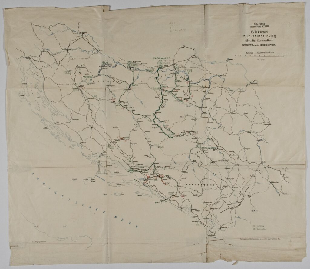
Paper, photolithography; 62.9 x 54.5 cm; scale: 1:1,000,000; u. r.: sheet nomenclature: ‘Tafel XXXV / (früher Tafel XXXIII).’; u. r.: title: ‘Skizze / zur Orientirung / über die Occupation / BOSNIEN'S und der HERCEGOVINA.’; l. l.: ‘Vervielfältigung vorbehalten.’; l. r.: ‘Photolitographie und Schnellpressendruck des k.u.k. militär-geogr. Institutes in Wien.’
Received from the 16th Imperial and Royal Varaždin Infantry Regiment
HPM/PMH-3794
This map depicts the most important military operations and planned attack routes during the Austro-Hungarian occupation of Bosnia and Herzegovina in 1878. On 13 July 1878, at the Congress of Berlin, the Austro-Hungarian Monarchy was given the right to occupy the territory of Bosnia and Herzegovina and establish its rule. Since the Muslims in Bosnia and Herzegovina were preparing to offer armed resistance, the Austro-Hungarian Army began military operations on 29 July 1878, crossing the border with Bosnia and Herzegovina in six places: Šamac, Brod, Gradiška, Kostajnica, Vrgorac, and Imotski. Military operations on the territory of Bosnia and Herzegovina were completed in October 1878. Bosnia and Herzegovina remained part of the Austro-Hungarian Monarchy until 1918, and the Austro-Hungarian administration left its mark on the political, economic, and social life of that time. This included cartographical work, through new geodetic surveys and the making of new maps under the leadership of Austrian cartographers.

This map depicts the most important military operations and planned attack routes during the Austro-Hungarian occupation of Bosnia and Herzegovina in 1878. On 13 July 1878, at the Congress of Berlin, the Austro-Hungarian Monarchy was given the right to occupy the territory of Bosnia and Herzegovina and establish its rule. Since the Muslims in Bosnia and Herzegovina were preparing to offer armed resistance, the Austro-Hungarian Army began military operations on 29 July 1878, crossing the border with Bosnia and Herzegovina in six places: Šamac, Brod, Gradiška, Kostajnica, Vrgorac, and Imotski. Military operations on the territory of Bosnia and Herzegovina were completed in October 1878. Bosnia and Herzegovina remained part of the Austro-Hungarian Monarchy until 1918, and the Austro-Hungarian administration left its mark on the political, economic, and social life of that time. This included cartographical work, through new geodetic surveys and the making of new maps under the leadership of Austrian cartographers.
This map depicts the most important military operations and planned attack routes during the Austro-Hungarian occupation of Bosnia and Herzegovina in 1878. On 13 July 1878, at the Congress of Berlin, the Austro-Hungarian Monarchy was given the right to occupy the territory of Bosnia and Herzegovina and establish its rule. Since the Muslims in Bosnia and Herzegovina were preparing to offer armed resistance, the Austro-Hungarian Army began military operations on 29 July 1878, crossing the border with Bosnia and Herzegovina in six places: Šamac, Brod, Gradiška, Kostajnica, Vrgorac, and Imotski. Military operations on the territory of Bosnia and Herzegovina were completed in October 1878. Bosnia and Herzegovina remained part of the Austro-Hungarian Monarchy until 1918, and the Austro-Hungarian administration left its mark on the political, economic, and social life of that time. This included cartographical work, through new geodetic surveys and the making of new maps under the leadership of Austrian cartographers.