Paper, print, manuscript, watercolour; 58 × 70 cm; scale: undetermined; title in centre: ‘PREGLEDNI LIST / za karte razmere 1:50.000, 1:100.000 i 1:200.000 / IZDANJA GEOGRAFSKOG INSTITUTA J.A’, u. r.: ‘Dužine lukova za pojedine / stepene po paraleli i po me- / ridijanu u km.’, l. r.: ‘Izrađeno i reproduktovano u G.I.J.A.’
Found in the Museum
HPM-101415
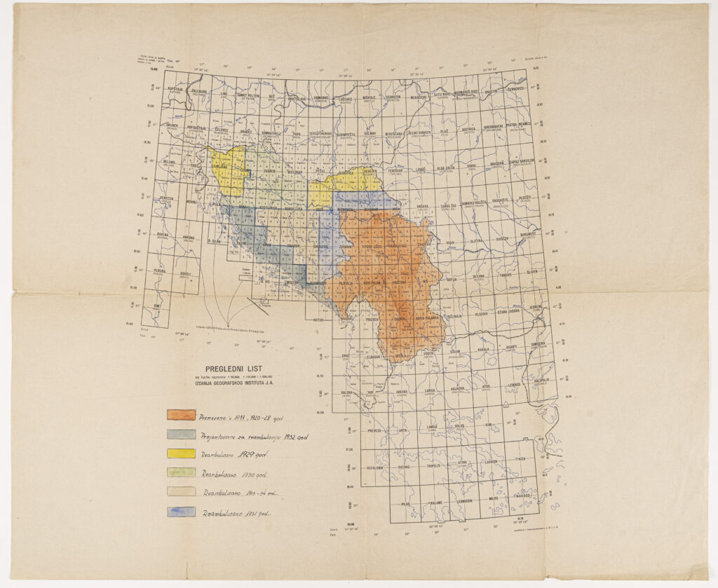
Overview sheet with depiction and nomenclature of topographic map sheets of central and southeastern Europe in 1:50,000, 1:100,000, and 1:200,000 scale. The revision of the territory of the Federal People’s Republic of Yugoslavia is marked by year, using a full colour map key: the area of central, western, southern, and eastern Serbia and Macedonia was revised in 1911 and again in the period from 1920 to 1928; the greater part of Slovenia and of eastern Croatia (from Slavonski Brod eastwards), Baranja, Vojvodina, and a part of southern Hungary were revised in 1929; the area of northern, central, and part of eastern Croatia up to Požega as well as a part of the Croatian Littoral with the island of Krk in 1930; the Croatian Littoral with the island of Rab, Dalmatia, Herzegovina, and Montenegro in 1931; the area of Srijem, eastern and southern Bosnia, and northern Serbia in 1932; and the greater part of Bosnia’s territory in the period from 1933 to 1934.

Overview sheet with depiction and nomenclature of topographic map sheets of central and southeastern Europe in 1:50,000, 1:100,000, and 1:200,000 scale. The revision of the territory of the Federal People’s Republic of Yugoslavia is marked by year, using a full colour map key: the area of central, western, southern, and eastern Serbia and Macedonia was revised in 1911 and again in the period from 1920 to 1928; the greater part of Slovenia and of eastern Croatia (from Slavonski Brod eastwards), Baranja, Vojvodina, and a part of southern Hungary were revised in 1929; the area of northern, central, and part of eastern Croatia up to Požega as well as a part of the Croatian Littoral with the island of Krk in 1930; the Croatian Littoral with the island of Rab, Dalmatia, Herzegovina, and Montenegro in 1931; the area of Srijem, eastern and southern Bosnia, and northern Serbia in 1932; and the greater part of Bosnia’s territory in the period from 1933 to 1934.
Overview sheet with depiction and nomenclature of topographic map sheets of central and southeastern Europe in 1:50,000, 1:100,000, and 1:200,000 scale. The revision of the territory of the Federal People’s Republic of Yugoslavia is marked by year, using a full colour map key: the area of central, western, southern, and eastern Serbia and Macedonia was revised in 1911 and again in the period from 1920 to 1928; the greater part of Slovenia and of eastern Croatia (from Slavonski Brod eastwards), Baranja, Vojvodina, and a part of southern Hungary were revised in 1929; the area of northern, central, and part of eastern Croatia up to Požega as well as a part of the Croatian Littoral with the island of Krk in 1930; the Croatian Littoral with the island of Rab, Dalmatia, Herzegovina, and Montenegro in 1931; the area of Srijem, eastern and southern Bosnia, and northern Serbia in 1932; and the greater part of Bosnia’s territory in the period from 1933 to 1934.