Paper, full colour print; height from 64.3 to 68.5 cm, breadth from 49.2 to 50 cm; scale: 1:100,000; u. l. and u. r. on individual sheets: ‘Karte von Jugoslawien 1:100 000’, ‘Sonderausgabe! / Nur für den Dienstgebrauch!’; l. r. and l. l.: ‘Reambulirao, iscrtao i reproduktovao Vojni Geografski Institut Kraljevine S.H.S.’; ‘Reambulirao, iscrtao i reproduktovao Vojni Geografski Institut Kraljevine Jugoslavije’; l. l. on reverse of individual maps: round seal: ‘INSTITUT ZA FIZIČKU GEOGRAFIJU / ZAGREB / SVEUČILIŠTE KRALJEVINE S.H.S.’; l. l. on individual maps in German: note on distances
Purchased in 1996
HPM/PMH-22895 – HPM/PMH-22897, HPM/PMH-22900 – HPM/PMH-22905, HPM/PMH-22907 – HPM/PMH-22909, HPM/PMH-22911, HPM/PMH-22913-22914, HPM/PMH-22929, HPM/PMH-26077
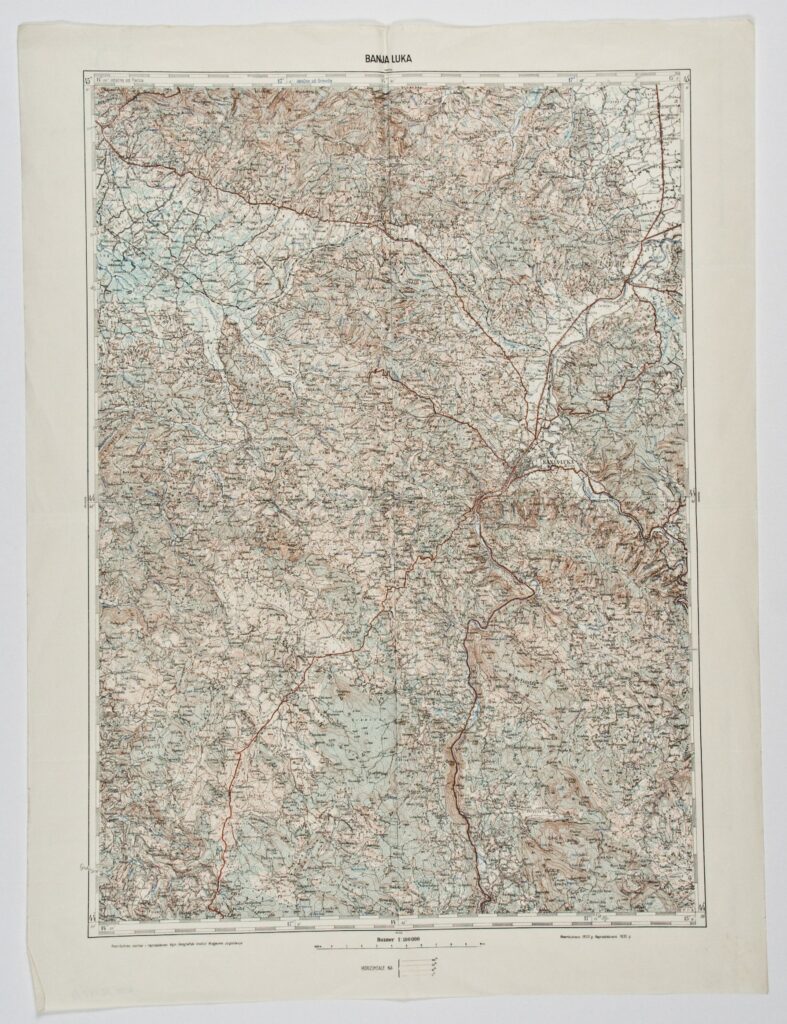
A minority of the topographic map sheets in 1:100,000 scale from the time of the Kingdom of Serbs, Croats and Slovenes, and later the Kingdom of Yugoslavia, was purchased (HPM-32557/1-13), while the majority was found in the Museum (HPM/PMH-22895 – HPM/PMH-22897, HPM/PMH-22900 – HPM/PMH-22905, HPM/PMH-22907 – HPM/PMH-22909, HPM/PMH-22911, HPM/PMH-22913-22914, HPM/PMH-22929, HPM/PMH-26077). In the 1930s, the Military Geographical Institute worked on a common geodetic basis for the territory of the Kingdom of Yugoslavia and on a revision of the topographic maps of the former Imperial and Royal Military Geographical Institute in Vienna. Changes and supplements of Austrian maps resulted in the making of a topographic map of the whole of Yugoslavia in 1:100,000 scale, in polyhedral projection, in the period from 1923 to 1939. The newly-made map was created on the basis of the survey conducted in 1:50,000 scale. In terms of contents, the 1:100,000 scale map is a topographic map that was also called a special map until World War II, and was made for military as well as civilian needs, which is why its printing and use were unlimited. This was the only precise map used by all belligerent sides during World War II for planning and preparing military operations in Southeastern Europe, and it also served as a source for making new maps.

A minority of the topographic map sheets in 1:100,000 scale from the time of the Kingdom of Serbs, Croats and Slovenes, and later the Kingdom of Yugoslavia, was purchased (HPM-32557/1-13), while the majority was found in the Museum (HPM/PMH-22895 – HPM/PMH-22897, HPM/PMH-22900 – HPM/PMH-22905, HPM/PMH-22907 – HPM/PMH-22909, HPM/PMH-22911, HPM/PMH-22913-22914, HPM/PMH-22929, HPM/PMH-26077). In the 1930s, the Military Geographical Institute worked on a common geodetic basis for the territory of the Kingdom of Yugoslavia and on a revision of the topographic maps of the former Imperial and Royal Military Geographical Institute in Vienna. Changes and supplements of Austrian maps resulted in the making of a topographic map of the whole of Yugoslavia in 1:100,000 scale, in polyhedral projection, in the period from 1923 to 1939. The newly-made map was created on the basis of the survey conducted in 1:50,000 scale. In terms of contents, the 1:100,000 scale map is a topographic map that was also called a special map until World War II, and was made for military as well as civilian needs, which is why its printing and use were unlimited. This was the only precise map used by all belligerent sides during World War II for planning and preparing military operations in Southeastern Europe, and it also served as a source for making new maps.
A minority of the topographic map sheets in 1:100,000 scale from the time of the Kingdom of Serbs, Croats and Slovenes, and later the Kingdom of Yugoslavia, was purchased (HPM-32557/1-13), while the majority was found in the Museum (HPM/PMH-22895 – HPM/PMH-22897, HPM/PMH-22900 – HPM/PMH-22905, HPM/PMH-22907 – HPM/PMH-22909, HPM/PMH-22911, HPM/PMH-22913-22914, HPM/PMH-22929, HPM/PMH-26077). In the 1930s, the Military Geographical Institute worked on a common geodetic basis for the territory of the Kingdom of Yugoslavia and on a revision of the topographic maps of the former Imperial and Royal Military Geographical Institute in Vienna. Changes and supplements of Austrian maps resulted in the making of a topographic map of the whole of Yugoslavia in 1:100,000 scale, in polyhedral projection, in the period from 1923 to 1939. The newly-made map was created on the basis of the survey conducted in 1:50,000 scale. In terms of contents, the 1:100,000 scale map is a topographic map that was also called a special map until World War II, and was made for military as well as civilian needs, which is why its printing and use were unlimited. This was the only precise map used by all belligerent sides during World War II for planning and preparing military operations in Southeastern Europe, and it also served as a source for making new maps.
A minority of the topographic map sheets in 1:100,000 scale from the time of the Kingdom of Serbs, Croats and Slovenes, and later the Kingdom of Yugoslavia, was purchased (HPM-32557/1-13), while the majority was found in the Museum (HPM/PMH-22895 – HPM/PMH-22897, HPM/PMH-22900 – HPM/PMH-22905, HPM/PMH-22907 – HPM/PMH-22909, HPM/PMH-22911, HPM/PMH-22913-22914, HPM/PMH-22929, HPM/PMH-26077). In the 1930s, the Military Geographical Institute worked on a common geodetic basis for the territory of the Kingdom of Yugoslavia and on a revision of the topographic maps of the former Imperial and Royal Military Geographical Institute in Vienna. Changes and supplements of Austrian maps resulted in the making of a topographic map of the whole of Yugoslavia in 1:100,000 scale, in polyhedral projection, in the period from 1923 to 1939. The newly-made map was created on the basis of the survey conducted in 1:50,000 scale. In terms of contents, the 1:100,000 scale map is a topographic map that was also called a special map until World War II, and was made for military as well as civilian needs, which is why its printing and use were unlimited. This was the only precise map used by all belligerent sides during World War II for planning and preparing military operations in Southeastern Europe, and it also served as a source for making new maps.
A minority of the topographic map sheets in 1:100,000 scale from the time of the Kingdom of Serbs, Croats and Slovenes, and later the Kingdom of Yugoslavia, was purchased (HPM-32557/1-13), while the majority was found in the Museum (HPM/PMH-22895 – HPM/PMH-22897, HPM/PMH-22900 – HPM/PMH-22905, HPM/PMH-22907 – HPM/PMH-22909, HPM/PMH-22911, HPM/PMH-22913-22914, HPM/PMH-22929, HPM/PMH-26077). In the 1930s, the Military Geographical Institute worked on a common geodetic basis for the territory of the Kingdom of Yugoslavia and on a revision of the topographic maps of the former Imperial and Royal Military Geographical Institute in Vienna. Changes and supplements of Austrian maps resulted in the making of a topographic map of the whole of Yugoslavia in 1:100,000 scale, in polyhedral projection, in the period from 1923 to 1939. The newly-made map was created on the basis of the survey conducted in 1:50,000 scale. In terms of contents, the 1:100,000 scale map is a topographic map that was also called a special map until World War II, and was made for military as well as civilian needs, which is why its printing and use were unlimited. This was the only precise map used by all belligerent sides during World War II for planning and preparing military operations in Southeastern Europe, and it also served as a source for making new maps.
A minority of the topographic map sheets in 1:100,000 scale from the time of the Kingdom of Serbs, Croats and Slovenes, and later the Kingdom of Yugoslavia, was purchased (HPM-32557/1-13), while the majority was found in the Museum (HPM/PMH-22895 – HPM/PMH-22897, HPM/PMH-22900 – HPM/PMH-22905, HPM/PMH-22907 – HPM/PMH-22909, HPM/PMH-22911, HPM/PMH-22913-22914, HPM/PMH-22929, HPM/PMH-26077). In the 1930s, the Military Geographical Institute worked on a common geodetic basis for the territory of the Kingdom of Yugoslavia and on a revision of the topographic maps of the former Imperial and Royal Military Geographical Institute in Vienna. Changes and supplements of Austrian maps resulted in the making of a topographic map of the whole of Yugoslavia in 1:100,000 scale, in polyhedral projection, in the period from 1923 to 1939. The newly-made map was created on the basis of the survey conducted in 1:50,000 scale. In terms of contents, the 1:100,000 scale map is a topographic map that was also called a special map until World War II, and was made for military as well as civilian needs, which is why its printing and use were unlimited. This was the only precise map used by all belligerent sides during World War II for planning and preparing military operations in Southeastern Europe, and it also served as a source for making new maps.
A minority of the topographic map sheets in 1:100,000 scale from the time of the Kingdom of Serbs, Croats and Slovenes, and later the Kingdom of Yugoslavia, was purchased (HPM-32557/1-13), while the majority was found in the Museum (HPM/PMH-22895 – HPM/PMH-22897, HPM/PMH-22900 – HPM/PMH-22905, HPM/PMH-22907 – HPM/PMH-22909, HPM/PMH-22911, HPM/PMH-22913-22914, HPM/PMH-22929, HPM/PMH-26077). In the 1930s, the Military Geographical Institute worked on a common geodetic basis for the territory of the Kingdom of Yugoslavia and on a revision of the topographic maps of the former Imperial and Royal Military Geographical Institute in Vienna. Changes and supplements of Austrian maps resulted in the making of a topographic map of the whole of Yugoslavia in 1:100,000 scale, in polyhedral projection, in the period from 1923 to 1939. The newly-made map was created on the basis of the survey conducted in 1:50,000 scale. In terms of contents, the 1:100,000 scale map is a topographic map that was also called a special map until World War II, and was made for military as well as civilian needs, which is why its printing and use were unlimited. This was the only precise map used by all belligerent sides during World War II for planning and preparing military operations in Southeastern Europe, and it also served as a source for making new maps.
A minority of the topographic map sheets in 1:100,000 scale from the time of the Kingdom of Serbs, Croats and Slovenes, and later the Kingdom of Yugoslavia, was purchased (HPM-32557/1-13), while the majority was found in the Museum (HPM/PMH-22895 – HPM/PMH-22897, HPM/PMH-22900 – HPM/PMH-22905, HPM/PMH-22907 – HPM/PMH-22909, HPM/PMH-22911, HPM/PMH-22913-22914, HPM/PMH-22929, HPM/PMH-26077). In the 1930s, the Military Geographical Institute worked on a common geodetic basis for the territory of the Kingdom of Yugoslavia and on a revision of the topographic maps of the former Imperial and Royal Military Geographical Institute in Vienna. Changes and supplements of Austrian maps resulted in the making of a topographic map of the whole of Yugoslavia in 1:100,000 scale, in polyhedral projection, in the period from 1923 to 1939. The newly-made map was created on the basis of the survey conducted in 1:50,000 scale. In terms of contents, the 1:100,000 scale map is a topographic map that was also called a special map until World War II, and was made for military as well as civilian needs, which is why its printing and use were unlimited. This was the only precise map used by all belligerent sides during World War II for planning and preparing military operations in Southeastern Europe, and it also served as a source for making new maps.
A minority of the topographic map sheets in 1:100,000 scale from the time of the Kingdom of Serbs, Croats and Slovenes, and later the Kingdom of Yugoslavia, was purchased (HPM-32557/1-13), while the majority was found in the Museum (HPM/PMH-22895 – HPM/PMH-22897, HPM/PMH-22900 – HPM/PMH-22905, HPM/PMH-22907 – HPM/PMH-22909, HPM/PMH-22911, HPM/PMH-22913-22914, HPM/PMH-22929, HPM/PMH-26077). In the 1930s, the Military Geographical Institute worked on a common geodetic basis for the territory of the Kingdom of Yugoslavia and on a revision of the topographic maps of the former Imperial and Royal Military Geographical Institute in Vienna. Changes and supplements of Austrian maps resulted in the making of a topographic map of the whole of Yugoslavia in 1:100,000 scale, in polyhedral projection, in the period from 1923 to 1939. The newly-made map was created on the basis of the survey conducted in 1:50,000 scale. In terms of contents, the 1:100,000 scale map is a topographic map that was also called a special map until World War II, and was made for military as well as civilian needs, which is why its printing and use were unlimited. This was the only precise map used by all belligerent sides during World War II for planning and preparing military operations in Southeastern Europe, and it also served as a source for making new maps.
A minority of the topographic map sheets in 1:100,000 scale from the time of the Kingdom of Serbs, Croats and Slovenes, and later the Kingdom of Yugoslavia, was purchased (HPM-32557/1-13), while the majority was found in the Museum (HPM/PMH-22895 – HPM/PMH-22897, HPM/PMH-22900 – HPM/PMH-22905, HPM/PMH-22907 – HPM/PMH-22909, HPM/PMH-22911, HPM/PMH-22913-22914, HPM/PMH-22929, HPM/PMH-26077). In the 1930s, the Military Geographical Institute worked on a common geodetic basis for the territory of the Kingdom of Yugoslavia and on a revision of the topographic maps of the former Imperial and Royal Military Geographical Institute in Vienna. Changes and supplements of Austrian maps resulted in the making of a topographic map of the whole of Yugoslavia in 1:100,000 scale, in polyhedral projection, in the period from 1923 to 1939. The newly-made map was created on the basis of the survey conducted in 1:50,000 scale. In terms of contents, the 1:100,000 scale map is a topographic map that was also called a special map until World War II, and was made for military as well as civilian needs, which is why its printing and use were unlimited. This was the only precise map used by all belligerent sides during World War II for planning and preparing military operations in Southeastern Europe, and it also served as a source for making new maps.
A minority of the topographic map sheets in 1:100,000 scale from the time of the Kingdom of Serbs, Croats and Slovenes, and later the Kingdom of Yugoslavia, was purchased (HPM-32557/1-13), while the majority was found in the Museum (HPM/PMH-22895 – HPM/PMH-22897, HPM/PMH-22900 – HPM/PMH-22905, HPM/PMH-22907 – HPM/PMH-22909, HPM/PMH-22911, HPM/PMH-22913-22914, HPM/PMH-22929, HPM/PMH-26077). In the 1930s, the Military Geographical Institute worked on a common geodetic basis for the territory of the Kingdom of Yugoslavia and on a revision of the topographic maps of the former Imperial and Royal Military Geographical Institute in Vienna. Changes and supplements of Austrian maps resulted in the making of a topographic map of the whole of Yugoslavia in 1:100,000 scale, in polyhedral projection, in the period from 1923 to 1939. The newly-made map was created on the basis of the survey conducted in 1:50,000 scale. In terms of contents, the 1:100,000 scale map is a topographic map that was also called a special map until World War II, and was made for military as well as civilian needs, which is why its printing and use were unlimited. This was the only precise map used by all belligerent sides during World War II for planning and preparing military operations in Southeastern Europe, and it also served as a source for making new maps.
A minority of the topographic map sheets in 1:100,000 scale from the time of the Kingdom of Serbs, Croats and Slovenes, and later the Kingdom of Yugoslavia, was purchased (HPM-32557/1-13), while the majority was found in the Museum (HPM/PMH-22895 – HPM/PMH-22897, HPM/PMH-22900 – HPM/PMH-22905, HPM/PMH-22907 – HPM/PMH-22909, HPM/PMH-22911, HPM/PMH-22913-22914, HPM/PMH-22929, HPM/PMH-26077). In the 1930s, the Military Geographical Institute worked on a common geodetic basis for the territory of the Kingdom of Yugoslavia and on a revision of the topographic maps of the former Imperial and Royal Military Geographical Institute in Vienna. Changes and supplements of Austrian maps resulted in the making of a topographic map of the whole of Yugoslavia in 1:100,000 scale, in polyhedral projection, in the period from 1923 to 1939. The newly-made map was created on the basis of the survey conducted in 1:50,000 scale. In terms of contents, the 1:100,000 scale map is a topographic map that was also called a special map until World War II, and was made for military as well as civilian needs, which is why its printing and use were unlimited. This was the only precise map used by all belligerent sides during World War II for planning and preparing military operations in Southeastern Europe, and it also served as a source for making new maps.
A minority of the topographic map sheets in 1:100,000 scale from the time of the Kingdom of Serbs, Croats and Slovenes, and later the Kingdom of Yugoslavia, was purchased (HPM-32557/1-13), while the majority was found in the Museum (HPM/PMH-22895 – HPM/PMH-22897, HPM/PMH-22900 – HPM/PMH-22905, HPM/PMH-22907 – HPM/PMH-22909, HPM/PMH-22911, HPM/PMH-22913-22914, HPM/PMH-22929, HPM/PMH-26077). In the 1930s, the Military Geographical Institute worked on a common geodetic basis for the territory of the Kingdom of Yugoslavia and on a revision of the topographic maps of the former Imperial and Royal Military Geographical Institute in Vienna. Changes and supplements of Austrian maps resulted in the making of a topographic map of the whole of Yugoslavia in 1:100,000 scale, in polyhedral projection, in the period from 1923 to 1939. The newly-made map was created on the basis of the survey conducted in 1:50,000 scale. In terms of contents, the 1:100,000 scale map is a topographic map that was also called a special map until World War II, and was made for military as well as civilian needs, which is why its printing and use were unlimited. This was the only precise map used by all belligerent sides during World War II for planning and preparing military operations in Southeastern Europe, and it also served as a source for making new maps.
A minority of the topographic map sheets in 1:100,000 scale from the time of the Kingdom of Serbs, Croats and Slovenes, and later the Kingdom of Yugoslavia, was purchased (HPM-32557/1-13), while the majority was found in the Museum (HPM/PMH-22895 – HPM/PMH-22897, HPM/PMH-22900 – HPM/PMH-22905, HPM/PMH-22907 – HPM/PMH-22909, HPM/PMH-22911, HPM/PMH-22913-22914, HPM/PMH-22929, HPM/PMH-26077). In the 1930s, the Military Geographical Institute worked on a common geodetic basis for the territory of the Kingdom of Yugoslavia and on a revision of the topographic maps of the former Imperial and Royal Military Geographical Institute in Vienna. Changes and supplements of Austrian maps resulted in the making of a topographic map of the whole of Yugoslavia in 1:100,000 scale, in polyhedral projection, in the period from 1923 to 1939. The newly-made map was created on the basis of the survey conducted in 1:50,000 scale. In terms of contents, the 1:100,000 scale map is a topographic map that was also called a special map until World War II, and was made for military as well as civilian needs, which is why its printing and use were unlimited. This was the only precise map used by all belligerent sides during World War II for planning and preparing military operations in Southeastern Europe, and it also served as a source for making new maps.
A minority of the topographic map sheets in 1:100,000 scale from the time of the Kingdom of Serbs, Croats and Slovenes, and later the Kingdom of Yugoslavia, was purchased (HPM-32557/1-13), while the majority was found in the Museum (HPM/PMH-22895 – HPM/PMH-22897, HPM/PMH-22900 – HPM/PMH-22905, HPM/PMH-22907 – HPM/PMH-22909, HPM/PMH-22911, HPM/PMH-22913-22914, HPM/PMH-22929, HPM/PMH-26077). In the 1930s, the Military Geographical Institute worked on a common geodetic basis for the territory of the Kingdom of Yugoslavia and on a revision of the topographic maps of the former Imperial and Royal Military Geographical Institute in Vienna. Changes and supplements of Austrian maps resulted in the making of a topographic map of the whole of Yugoslavia in 1:100,000 scale, in polyhedral projection, in the period from 1923 to 1939. The newly-made map was created on the basis of the survey conducted in 1:50,000 scale. In terms of contents, the 1:100,000 scale map is a topographic map that was also called a special map until World War II, and was made for military as well as civilian needs, which is why its printing and use were unlimited. This was the only precise map used by all belligerent sides during World War II for planning and preparing military operations in Southeastern Europe, and it also served as a source for making new maps.
A minority of the topographic map sheets in 1:100,000 scale from the time of the Kingdom of Serbs, Croats and Slovenes, and later the Kingdom of Yugoslavia, was purchased (HPM-32557/1-13), while the majority was found in the Museum (HPM/PMH-22895 – HPM/PMH-22897, HPM/PMH-22900 – HPM/PMH-22905, HPM/PMH-22907 – HPM/PMH-22909, HPM/PMH-22911, HPM/PMH-22913-22914, HPM/PMH-22929, HPM/PMH-26077). In the 1930s, the Military Geographical Institute worked on a common geodetic basis for the territory of the Kingdom of Yugoslavia and on a revision of the topographic maps of the former Imperial and Royal Military Geographical Institute in Vienna. Changes and supplements of Austrian maps resulted in the making of a topographic map of the whole of Yugoslavia in 1:100,000 scale, in polyhedral projection, in the period from 1923 to 1939. The newly-made map was created on the basis of the survey conducted in 1:50,000 scale. In terms of contents, the 1:100,000 scale map is a topographic map that was also called a special map until World War II, and was made for military as well as civilian needs, which is why its printing and use were unlimited. This was the only precise map used by all belligerent sides during World War II for planning and preparing military operations in Southeastern Europe, and it also served as a source for making new maps.
A minority of the topographic map sheets in 1:100,000 scale from the time of the Kingdom of Serbs, Croats and Slovenes, and later the Kingdom of Yugoslavia, was purchased (HPM-32557/1-13), while the majority was found in the Museum (HPM/PMH-22895 – HPM/PMH-22897, HPM/PMH-22900 – HPM/PMH-22905, HPM/PMH-22907 – HPM/PMH-22909, HPM/PMH-22911, HPM/PMH-22913-22914, HPM/PMH-22929, HPM/PMH-26077). In the 1930s, the Military Geographical Institute worked on a common geodetic basis for the territory of the Kingdom of Yugoslavia and on a revision of the topographic maps of the former Imperial and Royal Military Geographical Institute in Vienna. Changes and supplements of Austrian maps resulted in the making of a topographic map of the whole of Yugoslavia in 1:100,000 scale, in polyhedral projection, in the period from 1923 to 1939. The newly-made map was created on the basis of the survey conducted in 1:50,000 scale. In terms of contents, the 1:100,000 scale map is a topographic map that was also called a special map until World War II, and was made for military as well as civilian needs, which is why its printing and use were unlimited. This was the only precise map used by all belligerent sides during World War II for planning and preparing military operations in Southeastern Europe, and it also served as a source for making new maps.
A minority of the topographic map sheets in 1:100,000 scale from the time of the Kingdom of Serbs, Croats and Slovenes, and later the Kingdom of Yugoslavia, was purchased (HPM-32557/1-13), while the majority was found in the Museum (HPM/PMH-22895 – HPM/PMH-22897, HPM/PMH-22900 – HPM/PMH-22905, HPM/PMH-22907 – HPM/PMH-22909, HPM/PMH-22911, HPM/PMH-22913-22914, HPM/PMH-22929, HPM/PMH-26077). In the 1930s, the Military Geographical Institute worked on a common geodetic basis for the territory of the Kingdom of Yugoslavia and on a revision of the topographic maps of the former Imperial and Royal Military Geographical Institute in Vienna. Changes and supplements of Austrian maps resulted in the making of a topographic map of the whole of Yugoslavia in 1:100,000 scale, in polyhedral projection, in the period from 1923 to 1939. The newly-made map was created on the basis of the survey conducted in 1:50,000 scale. In terms of contents, the 1:100,000 scale map is a topographic map that was also called a special map until World War II, and was made for military as well as civilian needs, which is why its printing and use were unlimited. This was the only precise map used by all belligerent sides during World War II for planning and preparing military operations in Southeastern Europe, and it also served as a source for making new maps.
A minority of the topographic map sheets in 1:100,000 scale from the time of the Kingdom of Serbs, Croats and Slovenes, and later the Kingdom of Yugoslavia, was purchased (HPM-32557/1-13), while the majority was found in the Museum (HPM/PMH-22895 – HPM/PMH-22897, HPM/PMH-22900 – HPM/PMH-22905, HPM/PMH-22907 – HPM/PMH-22909, HPM/PMH-22911, HPM/PMH-22913-22914, HPM/PMH-22929, HPM/PMH-26077). In the 1930s, the Military Geographical Institute worked on a common geodetic basis for the territory of the Kingdom of Yugoslavia and on a revision of the topographic maps of the former Imperial and Royal Military Geographical Institute in Vienna. Changes and supplements of Austrian maps resulted in the making of a topographic map of the whole of Yugoslavia in 1:100,000 scale, in polyhedral projection, in the period from 1923 to 1939. The newly-made map was created on the basis of the survey conducted in 1:50,000 scale. In terms of contents, the 1:100,000 scale map is a topographic map that was also called a special map until World War II, and was made for military as well as civilian needs, which is why its printing and use were unlimited. This was the only precise map used by all belligerent sides during World War II for planning and preparing military operations in Southeastern Europe, and it also served as a source for making new maps.
A minority of the topographic map sheets in 1:100,000 scale from the time of the Kingdom of Serbs, Croats and Slovenes, and later the Kingdom of Yugoslavia, was purchased (HPM-32557/1-13), while the majority was found in the Museum (HPM/PMH-22895 – HPM/PMH-22897, HPM/PMH-22900 – HPM/PMH-22905, HPM/PMH-22907 – HPM/PMH-22909, HPM/PMH-22911, HPM/PMH-22913-22914, HPM/PMH-22929, HPM/PMH-26077). In the 1930s, the Military Geographical Institute worked on a common geodetic basis for the territory of the Kingdom of Yugoslavia and on a revision of the topographic maps of the former Imperial and Royal Military Geographical Institute in Vienna. Changes and supplements of Austrian maps resulted in the making of a topographic map of the whole of Yugoslavia in 1:100,000 scale, in polyhedral projection, in the period from 1923 to 1939. The newly-made map was created on the basis of the survey conducted in 1:50,000 scale. In terms of contents, the 1:100,000 scale map is a topographic map that was also called a special map until World War II, and was made for military as well as civilian needs, which is why its printing and use were unlimited. This was the only precise map used by all belligerent sides during World War II for planning and preparing military operations in Southeastern Europe, and it also served as a source for making new maps.
A minority of the topographic map sheets in 1:100,000 scale from the time of the Kingdom of Serbs, Croats and Slovenes, and later the Kingdom of Yugoslavia, was purchased (HPM-32557/1-13), while the majority was found in the Museum (HPM/PMH-22895 – HPM/PMH-22897, HPM/PMH-22900 – HPM/PMH-22905, HPM/PMH-22907 – HPM/PMH-22909, HPM/PMH-22911, HPM/PMH-22913-22914, HPM/PMH-22929, HPM/PMH-26077). In the 1930s, the Military Geographical Institute worked on a common geodetic basis for the territory of the Kingdom of Yugoslavia and on a revision of the topographic maps of the former Imperial and Royal Military Geographical Institute in Vienna. Changes and supplements of Austrian maps resulted in the making of a topographic map of the whole of Yugoslavia in 1:100,000 scale, in polyhedral projection, in the period from 1923 to 1939. The newly-made map was created on the basis of the survey conducted in 1:50,000 scale. In terms of contents, the 1:100,000 scale map is a topographic map that was also called a special map until World War II, and was made for military as well as civilian needs, which is why its printing and use were unlimited. This was the only precise map used by all belligerent sides during World War II for planning and preparing military operations in Southeastern Europe, and it also served as a source for making new maps.
A minority of the topographic map sheets in 1:100,000 scale from the time of the Kingdom of Serbs, Croats and Slovenes, and later the Kingdom of Yugoslavia, was purchased (HPM-32557/1-13), while the majority was found in the Museum (HPM/PMH-22895 – HPM/PMH-22897, HPM/PMH-22900 – HPM/PMH-22905, HPM/PMH-22907 – HPM/PMH-22909, HPM/PMH-22911, HPM/PMH-22913-22914, HPM/PMH-22929, HPM/PMH-26077). In the 1930s, the Military Geographical Institute worked on a common geodetic basis for the territory of the Kingdom of Yugoslavia and on a revision of the topographic maps of the former Imperial and Royal Military Geographical Institute in Vienna. Changes and supplements of Austrian maps resulted in the making of a topographic map of the whole of Yugoslavia in 1:100,000 scale, in polyhedral projection, in the period from 1923 to 1939. The newly-made map was created on the basis of the survey conducted in 1:50,000 scale. In terms of contents, the 1:100,000 scale map is a topographic map that was also called a special map until World War II, and was made for military as well as civilian needs, which is why its printing and use were unlimited. This was the only precise map used by all belligerent sides during World War II for planning and preparing military operations in Southeastern Europe, and it also served as a source for making new maps.
A minority of the topographic map sheets in 1:100,000 scale from the time of the Kingdom of Serbs, Croats and Slovenes, and later the Kingdom of Yugoslavia, was purchased (HPM-32557/1-13), while the majority was found in the Museum (HPM/PMH-22895 – HPM/PMH-22897, HPM/PMH-22900 – HPM/PMH-22905, HPM/PMH-22907 – HPM/PMH-22909, HPM/PMH-22911, HPM/PMH-22913-22914, HPM/PMH-22929, HPM/PMH-26077). In the 1930s, the Military Geographical Institute worked on a common geodetic basis for the territory of the Kingdom of Yugoslavia and on a revision of the topographic maps of the former Imperial and Royal Military Geographical Institute in Vienna. Changes and supplements of Austrian maps resulted in the making of a topographic map of the whole of Yugoslavia in 1:100,000 scale, in polyhedral projection, in the period from 1923 to 1939. The newly-made map was created on the basis of the survey conducted in 1:50,000 scale. In terms of contents, the 1:100,000 scale map is a topographic map that was also called a special map until World War II, and was made for military as well as civilian needs, which is why its printing and use were unlimited. This was the only precise map used by all belligerent sides during World War II for planning and preparing military operations in Southeastern Europe, and it also served as a source for making new maps.
A minority of the topographic map sheets in 1:100,000 scale from the time of the Kingdom of Serbs, Croats and Slovenes, and later the Kingdom of Yugoslavia, was purchased (HPM-32557/1-13), while the majority was found in the Museum (HPM/PMH-22895 – HPM/PMH-22897, HPM/PMH-22900 – HPM/PMH-22905, HPM/PMH-22907 – HPM/PMH-22909, HPM/PMH-22911, HPM/PMH-22913-22914, HPM/PMH-22929, HPM/PMH-26077). In the 1930s, the Military Geographical Institute worked on a common geodetic basis for the territory of the Kingdom of Yugoslavia and on a revision of the topographic maps of the former Imperial and Royal Military Geographical Institute in Vienna. Changes and supplements of Austrian maps resulted in the making of a topographic map of the whole of Yugoslavia in 1:100,000 scale, in polyhedral projection, in the period from 1923 to 1939. The newly-made map was created on the basis of the survey conducted in 1:50,000 scale. In terms of contents, the 1:100,000 scale map is a topographic map that was also called a special map until World War II, and was made for military as well as civilian needs, which is why its printing and use were unlimited. This was the only precise map used by all belligerent sides during World War II for planning and preparing military operations in Southeastern Europe, and it also served as a source for making new maps.
A minority of the topographic map sheets in 1:100,000 scale from the time of the Kingdom of Serbs, Croats and Slovenes, and later the Kingdom of Yugoslavia, was purchased (HPM-32557/1-13), while the majority was found in the Museum (HPM/PMH-22895 – HPM/PMH-22897, HPM/PMH-22900 – HPM/PMH-22905, HPM/PMH-22907 – HPM/PMH-22909, HPM/PMH-22911, HPM/PMH-22913-22914, HPM/PMH-22929, HPM/PMH-26077). In the 1930s, the Military Geographical Institute worked on a common geodetic basis for the territory of the Kingdom of Yugoslavia and on a revision of the topographic maps of the former Imperial and Royal Military Geographical Institute in Vienna. Changes and supplements of Austrian maps resulted in the making of a topographic map of the whole of Yugoslavia in 1:100,000 scale, in polyhedral projection, in the period from 1923 to 1939. The newly-made map was created on the basis of the survey conducted in 1:50,000 scale. In terms of contents, the 1:100,000 scale map is a topographic map that was also called a special map until World War II, and was made for military as well as civilian needs, which is why its printing and use were unlimited. This was the only precise map used by all belligerent sides during World War II for planning and preparing military operations in Southeastern Europe, and it also served as a source for making new maps.
A minority of the topographic map sheets in 1:100,000 scale from the time of the Kingdom of Serbs, Croats and Slovenes, and later the Kingdom of Yugoslavia, was purchased (HPM-32557/1-13), while the majority was found in the Museum (HPM/PMH-22895 – HPM/PMH-22897, HPM/PMH-22900 – HPM/PMH-22905, HPM/PMH-22907 – HPM/PMH-22909, HPM/PMH-22911, HPM/PMH-22913-22914, HPM/PMH-22929, HPM/PMH-26077). In the 1930s, the Military Geographical Institute worked on a common geodetic basis for the territory of the Kingdom of Yugoslavia and on a revision of the topographic maps of the former Imperial and Royal Military Geographical Institute in Vienna. Changes and supplements of Austrian maps resulted in the making of a topographic map of the whole of Yugoslavia in 1:100,000 scale, in polyhedral projection, in the period from 1923 to 1939. The newly-made map was created on the basis of the survey conducted in 1:50,000 scale. In terms of contents, the 1:100,000 scale map is a topographic map that was also called a special map until World War II, and was made for military as well as civilian needs, which is why its printing and use were unlimited. This was the only precise map used by all belligerent sides during World War II for planning and preparing military operations in Southeastern Europe, and it also served as a source for making new maps.
A minority of the topographic map sheets in 1:100,000 scale from the time of the Kingdom of Serbs, Croats and Slovenes, and later the Kingdom of Yugoslavia, was purchased (HPM-32557/1-13), while the majority was found in the Museum (HPM/PMH-22895 – HPM/PMH-22897, HPM/PMH-22900 – HPM/PMH-22905, HPM/PMH-22907 – HPM/PMH-22909, HPM/PMH-22911, HPM/PMH-22913-22914, HPM/PMH-22929, HPM/PMH-26077). In the 1930s, the Military Geographical Institute worked on a common geodetic basis for the territory of the Kingdom of Yugoslavia and on a revision of the topographic maps of the former Imperial and Royal Military Geographical Institute in Vienna. Changes and supplements of Austrian maps resulted in the making of a topographic map of the whole of Yugoslavia in 1:100,000 scale, in polyhedral projection, in the period from 1923 to 1939. The newly-made map was created on the basis of the survey conducted in 1:50,000 scale. In terms of contents, the 1:100,000 scale map is a topographic map that was also called a special map until World War II, and was made for military as well as civilian needs, which is why its printing and use were unlimited. This was the only precise map used by all belligerent sides during World War II for planning and preparing military operations in Southeastern Europe, and it also served as a source for making new maps.
A minority of the topographic map sheets in 1:100,000 scale from the time of the Kingdom of Serbs, Croats and Slovenes, and later the Kingdom of Yugoslavia, was purchased (HPM-32557/1-13), while the majority was found in the Museum (HPM/PMH-22895 – HPM/PMH-22897, HPM/PMH-22900 – HPM/PMH-22905, HPM/PMH-22907 – HPM/PMH-22909, HPM/PMH-22911, HPM/PMH-22913-22914, HPM/PMH-22929, HPM/PMH-26077). In the 1930s, the Military Geographical Institute worked on a common geodetic basis for the territory of the Kingdom of Yugoslavia and on a revision of the topographic maps of the former Imperial and Royal Military Geographical Institute in Vienna. Changes and supplements of Austrian maps resulted in the making of a topographic map of the whole of Yugoslavia in 1:100,000 scale, in polyhedral projection, in the period from 1923 to 1939. The newly-made map was created on the basis of the survey conducted in 1:50,000 scale. In terms of contents, the 1:100,000 scale map is a topographic map that was also called a special map until World War II, and was made for military as well as civilian needs, which is why its printing and use were unlimited. This was the only precise map used by all belligerent sides during World War II for planning and preparing military operations in Southeastern Europe, and it also served as a source for making new maps.
A minority of the topographic map sheets in 1:100,000 scale from the time of the Kingdom of Serbs, Croats and Slovenes, and later the Kingdom of Yugoslavia, was purchased (HPM-32557/1-13), while the majority was found in the Museum (HPM/PMH-22895 – HPM/PMH-22897, HPM/PMH-22900 – HPM/PMH-22905, HPM/PMH-22907 – HPM/PMH-22909, HPM/PMH-22911, HPM/PMH-22913-22914, HPM/PMH-22929, HPM/PMH-26077). In the 1930s, the Military Geographical Institute worked on a common geodetic basis for the territory of the Kingdom of Yugoslavia and on a revision of the topographic maps of the former Imperial and Royal Military Geographical Institute in Vienna. Changes and supplements of Austrian maps resulted in the making of a topographic map of the whole of Yugoslavia in 1:100,000 scale, in polyhedral projection, in the period from 1923 to 1939. The newly-made map was created on the basis of the survey conducted in 1:50,000 scale. In terms of contents, the 1:100,000 scale map is a topographic map that was also called a special map until World War II, and was made for military as well as civilian needs, which is why its printing and use were unlimited. This was the only precise map used by all belligerent sides during World War II for planning and preparing military operations in Southeastern Europe, and it also served as a source for making new maps.
A minority of the topographic map sheets in 1:100,000 scale from the time of the Kingdom of Serbs, Croats and Slovenes, and later the Kingdom of Yugoslavia, was purchased (HPM-32557/1-13), while the majority was found in the Museum (HPM/PMH-22895 – HPM/PMH-22897, HPM/PMH-22900 – HPM/PMH-22905, HPM/PMH-22907 – HPM/PMH-22909, HPM/PMH-22911, HPM/PMH-22913-22914, HPM/PMH-22929, HPM/PMH-26077). In the 1930s, the Military Geographical Institute worked on a common geodetic basis for the territory of the Kingdom of Yugoslavia and on a revision of the topographic maps of the former Imperial and Royal Military Geographical Institute in Vienna. Changes and supplements of Austrian maps resulted in the making of a topographic map of the whole of Yugoslavia in 1:100,000 scale, in polyhedral projection, in the period from 1923 to 1939. The newly-made map was created on the basis of the survey conducted in 1:50,000 scale. In terms of contents, the 1:100,000 scale map is a topographic map that was also called a special map until World War II, and was made for military as well as civilian needs, which is why its printing and use were unlimited. This was the only precise map used by all belligerent sides during World War II for planning and preparing military operations in Southeastern Europe, and it also served as a source for making new maps.
A minority of the topographic map sheets in 1:100,000 scale from the time of the Kingdom of Serbs, Croats and Slovenes, and later the Kingdom of Yugoslavia, was purchased (HPM-32557/1-13), while the majority was found in the Museum (HPM/PMH-22895 – HPM/PMH-22897, HPM/PMH-22900 – HPM/PMH-22905, HPM/PMH-22907 – HPM/PMH-22909, HPM/PMH-22911, HPM/PMH-22913-22914, HPM/PMH-22929, HPM/PMH-26077). In the 1930s, the Military Geographical Institute worked on a common geodetic basis for the territory of the Kingdom of Yugoslavia and on a revision of the topographic maps of the former Imperial and Royal Military Geographical Institute in Vienna. Changes and supplements of Austrian maps resulted in the making of a topographic map of the whole of Yugoslavia in 1:100,000 scale, in polyhedral projection, in the period from 1923 to 1939. The newly-made map was created on the basis of the survey conducted in 1:50,000 scale. In terms of contents, the 1:100,000 scale map is a topographic map that was also called a special map until World War II, and was made for military as well as civilian needs, which is why its printing and use were unlimited. This was the only precise map used by all belligerent sides during World War II for planning and preparing military operations in Southeastern Europe, and it also served as a source for making new maps.
A minority of the topographic map sheets in 1:100,000 scale from the time of the Kingdom of Serbs, Croats and Slovenes, and later the Kingdom of Yugoslavia, was purchased (HPM-32557/1-13), while the majority was found in the Museum (HPM/PMH-22895 – HPM/PMH-22897, HPM/PMH-22900 – HPM/PMH-22905, HPM/PMH-22907 – HPM/PMH-22909, HPM/PMH-22911, HPM/PMH-22913-22914, HPM/PMH-22929, HPM/PMH-26077). In the 1930s, the Military Geographical Institute worked on a common geodetic basis for the territory of the Kingdom of Yugoslavia and on a revision of the topographic maps of the former Imperial and Royal Military Geographical Institute in Vienna. Changes and supplements of Austrian maps resulted in the making of a topographic map of the whole of Yugoslavia in 1:100,000 scale, in polyhedral projection, in the period from 1923 to 1939. The newly-made map was created on the basis of the survey conducted in 1:50,000 scale. In terms of contents, the 1:100,000 scale map is a topographic map that was also called a special map until World War II, and was made for military as well as civilian needs, which is why its printing and use were unlimited. This was the only precise map used by all belligerent sides during World War II for planning and preparing military operations in Southeastern Europe, and it also served as a source for making new maps.