Paper on canvas, full colour print; from 40.1 x 58 cm to 45.3 x 59.5 cm; paper, print; from 38 x 53.3 cm to 48 x 61.5 cm; ; scale: 1:75,000; sheet titles and nomenclature above map frames; names of sheet makers and producers, map key, and publisher data on individual sheets: ‘K.k. militär-geografisches Institut. / Vervielfältigung vorbehalten.’; ‘General-Depot: R. Lechner's k.k. Hof=und Universitäts-Buchandlung Wien, Graben 31.’; round stamp on reverse of individual sheets: ‘NEZAVISNA DRŽAVA HRVATSKA / MINISTARSTVO ORUŽANIH SNAGA / RATNI ARHIV’
Inherited from the War Archive and Museum of the ISC
HPM/PMH-5363 - HPM/PMH-11963
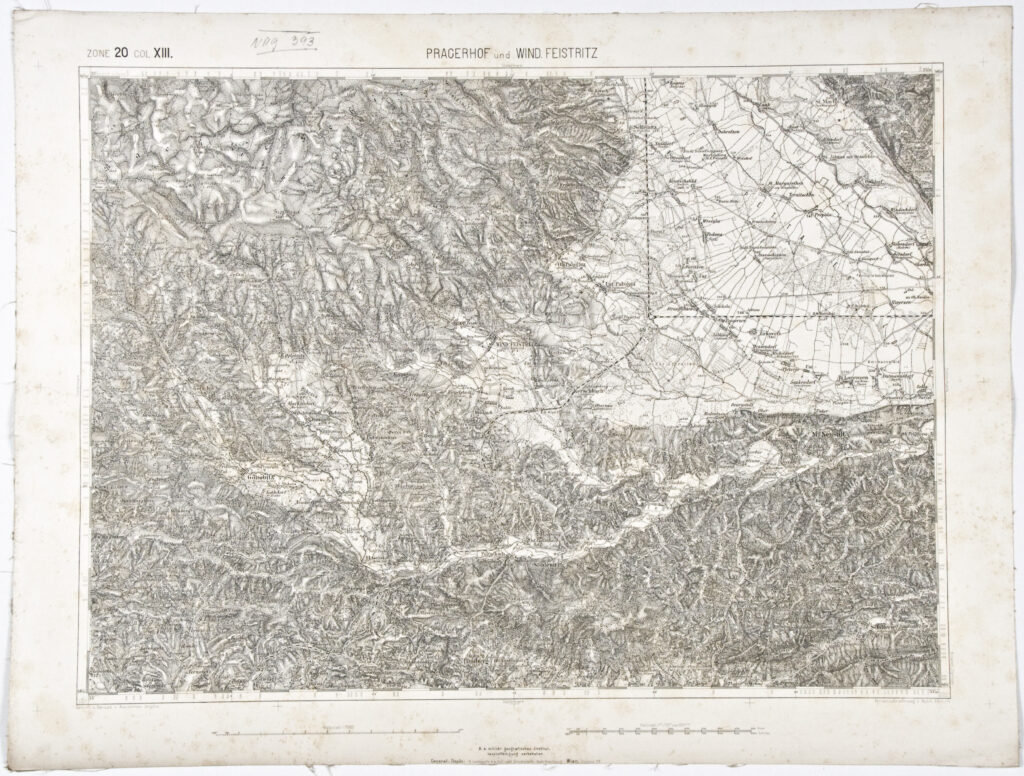
Of the 94 sheets of the special (topographic) map of the Austro-Hungarian Monarchy (‘Spezialkarte der Osterreichisch-Ungarischen Monarchie’), published in various years during the third topographic survey of the Austro-Hungarian Monarchy (1869–1887) and kept as part of the Cartographical Collection’s holdings, the majority were inherited from the War Archive and Museum of the ISC (HPM/PMH-5363, HPM/PMH-5364/2, HPM/PMH-5365/2 – HPM/PMH-5366, HPM/PMH-5368 – HPM/PMH-5375/2, HPM/PMH-5376, HPM/PMH-5379 – HPM/PMH-5380/1, HPM/PMH-5382/2, HPM/PMH-5383/2, HPM/PMH-5385, HPM/PMH-5386, HPM/PMH-5387/2, HPM/PMH-5388 – HPM/PMH-5389, HPM/PMH-5390/2 – HPM/PMH-5398, HPM/PMH-5400 – HPM/PMH-5402, HPM/PMH-5404/2, HPM/PMH-5405 – HPM/PMH-5407, HPM/PMH-5410/1, HPM/PMH-5413 – HPM/PMH-5414, HPM/PMH-5416 – HPM/PMH-5417, HPM/PMH-5421 – HPM/PMH-5422, HPM/PMH-5425, HPM/PMH-5427 – HPM/PMH-5428, HPM/PMH-5432 – HPM/PMH-5434, HPM/PMH-5436 – HPM/PMH-5438, HPM/PMH-19774, HPM/PMH-19752, HPM/PMH-19764, HPM/PMH-24774 – HPM/PMH-24776, HPM/PMH-24781 – HPM/PMH-24786, HPM/PMH-24788 – HPM/PMH-24789/b, HPM/PMH-24791 – HPM/PMH-24796, HPM/PMH-24799 – HPM/PMH-24801, HPM/PMH-24803, HPM/PMH-24811, HPM/PMH-24814), while a smaller number were purchased in 1958 (HPM/PMH-7473, HPM/PMH-7481 – HPM/PMH-7482) or found in the museum (HPM/PMH-11955/b – HPM/PMH-11956, HPM/PMH-11961, HPM/PMH-11963). According to the accepted division of topographic maps sheets in 1:75,000 scale used in the entire Austro-Hungarian Monarchy, each map sheet was individually named and numbered with zone (Zone) and column (Colonne) numbers for ease of use as well as orientation. Relief was depicted on maps using the Lehmann method of hatching (hachures or lines were used to mark slopes in the landscape) used on topographic maps of the Austro-Hungarian Monarchy of the Franciscan and Franz-Josephinian surveys. This method of depicting relief on maps remained in use until the beginning of World War I. Along with a multitude of toponyms, the sheets depict the road and railway network. Among the presented cartographical material, a sheet of the special map of the Austrian-Italian border area of Sessana and San Pietro can be highlighted. It was once kept in the library of the infantry cadet school in Kamenitz (today Sremska Kamenica) near Petrovaradin, and served as a teaching aid for training cadets.

Of the 94 sheets of the special (topographic) map of the Austro-Hungarian Monarchy (‘Spezialkarte der Osterreichisch-Ungarischen Monarchie’), published in various years during the third topographic survey of the Austro-Hungarian Monarchy (1869–1887) and kept as part of the Cartographical Collection’s holdings, the majority were inherited from the War Archive and Museum of the ISC (HPM/PMH-5363, HPM/PMH-5364/2, HPM/PMH-5365/2 – HPM/PMH-5366, HPM/PMH-5368 – HPM/PMH-5375/2, HPM/PMH-5376, HPM/PMH-5379 – HPM/PMH-5380/1, HPM/PMH-5382/2, HPM/PMH-5383/2, HPM/PMH-5385, HPM/PMH-5386, HPM/PMH-5387/2, HPM/PMH-5388 – HPM/PMH-5389, HPM/PMH-5390/2 – HPM/PMH-5398, HPM/PMH-5400 – HPM/PMH-5402, HPM/PMH-5404/2, HPM/PMH-5405 – HPM/PMH-5407, HPM/PMH-5410/1, HPM/PMH-5413 – HPM/PMH-5414, HPM/PMH-5416 – HPM/PMH-5417, HPM/PMH-5421 – HPM/PMH-5422, HPM/PMH-5425, HPM/PMH-5427 – HPM/PMH-5428, HPM/PMH-5432 – HPM/PMH-5434, HPM/PMH-5436 – HPM/PMH-5438, HPM/PMH-19774, HPM/PMH-19752, HPM/PMH-19764, HPM/PMH-24774 – HPM/PMH-24776, HPM/PMH-24781 – HPM/PMH-24786, HPM/PMH-24788 – HPM/PMH-24789/b, HPM/PMH-24791 – HPM/PMH-24796, HPM/PMH-24799 – HPM/PMH-24801, HPM/PMH-24803, HPM/PMH-24811, HPM/PMH-24814), while a smaller number were purchased in 1958 (HPM/PMH-7473, HPM/PMH-7481 – HPM/PMH-7482) or found in the museum (HPM/PMH-11955/b – HPM/PMH-11956, HPM/PMH-11961, HPM/PMH-11963). According to the accepted division of topographic maps sheets in 1:75,000 scale used in the entire Austro-Hungarian Monarchy, each map sheet was individually named and numbered with zone (Zone) and column (Colonne) numbers for ease of use as well as orientation. Relief was depicted on maps using the Lehmann method of hatching (hachures or lines were used to mark slopes in the landscape) used on topographic maps of the Austro-Hungarian Monarchy of the Franciscan and Franz-Josephinian surveys. This method of depicting relief on maps remained in use until the beginning of World War I. Along with a multitude of toponyms, the sheets depict the road and railway network. Among the presented cartographical material, a sheet of the special map of the Austrian-Italian border area of Sessana and San Pietro can be highlighted. It was once kept in the library of the infantry cadet school in Kamenitz (today Sremska Kamenica) near Petrovaradin, and served as a teaching aid for training cadets.
Of the 94 sheets of the special (topographic) map of the Austro-Hungarian Monarchy (‘Spezialkarte der Osterreichisch-Ungarischen Monarchie’), published in various years during the third topographic survey of the Austro-Hungarian Monarchy (1869–1887) and kept as part of the Cartographical Collection’s holdings, the majority were inherited from the War Archive and Museum of the ISC (HPM/PMH-5363, HPM/PMH-5364/2, HPM/PMH-5365/2 – HPM/PMH-5366, HPM/PMH-5368 – HPM/PMH-5375/2, HPM/PMH-5376, HPM/PMH-5379 – HPM/PMH-5380/1, HPM/PMH-5382/2, HPM/PMH-5383/2, HPM/PMH-5385, HPM/PMH-5386, HPM/PMH-5387/2, HPM/PMH-5388 – HPM/PMH-5389, HPM/PMH-5390/2 – HPM/PMH-5398, HPM/PMH-5400 – HPM/PMH-5402, HPM/PMH-5404/2, HPM/PMH-5405 – HPM/PMH-5407, HPM/PMH-5410/1, HPM/PMH-5413 – HPM/PMH-5414, HPM/PMH-5416 – HPM/PMH-5417, HPM/PMH-5421 – HPM/PMH-5422, HPM/PMH-5425, HPM/PMH-5427 – HPM/PMH-5428, HPM/PMH-5432 – HPM/PMH-5434, HPM/PMH-5436 – HPM/PMH-5438, HPM/PMH-19774, HPM/PMH-19752, HPM/PMH-19764, HPM/PMH-24774 – HPM/PMH-24776, HPM/PMH-24781 – HPM/PMH-24786, HPM/PMH-24788 – HPM/PMH-24789/b, HPM/PMH-24791 – HPM/PMH-24796, HPM/PMH-24799 – HPM/PMH-24801, HPM/PMH-24803, HPM/PMH-24811, HPM/PMH-24814), while a smaller number were purchased in 1958 (HPM/PMH-7473, HPM/PMH-7481 – HPM/PMH-7482) or found in the museum (HPM/PMH-11955/b – HPM/PMH-11956, HPM/PMH-11961, HPM/PMH-11963). According to the accepted division of topographic maps sheets in 1:75,000 scale used in the entire Austro-Hungarian Monarchy, each map sheet was individually named and numbered with zone (Zone) and column (Colonne) numbers for ease of use as well as orientation. Relief was depicted on maps using the Lehmann method of hatching (hachures or lines were used to mark slopes in the landscape) used on topographic maps of the Austro-Hungarian Monarchy of the Franciscan and Franz-Josephinian surveys. This method of depicting relief on maps remained in use until the beginning of World War I. Along with a multitude of toponyms, the sheets depict the road and railway network. Among the presented cartographical material, a sheet of the special map of the Austrian-Italian border area of Sessana and San Pietro can be highlighted. It was once kept in the library of the infantry cadet school in Kamenitz (today Sremska Kamenica) near Petrovaradin, and served as a teaching aid for training cadets.
Of the 94 sheets of the special (topographic) map of the Austro-Hungarian Monarchy (‘Spezialkarte der Osterreichisch-Ungarischen Monarchie’), published in various years during the third topographic survey of the Austro-Hungarian Monarchy (1869–1887) and kept as part of the Cartographical Collection’s holdings, the majority were inherited from the War Archive and Museum of the ISC (HPM/PMH-5363, HPM/PMH-5364/2, HPM/PMH-5365/2 – HPM/PMH-5366, HPM/PMH-5368 – HPM/PMH-5375/2, HPM/PMH-5376, HPM/PMH-5379 – HPM/PMH-5380/1, HPM/PMH-5382/2, HPM/PMH-5383/2, HPM/PMH-5385, HPM/PMH-5386, HPM/PMH-5387/2, HPM/PMH-5388 – HPM/PMH-5389, HPM/PMH-5390/2 – HPM/PMH-5398, HPM/PMH-5400 – HPM/PMH-5402, HPM/PMH-5404/2, HPM/PMH-5405 – HPM/PMH-5407, HPM/PMH-5410/1, HPM/PMH-5413 – HPM/PMH-5414, HPM/PMH-5416 – HPM/PMH-5417, HPM/PMH-5421 – HPM/PMH-5422, HPM/PMH-5425, HPM/PMH-5427 – HPM/PMH-5428, HPM/PMH-5432 – HPM/PMH-5434, HPM/PMH-5436 – HPM/PMH-5438, HPM/PMH-19774, HPM/PMH-19752, HPM/PMH-19764, HPM/PMH-24774 – HPM/PMH-24776, HPM/PMH-24781 – HPM/PMH-24786, HPM/PMH-24788 – HPM/PMH-24789/b, HPM/PMH-24791 – HPM/PMH-24796, HPM/PMH-24799 – HPM/PMH-24801, HPM/PMH-24803, HPM/PMH-24811, HPM/PMH-24814), while a smaller number were purchased in 1958 (HPM/PMH-7473, HPM/PMH-7481 – HPM/PMH-7482) or found in the museum (HPM/PMH-11955/b – HPM/PMH-11956, HPM/PMH-11961, HPM/PMH-11963). According to the accepted division of topographic maps sheets in 1:75,000 scale used in the entire Austro-Hungarian Monarchy, each map sheet was individually named and numbered with zone (Zone) and column (Colonne) numbers for ease of use as well as orientation. Relief was depicted on maps using the Lehmann method of hatching (hachures or lines were used to mark slopes in the landscape) used on topographic maps of the Austro-Hungarian Monarchy of the Franciscan and Franz-Josephinian surveys. This method of depicting relief on maps remained in use until the beginning of World War I. Along with a multitude of toponyms, the sheets depict the road and railway network. Among the presented cartographical material, a sheet of the special map of the Austrian-Italian border area of Sessana and San Pietro can be highlighted. It was once kept in the library of the infantry cadet school in Kamenitz (today Sremska Kamenica) near Petrovaradin, and served as a teaching aid for training cadets.
Of the 94 sheets of the special (topographic) map of the Austro-Hungarian Monarchy (‘Spezialkarte der Osterreichisch-Ungarischen Monarchie’), published in various years during the third topographic survey of the Austro-Hungarian Monarchy (1869–1887) and kept as part of the Cartographical Collection’s holdings, the majority were inherited from the War Archive and Museum of the ISC (HPM/PMH-5363, HPM/PMH-5364/2, HPM/PMH-5365/2 – HPM/PMH-5366, HPM/PMH-5368 – HPM/PMH-5375/2, HPM/PMH-5376, HPM/PMH-5379 – HPM/PMH-5380/1, HPM/PMH-5382/2, HPM/PMH-5383/2, HPM/PMH-5385, HPM/PMH-5386, HPM/PMH-5387/2, HPM/PMH-5388 – HPM/PMH-5389, HPM/PMH-5390/2 – HPM/PMH-5398, HPM/PMH-5400 – HPM/PMH-5402, HPM/PMH-5404/2, HPM/PMH-5405 – HPM/PMH-5407, HPM/PMH-5410/1, HPM/PMH-5413 – HPM/PMH-5414, HPM/PMH-5416 – HPM/PMH-5417, HPM/PMH-5421 – HPM/PMH-5422, HPM/PMH-5425, HPM/PMH-5427 – HPM/PMH-5428, HPM/PMH-5432 – HPM/PMH-5434, HPM/PMH-5436 – HPM/PMH-5438, HPM/PMH-19774, HPM/PMH-19752, HPM/PMH-19764, HPM/PMH-24774 – HPM/PMH-24776, HPM/PMH-24781 – HPM/PMH-24786, HPM/PMH-24788 – HPM/PMH-24789/b, HPM/PMH-24791 – HPM/PMH-24796, HPM/PMH-24799 – HPM/PMH-24801, HPM/PMH-24803, HPM/PMH-24811, HPM/PMH-24814), while a smaller number were purchased in 1958 (HPM/PMH-7473, HPM/PMH-7481 – HPM/PMH-7482) or found in the museum (HPM/PMH-11955/b – HPM/PMH-11956, HPM/PMH-11961, HPM/PMH-11963). According to the accepted division of topographic maps sheets in 1:75,000 scale used in the entire Austro-Hungarian Monarchy, each map sheet was individually named and numbered with zone (Zone) and column (Colonne) numbers for ease of use as well as orientation. Relief was depicted on maps using the Lehmann method of hatching (hachures or lines were used to mark slopes in the landscape) used on topographic maps of the Austro-Hungarian Monarchy of the Franciscan and Franz-Josephinian surveys. This method of depicting relief on maps remained in use until the beginning of World War I. Along with a multitude of toponyms, the sheets depict the road and railway network. Among the presented cartographical material, a sheet of the special map of the Austrian-Italian border area of Sessana and San Pietro can be highlighted. It was once kept in the library of the infantry cadet school in Kamenitz (today Sremska Kamenica) near Petrovaradin, and served as a teaching aid for training cadets.
Of the 94 sheets of the special (topographic) map of the Austro-Hungarian Monarchy (‘Spezialkarte der Osterreichisch-Ungarischen Monarchie’), published in various years during the third topographic survey of the Austro-Hungarian Monarchy (1869–1887) and kept as part of the Cartographical Collection’s holdings, the majority were inherited from the War Archive and Museum of the ISC (HPM/PMH-5363, HPM/PMH-5364/2, HPM/PMH-5365/2 – HPM/PMH-5366, HPM/PMH-5368 – HPM/PMH-5375/2, HPM/PMH-5376, HPM/PMH-5379 – HPM/PMH-5380/1, HPM/PMH-5382/2, HPM/PMH-5383/2, HPM/PMH-5385, HPM/PMH-5386, HPM/PMH-5387/2, HPM/PMH-5388 – HPM/PMH-5389, HPM/PMH-5390/2 – HPM/PMH-5398, HPM/PMH-5400 – HPM/PMH-5402, HPM/PMH-5404/2, HPM/PMH-5405 – HPM/PMH-5407, HPM/PMH-5410/1, HPM/PMH-5413 – HPM/PMH-5414, HPM/PMH-5416 – HPM/PMH-5417, HPM/PMH-5421 – HPM/PMH-5422, HPM/PMH-5425, HPM/PMH-5427 – HPM/PMH-5428, HPM/PMH-5432 – HPM/PMH-5434, HPM/PMH-5436 – HPM/PMH-5438, HPM/PMH-19774, HPM/PMH-19752, HPM/PMH-19764, HPM/PMH-24774 – HPM/PMH-24776, HPM/PMH-24781 – HPM/PMH-24786, HPM/PMH-24788 – HPM/PMH-24789/b, HPM/PMH-24791 – HPM/PMH-24796, HPM/PMH-24799 – HPM/PMH-24801, HPM/PMH-24803, HPM/PMH-24811, HPM/PMH-24814), while a smaller number were purchased in 1958 (HPM/PMH-7473, HPM/PMH-7481 – HPM/PMH-7482) or found in the museum (HPM/PMH-11955/b – HPM/PMH-11956, HPM/PMH-11961, HPM/PMH-11963). According to the accepted division of topographic maps sheets in 1:75,000 scale used in the entire Austro-Hungarian Monarchy, each map sheet was individually named and numbered with zone (Zone) and column (Colonne) numbers for ease of use as well as orientation. Relief was depicted on maps using the Lehmann method of hatching (hachures or lines were used to mark slopes in the landscape) used on topographic maps of the Austro-Hungarian Monarchy of the Franciscan and Franz-Josephinian surveys. This method of depicting relief on maps remained in use until the beginning of World War I. Along with a multitude of toponyms, the sheets depict the road and railway network. Among the presented cartographical material, a sheet of the special map of the Austrian-Italian border area of Sessana and San Pietro can be highlighted. It was once kept in the library of the infantry cadet school in Kamenitz (today Sremska Kamenica) near Petrovaradin, and served as a teaching aid for training cadets.
Of the 94 sheets of the special (topographic) map of the Austro-Hungarian Monarchy (‘Spezialkarte der Osterreichisch-Ungarischen Monarchie’), published in various years during the third topographic survey of the Austro-Hungarian Monarchy (1869–1887) and kept as part of the Cartographical Collection’s holdings, the majority were inherited from the War Archive and Museum of the ISC (HPM/PMH-5363, HPM/PMH-5364/2, HPM/PMH-5365/2 – HPM/PMH-5366, HPM/PMH-5368 – HPM/PMH-5375/2, HPM/PMH-5376, HPM/PMH-5379 – HPM/PMH-5380/1, HPM/PMH-5382/2, HPM/PMH-5383/2, HPM/PMH-5385, HPM/PMH-5386, HPM/PMH-5387/2, HPM/PMH-5388 – HPM/PMH-5389, HPM/PMH-5390/2 – HPM/PMH-5398, HPM/PMH-5400 – HPM/PMH-5402, HPM/PMH-5404/2, HPM/PMH-5405 – HPM/PMH-5407, HPM/PMH-5410/1, HPM/PMH-5413 – HPM/PMH-5414, HPM/PMH-5416 – HPM/PMH-5417, HPM/PMH-5421 – HPM/PMH-5422, HPM/PMH-5425, HPM/PMH-5427 – HPM/PMH-5428, HPM/PMH-5432 – HPM/PMH-5434, HPM/PMH-5436 – HPM/PMH-5438, HPM/PMH-19774, HPM/PMH-19752, HPM/PMH-19764, HPM/PMH-24774 – HPM/PMH-24776, HPM/PMH-24781 – HPM/PMH-24786, HPM/PMH-24788 – HPM/PMH-24789/b, HPM/PMH-24791 – HPM/PMH-24796, HPM/PMH-24799 – HPM/PMH-24801, HPM/PMH-24803, HPM/PMH-24811, HPM/PMH-24814), while a smaller number were purchased in 1958 (HPM/PMH-7473, HPM/PMH-7481 – HPM/PMH-7482) or found in the museum (HPM/PMH-11955/b – HPM/PMH-11956, HPM/PMH-11961, HPM/PMH-11963). According to the accepted division of topographic maps sheets in 1:75,000 scale used in the entire Austro-Hungarian Monarchy, each map sheet was individually named and numbered with zone (Zone) and column (Colonne) numbers for ease of use as well as orientation. Relief was depicted on maps using the Lehmann method of hatching (hachures or lines were used to mark slopes in the landscape) used on topographic maps of the Austro-Hungarian Monarchy of the Franciscan and Franz-Josephinian surveys. This method of depicting relief on maps remained in use until the beginning of World War I. Along with a multitude of toponyms, the sheets depict the road and railway network. Among the presented cartographical material, a sheet of the special map of the Austrian-Italian border area of Sessana and San Pietro can be highlighted. It was once kept in the library of the infantry cadet school in Kamenitz (today Sremska Kamenica) near Petrovaradin, and served as a teaching aid for training cadets.
Of the 94 sheets of the special (topographic) map of the Austro-Hungarian Monarchy (‘Spezialkarte der Osterreichisch-Ungarischen Monarchie’), published in various years during the third topographic survey of the Austro-Hungarian Monarchy (1869–1887) and kept as part of the Cartographical Collection’s holdings, the majority were inherited from the War Archive and Museum of the ISC (HPM/PMH-5363, HPM/PMH-5364/2, HPM/PMH-5365/2 – HPM/PMH-5366, HPM/PMH-5368 – HPM/PMH-5375/2, HPM/PMH-5376, HPM/PMH-5379 – HPM/PMH-5380/1, HPM/PMH-5382/2, HPM/PMH-5383/2, HPM/PMH-5385, HPM/PMH-5386, HPM/PMH-5387/2, HPM/PMH-5388 – HPM/PMH-5389, HPM/PMH-5390/2 – HPM/PMH-5398, HPM/PMH-5400 – HPM/PMH-5402, HPM/PMH-5404/2, HPM/PMH-5405 – HPM/PMH-5407, HPM/PMH-5410/1, HPM/PMH-5413 – HPM/PMH-5414, HPM/PMH-5416 – HPM/PMH-5417, HPM/PMH-5421 – HPM/PMH-5422, HPM/PMH-5425, HPM/PMH-5427 – HPM/PMH-5428, HPM/PMH-5432 – HPM/PMH-5434, HPM/PMH-5436 – HPM/PMH-5438, HPM/PMH-19774, HPM/PMH-19752, HPM/PMH-19764, HPM/PMH-24774 – HPM/PMH-24776, HPM/PMH-24781 – HPM/PMH-24786, HPM/PMH-24788 – HPM/PMH-24789/b, HPM/PMH-24791 – HPM/PMH-24796, HPM/PMH-24799 – HPM/PMH-24801, HPM/PMH-24803, HPM/PMH-24811, HPM/PMH-24814), while a smaller number were purchased in 1958 (HPM/PMH-7473, HPM/PMH-7481 – HPM/PMH-7482) or found in the museum (HPM/PMH-11955/b – HPM/PMH-11956, HPM/PMH-11961, HPM/PMH-11963). According to the accepted division of topographic maps sheets in 1:75,000 scale used in the entire Austro-Hungarian Monarchy, each map sheet was individually named and numbered with zone (Zone) and column (Colonne) numbers for ease of use as well as orientation. Relief was depicted on maps using the Lehmann method of hatching (hachures or lines were used to mark slopes in the landscape) used on topographic maps of the Austro-Hungarian Monarchy of the Franciscan and Franz-Josephinian surveys. This method of depicting relief on maps remained in use until the beginning of World War I. Along with a multitude of toponyms, the sheets depict the road and railway network. Among the presented cartographical material, a sheet of the special map of the Austrian-Italian border area of Sessana and San Pietro can be highlighted. It was once kept in the library of the infantry cadet school in Kamenitz (today Sremska Kamenica) near Petrovaradin, and served as a teaching aid for training cadets.
Of the 94 sheets of the special (topographic) map of the Austro-Hungarian Monarchy (‘Spezialkarte der Osterreichisch-Ungarischen Monarchie’), published in various years during the third topographic survey of the Austro-Hungarian Monarchy (1869–1887) and kept as part of the Cartographical Collection’s holdings, the majority were inherited from the War Archive and Museum of the ISC (HPM/PMH-5363, HPM/PMH-5364/2, HPM/PMH-5365/2 – HPM/PMH-5366, HPM/PMH-5368 – HPM/PMH-5375/2, HPM/PMH-5376, HPM/PMH-5379 – HPM/PMH-5380/1, HPM/PMH-5382/2, HPM/PMH-5383/2, HPM/PMH-5385, HPM/PMH-5386, HPM/PMH-5387/2, HPM/PMH-5388 – HPM/PMH-5389, HPM/PMH-5390/2 – HPM/PMH-5398, HPM/PMH-5400 – HPM/PMH-5402, HPM/PMH-5404/2, HPM/PMH-5405 – HPM/PMH-5407, HPM/PMH-5410/1, HPM/PMH-5413 – HPM/PMH-5414, HPM/PMH-5416 – HPM/PMH-5417, HPM/PMH-5421 – HPM/PMH-5422, HPM/PMH-5425, HPM/PMH-5427 – HPM/PMH-5428, HPM/PMH-5432 – HPM/PMH-5434, HPM/PMH-5436 – HPM/PMH-5438, HPM/PMH-19774, HPM/PMH-19752, HPM/PMH-19764, HPM/PMH-24774 – HPM/PMH-24776, HPM/PMH-24781 – HPM/PMH-24786, HPM/PMH-24788 – HPM/PMH-24789/b, HPM/PMH-24791 – HPM/PMH-24796, HPM/PMH-24799 – HPM/PMH-24801, HPM/PMH-24803, HPM/PMH-24811, HPM/PMH-24814), while a smaller number were purchased in 1958 (HPM/PMH-7473, HPM/PMH-7481 – HPM/PMH-7482) or found in the museum (HPM/PMH-11955/b – HPM/PMH-11956, HPM/PMH-11961, HPM/PMH-11963). According to the accepted division of topographic maps sheets in 1:75,000 scale used in the entire Austro-Hungarian Monarchy, each map sheet was individually named and numbered with zone (Zone) and column (Colonne) numbers for ease of use as well as orientation. Relief was depicted on maps using the Lehmann method of hatching (hachures or lines were used to mark slopes in the landscape) used on topographic maps of the Austro-Hungarian Monarchy of the Franciscan and Franz-Josephinian surveys. This method of depicting relief on maps remained in use until the beginning of World War I. Along with a multitude of toponyms, the sheets depict the road and railway network. Among the presented cartographical material, a sheet of the special map of the Austrian-Italian border area of Sessana and San Pietro can be highlighted. It was once kept in the library of the infantry cadet school in Kamenitz (today Sremska Kamenica) near Petrovaradin, and served as a teaching aid for training cadets.
Of the 94 sheets of the special (topographic) map of the Austro-Hungarian Monarchy (‘Spezialkarte der Osterreichisch-Ungarischen Monarchie’), published in various years during the third topographic survey of the Austro-Hungarian Monarchy (1869–1887) and kept as part of the Cartographical Collection’s holdings, the majority were inherited from the War Archive and Museum of the ISC (HPM/PMH-5363, HPM/PMH-5364/2, HPM/PMH-5365/2 – HPM/PMH-5366, HPM/PMH-5368 – HPM/PMH-5375/2, HPM/PMH-5376, HPM/PMH-5379 – HPM/PMH-5380/1, HPM/PMH-5382/2, HPM/PMH-5383/2, HPM/PMH-5385, HPM/PMH-5386, HPM/PMH-5387/2, HPM/PMH-5388 – HPM/PMH-5389, HPM/PMH-5390/2 – HPM/PMH-5398, HPM/PMH-5400 – HPM/PMH-5402, HPM/PMH-5404/2, HPM/PMH-5405 – HPM/PMH-5407, HPM/PMH-5410/1, HPM/PMH-5413 – HPM/PMH-5414, HPM/PMH-5416 – HPM/PMH-5417, HPM/PMH-5421 – HPM/PMH-5422, HPM/PMH-5425, HPM/PMH-5427 – HPM/PMH-5428, HPM/PMH-5432 – HPM/PMH-5434, HPM/PMH-5436 – HPM/PMH-5438, HPM/PMH-19774, HPM/PMH-19752, HPM/PMH-19764, HPM/PMH-24774 – HPM/PMH-24776, HPM/PMH-24781 – HPM/PMH-24786, HPM/PMH-24788 – HPM/PMH-24789/b, HPM/PMH-24791 – HPM/PMH-24796, HPM/PMH-24799 – HPM/PMH-24801, HPM/PMH-24803, HPM/PMH-24811, HPM/PMH-24814), while a smaller number were purchased in 1958 (HPM/PMH-7473, HPM/PMH-7481 – HPM/PMH-7482) or found in the museum (HPM/PMH-11955/b – HPM/PMH-11956, HPM/PMH-11961, HPM/PMH-11963). According to the accepted division of topographic maps sheets in 1:75,000 scale used in the entire Austro-Hungarian Monarchy, each map sheet was individually named and numbered with zone (Zone) and column (Colonne) numbers for ease of use as well as orientation. Relief was depicted on maps using the Lehmann method of hatching (hachures or lines were used to mark slopes in the landscape) used on topographic maps of the Austro-Hungarian Monarchy of the Franciscan and Franz-Josephinian surveys. This method of depicting relief on maps remained in use until the beginning of World War I. Along with a multitude of toponyms, the sheets depict the road and railway network. Among the presented cartographical material, a sheet of the special map of the Austrian-Italian border area of Sessana and San Pietro can be highlighted. It was once kept in the library of the infantry cadet school in Kamenitz (today Sremska Kamenica) near Petrovaradin, and served as a teaching aid for training cadets.
Of the 94 sheets of the special (topographic) map of the Austro-Hungarian Monarchy (‘Spezialkarte der Osterreichisch-Ungarischen Monarchie’), published in various years during the third topographic survey of the Austro-Hungarian Monarchy (1869–1887) and kept as part of the Cartographical Collection’s holdings, the majority were inherited from the War Archive and Museum of the ISC (HPM/PMH-5363, HPM/PMH-5364/2, HPM/PMH-5365/2 – HPM/PMH-5366, HPM/PMH-5368 – HPM/PMH-5375/2, HPM/PMH-5376, HPM/PMH-5379 – HPM/PMH-5380/1, HPM/PMH-5382/2, HPM/PMH-5383/2, HPM/PMH-5385, HPM/PMH-5386, HPM/PMH-5387/2, HPM/PMH-5388 – HPM/PMH-5389, HPM/PMH-5390/2 – HPM/PMH-5398, HPM/PMH-5400 – HPM/PMH-5402, HPM/PMH-5404/2, HPM/PMH-5405 – HPM/PMH-5407, HPM/PMH-5410/1, HPM/PMH-5413 – HPM/PMH-5414, HPM/PMH-5416 – HPM/PMH-5417, HPM/PMH-5421 – HPM/PMH-5422, HPM/PMH-5425, HPM/PMH-5427 – HPM/PMH-5428, HPM/PMH-5432 – HPM/PMH-5434, HPM/PMH-5436 – HPM/PMH-5438, HPM/PMH-19774, HPM/PMH-19752, HPM/PMH-19764, HPM/PMH-24774 – HPM/PMH-24776, HPM/PMH-24781 – HPM/PMH-24786, HPM/PMH-24788 – HPM/PMH-24789/b, HPM/PMH-24791 – HPM/PMH-24796, HPM/PMH-24799 – HPM/PMH-24801, HPM/PMH-24803, HPM/PMH-24811, HPM/PMH-24814), while a smaller number were purchased in 1958 (HPM/PMH-7473, HPM/PMH-7481 – HPM/PMH-7482) or found in the museum (HPM/PMH-11955/b – HPM/PMH-11956, HPM/PMH-11961, HPM/PMH-11963). According to the accepted division of topographic maps sheets in 1:75,000 scale used in the entire Austro-Hungarian Monarchy, each map sheet was individually named and numbered with zone (Zone) and column (Colonne) numbers for ease of use as well as orientation. Relief was depicted on maps using the Lehmann method of hatching (hachures or lines were used to mark slopes in the landscape) used on topographic maps of the Austro-Hungarian Monarchy of the Franciscan and Franz-Josephinian surveys. This method of depicting relief on maps remained in use until the beginning of World War I. Along with a multitude of toponyms, the sheets depict the road and railway network. Among the presented cartographical material, a sheet of the special map of the Austrian-Italian border area of Sessana and San Pietro can be highlighted. It was once kept in the library of the infantry cadet school in Kamenitz (today Sremska Kamenica) near Petrovaradin, and served as a teaching aid for training cadets.
Of the 94 sheets of the special (topographic) map of the Austro-Hungarian Monarchy (‘Spezialkarte der Osterreichisch-Ungarischen Monarchie’), published in various years during the third topographic survey of the Austro-Hungarian Monarchy (1869–1887) and kept as part of the Cartographical Collection’s holdings, the majority were inherited from the War Archive and Museum of the ISC (HPM/PMH-5363, HPM/PMH-5364/2, HPM/PMH-5365/2 – HPM/PMH-5366, HPM/PMH-5368 – HPM/PMH-5375/2, HPM/PMH-5376, HPM/PMH-5379 – HPM/PMH-5380/1, HPM/PMH-5382/2, HPM/PMH-5383/2, HPM/PMH-5385, HPM/PMH-5386, HPM/PMH-5387/2, HPM/PMH-5388 – HPM/PMH-5389, HPM/PMH-5390/2 – HPM/PMH-5398, HPM/PMH-5400 – HPM/PMH-5402, HPM/PMH-5404/2, HPM/PMH-5405 – HPM/PMH-5407, HPM/PMH-5410/1, HPM/PMH-5413 – HPM/PMH-5414, HPM/PMH-5416 – HPM/PMH-5417, HPM/PMH-5421 – HPM/PMH-5422, HPM/PMH-5425, HPM/PMH-5427 – HPM/PMH-5428, HPM/PMH-5432 – HPM/PMH-5434, HPM/PMH-5436 – HPM/PMH-5438, HPM/PMH-19774, HPM/PMH-19752, HPM/PMH-19764, HPM/PMH-24774 – HPM/PMH-24776, HPM/PMH-24781 – HPM/PMH-24786, HPM/PMH-24788 – HPM/PMH-24789/b, HPM/PMH-24791 – HPM/PMH-24796, HPM/PMH-24799 – HPM/PMH-24801, HPM/PMH-24803, HPM/PMH-24811, HPM/PMH-24814), while a smaller number were purchased in 1958 (HPM/PMH-7473, HPM/PMH-7481 – HPM/PMH-7482) or found in the museum (HPM/PMH-11955/b – HPM/PMH-11956, HPM/PMH-11961, HPM/PMH-11963). According to the accepted division of topographic maps sheets in 1:75,000 scale used in the entire Austro-Hungarian Monarchy, each map sheet was individually named and numbered with zone (Zone) and column (Colonne) numbers for ease of use as well as orientation. Relief was depicted on maps using the Lehmann method of hatching (hachures or lines were used to mark slopes in the landscape) used on topographic maps of the Austro-Hungarian Monarchy of the Franciscan and Franz-Josephinian surveys. This method of depicting relief on maps remained in use until the beginning of World War I. Along with a multitude of toponyms, the sheets depict the road and railway network. Among the presented cartographical material, a sheet of the special map of the Austrian-Italian border area of Sessana and San Pietro can be highlighted. It was once kept in the library of the infantry cadet school in Kamenitz (today Sremska Kamenica) near Petrovaradin, and served as a teaching aid for training cadets.
Of the 94 sheets of the special (topographic) map of the Austro-Hungarian Monarchy (‘Spezialkarte der Osterreichisch-Ungarischen Monarchie’), published in various years during the third topographic survey of the Austro-Hungarian Monarchy (1869–1887) and kept as part of the Cartographical Collection’s holdings, the majority were inherited from the War Archive and Museum of the ISC (HPM/PMH-5363, HPM/PMH-5364/2, HPM/PMH-5365/2 – HPM/PMH-5366, HPM/PMH-5368 – HPM/PMH-5375/2, HPM/PMH-5376, HPM/PMH-5379 – HPM/PMH-5380/1, HPM/PMH-5382/2, HPM/PMH-5383/2, HPM/PMH-5385, HPM/PMH-5386, HPM/PMH-5387/2, HPM/PMH-5388 – HPM/PMH-5389, HPM/PMH-5390/2 – HPM/PMH-5398, HPM/PMH-5400 – HPM/PMH-5402, HPM/PMH-5404/2, HPM/PMH-5405 – HPM/PMH-5407, HPM/PMH-5410/1, HPM/PMH-5413 – HPM/PMH-5414, HPM/PMH-5416 – HPM/PMH-5417, HPM/PMH-5421 – HPM/PMH-5422, HPM/PMH-5425, HPM/PMH-5427 – HPM/PMH-5428, HPM/PMH-5432 – HPM/PMH-5434, HPM/PMH-5436 – HPM/PMH-5438, HPM/PMH-19774, HPM/PMH-19752, HPM/PMH-19764, HPM/PMH-24774 – HPM/PMH-24776, HPM/PMH-24781 – HPM/PMH-24786, HPM/PMH-24788 – HPM/PMH-24789/b, HPM/PMH-24791 – HPM/PMH-24796, HPM/PMH-24799 – HPM/PMH-24801, HPM/PMH-24803, HPM/PMH-24811, HPM/PMH-24814), while a smaller number were purchased in 1958 (HPM/PMH-7473, HPM/PMH-7481 – HPM/PMH-7482) or found in the museum (HPM/PMH-11955/b – HPM/PMH-11956, HPM/PMH-11961, HPM/PMH-11963). According to the accepted division of topographic maps sheets in 1:75,000 scale used in the entire Austro-Hungarian Monarchy, each map sheet was individually named and numbered with zone (Zone) and column (Colonne) numbers for ease of use as well as orientation. Relief was depicted on maps using the Lehmann method of hatching (hachures or lines were used to mark slopes in the landscape) used on topographic maps of the Austro-Hungarian Monarchy of the Franciscan and Franz-Josephinian surveys. This method of depicting relief on maps remained in use until the beginning of World War I. Along with a multitude of toponyms, the sheets depict the road and railway network. Among the presented cartographical material, a sheet of the special map of the Austrian-Italian border area of Sessana and San Pietro can be highlighted. It was once kept in the library of the infantry cadet school in Kamenitz (today Sremska Kamenica) near Petrovaradin, and served as a teaching aid for training cadets.
Of the 94 sheets of the special (topographic) map of the Austro-Hungarian Monarchy (‘Spezialkarte der Osterreichisch-Ungarischen Monarchie’), published in various years during the third topographic survey of the Austro-Hungarian Monarchy (1869–1887) and kept as part of the Cartographical Collection’s holdings, the majority were inherited from the War Archive and Museum of the ISC (HPM/PMH-5363, HPM/PMH-5364/2, HPM/PMH-5365/2 – HPM/PMH-5366, HPM/PMH-5368 – HPM/PMH-5375/2, HPM/PMH-5376, HPM/PMH-5379 – HPM/PMH-5380/1, HPM/PMH-5382/2, HPM/PMH-5383/2, HPM/PMH-5385, HPM/PMH-5386, HPM/PMH-5387/2, HPM/PMH-5388 – HPM/PMH-5389, HPM/PMH-5390/2 – HPM/PMH-5398, HPM/PMH-5400 – HPM/PMH-5402, HPM/PMH-5404/2, HPM/PMH-5405 – HPM/PMH-5407, HPM/PMH-5410/1, HPM/PMH-5413 – HPM/PMH-5414, HPM/PMH-5416 – HPM/PMH-5417, HPM/PMH-5421 – HPM/PMH-5422, HPM/PMH-5425, HPM/PMH-5427 – HPM/PMH-5428, HPM/PMH-5432 – HPM/PMH-5434, HPM/PMH-5436 – HPM/PMH-5438, HPM/PMH-19774, HPM/PMH-19752, HPM/PMH-19764, HPM/PMH-24774 – HPM/PMH-24776, HPM/PMH-24781 – HPM/PMH-24786, HPM/PMH-24788 – HPM/PMH-24789/b, HPM/PMH-24791 – HPM/PMH-24796, HPM/PMH-24799 – HPM/PMH-24801, HPM/PMH-24803, HPM/PMH-24811, HPM/PMH-24814), while a smaller number were purchased in 1958 (HPM/PMH-7473, HPM/PMH-7481 – HPM/PMH-7482) or found in the museum (HPM/PMH-11955/b – HPM/PMH-11956, HPM/PMH-11961, HPM/PMH-11963). According to the accepted division of topographic maps sheets in 1:75,000 scale used in the entire Austro-Hungarian Monarchy, each map sheet was individually named and numbered with zone (Zone) and column (Colonne) numbers for ease of use as well as orientation. Relief was depicted on maps using the Lehmann method of hatching (hachures or lines were used to mark slopes in the landscape) used on topographic maps of the Austro-Hungarian Monarchy of the Franciscan and Franz-Josephinian surveys. This method of depicting relief on maps remained in use until the beginning of World War I. Along with a multitude of toponyms, the sheets depict the road and railway network. Among the presented cartographical material, a sheet of the special map of the Austrian-Italian border area of Sessana and San Pietro can be highlighted. It was once kept in the library of the infantry cadet school in Kamenitz (today Sremska Kamenica) near Petrovaradin, and served as a teaching aid for training cadets.
Of the 94 sheets of the special (topographic) map of the Austro-Hungarian Monarchy (‘Spezialkarte der Osterreichisch-Ungarischen Monarchie’), published in various years during the third topographic survey of the Austro-Hungarian Monarchy (1869–1887) and kept as part of the Cartographical Collection’s holdings, the majority were inherited from the War Archive and Museum of the ISC (HPM/PMH-5363, HPM/PMH-5364/2, HPM/PMH-5365/2 – HPM/PMH-5366, HPM/PMH-5368 – HPM/PMH-5375/2, HPM/PMH-5376, HPM/PMH-5379 – HPM/PMH-5380/1, HPM/PMH-5382/2, HPM/PMH-5383/2, HPM/PMH-5385, HPM/PMH-5386, HPM/PMH-5387/2, HPM/PMH-5388 – HPM/PMH-5389, HPM/PMH-5390/2 – HPM/PMH-5398, HPM/PMH-5400 – HPM/PMH-5402, HPM/PMH-5404/2, HPM/PMH-5405 – HPM/PMH-5407, HPM/PMH-5410/1, HPM/PMH-5413 – HPM/PMH-5414, HPM/PMH-5416 – HPM/PMH-5417, HPM/PMH-5421 – HPM/PMH-5422, HPM/PMH-5425, HPM/PMH-5427 – HPM/PMH-5428, HPM/PMH-5432 – HPM/PMH-5434, HPM/PMH-5436 – HPM/PMH-5438, HPM/PMH-19774, HPM/PMH-19752, HPM/PMH-19764, HPM/PMH-24774 – HPM/PMH-24776, HPM/PMH-24781 – HPM/PMH-24786, HPM/PMH-24788 – HPM/PMH-24789/b, HPM/PMH-24791 – HPM/PMH-24796, HPM/PMH-24799 – HPM/PMH-24801, HPM/PMH-24803, HPM/PMH-24811, HPM/PMH-24814), while a smaller number were purchased in 1958 (HPM/PMH-7473, HPM/PMH-7481 – HPM/PMH-7482) or found in the museum (HPM/PMH-11955/b – HPM/PMH-11956, HPM/PMH-11961, HPM/PMH-11963). According to the accepted division of topographic maps sheets in 1:75,000 scale used in the entire Austro-Hungarian Monarchy, each map sheet was individually named and numbered with zone (Zone) and column (Colonne) numbers for ease of use as well as orientation. Relief was depicted on maps using the Lehmann method of hatching (hachures or lines were used to mark slopes in the landscape) used on topographic maps of the Austro-Hungarian Monarchy of the Franciscan and Franz-Josephinian surveys. This method of depicting relief on maps remained in use until the beginning of World War I. Along with a multitude of toponyms, the sheets depict the road and railway network. Among the presented cartographical material, a sheet of the special map of the Austrian-Italian border area of Sessana and San Pietro can be highlighted. It was once kept in the library of the infantry cadet school in Kamenitz (today Sremska Kamenica) near Petrovaradin, and served as a teaching aid for training cadets.
Of the 94 sheets of the special (topographic) map of the Austro-Hungarian Monarchy (‘Spezialkarte der Osterreichisch-Ungarischen Monarchie’), published in various years during the third topographic survey of the Austro-Hungarian Monarchy (1869–1887) and kept as part of the Cartographical Collection’s holdings, the majority were inherited from the War Archive and Museum of the ISC (HPM/PMH-5363, HPM/PMH-5364/2, HPM/PMH-5365/2 – HPM/PMH-5366, HPM/PMH-5368 – HPM/PMH-5375/2, HPM/PMH-5376, HPM/PMH-5379 – HPM/PMH-5380/1, HPM/PMH-5382/2, HPM/PMH-5383/2, HPM/PMH-5385, HPM/PMH-5386, HPM/PMH-5387/2, HPM/PMH-5388 – HPM/PMH-5389, HPM/PMH-5390/2 – HPM/PMH-5398, HPM/PMH-5400 – HPM/PMH-5402, HPM/PMH-5404/2, HPM/PMH-5405 – HPM/PMH-5407, HPM/PMH-5410/1, HPM/PMH-5413 – HPM/PMH-5414, HPM/PMH-5416 – HPM/PMH-5417, HPM/PMH-5421 – HPM/PMH-5422, HPM/PMH-5425, HPM/PMH-5427 – HPM/PMH-5428, HPM/PMH-5432 – HPM/PMH-5434, HPM/PMH-5436 – HPM/PMH-5438, HPM/PMH-19774, HPM/PMH-19752, HPM/PMH-19764, HPM/PMH-24774 – HPM/PMH-24776, HPM/PMH-24781 – HPM/PMH-24786, HPM/PMH-24788 – HPM/PMH-24789/b, HPM/PMH-24791 – HPM/PMH-24796, HPM/PMH-24799 – HPM/PMH-24801, HPM/PMH-24803, HPM/PMH-24811, HPM/PMH-24814), while a smaller number were purchased in 1958 (HPM/PMH-7473, HPM/PMH-7481 – HPM/PMH-7482) or found in the museum (HPM/PMH-11955/b – HPM/PMH-11956, HPM/PMH-11961, HPM/PMH-11963). According to the accepted division of topographic maps sheets in 1:75,000 scale used in the entire Austro-Hungarian Monarchy, each map sheet was individually named and numbered with zone (Zone) and column (Colonne) numbers for ease of use as well as orientation. Relief was depicted on maps using the Lehmann method of hatching (hachures or lines were used to mark slopes in the landscape) used on topographic maps of the Austro-Hungarian Monarchy of the Franciscan and Franz-Josephinian surveys. This method of depicting relief on maps remained in use until the beginning of World War I. Along with a multitude of toponyms, the sheets depict the road and railway network. Among the presented cartographical material, a sheet of the special map of the Austrian-Italian border area of Sessana and San Pietro can be highlighted. It was once kept in the library of the infantry cadet school in Kamenitz (today Sremska Kamenica) near Petrovaradin, and served as a teaching aid for training cadets.
Of the 94 sheets of the special (topographic) map of the Austro-Hungarian Monarchy (‘Spezialkarte der Osterreichisch-Ungarischen Monarchie’), published in various years during the third topographic survey of the Austro-Hungarian Monarchy (1869–1887) and kept as part of the Cartographical Collection’s holdings, the majority were inherited from the War Archive and Museum of the ISC (HPM/PMH-5363, HPM/PMH-5364/2, HPM/PMH-5365/2 – HPM/PMH-5366, HPM/PMH-5368 – HPM/PMH-5375/2, HPM/PMH-5376, HPM/PMH-5379 – HPM/PMH-5380/1, HPM/PMH-5382/2, HPM/PMH-5383/2, HPM/PMH-5385, HPM/PMH-5386, HPM/PMH-5387/2, HPM/PMH-5388 – HPM/PMH-5389, HPM/PMH-5390/2 – HPM/PMH-5398, HPM/PMH-5400 – HPM/PMH-5402, HPM/PMH-5404/2, HPM/PMH-5405 – HPM/PMH-5407, HPM/PMH-5410/1, HPM/PMH-5413 – HPM/PMH-5414, HPM/PMH-5416 – HPM/PMH-5417, HPM/PMH-5421 – HPM/PMH-5422, HPM/PMH-5425, HPM/PMH-5427 – HPM/PMH-5428, HPM/PMH-5432 – HPM/PMH-5434, HPM/PMH-5436 – HPM/PMH-5438, HPM/PMH-19774, HPM/PMH-19752, HPM/PMH-19764, HPM/PMH-24774 – HPM/PMH-24776, HPM/PMH-24781 – HPM/PMH-24786, HPM/PMH-24788 – HPM/PMH-24789/b, HPM/PMH-24791 – HPM/PMH-24796, HPM/PMH-24799 – HPM/PMH-24801, HPM/PMH-24803, HPM/PMH-24811, HPM/PMH-24814), while a smaller number were purchased in 1958 (HPM/PMH-7473, HPM/PMH-7481 – HPM/PMH-7482) or found in the museum (HPM/PMH-11955/b – HPM/PMH-11956, HPM/PMH-11961, HPM/PMH-11963). According to the accepted division of topographic maps sheets in 1:75,000 scale used in the entire Austro-Hungarian Monarchy, each map sheet was individually named and numbered with zone (Zone) and column (Colonne) numbers for ease of use as well as orientation. Relief was depicted on maps using the Lehmann method of hatching (hachures or lines were used to mark slopes in the landscape) used on topographic maps of the Austro-Hungarian Monarchy of the Franciscan and Franz-Josephinian surveys. This method of depicting relief on maps remained in use until the beginning of World War I. Along with a multitude of toponyms, the sheets depict the road and railway network. Among the presented cartographical material, a sheet of the special map of the Austrian-Italian border area of Sessana and San Pietro can be highlighted. It was once kept in the library of the infantry cadet school in Kamenitz (today Sremska Kamenica) near Petrovaradin, and served as a teaching aid for training cadets.
Of the 94 sheets of the special (topographic) map of the Austro-Hungarian Monarchy (‘Spezialkarte der Osterreichisch-Ungarischen Monarchie’), published in various years during the third topographic survey of the Austro-Hungarian Monarchy (1869–1887) and kept as part of the Cartographical Collection’s holdings, the majority were inherited from the War Archive and Museum of the ISC (HPM/PMH-5363, HPM/PMH-5364/2, HPM/PMH-5365/2 – HPM/PMH-5366, HPM/PMH-5368 – HPM/PMH-5375/2, HPM/PMH-5376, HPM/PMH-5379 – HPM/PMH-5380/1, HPM/PMH-5382/2, HPM/PMH-5383/2, HPM/PMH-5385, HPM/PMH-5386, HPM/PMH-5387/2, HPM/PMH-5388 – HPM/PMH-5389, HPM/PMH-5390/2 – HPM/PMH-5398, HPM/PMH-5400 – HPM/PMH-5402, HPM/PMH-5404/2, HPM/PMH-5405 – HPM/PMH-5407, HPM/PMH-5410/1, HPM/PMH-5413 – HPM/PMH-5414, HPM/PMH-5416 – HPM/PMH-5417, HPM/PMH-5421 – HPM/PMH-5422, HPM/PMH-5425, HPM/PMH-5427 – HPM/PMH-5428, HPM/PMH-5432 – HPM/PMH-5434, HPM/PMH-5436 – HPM/PMH-5438, HPM/PMH-19774, HPM/PMH-19752, HPM/PMH-19764, HPM/PMH-24774 – HPM/PMH-24776, HPM/PMH-24781 – HPM/PMH-24786, HPM/PMH-24788 – HPM/PMH-24789/b, HPM/PMH-24791 – HPM/PMH-24796, HPM/PMH-24799 – HPM/PMH-24801, HPM/PMH-24803, HPM/PMH-24811, HPM/PMH-24814), while a smaller number were purchased in 1958 (HPM/PMH-7473, HPM/PMH-7481 – HPM/PMH-7482) or found in the museum (HPM/PMH-11955/b – HPM/PMH-11956, HPM/PMH-11961, HPM/PMH-11963). According to the accepted division of topographic maps sheets in 1:75,000 scale used in the entire Austro-Hungarian Monarchy, each map sheet was individually named and numbered with zone (Zone) and column (Colonne) numbers for ease of use as well as orientation. Relief was depicted on maps using the Lehmann method of hatching (hachures or lines were used to mark slopes in the landscape) used on topographic maps of the Austro-Hungarian Monarchy of the Franciscan and Franz-Josephinian surveys. This method of depicting relief on maps remained in use until the beginning of World War I. Along with a multitude of toponyms, the sheets depict the road and railway network. Among the presented cartographical material, a sheet of the special map of the Austrian-Italian border area of Sessana and San Pietro can be highlighted. It was once kept in the library of the infantry cadet school in Kamenitz (today Sremska Kamenica) near Petrovaradin, and served as a teaching aid for training cadets.
Of the 94 sheets of the special (topographic) map of the Austro-Hungarian Monarchy (‘Spezialkarte der Osterreichisch-Ungarischen Monarchie’), published in various years during the third topographic survey of the Austro-Hungarian Monarchy (1869–1887) and kept as part of the Cartographical Collection’s holdings, the majority were inherited from the War Archive and Museum of the ISC (HPM/PMH-5363, HPM/PMH-5364/2, HPM/PMH-5365/2 – HPM/PMH-5366, HPM/PMH-5368 – HPM/PMH-5375/2, HPM/PMH-5376, HPM/PMH-5379 – HPM/PMH-5380/1, HPM/PMH-5382/2, HPM/PMH-5383/2, HPM/PMH-5385, HPM/PMH-5386, HPM/PMH-5387/2, HPM/PMH-5388 – HPM/PMH-5389, HPM/PMH-5390/2 – HPM/PMH-5398, HPM/PMH-5400 – HPM/PMH-5402, HPM/PMH-5404/2, HPM/PMH-5405 – HPM/PMH-5407, HPM/PMH-5410/1, HPM/PMH-5413 – HPM/PMH-5414, HPM/PMH-5416 – HPM/PMH-5417, HPM/PMH-5421 – HPM/PMH-5422, HPM/PMH-5425, HPM/PMH-5427 – HPM/PMH-5428, HPM/PMH-5432 – HPM/PMH-5434, HPM/PMH-5436 – HPM/PMH-5438, HPM/PMH-19774, HPM/PMH-19752, HPM/PMH-19764, HPM/PMH-24774 – HPM/PMH-24776, HPM/PMH-24781 – HPM/PMH-24786, HPM/PMH-24788 – HPM/PMH-24789/b, HPM/PMH-24791 – HPM/PMH-24796, HPM/PMH-24799 – HPM/PMH-24801, HPM/PMH-24803, HPM/PMH-24811, HPM/PMH-24814), while a smaller number were purchased in 1958 (HPM/PMH-7473, HPM/PMH-7481 – HPM/PMH-7482) or found in the museum (HPM/PMH-11955/b – HPM/PMH-11956, HPM/PMH-11961, HPM/PMH-11963). According to the accepted division of topographic maps sheets in 1:75,000 scale used in the entire Austro-Hungarian Monarchy, each map sheet was individually named and numbered with zone (Zone) and column (Colonne) numbers for ease of use as well as orientation. Relief was depicted on maps using the Lehmann method of hatching (hachures or lines were used to mark slopes in the landscape) used on topographic maps of the Austro-Hungarian Monarchy of the Franciscan and Franz-Josephinian surveys. This method of depicting relief on maps remained in use until the beginning of World War I. Along with a multitude of toponyms, the sheets depict the road and railway network. Among the presented cartographical material, a sheet of the special map of the Austrian-Italian border area of Sessana and San Pietro can be highlighted. It was once kept in the library of the infantry cadet school in Kamenitz (today Sremska Kamenica) near Petrovaradin, and served as a teaching aid for training cadets.
Of the 94 sheets of the special (topographic) map of the Austro-Hungarian Monarchy (‘Spezialkarte der Osterreichisch-Ungarischen Monarchie’), published in various years during the third topographic survey of the Austro-Hungarian Monarchy (1869–1887) and kept as part of the Cartographical Collection’s holdings, the majority were inherited from the War Archive and Museum of the ISC (HPM/PMH-5363, HPM/PMH-5364/2, HPM/PMH-5365/2 – HPM/PMH-5366, HPM/PMH-5368 – HPM/PMH-5375/2, HPM/PMH-5376, HPM/PMH-5379 – HPM/PMH-5380/1, HPM/PMH-5382/2, HPM/PMH-5383/2, HPM/PMH-5385, HPM/PMH-5386, HPM/PMH-5387/2, HPM/PMH-5388 – HPM/PMH-5389, HPM/PMH-5390/2 – HPM/PMH-5398, HPM/PMH-5400 – HPM/PMH-5402, HPM/PMH-5404/2, HPM/PMH-5405 – HPM/PMH-5407, HPM/PMH-5410/1, HPM/PMH-5413 – HPM/PMH-5414, HPM/PMH-5416 – HPM/PMH-5417, HPM/PMH-5421 – HPM/PMH-5422, HPM/PMH-5425, HPM/PMH-5427 – HPM/PMH-5428, HPM/PMH-5432 – HPM/PMH-5434, HPM/PMH-5436 – HPM/PMH-5438, HPM/PMH-19774, HPM/PMH-19752, HPM/PMH-19764, HPM/PMH-24774 – HPM/PMH-24776, HPM/PMH-24781 – HPM/PMH-24786, HPM/PMH-24788 – HPM/PMH-24789/b, HPM/PMH-24791 – HPM/PMH-24796, HPM/PMH-24799 – HPM/PMH-24801, HPM/PMH-24803, HPM/PMH-24811, HPM/PMH-24814), while a smaller number were purchased in 1958 (HPM/PMH-7473, HPM/PMH-7481 – HPM/PMH-7482) or found in the museum (HPM/PMH-11955/b – HPM/PMH-11956, HPM/PMH-11961, HPM/PMH-11963). According to the accepted division of topographic maps sheets in 1:75,000 scale used in the entire Austro-Hungarian Monarchy, each map sheet was individually named and numbered with zone (Zone) and column (Colonne) numbers for ease of use as well as orientation. Relief was depicted on maps using the Lehmann method of hatching (hachures or lines were used to mark slopes in the landscape) used on topographic maps of the Austro-Hungarian Monarchy of the Franciscan and Franz-Josephinian surveys. This method of depicting relief on maps remained in use until the beginning of World War I. Along with a multitude of toponyms, the sheets depict the road and railway network. Among the presented cartographical material, a sheet of the special map of the Austrian-Italian border area of Sessana and San Pietro can be highlighted. It was once kept in the library of the infantry cadet school in Kamenitz (today Sremska Kamenica) near Petrovaradin, and served as a teaching aid for training cadets.
Of the 94 sheets of the special (topographic) map of the Austro-Hungarian Monarchy (‘Spezialkarte der Osterreichisch-Ungarischen Monarchie’), published in various years during the third topographic survey of the Austro-Hungarian Monarchy (1869–1887) and kept as part of the Cartographical Collection’s holdings, the majority were inherited from the War Archive and Museum of the ISC (HPM/PMH-5363, HPM/PMH-5364/2, HPM/PMH-5365/2 – HPM/PMH-5366, HPM/PMH-5368 – HPM/PMH-5375/2, HPM/PMH-5376, HPM/PMH-5379 – HPM/PMH-5380/1, HPM/PMH-5382/2, HPM/PMH-5383/2, HPM/PMH-5385, HPM/PMH-5386, HPM/PMH-5387/2, HPM/PMH-5388 – HPM/PMH-5389, HPM/PMH-5390/2 – HPM/PMH-5398, HPM/PMH-5400 – HPM/PMH-5402, HPM/PMH-5404/2, HPM/PMH-5405 – HPM/PMH-5407, HPM/PMH-5410/1, HPM/PMH-5413 – HPM/PMH-5414, HPM/PMH-5416 – HPM/PMH-5417, HPM/PMH-5421 – HPM/PMH-5422, HPM/PMH-5425, HPM/PMH-5427 – HPM/PMH-5428, HPM/PMH-5432 – HPM/PMH-5434, HPM/PMH-5436 – HPM/PMH-5438, HPM/PMH-19774, HPM/PMH-19752, HPM/PMH-19764, HPM/PMH-24774 – HPM/PMH-24776, HPM/PMH-24781 – HPM/PMH-24786, HPM/PMH-24788 – HPM/PMH-24789/b, HPM/PMH-24791 – HPM/PMH-24796, HPM/PMH-24799 – HPM/PMH-24801, HPM/PMH-24803, HPM/PMH-24811, HPM/PMH-24814), while a smaller number were purchased in 1958 (HPM/PMH-7473, HPM/PMH-7481 – HPM/PMH-7482) or found in the museum (HPM/PMH-11955/b – HPM/PMH-11956, HPM/PMH-11961, HPM/PMH-11963). According to the accepted division of topographic maps sheets in 1:75,000 scale used in the entire Austro-Hungarian Monarchy, each map sheet was individually named and numbered with zone (Zone) and column (Colonne) numbers for ease of use as well as orientation. Relief was depicted on maps using the Lehmann method of hatching (hachures or lines were used to mark slopes in the landscape) used on topographic maps of the Austro-Hungarian Monarchy of the Franciscan and Franz-Josephinian surveys. This method of depicting relief on maps remained in use until the beginning of World War I. Along with a multitude of toponyms, the sheets depict the road and railway network. Among the presented cartographical material, a sheet of the special map of the Austrian-Italian border area of Sessana and San Pietro can be highlighted. It was once kept in the library of the infantry cadet school in Kamenitz (today Sremska Kamenica) near Petrovaradin, and served as a teaching aid for training cadets.
Of the 94 sheets of the special (topographic) map of the Austro-Hungarian Monarchy (‘Spezialkarte der Osterreichisch-Ungarischen Monarchie’), published in various years during the third topographic survey of the Austro-Hungarian Monarchy (1869–1887) and kept as part of the Cartographical Collection’s holdings, the majority were inherited from the War Archive and Museum of the ISC (HPM/PMH-5363, HPM/PMH-5364/2, HPM/PMH-5365/2 – HPM/PMH-5366, HPM/PMH-5368 – HPM/PMH-5375/2, HPM/PMH-5376, HPM/PMH-5379 – HPM/PMH-5380/1, HPM/PMH-5382/2, HPM/PMH-5383/2, HPM/PMH-5385, HPM/PMH-5386, HPM/PMH-5387/2, HPM/PMH-5388 – HPM/PMH-5389, HPM/PMH-5390/2 – HPM/PMH-5398, HPM/PMH-5400 – HPM/PMH-5402, HPM/PMH-5404/2, HPM/PMH-5405 – HPM/PMH-5407, HPM/PMH-5410/1, HPM/PMH-5413 – HPM/PMH-5414, HPM/PMH-5416 – HPM/PMH-5417, HPM/PMH-5421 – HPM/PMH-5422, HPM/PMH-5425, HPM/PMH-5427 – HPM/PMH-5428, HPM/PMH-5432 – HPM/PMH-5434, HPM/PMH-5436 – HPM/PMH-5438, HPM/PMH-19774, HPM/PMH-19752, HPM/PMH-19764, HPM/PMH-24774 – HPM/PMH-24776, HPM/PMH-24781 – HPM/PMH-24786, HPM/PMH-24788 – HPM/PMH-24789/b, HPM/PMH-24791 – HPM/PMH-24796, HPM/PMH-24799 – HPM/PMH-24801, HPM/PMH-24803, HPM/PMH-24811, HPM/PMH-24814), while a smaller number were purchased in 1958 (HPM/PMH-7473, HPM/PMH-7481 – HPM/PMH-7482) or found in the museum (HPM/PMH-11955/b – HPM/PMH-11956, HPM/PMH-11961, HPM/PMH-11963). According to the accepted division of topographic maps sheets in 1:75,000 scale used in the entire Austro-Hungarian Monarchy, each map sheet was individually named and numbered with zone (Zone) and column (Colonne) numbers for ease of use as well as orientation. Relief was depicted on maps using the Lehmann method of hatching (hachures or lines were used to mark slopes in the landscape) used on topographic maps of the Austro-Hungarian Monarchy of the Franciscan and Franz-Josephinian surveys. This method of depicting relief on maps remained in use until the beginning of World War I. Along with a multitude of toponyms, the sheets depict the road and railway network. Among the presented cartographical material, a sheet of the special map of the Austrian-Italian border area of Sessana and San Pietro can be highlighted. It was once kept in the library of the infantry cadet school in Kamenitz (today Sremska Kamenica) near Petrovaradin, and served as a teaching aid for training cadets.
Of the 94 sheets of the special (topographic) map of the Austro-Hungarian Monarchy (‘Spezialkarte der Osterreichisch-Ungarischen Monarchie’), published in various years during the third topographic survey of the Austro-Hungarian Monarchy (1869–1887) and kept as part of the Cartographical Collection’s holdings, the majority were inherited from the War Archive and Museum of the ISC (HPM/PMH-5363, HPM/PMH-5364/2, HPM/PMH-5365/2 – HPM/PMH-5366, HPM/PMH-5368 – HPM/PMH-5375/2, HPM/PMH-5376, HPM/PMH-5379 – HPM/PMH-5380/1, HPM/PMH-5382/2, HPM/PMH-5383/2, HPM/PMH-5385, HPM/PMH-5386, HPM/PMH-5387/2, HPM/PMH-5388 – HPM/PMH-5389, HPM/PMH-5390/2 – HPM/PMH-5398, HPM/PMH-5400 – HPM/PMH-5402, HPM/PMH-5404/2, HPM/PMH-5405 – HPM/PMH-5407, HPM/PMH-5410/1, HPM/PMH-5413 – HPM/PMH-5414, HPM/PMH-5416 – HPM/PMH-5417, HPM/PMH-5421 – HPM/PMH-5422, HPM/PMH-5425, HPM/PMH-5427 – HPM/PMH-5428, HPM/PMH-5432 – HPM/PMH-5434, HPM/PMH-5436 – HPM/PMH-5438, HPM/PMH-19774, HPM/PMH-19752, HPM/PMH-19764, HPM/PMH-24774 – HPM/PMH-24776, HPM/PMH-24781 – HPM/PMH-24786, HPM/PMH-24788 – HPM/PMH-24789/b, HPM/PMH-24791 – HPM/PMH-24796, HPM/PMH-24799 – HPM/PMH-24801, HPM/PMH-24803, HPM/PMH-24811, HPM/PMH-24814), while a smaller number were purchased in 1958 (HPM/PMH-7473, HPM/PMH-7481 – HPM/PMH-7482) or found in the museum (HPM/PMH-11955/b – HPM/PMH-11956, HPM/PMH-11961, HPM/PMH-11963). According to the accepted division of topographic maps sheets in 1:75,000 scale used in the entire Austro-Hungarian Monarchy, each map sheet was individually named and numbered with zone (Zone) and column (Colonne) numbers for ease of use as well as orientation. Relief was depicted on maps using the Lehmann method of hatching (hachures or lines were used to mark slopes in the landscape) used on topographic maps of the Austro-Hungarian Monarchy of the Franciscan and Franz-Josephinian surveys. This method of depicting relief on maps remained in use until the beginning of World War I. Along with a multitude of toponyms, the sheets depict the road and railway network. Among the presented cartographical material, a sheet of the special map of the Austrian-Italian border area of Sessana and San Pietro can be highlighted. It was once kept in the library of the infantry cadet school in Kamenitz (today Sremska Kamenica) near Petrovaradin, and served as a teaching aid for training cadets.
Of the 94 sheets of the special (topographic) map of the Austro-Hungarian Monarchy (‘Spezialkarte der Osterreichisch-Ungarischen Monarchie’), published in various years during the third topographic survey of the Austro-Hungarian Monarchy (1869–1887) and kept as part of the Cartographical Collection’s holdings, the majority were inherited from the War Archive and Museum of the ISC (HPM/PMH-5363, HPM/PMH-5364/2, HPM/PMH-5365/2 – HPM/PMH-5366, HPM/PMH-5368 – HPM/PMH-5375/2, HPM/PMH-5376, HPM/PMH-5379 – HPM/PMH-5380/1, HPM/PMH-5382/2, HPM/PMH-5383/2, HPM/PMH-5385, HPM/PMH-5386, HPM/PMH-5387/2, HPM/PMH-5388 – HPM/PMH-5389, HPM/PMH-5390/2 – HPM/PMH-5398, HPM/PMH-5400 – HPM/PMH-5402, HPM/PMH-5404/2, HPM/PMH-5405 – HPM/PMH-5407, HPM/PMH-5410/1, HPM/PMH-5413 – HPM/PMH-5414, HPM/PMH-5416 – HPM/PMH-5417, HPM/PMH-5421 – HPM/PMH-5422, HPM/PMH-5425, HPM/PMH-5427 – HPM/PMH-5428, HPM/PMH-5432 – HPM/PMH-5434, HPM/PMH-5436 – HPM/PMH-5438, HPM/PMH-19774, HPM/PMH-19752, HPM/PMH-19764, HPM/PMH-24774 – HPM/PMH-24776, HPM/PMH-24781 – HPM/PMH-24786, HPM/PMH-24788 – HPM/PMH-24789/b, HPM/PMH-24791 – HPM/PMH-24796, HPM/PMH-24799 – HPM/PMH-24801, HPM/PMH-24803, HPM/PMH-24811, HPM/PMH-24814), while a smaller number were purchased in 1958 (HPM/PMH-7473, HPM/PMH-7481 – HPM/PMH-7482) or found in the museum (HPM/PMH-11955/b – HPM/PMH-11956, HPM/PMH-11961, HPM/PMH-11963). According to the accepted division of topographic maps sheets in 1:75,000 scale used in the entire Austro-Hungarian Monarchy, each map sheet was individually named and numbered with zone (Zone) and column (Colonne) numbers for ease of use as well as orientation. Relief was depicted on maps using the Lehmann method of hatching (hachures or lines were used to mark slopes in the landscape) used on topographic maps of the Austro-Hungarian Monarchy of the Franciscan and Franz-Josephinian surveys. This method of depicting relief on maps remained in use until the beginning of World War I. Along with a multitude of toponyms, the sheets depict the road and railway network. Among the presented cartographical material, a sheet of the special map of the Austrian-Italian border area of Sessana and San Pietro can be highlighted. It was once kept in the library of the infantry cadet school in Kamenitz (today Sremska Kamenica) near Petrovaradin, and served as a teaching aid for training cadets.
Of the 94 sheets of the special (topographic) map of the Austro-Hungarian Monarchy (‘Spezialkarte der Osterreichisch-Ungarischen Monarchie’), published in various years during the third topographic survey of the Austro-Hungarian Monarchy (1869–1887) and kept as part of the Cartographical Collection’s holdings, the majority were inherited from the War Archive and Museum of the ISC (HPM/PMH-5363, HPM/PMH-5364/2, HPM/PMH-5365/2 – HPM/PMH-5366, HPM/PMH-5368 – HPM/PMH-5375/2, HPM/PMH-5376, HPM/PMH-5379 – HPM/PMH-5380/1, HPM/PMH-5382/2, HPM/PMH-5383/2, HPM/PMH-5385, HPM/PMH-5386, HPM/PMH-5387/2, HPM/PMH-5388 – HPM/PMH-5389, HPM/PMH-5390/2 – HPM/PMH-5398, HPM/PMH-5400 – HPM/PMH-5402, HPM/PMH-5404/2, HPM/PMH-5405 – HPM/PMH-5407, HPM/PMH-5410/1, HPM/PMH-5413 – HPM/PMH-5414, HPM/PMH-5416 – HPM/PMH-5417, HPM/PMH-5421 – HPM/PMH-5422, HPM/PMH-5425, HPM/PMH-5427 – HPM/PMH-5428, HPM/PMH-5432 – HPM/PMH-5434, HPM/PMH-5436 – HPM/PMH-5438, HPM/PMH-19774, HPM/PMH-19752, HPM/PMH-19764, HPM/PMH-24774 – HPM/PMH-24776, HPM/PMH-24781 – HPM/PMH-24786, HPM/PMH-24788 – HPM/PMH-24789/b, HPM/PMH-24791 – HPM/PMH-24796, HPM/PMH-24799 – HPM/PMH-24801, HPM/PMH-24803, HPM/PMH-24811, HPM/PMH-24814), while a smaller number were purchased in 1958 (HPM/PMH-7473, HPM/PMH-7481 – HPM/PMH-7482) or found in the museum (HPM/PMH-11955/b – HPM/PMH-11956, HPM/PMH-11961, HPM/PMH-11963). According to the accepted division of topographic maps sheets in 1:75,000 scale used in the entire Austro-Hungarian Monarchy, each map sheet was individually named and numbered with zone (Zone) and column (Colonne) numbers for ease of use as well as orientation. Relief was depicted on maps using the Lehmann method of hatching (hachures or lines were used to mark slopes in the landscape) used on topographic maps of the Austro-Hungarian Monarchy of the Franciscan and Franz-Josephinian surveys. This method of depicting relief on maps remained in use until the beginning of World War I. Along with a multitude of toponyms, the sheets depict the road and railway network. Among the presented cartographical material, a sheet of the special map of the Austrian-Italian border area of Sessana and San Pietro can be highlighted. It was once kept in the library of the infantry cadet school in Kamenitz (today Sremska Kamenica) near Petrovaradin, and served as a teaching aid for training cadets.
Of the 94 sheets of the special (topographic) map of the Austro-Hungarian Monarchy (‘Spezialkarte der Osterreichisch-Ungarischen Monarchie’), published in various years during the third topographic survey of the Austro-Hungarian Monarchy (1869–1887) and kept as part of the Cartographical Collection’s holdings, the majority were inherited from the War Archive and Museum of the ISC (HPM/PMH-5363, HPM/PMH-5364/2, HPM/PMH-5365/2 – HPM/PMH-5366, HPM/PMH-5368 – HPM/PMH-5375/2, HPM/PMH-5376, HPM/PMH-5379 – HPM/PMH-5380/1, HPM/PMH-5382/2, HPM/PMH-5383/2, HPM/PMH-5385, HPM/PMH-5386, HPM/PMH-5387/2, HPM/PMH-5388 – HPM/PMH-5389, HPM/PMH-5390/2 – HPM/PMH-5398, HPM/PMH-5400 – HPM/PMH-5402, HPM/PMH-5404/2, HPM/PMH-5405 – HPM/PMH-5407, HPM/PMH-5410/1, HPM/PMH-5413 – HPM/PMH-5414, HPM/PMH-5416 – HPM/PMH-5417, HPM/PMH-5421 – HPM/PMH-5422, HPM/PMH-5425, HPM/PMH-5427 – HPM/PMH-5428, HPM/PMH-5432 – HPM/PMH-5434, HPM/PMH-5436 – HPM/PMH-5438, HPM/PMH-19774, HPM/PMH-19752, HPM/PMH-19764, HPM/PMH-24774 – HPM/PMH-24776, HPM/PMH-24781 – HPM/PMH-24786, HPM/PMH-24788 – HPM/PMH-24789/b, HPM/PMH-24791 – HPM/PMH-24796, HPM/PMH-24799 – HPM/PMH-24801, HPM/PMH-24803, HPM/PMH-24811, HPM/PMH-24814), while a smaller number were purchased in 1958 (HPM/PMH-7473, HPM/PMH-7481 – HPM/PMH-7482) or found in the museum (HPM/PMH-11955/b – HPM/PMH-11956, HPM/PMH-11961, HPM/PMH-11963). According to the accepted division of topographic maps sheets in 1:75,000 scale used in the entire Austro-Hungarian Monarchy, each map sheet was individually named and numbered with zone (Zone) and column (Colonne) numbers for ease of use as well as orientation. Relief was depicted on maps using the Lehmann method of hatching (hachures or lines were used to mark slopes in the landscape) used on topographic maps of the Austro-Hungarian Monarchy of the Franciscan and Franz-Josephinian surveys. This method of depicting relief on maps remained in use until the beginning of World War I. Along with a multitude of toponyms, the sheets depict the road and railway network. Among the presented cartographical material, a sheet of the special map of the Austrian-Italian border area of Sessana and San Pietro can be highlighted. It was once kept in the library of the infantry cadet school in Kamenitz (today Sremska Kamenica) near Petrovaradin, and served as a teaching aid for training cadets.
Of the 94 sheets of the special (topographic) map of the Austro-Hungarian Monarchy (‘Spezialkarte der Osterreichisch-Ungarischen Monarchie’), published in various years during the third topographic survey of the Austro-Hungarian Monarchy (1869–1887) and kept as part of the Cartographical Collection’s holdings, the majority were inherited from the War Archive and Museum of the ISC (HPM/PMH-5363, HPM/PMH-5364/2, HPM/PMH-5365/2 – HPM/PMH-5366, HPM/PMH-5368 – HPM/PMH-5375/2, HPM/PMH-5376, HPM/PMH-5379 – HPM/PMH-5380/1, HPM/PMH-5382/2, HPM/PMH-5383/2, HPM/PMH-5385, HPM/PMH-5386, HPM/PMH-5387/2, HPM/PMH-5388 – HPM/PMH-5389, HPM/PMH-5390/2 – HPM/PMH-5398, HPM/PMH-5400 – HPM/PMH-5402, HPM/PMH-5404/2, HPM/PMH-5405 – HPM/PMH-5407, HPM/PMH-5410/1, HPM/PMH-5413 – HPM/PMH-5414, HPM/PMH-5416 – HPM/PMH-5417, HPM/PMH-5421 – HPM/PMH-5422, HPM/PMH-5425, HPM/PMH-5427 – HPM/PMH-5428, HPM/PMH-5432 – HPM/PMH-5434, HPM/PMH-5436 – HPM/PMH-5438, HPM/PMH-19774, HPM/PMH-19752, HPM/PMH-19764, HPM/PMH-24774 – HPM/PMH-24776, HPM/PMH-24781 – HPM/PMH-24786, HPM/PMH-24788 – HPM/PMH-24789/b, HPM/PMH-24791 – HPM/PMH-24796, HPM/PMH-24799 – HPM/PMH-24801, HPM/PMH-24803, HPM/PMH-24811, HPM/PMH-24814), while a smaller number were purchased in 1958 (HPM/PMH-7473, HPM/PMH-7481 – HPM/PMH-7482) or found in the museum (HPM/PMH-11955/b – HPM/PMH-11956, HPM/PMH-11961, HPM/PMH-11963). According to the accepted division of topographic maps sheets in 1:75,000 scale used in the entire Austro-Hungarian Monarchy, each map sheet was individually named and numbered with zone (Zone) and column (Colonne) numbers for ease of use as well as orientation. Relief was depicted on maps using the Lehmann method of hatching (hachures or lines were used to mark slopes in the landscape) used on topographic maps of the Austro-Hungarian Monarchy of the Franciscan and Franz-Josephinian surveys. This method of depicting relief on maps remained in use until the beginning of World War I. Along with a multitude of toponyms, the sheets depict the road and railway network. Among the presented cartographical material, a sheet of the special map of the Austrian-Italian border area of Sessana and San Pietro can be highlighted. It was once kept in the library of the infantry cadet school in Kamenitz (today Sremska Kamenica) near Petrovaradin, and served as a teaching aid for training cadets.
Of the 94 sheets of the special (topographic) map of the Austro-Hungarian Monarchy (‘Spezialkarte der Osterreichisch-Ungarischen Monarchie’), published in various years during the third topographic survey of the Austro-Hungarian Monarchy (1869–1887) and kept as part of the Cartographical Collection’s holdings, the majority were inherited from the War Archive and Museum of the ISC (HPM/PMH-5363, HPM/PMH-5364/2, HPM/PMH-5365/2 – HPM/PMH-5366, HPM/PMH-5368 – HPM/PMH-5375/2, HPM/PMH-5376, HPM/PMH-5379 – HPM/PMH-5380/1, HPM/PMH-5382/2, HPM/PMH-5383/2, HPM/PMH-5385, HPM/PMH-5386, HPM/PMH-5387/2, HPM/PMH-5388 – HPM/PMH-5389, HPM/PMH-5390/2 – HPM/PMH-5398, HPM/PMH-5400 – HPM/PMH-5402, HPM/PMH-5404/2, HPM/PMH-5405 – HPM/PMH-5407, HPM/PMH-5410/1, HPM/PMH-5413 – HPM/PMH-5414, HPM/PMH-5416 – HPM/PMH-5417, HPM/PMH-5421 – HPM/PMH-5422, HPM/PMH-5425, HPM/PMH-5427 – HPM/PMH-5428, HPM/PMH-5432 – HPM/PMH-5434, HPM/PMH-5436 – HPM/PMH-5438, HPM/PMH-19774, HPM/PMH-19752, HPM/PMH-19764, HPM/PMH-24774 – HPM/PMH-24776, HPM/PMH-24781 – HPM/PMH-24786, HPM/PMH-24788 – HPM/PMH-24789/b, HPM/PMH-24791 – HPM/PMH-24796, HPM/PMH-24799 – HPM/PMH-24801, HPM/PMH-24803, HPM/PMH-24811, HPM/PMH-24814), while a smaller number were purchased in 1958 (HPM/PMH-7473, HPM/PMH-7481 – HPM/PMH-7482) or found in the museum (HPM/PMH-11955/b – HPM/PMH-11956, HPM/PMH-11961, HPM/PMH-11963). According to the accepted division of topographic maps sheets in 1:75,000 scale used in the entire Austro-Hungarian Monarchy, each map sheet was individually named and numbered with zone (Zone) and column (Colonne) numbers for ease of use as well as orientation. Relief was depicted on maps using the Lehmann method of hatching (hachures or lines were used to mark slopes in the landscape) used on topographic maps of the Austro-Hungarian Monarchy of the Franciscan and Franz-Josephinian surveys. This method of depicting relief on maps remained in use until the beginning of World War I. Along with a multitude of toponyms, the sheets depict the road and railway network. Among the presented cartographical material, a sheet of the special map of the Austrian-Italian border area of Sessana and San Pietro can be highlighted. It was once kept in the library of the infantry cadet school in Kamenitz (today Sremska Kamenica) near Petrovaradin, and served as a teaching aid for training cadets.
Of the 94 sheets of the special (topographic) map of the Austro-Hungarian Monarchy (‘Spezialkarte der Osterreichisch-Ungarischen Monarchie’), published in various years during the third topographic survey of the Austro-Hungarian Monarchy (1869–1887) and kept as part of the Cartographical Collection’s holdings, the majority were inherited from the War Archive and Museum of the ISC (HPM/PMH-5363, HPM/PMH-5364/2, HPM/PMH-5365/2 – HPM/PMH-5366, HPM/PMH-5368 – HPM/PMH-5375/2, HPM/PMH-5376, HPM/PMH-5379 – HPM/PMH-5380/1, HPM/PMH-5382/2, HPM/PMH-5383/2, HPM/PMH-5385, HPM/PMH-5386, HPM/PMH-5387/2, HPM/PMH-5388 – HPM/PMH-5389, HPM/PMH-5390/2 – HPM/PMH-5398, HPM/PMH-5400 – HPM/PMH-5402, HPM/PMH-5404/2, HPM/PMH-5405 – HPM/PMH-5407, HPM/PMH-5410/1, HPM/PMH-5413 – HPM/PMH-5414, HPM/PMH-5416 – HPM/PMH-5417, HPM/PMH-5421 – HPM/PMH-5422, HPM/PMH-5425, HPM/PMH-5427 – HPM/PMH-5428, HPM/PMH-5432 – HPM/PMH-5434, HPM/PMH-5436 – HPM/PMH-5438, HPM/PMH-19774, HPM/PMH-19752, HPM/PMH-19764, HPM/PMH-24774 – HPM/PMH-24776, HPM/PMH-24781 – HPM/PMH-24786, HPM/PMH-24788 – HPM/PMH-24789/b, HPM/PMH-24791 – HPM/PMH-24796, HPM/PMH-24799 – HPM/PMH-24801, HPM/PMH-24803, HPM/PMH-24811, HPM/PMH-24814), while a smaller number were purchased in 1958 (HPM/PMH-7473, HPM/PMH-7481 – HPM/PMH-7482) or found in the museum (HPM/PMH-11955/b – HPM/PMH-11956, HPM/PMH-11961, HPM/PMH-11963). According to the accepted division of topographic maps sheets in 1:75,000 scale used in the entire Austro-Hungarian Monarchy, each map sheet was individually named and numbered with zone (Zone) and column (Colonne) numbers for ease of use as well as orientation. Relief was depicted on maps using the Lehmann method of hatching (hachures or lines were used to mark slopes in the landscape) used on topographic maps of the Austro-Hungarian Monarchy of the Franciscan and Franz-Josephinian surveys. This method of depicting relief on maps remained in use until the beginning of World War I. Along with a multitude of toponyms, the sheets depict the road and railway network. Among the presented cartographical material, a sheet of the special map of the Austrian-Italian border area of Sessana and San Pietro can be highlighted. It was once kept in the library of the infantry cadet school in Kamenitz (today Sremska Kamenica) near Petrovaradin, and served as a teaching aid for training cadets.
Of the 94 sheets of the special (topographic) map of the Austro-Hungarian Monarchy (‘Spezialkarte der Osterreichisch-Ungarischen Monarchie’), published in various years during the third topographic survey of the Austro-Hungarian Monarchy (1869–1887) and kept as part of the Cartographical Collection’s holdings, the majority were inherited from the War Archive and Museum of the ISC (HPM/PMH-5363, HPM/PMH-5364/2, HPM/PMH-5365/2 – HPM/PMH-5366, HPM/PMH-5368 – HPM/PMH-5375/2, HPM/PMH-5376, HPM/PMH-5379 – HPM/PMH-5380/1, HPM/PMH-5382/2, HPM/PMH-5383/2, HPM/PMH-5385, HPM/PMH-5386, HPM/PMH-5387/2, HPM/PMH-5388 – HPM/PMH-5389, HPM/PMH-5390/2 – HPM/PMH-5398, HPM/PMH-5400 – HPM/PMH-5402, HPM/PMH-5404/2, HPM/PMH-5405 – HPM/PMH-5407, HPM/PMH-5410/1, HPM/PMH-5413 – HPM/PMH-5414, HPM/PMH-5416 – HPM/PMH-5417, HPM/PMH-5421 – HPM/PMH-5422, HPM/PMH-5425, HPM/PMH-5427 – HPM/PMH-5428, HPM/PMH-5432 – HPM/PMH-5434, HPM/PMH-5436 – HPM/PMH-5438, HPM/PMH-19774, HPM/PMH-19752, HPM/PMH-19764, HPM/PMH-24774 – HPM/PMH-24776, HPM/PMH-24781 – HPM/PMH-24786, HPM/PMH-24788 – HPM/PMH-24789/b, HPM/PMH-24791 – HPM/PMH-24796, HPM/PMH-24799 – HPM/PMH-24801, HPM/PMH-24803, HPM/PMH-24811, HPM/PMH-24814), while a smaller number were purchased in 1958 (HPM/PMH-7473, HPM/PMH-7481 – HPM/PMH-7482) or found in the museum (HPM/PMH-11955/b – HPM/PMH-11956, HPM/PMH-11961, HPM/PMH-11963). According to the accepted division of topographic maps sheets in 1:75,000 scale used in the entire Austro-Hungarian Monarchy, each map sheet was individually named and numbered with zone (Zone) and column (Colonne) numbers for ease of use as well as orientation. Relief was depicted on maps using the Lehmann method of hatching (hachures or lines were used to mark slopes in the landscape) used on topographic maps of the Austro-Hungarian Monarchy of the Franciscan and Franz-Josephinian surveys. This method of depicting relief on maps remained in use until the beginning of World War I. Along with a multitude of toponyms, the sheets depict the road and railway network. Among the presented cartographical material, a sheet of the special map of the Austrian-Italian border area of Sessana and San Pietro can be highlighted. It was once kept in the library of the infantry cadet school in Kamenitz (today Sremska Kamenica) near Petrovaradin, and served as a teaching aid for training cadets.
Of the 94 sheets of the special (topographic) map of the Austro-Hungarian Monarchy (‘Spezialkarte der Osterreichisch-Ungarischen Monarchie’), published in various years during the third topographic survey of the Austro-Hungarian Monarchy (1869–1887) and kept as part of the Cartographical Collection’s holdings, the majority were inherited from the War Archive and Museum of the ISC (HPM/PMH-5363, HPM/PMH-5364/2, HPM/PMH-5365/2 – HPM/PMH-5366, HPM/PMH-5368 – HPM/PMH-5375/2, HPM/PMH-5376, HPM/PMH-5379 – HPM/PMH-5380/1, HPM/PMH-5382/2, HPM/PMH-5383/2, HPM/PMH-5385, HPM/PMH-5386, HPM/PMH-5387/2, HPM/PMH-5388 – HPM/PMH-5389, HPM/PMH-5390/2 – HPM/PMH-5398, HPM/PMH-5400 – HPM/PMH-5402, HPM/PMH-5404/2, HPM/PMH-5405 – HPM/PMH-5407, HPM/PMH-5410/1, HPM/PMH-5413 – HPM/PMH-5414, HPM/PMH-5416 – HPM/PMH-5417, HPM/PMH-5421 – HPM/PMH-5422, HPM/PMH-5425, HPM/PMH-5427 – HPM/PMH-5428, HPM/PMH-5432 – HPM/PMH-5434, HPM/PMH-5436 – HPM/PMH-5438, HPM/PMH-19774, HPM/PMH-19752, HPM/PMH-19764, HPM/PMH-24774 – HPM/PMH-24776, HPM/PMH-24781 – HPM/PMH-24786, HPM/PMH-24788 – HPM/PMH-24789/b, HPM/PMH-24791 – HPM/PMH-24796, HPM/PMH-24799 – HPM/PMH-24801, HPM/PMH-24803, HPM/PMH-24811, HPM/PMH-24814), while a smaller number were purchased in 1958 (HPM/PMH-7473, HPM/PMH-7481 – HPM/PMH-7482) or found in the museum (HPM/PMH-11955/b – HPM/PMH-11956, HPM/PMH-11961, HPM/PMH-11963). According to the accepted division of topographic maps sheets in 1:75,000 scale used in the entire Austro-Hungarian Monarchy, each map sheet was individually named and numbered with zone (Zone) and column (Colonne) numbers for ease of use as well as orientation. Relief was depicted on maps using the Lehmann method of hatching (hachures or lines were used to mark slopes in the landscape) used on topographic maps of the Austro-Hungarian Monarchy of the Franciscan and Franz-Josephinian surveys. This method of depicting relief on maps remained in use until the beginning of World War I. Along with a multitude of toponyms, the sheets depict the road and railway network. Among the presented cartographical material, a sheet of the special map of the Austrian-Italian border area of Sessana and San Pietro can be highlighted. It was once kept in the library of the infantry cadet school in Kamenitz (today Sremska Kamenica) near Petrovaradin, and served as a teaching aid for training cadets.
Of the 94 sheets of the special (topographic) map of the Austro-Hungarian Monarchy (‘Spezialkarte der Osterreichisch-Ungarischen Monarchie’), published in various years during the third topographic survey of the Austro-Hungarian Monarchy (1869–1887) and kept as part of the Cartographical Collection’s holdings, the majority were inherited from the War Archive and Museum of the ISC (HPM/PMH-5363, HPM/PMH-5364/2, HPM/PMH-5365/2 – HPM/PMH-5366, HPM/PMH-5368 – HPM/PMH-5375/2, HPM/PMH-5376, HPM/PMH-5379 – HPM/PMH-5380/1, HPM/PMH-5382/2, HPM/PMH-5383/2, HPM/PMH-5385, HPM/PMH-5386, HPM/PMH-5387/2, HPM/PMH-5388 – HPM/PMH-5389, HPM/PMH-5390/2 – HPM/PMH-5398, HPM/PMH-5400 – HPM/PMH-5402, HPM/PMH-5404/2, HPM/PMH-5405 – HPM/PMH-5407, HPM/PMH-5410/1, HPM/PMH-5413 – HPM/PMH-5414, HPM/PMH-5416 – HPM/PMH-5417, HPM/PMH-5421 – HPM/PMH-5422, HPM/PMH-5425, HPM/PMH-5427 – HPM/PMH-5428, HPM/PMH-5432 – HPM/PMH-5434, HPM/PMH-5436 – HPM/PMH-5438, HPM/PMH-19774, HPM/PMH-19752, HPM/PMH-19764, HPM/PMH-24774 – HPM/PMH-24776, HPM/PMH-24781 – HPM/PMH-24786, HPM/PMH-24788 – HPM/PMH-24789/b, HPM/PMH-24791 – HPM/PMH-24796, HPM/PMH-24799 – HPM/PMH-24801, HPM/PMH-24803, HPM/PMH-24811, HPM/PMH-24814), while a smaller number were purchased in 1958 (HPM/PMH-7473, HPM/PMH-7481 – HPM/PMH-7482) or found in the museum (HPM/PMH-11955/b – HPM/PMH-11956, HPM/PMH-11961, HPM/PMH-11963). According to the accepted division of topographic maps sheets in 1:75,000 scale used in the entire Austro-Hungarian Monarchy, each map sheet was individually named and numbered with zone (Zone) and column (Colonne) numbers for ease of use as well as orientation. Relief was depicted on maps using the Lehmann method of hatching (hachures or lines were used to mark slopes in the landscape) used on topographic maps of the Austro-Hungarian Monarchy of the Franciscan and Franz-Josephinian surveys. This method of depicting relief on maps remained in use until the beginning of World War I. Along with a multitude of toponyms, the sheets depict the road and railway network. Among the presented cartographical material, a sheet of the special map of the Austrian-Italian border area of Sessana and San Pietro can be highlighted. It was once kept in the library of the infantry cadet school in Kamenitz (today Sremska Kamenica) near Petrovaradin, and served as a teaching aid for training cadets.
Of the 94 sheets of the special (topographic) map of the Austro-Hungarian Monarchy (‘Spezialkarte der Osterreichisch-Ungarischen Monarchie’), published in various years during the third topographic survey of the Austro-Hungarian Monarchy (1869–1887) and kept as part of the Cartographical Collection’s holdings, the majority were inherited from the War Archive and Museum of the ISC (HPM/PMH-5363, HPM/PMH-5364/2, HPM/PMH-5365/2 – HPM/PMH-5366, HPM/PMH-5368 – HPM/PMH-5375/2, HPM/PMH-5376, HPM/PMH-5379 – HPM/PMH-5380/1, HPM/PMH-5382/2, HPM/PMH-5383/2, HPM/PMH-5385, HPM/PMH-5386, HPM/PMH-5387/2, HPM/PMH-5388 – HPM/PMH-5389, HPM/PMH-5390/2 – HPM/PMH-5398, HPM/PMH-5400 – HPM/PMH-5402, HPM/PMH-5404/2, HPM/PMH-5405 – HPM/PMH-5407, HPM/PMH-5410/1, HPM/PMH-5413 – HPM/PMH-5414, HPM/PMH-5416 – HPM/PMH-5417, HPM/PMH-5421 – HPM/PMH-5422, HPM/PMH-5425, HPM/PMH-5427 – HPM/PMH-5428, HPM/PMH-5432 – HPM/PMH-5434, HPM/PMH-5436 – HPM/PMH-5438, HPM/PMH-19774, HPM/PMH-19752, HPM/PMH-19764, HPM/PMH-24774 – HPM/PMH-24776, HPM/PMH-24781 – HPM/PMH-24786, HPM/PMH-24788 – HPM/PMH-24789/b, HPM/PMH-24791 – HPM/PMH-24796, HPM/PMH-24799 – HPM/PMH-24801, HPM/PMH-24803, HPM/PMH-24811, HPM/PMH-24814), while a smaller number were purchased in 1958 (HPM/PMH-7473, HPM/PMH-7481 – HPM/PMH-7482) or found in the museum (HPM/PMH-11955/b – HPM/PMH-11956, HPM/PMH-11961, HPM/PMH-11963). According to the accepted division of topographic maps sheets in 1:75,000 scale used in the entire Austro-Hungarian Monarchy, each map sheet was individually named and numbered with zone (Zone) and column (Colonne) numbers for ease of use as well as orientation. Relief was depicted on maps using the Lehmann method of hatching (hachures or lines were used to mark slopes in the landscape) used on topographic maps of the Austro-Hungarian Monarchy of the Franciscan and Franz-Josephinian surveys. This method of depicting relief on maps remained in use until the beginning of World War I. Along with a multitude of toponyms, the sheets depict the road and railway network. Among the presented cartographical material, a sheet of the special map of the Austrian-Italian border area of Sessana and San Pietro can be highlighted. It was once kept in the library of the infantry cadet school in Kamenitz (today Sremska Kamenica) near Petrovaradin, and served as a teaching aid for training cadets.
Of the 94 sheets of the special (topographic) map of the Austro-Hungarian Monarchy (‘Spezialkarte der Osterreichisch-Ungarischen Monarchie’), published in various years during the third topographic survey of the Austro-Hungarian Monarchy (1869–1887) and kept as part of the Cartographical Collection’s holdings, the majority were inherited from the War Archive and Museum of the ISC (HPM/PMH-5363, HPM/PMH-5364/2, HPM/PMH-5365/2 – HPM/PMH-5366, HPM/PMH-5368 – HPM/PMH-5375/2, HPM/PMH-5376, HPM/PMH-5379 – HPM/PMH-5380/1, HPM/PMH-5382/2, HPM/PMH-5383/2, HPM/PMH-5385, HPM/PMH-5386, HPM/PMH-5387/2, HPM/PMH-5388 – HPM/PMH-5389, HPM/PMH-5390/2 – HPM/PMH-5398, HPM/PMH-5400 – HPM/PMH-5402, HPM/PMH-5404/2, HPM/PMH-5405 – HPM/PMH-5407, HPM/PMH-5410/1, HPM/PMH-5413 – HPM/PMH-5414, HPM/PMH-5416 – HPM/PMH-5417, HPM/PMH-5421 – HPM/PMH-5422, HPM/PMH-5425, HPM/PMH-5427 – HPM/PMH-5428, HPM/PMH-5432 – HPM/PMH-5434, HPM/PMH-5436 – HPM/PMH-5438, HPM/PMH-19774, HPM/PMH-19752, HPM/PMH-19764, HPM/PMH-24774 – HPM/PMH-24776, HPM/PMH-24781 – HPM/PMH-24786, HPM/PMH-24788 – HPM/PMH-24789/b, HPM/PMH-24791 – HPM/PMH-24796, HPM/PMH-24799 – HPM/PMH-24801, HPM/PMH-24803, HPM/PMH-24811, HPM/PMH-24814), while a smaller number were purchased in 1958 (HPM/PMH-7473, HPM/PMH-7481 – HPM/PMH-7482) or found in the museum (HPM/PMH-11955/b – HPM/PMH-11956, HPM/PMH-11961, HPM/PMH-11963). According to the accepted division of topographic maps sheets in 1:75,000 scale used in the entire Austro-Hungarian Monarchy, each map sheet was individually named and numbered with zone (Zone) and column (Colonne) numbers for ease of use as well as orientation. Relief was depicted on maps using the Lehmann method of hatching (hachures or lines were used to mark slopes in the landscape) used on topographic maps of the Austro-Hungarian Monarchy of the Franciscan and Franz-Josephinian surveys. This method of depicting relief on maps remained in use until the beginning of World War I. Along with a multitude of toponyms, the sheets depict the road and railway network. Among the presented cartographical material, a sheet of the special map of the Austrian-Italian border area of Sessana and San Pietro can be highlighted. It was once kept in the library of the infantry cadet school in Kamenitz (today Sremska Kamenica) near Petrovaradin, and served as a teaching aid for training cadets.
Of the 94 sheets of the special (topographic) map of the Austro-Hungarian Monarchy (‘Spezialkarte der Osterreichisch-Ungarischen Monarchie’), published in various years during the third topographic survey of the Austro-Hungarian Monarchy (1869–1887) and kept as part of the Cartographical Collection’s holdings, the majority were inherited from the War Archive and Museum of the ISC (HPM/PMH-5363, HPM/PMH-5364/2, HPM/PMH-5365/2 – HPM/PMH-5366, HPM/PMH-5368 – HPM/PMH-5375/2, HPM/PMH-5376, HPM/PMH-5379 – HPM/PMH-5380/1, HPM/PMH-5382/2, HPM/PMH-5383/2, HPM/PMH-5385, HPM/PMH-5386, HPM/PMH-5387/2, HPM/PMH-5388 – HPM/PMH-5389, HPM/PMH-5390/2 – HPM/PMH-5398, HPM/PMH-5400 – HPM/PMH-5402, HPM/PMH-5404/2, HPM/PMH-5405 – HPM/PMH-5407, HPM/PMH-5410/1, HPM/PMH-5413 – HPM/PMH-5414, HPM/PMH-5416 – HPM/PMH-5417, HPM/PMH-5421 – HPM/PMH-5422, HPM/PMH-5425, HPM/PMH-5427 – HPM/PMH-5428, HPM/PMH-5432 – HPM/PMH-5434, HPM/PMH-5436 – HPM/PMH-5438, HPM/PMH-19774, HPM/PMH-19752, HPM/PMH-19764, HPM/PMH-24774 – HPM/PMH-24776, HPM/PMH-24781 – HPM/PMH-24786, HPM/PMH-24788 – HPM/PMH-24789/b, HPM/PMH-24791 – HPM/PMH-24796, HPM/PMH-24799 – HPM/PMH-24801, HPM/PMH-24803, HPM/PMH-24811, HPM/PMH-24814), while a smaller number were purchased in 1958 (HPM/PMH-7473, HPM/PMH-7481 – HPM/PMH-7482) or found in the museum (HPM/PMH-11955/b – HPM/PMH-11956, HPM/PMH-11961, HPM/PMH-11963). According to the accepted division of topographic maps sheets in 1:75,000 scale used in the entire Austro-Hungarian Monarchy, each map sheet was individually named and numbered with zone (Zone) and column (Colonne) numbers for ease of use as well as orientation. Relief was depicted on maps using the Lehmann method of hatching (hachures or lines were used to mark slopes in the landscape) used on topographic maps of the Austro-Hungarian Monarchy of the Franciscan and Franz-Josephinian surveys. This method of depicting relief on maps remained in use until the beginning of World War I. Along with a multitude of toponyms, the sheets depict the road and railway network. Among the presented cartographical material, a sheet of the special map of the Austrian-Italian border area of Sessana and San Pietro can be highlighted. It was once kept in the library of the infantry cadet school in Kamenitz (today Sremska Kamenica) near Petrovaradin, and served as a teaching aid for training cadets.
Of the 94 sheets of the special (topographic) map of the Austro-Hungarian Monarchy (‘Spezialkarte der Osterreichisch-Ungarischen Monarchie’), published in various years during the third topographic survey of the Austro-Hungarian Monarchy (1869–1887) and kept as part of the Cartographical Collection’s holdings, the majority were inherited from the War Archive and Museum of the ISC (HPM/PMH-5363, HPM/PMH-5364/2, HPM/PMH-5365/2 – HPM/PMH-5366, HPM/PMH-5368 – HPM/PMH-5375/2, HPM/PMH-5376, HPM/PMH-5379 – HPM/PMH-5380/1, HPM/PMH-5382/2, HPM/PMH-5383/2, HPM/PMH-5385, HPM/PMH-5386, HPM/PMH-5387/2, HPM/PMH-5388 – HPM/PMH-5389, HPM/PMH-5390/2 – HPM/PMH-5398, HPM/PMH-5400 – HPM/PMH-5402, HPM/PMH-5404/2, HPM/PMH-5405 – HPM/PMH-5407, HPM/PMH-5410/1, HPM/PMH-5413 – HPM/PMH-5414, HPM/PMH-5416 – HPM/PMH-5417, HPM/PMH-5421 – HPM/PMH-5422, HPM/PMH-5425, HPM/PMH-5427 – HPM/PMH-5428, HPM/PMH-5432 – HPM/PMH-5434, HPM/PMH-5436 – HPM/PMH-5438, HPM/PMH-19774, HPM/PMH-19752, HPM/PMH-19764, HPM/PMH-24774 – HPM/PMH-24776, HPM/PMH-24781 – HPM/PMH-24786, HPM/PMH-24788 – HPM/PMH-24789/b, HPM/PMH-24791 – HPM/PMH-24796, HPM/PMH-24799 – HPM/PMH-24801, HPM/PMH-24803, HPM/PMH-24811, HPM/PMH-24814), while a smaller number were purchased in 1958 (HPM/PMH-7473, HPM/PMH-7481 – HPM/PMH-7482) or found in the museum (HPM/PMH-11955/b – HPM/PMH-11956, HPM/PMH-11961, HPM/PMH-11963). According to the accepted division of topographic maps sheets in 1:75,000 scale used in the entire Austro-Hungarian Monarchy, each map sheet was individually named and numbered with zone (Zone) and column (Colonne) numbers for ease of use as well as orientation. Relief was depicted on maps using the Lehmann method of hatching (hachures or lines were used to mark slopes in the landscape) used on topographic maps of the Austro-Hungarian Monarchy of the Franciscan and Franz-Josephinian surveys. This method of depicting relief on maps remained in use until the beginning of World War I. Along with a multitude of toponyms, the sheets depict the road and railway network. Among the presented cartographical material, a sheet of the special map of the Austrian-Italian border area of Sessana and San Pietro can be highlighted. It was once kept in the library of the infantry cadet school in Kamenitz (today Sremska Kamenica) near Petrovaradin, and served as a teaching aid for training cadets.
Of the 94 sheets of the special (topographic) map of the Austro-Hungarian Monarchy (‘Spezialkarte der Osterreichisch-Ungarischen Monarchie’), published in various years during the third topographic survey of the Austro-Hungarian Monarchy (1869–1887) and kept as part of the Cartographical Collection’s holdings, the majority were inherited from the War Archive and Museum of the ISC (HPM/PMH-5363, HPM/PMH-5364/2, HPM/PMH-5365/2 – HPM/PMH-5366, HPM/PMH-5368 – HPM/PMH-5375/2, HPM/PMH-5376, HPM/PMH-5379 – HPM/PMH-5380/1, HPM/PMH-5382/2, HPM/PMH-5383/2, HPM/PMH-5385, HPM/PMH-5386, HPM/PMH-5387/2, HPM/PMH-5388 – HPM/PMH-5389, HPM/PMH-5390/2 – HPM/PMH-5398, HPM/PMH-5400 – HPM/PMH-5402, HPM/PMH-5404/2, HPM/PMH-5405 – HPM/PMH-5407, HPM/PMH-5410/1, HPM/PMH-5413 – HPM/PMH-5414, HPM/PMH-5416 – HPM/PMH-5417, HPM/PMH-5421 – HPM/PMH-5422, HPM/PMH-5425, HPM/PMH-5427 – HPM/PMH-5428, HPM/PMH-5432 – HPM/PMH-5434, HPM/PMH-5436 – HPM/PMH-5438, HPM/PMH-19774, HPM/PMH-19752, HPM/PMH-19764, HPM/PMH-24774 – HPM/PMH-24776, HPM/PMH-24781 – HPM/PMH-24786, HPM/PMH-24788 – HPM/PMH-24789/b, HPM/PMH-24791 – HPM/PMH-24796, HPM/PMH-24799 – HPM/PMH-24801, HPM/PMH-24803, HPM/PMH-24811, HPM/PMH-24814), while a smaller number were purchased in 1958 (HPM/PMH-7473, HPM/PMH-7481 – HPM/PMH-7482) or found in the museum (HPM/PMH-11955/b – HPM/PMH-11956, HPM/PMH-11961, HPM/PMH-11963). According to the accepted division of topographic maps sheets in 1:75,000 scale used in the entire Austro-Hungarian Monarchy, each map sheet was individually named and numbered with zone (Zone) and column (Colonne) numbers for ease of use as well as orientation. Relief was depicted on maps using the Lehmann method of hatching (hachures or lines were used to mark slopes in the landscape) used on topographic maps of the Austro-Hungarian Monarchy of the Franciscan and Franz-Josephinian surveys. This method of depicting relief on maps remained in use until the beginning of World War I. Along with a multitude of toponyms, the sheets depict the road and railway network. Among the presented cartographical material, a sheet of the special map of the Austrian-Italian border area of Sessana and San Pietro can be highlighted. It was once kept in the library of the infantry cadet school in Kamenitz (today Sremska Kamenica) near Petrovaradin, and served as a teaching aid for training cadets.
Of the 94 sheets of the special (topographic) map of the Austro-Hungarian Monarchy (‘Spezialkarte der Osterreichisch-Ungarischen Monarchie’), published in various years during the third topographic survey of the Austro-Hungarian Monarchy (1869–1887) and kept as part of the Cartographical Collection’s holdings, the majority were inherited from the War Archive and Museum of the ISC (HPM/PMH-5363, HPM/PMH-5364/2, HPM/PMH-5365/2 – HPM/PMH-5366, HPM/PMH-5368 – HPM/PMH-5375/2, HPM/PMH-5376, HPM/PMH-5379 – HPM/PMH-5380/1, HPM/PMH-5382/2, HPM/PMH-5383/2, HPM/PMH-5385, HPM/PMH-5386, HPM/PMH-5387/2, HPM/PMH-5388 – HPM/PMH-5389, HPM/PMH-5390/2 – HPM/PMH-5398, HPM/PMH-5400 – HPM/PMH-5402, HPM/PMH-5404/2, HPM/PMH-5405 – HPM/PMH-5407, HPM/PMH-5410/1, HPM/PMH-5413 – HPM/PMH-5414, HPM/PMH-5416 – HPM/PMH-5417, HPM/PMH-5421 – HPM/PMH-5422, HPM/PMH-5425, HPM/PMH-5427 – HPM/PMH-5428, HPM/PMH-5432 – HPM/PMH-5434, HPM/PMH-5436 – HPM/PMH-5438, HPM/PMH-19774, HPM/PMH-19752, HPM/PMH-19764, HPM/PMH-24774 – HPM/PMH-24776, HPM/PMH-24781 – HPM/PMH-24786, HPM/PMH-24788 – HPM/PMH-24789/b, HPM/PMH-24791 – HPM/PMH-24796, HPM/PMH-24799 – HPM/PMH-24801, HPM/PMH-24803, HPM/PMH-24811, HPM/PMH-24814), while a smaller number were purchased in 1958 (HPM/PMH-7473, HPM/PMH-7481 – HPM/PMH-7482) or found in the museum (HPM/PMH-11955/b – HPM/PMH-11956, HPM/PMH-11961, HPM/PMH-11963). According to the accepted division of topographic maps sheets in 1:75,000 scale used in the entire Austro-Hungarian Monarchy, each map sheet was individually named and numbered with zone (Zone) and column (Colonne) numbers for ease of use as well as orientation. Relief was depicted on maps using the Lehmann method of hatching (hachures or lines were used to mark slopes in the landscape) used on topographic maps of the Austro-Hungarian Monarchy of the Franciscan and Franz-Josephinian surveys. This method of depicting relief on maps remained in use until the beginning of World War I. Along with a multitude of toponyms, the sheets depict the road and railway network. Among the presented cartographical material, a sheet of the special map of the Austrian-Italian border area of Sessana and San Pietro can be highlighted. It was once kept in the library of the infantry cadet school in Kamenitz (today Sremska Kamenica) near Petrovaradin, and served as a teaching aid for training cadets.
Of the 94 sheets of the special (topographic) map of the Austro-Hungarian Monarchy (‘Spezialkarte der Osterreichisch-Ungarischen Monarchie’), published in various years during the third topographic survey of the Austro-Hungarian Monarchy (1869–1887) and kept as part of the Cartographical Collection’s holdings, the majority were inherited from the War Archive and Museum of the ISC (HPM/PMH-5363, HPM/PMH-5364/2, HPM/PMH-5365/2 – HPM/PMH-5366, HPM/PMH-5368 – HPM/PMH-5375/2, HPM/PMH-5376, HPM/PMH-5379 – HPM/PMH-5380/1, HPM/PMH-5382/2, HPM/PMH-5383/2, HPM/PMH-5385, HPM/PMH-5386, HPM/PMH-5387/2, HPM/PMH-5388 – HPM/PMH-5389, HPM/PMH-5390/2 – HPM/PMH-5398, HPM/PMH-5400 – HPM/PMH-5402, HPM/PMH-5404/2, HPM/PMH-5405 – HPM/PMH-5407, HPM/PMH-5410/1, HPM/PMH-5413 – HPM/PMH-5414, HPM/PMH-5416 – HPM/PMH-5417, HPM/PMH-5421 – HPM/PMH-5422, HPM/PMH-5425, HPM/PMH-5427 – HPM/PMH-5428, HPM/PMH-5432 – HPM/PMH-5434, HPM/PMH-5436 – HPM/PMH-5438, HPM/PMH-19774, HPM/PMH-19752, HPM/PMH-19764, HPM/PMH-24774 – HPM/PMH-24776, HPM/PMH-24781 – HPM/PMH-24786, HPM/PMH-24788 – HPM/PMH-24789/b, HPM/PMH-24791 – HPM/PMH-24796, HPM/PMH-24799 – HPM/PMH-24801, HPM/PMH-24803, HPM/PMH-24811, HPM/PMH-24814), while a smaller number were purchased in 1958 (HPM/PMH-7473, HPM/PMH-7481 – HPM/PMH-7482) or found in the museum (HPM/PMH-11955/b – HPM/PMH-11956, HPM/PMH-11961, HPM/PMH-11963). According to the accepted division of topographic maps sheets in 1:75,000 scale used in the entire Austro-Hungarian Monarchy, each map sheet was individually named and numbered with zone (Zone) and column (Colonne) numbers for ease of use as well as orientation. Relief was depicted on maps using the Lehmann method of hatching (hachures or lines were used to mark slopes in the landscape) used on topographic maps of the Austro-Hungarian Monarchy of the Franciscan and Franz-Josephinian surveys. This method of depicting relief on maps remained in use until the beginning of World War I. Along with a multitude of toponyms, the sheets depict the road and railway network. Among the presented cartographical material, a sheet of the special map of the Austrian-Italian border area of Sessana and San Pietro can be highlighted. It was once kept in the library of the infantry cadet school in Kamenitz (today Sremska Kamenica) near Petrovaradin, and served as a teaching aid for training cadets.
Of the 94 sheets of the special (topographic) map of the Austro-Hungarian Monarchy (‘Spezialkarte der Osterreichisch-Ungarischen Monarchie’), published in various years during the third topographic survey of the Austro-Hungarian Monarchy (1869–1887) and kept as part of the Cartographical Collection’s holdings, the majority were inherited from the War Archive and Museum of the ISC (HPM/PMH-5363, HPM/PMH-5364/2, HPM/PMH-5365/2 – HPM/PMH-5366, HPM/PMH-5368 – HPM/PMH-5375/2, HPM/PMH-5376, HPM/PMH-5379 – HPM/PMH-5380/1, HPM/PMH-5382/2, HPM/PMH-5383/2, HPM/PMH-5385, HPM/PMH-5386, HPM/PMH-5387/2, HPM/PMH-5388 – HPM/PMH-5389, HPM/PMH-5390/2 – HPM/PMH-5398, HPM/PMH-5400 – HPM/PMH-5402, HPM/PMH-5404/2, HPM/PMH-5405 – HPM/PMH-5407, HPM/PMH-5410/1, HPM/PMH-5413 – HPM/PMH-5414, HPM/PMH-5416 – HPM/PMH-5417, HPM/PMH-5421 – HPM/PMH-5422, HPM/PMH-5425, HPM/PMH-5427 – HPM/PMH-5428, HPM/PMH-5432 – HPM/PMH-5434, HPM/PMH-5436 – HPM/PMH-5438, HPM/PMH-19774, HPM/PMH-19752, HPM/PMH-19764, HPM/PMH-24774 – HPM/PMH-24776, HPM/PMH-24781 – HPM/PMH-24786, HPM/PMH-24788 – HPM/PMH-24789/b, HPM/PMH-24791 – HPM/PMH-24796, HPM/PMH-24799 – HPM/PMH-24801, HPM/PMH-24803, HPM/PMH-24811, HPM/PMH-24814), while a smaller number were purchased in 1958 (HPM/PMH-7473, HPM/PMH-7481 – HPM/PMH-7482) or found in the museum (HPM/PMH-11955/b – HPM/PMH-11956, HPM/PMH-11961, HPM/PMH-11963). According to the accepted division of topographic maps sheets in 1:75,000 scale used in the entire Austro-Hungarian Monarchy, each map sheet was individually named and numbered with zone (Zone) and column (Colonne) numbers for ease of use as well as orientation. Relief was depicted on maps using the Lehmann method of hatching (hachures or lines were used to mark slopes in the landscape) used on topographic maps of the Austro-Hungarian Monarchy of the Franciscan and Franz-Josephinian surveys. This method of depicting relief on maps remained in use until the beginning of World War I. Along with a multitude of toponyms, the sheets depict the road and railway network. Among the presented cartographical material, a sheet of the special map of the Austrian-Italian border area of Sessana and San Pietro can be highlighted. It was once kept in the library of the infantry cadet school in Kamenitz (today Sremska Kamenica) near Petrovaradin, and served as a teaching aid for training cadets.
Of the 94 sheets of the special (topographic) map of the Austro-Hungarian Monarchy (‘Spezialkarte der Osterreichisch-Ungarischen Monarchie’), published in various years during the third topographic survey of the Austro-Hungarian Monarchy (1869–1887) and kept as part of the Cartographical Collection’s holdings, the majority were inherited from the War Archive and Museum of the ISC (HPM/PMH-5363, HPM/PMH-5364/2, HPM/PMH-5365/2 – HPM/PMH-5366, HPM/PMH-5368 – HPM/PMH-5375/2, HPM/PMH-5376, HPM/PMH-5379 – HPM/PMH-5380/1, HPM/PMH-5382/2, HPM/PMH-5383/2, HPM/PMH-5385, HPM/PMH-5386, HPM/PMH-5387/2, HPM/PMH-5388 – HPM/PMH-5389, HPM/PMH-5390/2 – HPM/PMH-5398, HPM/PMH-5400 – HPM/PMH-5402, HPM/PMH-5404/2, HPM/PMH-5405 – HPM/PMH-5407, HPM/PMH-5410/1, HPM/PMH-5413 – HPM/PMH-5414, HPM/PMH-5416 – HPM/PMH-5417, HPM/PMH-5421 – HPM/PMH-5422, HPM/PMH-5425, HPM/PMH-5427 – HPM/PMH-5428, HPM/PMH-5432 – HPM/PMH-5434, HPM/PMH-5436 – HPM/PMH-5438, HPM/PMH-19774, HPM/PMH-19752, HPM/PMH-19764, HPM/PMH-24774 – HPM/PMH-24776, HPM/PMH-24781 – HPM/PMH-24786, HPM/PMH-24788 – HPM/PMH-24789/b, HPM/PMH-24791 – HPM/PMH-24796, HPM/PMH-24799 – HPM/PMH-24801, HPM/PMH-24803, HPM/PMH-24811, HPM/PMH-24814), while a smaller number were purchased in 1958 (HPM/PMH-7473, HPM/PMH-7481 – HPM/PMH-7482) or found in the museum (HPM/PMH-11955/b – HPM/PMH-11956, HPM/PMH-11961, HPM/PMH-11963). According to the accepted division of topographic maps sheets in 1:75,000 scale used in the entire Austro-Hungarian Monarchy, each map sheet was individually named and numbered with zone (Zone) and column (Colonne) numbers for ease of use as well as orientation. Relief was depicted on maps using the Lehmann method of hatching (hachures or lines were used to mark slopes in the landscape) used on topographic maps of the Austro-Hungarian Monarchy of the Franciscan and Franz-Josephinian surveys. This method of depicting relief on maps remained in use until the beginning of World War I. Along with a multitude of toponyms, the sheets depict the road and railway network. Among the presented cartographical material, a sheet of the special map of the Austrian-Italian border area of Sessana and San Pietro can be highlighted. It was once kept in the library of the infantry cadet school in Kamenitz (today Sremska Kamenica) near Petrovaradin, and served as a teaching aid for training cadets.
Of the 94 sheets of the special (topographic) map of the Austro-Hungarian Monarchy (‘Spezialkarte der Osterreichisch-Ungarischen Monarchie’), published in various years during the third topographic survey of the Austro-Hungarian Monarchy (1869–1887) and kept as part of the Cartographical Collection’s holdings, the majority were inherited from the War Archive and Museum of the ISC (HPM/PMH-5363, HPM/PMH-5364/2, HPM/PMH-5365/2 – HPM/PMH-5366, HPM/PMH-5368 – HPM/PMH-5375/2, HPM/PMH-5376, HPM/PMH-5379 – HPM/PMH-5380/1, HPM/PMH-5382/2, HPM/PMH-5383/2, HPM/PMH-5385, HPM/PMH-5386, HPM/PMH-5387/2, HPM/PMH-5388 – HPM/PMH-5389, HPM/PMH-5390/2 – HPM/PMH-5398, HPM/PMH-5400 – HPM/PMH-5402, HPM/PMH-5404/2, HPM/PMH-5405 – HPM/PMH-5407, HPM/PMH-5410/1, HPM/PMH-5413 – HPM/PMH-5414, HPM/PMH-5416 – HPM/PMH-5417, HPM/PMH-5421 – HPM/PMH-5422, HPM/PMH-5425, HPM/PMH-5427 – HPM/PMH-5428, HPM/PMH-5432 – HPM/PMH-5434, HPM/PMH-5436 – HPM/PMH-5438, HPM/PMH-19774, HPM/PMH-19752, HPM/PMH-19764, HPM/PMH-24774 – HPM/PMH-24776, HPM/PMH-24781 – HPM/PMH-24786, HPM/PMH-24788 – HPM/PMH-24789/b, HPM/PMH-24791 – HPM/PMH-24796, HPM/PMH-24799 – HPM/PMH-24801, HPM/PMH-24803, HPM/PMH-24811, HPM/PMH-24814), while a smaller number were purchased in 1958 (HPM/PMH-7473, HPM/PMH-7481 – HPM/PMH-7482) or found in the museum (HPM/PMH-11955/b – HPM/PMH-11956, HPM/PMH-11961, HPM/PMH-11963). According to the accepted division of topographic maps sheets in 1:75,000 scale used in the entire Austro-Hungarian Monarchy, each map sheet was individually named and numbered with zone (Zone) and column (Colonne) numbers for ease of use as well as orientation. Relief was depicted on maps using the Lehmann method of hatching (hachures or lines were used to mark slopes in the landscape) used on topographic maps of the Austro-Hungarian Monarchy of the Franciscan and Franz-Josephinian surveys. This method of depicting relief on maps remained in use until the beginning of World War I. Along with a multitude of toponyms, the sheets depict the road and railway network. Among the presented cartographical material, a sheet of the special map of the Austrian-Italian border area of Sessana and San Pietro can be highlighted. It was once kept in the library of the infantry cadet school in Kamenitz (today Sremska Kamenica) near Petrovaradin, and served as a teaching aid for training cadets.
Of the 94 sheets of the special (topographic) map of the Austro-Hungarian Monarchy (‘Spezialkarte der Osterreichisch-Ungarischen Monarchie’), published in various years during the third topographic survey of the Austro-Hungarian Monarchy (1869–1887) and kept as part of the Cartographical Collection’s holdings, the majority were inherited from the War Archive and Museum of the ISC (HPM/PMH-5363, HPM/PMH-5364/2, HPM/PMH-5365/2 – HPM/PMH-5366, HPM/PMH-5368 – HPM/PMH-5375/2, HPM/PMH-5376, HPM/PMH-5379 – HPM/PMH-5380/1, HPM/PMH-5382/2, HPM/PMH-5383/2, HPM/PMH-5385, HPM/PMH-5386, HPM/PMH-5387/2, HPM/PMH-5388 – HPM/PMH-5389, HPM/PMH-5390/2 – HPM/PMH-5398, HPM/PMH-5400 – HPM/PMH-5402, HPM/PMH-5404/2, HPM/PMH-5405 – HPM/PMH-5407, HPM/PMH-5410/1, HPM/PMH-5413 – HPM/PMH-5414, HPM/PMH-5416 – HPM/PMH-5417, HPM/PMH-5421 – HPM/PMH-5422, HPM/PMH-5425, HPM/PMH-5427 – HPM/PMH-5428, HPM/PMH-5432 – HPM/PMH-5434, HPM/PMH-5436 – HPM/PMH-5438, HPM/PMH-19774, HPM/PMH-19752, HPM/PMH-19764, HPM/PMH-24774 – HPM/PMH-24776, HPM/PMH-24781 – HPM/PMH-24786, HPM/PMH-24788 – HPM/PMH-24789/b, HPM/PMH-24791 – HPM/PMH-24796, HPM/PMH-24799 – HPM/PMH-24801, HPM/PMH-24803, HPM/PMH-24811, HPM/PMH-24814), while a smaller number were purchased in 1958 (HPM/PMH-7473, HPM/PMH-7481 – HPM/PMH-7482) or found in the museum (HPM/PMH-11955/b – HPM/PMH-11956, HPM/PMH-11961, HPM/PMH-11963). According to the accepted division of topographic maps sheets in 1:75,000 scale used in the entire Austro-Hungarian Monarchy, each map sheet was individually named and numbered with zone (Zone) and column (Colonne) numbers for ease of use as well as orientation. Relief was depicted on maps using the Lehmann method of hatching (hachures or lines were used to mark slopes in the landscape) used on topographic maps of the Austro-Hungarian Monarchy of the Franciscan and Franz-Josephinian surveys. This method of depicting relief on maps remained in use until the beginning of World War I. Along with a multitude of toponyms, the sheets depict the road and railway network. Among the presented cartographical material, a sheet of the special map of the Austrian-Italian border area of Sessana and San Pietro can be highlighted. It was once kept in the library of the infantry cadet school in Kamenitz (today Sremska Kamenica) near Petrovaradin, and served as a teaching aid for training cadets.
Of the 94 sheets of the special (topographic) map of the Austro-Hungarian Monarchy (‘Spezialkarte der Osterreichisch-Ungarischen Monarchie’), published in various years during the third topographic survey of the Austro-Hungarian Monarchy (1869–1887) and kept as part of the Cartographical Collection’s holdings, the majority were inherited from the War Archive and Museum of the ISC (HPM/PMH-5363, HPM/PMH-5364/2, HPM/PMH-5365/2 – HPM/PMH-5366, HPM/PMH-5368 – HPM/PMH-5375/2, HPM/PMH-5376, HPM/PMH-5379 – HPM/PMH-5380/1, HPM/PMH-5382/2, HPM/PMH-5383/2, HPM/PMH-5385, HPM/PMH-5386, HPM/PMH-5387/2, HPM/PMH-5388 – HPM/PMH-5389, HPM/PMH-5390/2 – HPM/PMH-5398, HPM/PMH-5400 – HPM/PMH-5402, HPM/PMH-5404/2, HPM/PMH-5405 – HPM/PMH-5407, HPM/PMH-5410/1, HPM/PMH-5413 – HPM/PMH-5414, HPM/PMH-5416 – HPM/PMH-5417, HPM/PMH-5421 – HPM/PMH-5422, HPM/PMH-5425, HPM/PMH-5427 – HPM/PMH-5428, HPM/PMH-5432 – HPM/PMH-5434, HPM/PMH-5436 – HPM/PMH-5438, HPM/PMH-19774, HPM/PMH-19752, HPM/PMH-19764, HPM/PMH-24774 – HPM/PMH-24776, HPM/PMH-24781 – HPM/PMH-24786, HPM/PMH-24788 – HPM/PMH-24789/b, HPM/PMH-24791 – HPM/PMH-24796, HPM/PMH-24799 – HPM/PMH-24801, HPM/PMH-24803, HPM/PMH-24811, HPM/PMH-24814), while a smaller number were purchased in 1958 (HPM/PMH-7473, HPM/PMH-7481 – HPM/PMH-7482) or found in the museum (HPM/PMH-11955/b – HPM/PMH-11956, HPM/PMH-11961, HPM/PMH-11963). According to the accepted division of topographic maps sheets in 1:75,000 scale used in the entire Austro-Hungarian Monarchy, each map sheet was individually named and numbered with zone (Zone) and column (Colonne) numbers for ease of use as well as orientation. Relief was depicted on maps using the Lehmann method of hatching (hachures or lines were used to mark slopes in the landscape) used on topographic maps of the Austro-Hungarian Monarchy of the Franciscan and Franz-Josephinian surveys. This method of depicting relief on maps remained in use until the beginning of World War I. Along with a multitude of toponyms, the sheets depict the road and railway network. Among the presented cartographical material, a sheet of the special map of the Austrian-Italian border area of Sessana and San Pietro can be highlighted. It was once kept in the library of the infantry cadet school in Kamenitz (today Sremska Kamenica) near Petrovaradin, and served as a teaching aid for training cadets.
Of the 94 sheets of the special (topographic) map of the Austro-Hungarian Monarchy (‘Spezialkarte der Osterreichisch-Ungarischen Monarchie’), published in various years during the third topographic survey of the Austro-Hungarian Monarchy (1869–1887) and kept as part of the Cartographical Collection’s holdings, the majority were inherited from the War Archive and Museum of the ISC (HPM/PMH-5363, HPM/PMH-5364/2, HPM/PMH-5365/2 – HPM/PMH-5366, HPM/PMH-5368 – HPM/PMH-5375/2, HPM/PMH-5376, HPM/PMH-5379 – HPM/PMH-5380/1, HPM/PMH-5382/2, HPM/PMH-5383/2, HPM/PMH-5385, HPM/PMH-5386, HPM/PMH-5387/2, HPM/PMH-5388 – HPM/PMH-5389, HPM/PMH-5390/2 – HPM/PMH-5398, HPM/PMH-5400 – HPM/PMH-5402, HPM/PMH-5404/2, HPM/PMH-5405 – HPM/PMH-5407, HPM/PMH-5410/1, HPM/PMH-5413 – HPM/PMH-5414, HPM/PMH-5416 – HPM/PMH-5417, HPM/PMH-5421 – HPM/PMH-5422, HPM/PMH-5425, HPM/PMH-5427 – HPM/PMH-5428, HPM/PMH-5432 – HPM/PMH-5434, HPM/PMH-5436 – HPM/PMH-5438, HPM/PMH-19774, HPM/PMH-19752, HPM/PMH-19764, HPM/PMH-24774 – HPM/PMH-24776, HPM/PMH-24781 – HPM/PMH-24786, HPM/PMH-24788 – HPM/PMH-24789/b, HPM/PMH-24791 – HPM/PMH-24796, HPM/PMH-24799 – HPM/PMH-24801, HPM/PMH-24803, HPM/PMH-24811, HPM/PMH-24814), while a smaller number were purchased in 1958 (HPM/PMH-7473, HPM/PMH-7481 – HPM/PMH-7482) or found in the museum (HPM/PMH-11955/b – HPM/PMH-11956, HPM/PMH-11961, HPM/PMH-11963). According to the accepted division of topographic maps sheets in 1:75,000 scale used in the entire Austro-Hungarian Monarchy, each map sheet was individually named and numbered with zone (Zone) and column (Colonne) numbers for ease of use as well as orientation. Relief was depicted on maps using the Lehmann method of hatching (hachures or lines were used to mark slopes in the landscape) used on topographic maps of the Austro-Hungarian Monarchy of the Franciscan and Franz-Josephinian surveys. This method of depicting relief on maps remained in use until the beginning of World War I. Along with a multitude of toponyms, the sheets depict the road and railway network. Among the presented cartographical material, a sheet of the special map of the Austrian-Italian border area of Sessana and San Pietro can be highlighted. It was once kept in the library of the infantry cadet school in Kamenitz (today Sremska Kamenica) near Petrovaradin, and served as a teaching aid for training cadets.
Of the 94 sheets of the special (topographic) map of the Austro-Hungarian Monarchy (‘Spezialkarte der Osterreichisch-Ungarischen Monarchie’), published in various years during the third topographic survey of the Austro-Hungarian Monarchy (1869–1887) and kept as part of the Cartographical Collection’s holdings, the majority were inherited from the War Archive and Museum of the ISC (HPM/PMH-5363, HPM/PMH-5364/2, HPM/PMH-5365/2 – HPM/PMH-5366, HPM/PMH-5368 – HPM/PMH-5375/2, HPM/PMH-5376, HPM/PMH-5379 – HPM/PMH-5380/1, HPM/PMH-5382/2, HPM/PMH-5383/2, HPM/PMH-5385, HPM/PMH-5386, HPM/PMH-5387/2, HPM/PMH-5388 – HPM/PMH-5389, HPM/PMH-5390/2 – HPM/PMH-5398, HPM/PMH-5400 – HPM/PMH-5402, HPM/PMH-5404/2, HPM/PMH-5405 – HPM/PMH-5407, HPM/PMH-5410/1, HPM/PMH-5413 – HPM/PMH-5414, HPM/PMH-5416 – HPM/PMH-5417, HPM/PMH-5421 – HPM/PMH-5422, HPM/PMH-5425, HPM/PMH-5427 – HPM/PMH-5428, HPM/PMH-5432 – HPM/PMH-5434, HPM/PMH-5436 – HPM/PMH-5438, HPM/PMH-19774, HPM/PMH-19752, HPM/PMH-19764, HPM/PMH-24774 – HPM/PMH-24776, HPM/PMH-24781 – HPM/PMH-24786, HPM/PMH-24788 – HPM/PMH-24789/b, HPM/PMH-24791 – HPM/PMH-24796, HPM/PMH-24799 – HPM/PMH-24801, HPM/PMH-24803, HPM/PMH-24811, HPM/PMH-24814), while a smaller number were purchased in 1958 (HPM/PMH-7473, HPM/PMH-7481 – HPM/PMH-7482) or found in the museum (HPM/PMH-11955/b – HPM/PMH-11956, HPM/PMH-11961, HPM/PMH-11963). According to the accepted division of topographic maps sheets in 1:75,000 scale used in the entire Austro-Hungarian Monarchy, each map sheet was individually named and numbered with zone (Zone) and column (Colonne) numbers for ease of use as well as orientation. Relief was depicted on maps using the Lehmann method of hatching (hachures or lines were used to mark slopes in the landscape) used on topographic maps of the Austro-Hungarian Monarchy of the Franciscan and Franz-Josephinian surveys. This method of depicting relief on maps remained in use until the beginning of World War I. Along with a multitude of toponyms, the sheets depict the road and railway network. Among the presented cartographical material, a sheet of the special map of the Austrian-Italian border area of Sessana and San Pietro can be highlighted. It was once kept in the library of the infantry cadet school in Kamenitz (today Sremska Kamenica) near Petrovaradin, and served as a teaching aid for training cadets.
Of the 94 sheets of the special (topographic) map of the Austro-Hungarian Monarchy (‘Spezialkarte der Osterreichisch-Ungarischen Monarchie’), published in various years during the third topographic survey of the Austro-Hungarian Monarchy (1869–1887) and kept as part of the Cartographical Collection’s holdings, the majority were inherited from the War Archive and Museum of the ISC (HPM/PMH-5363, HPM/PMH-5364/2, HPM/PMH-5365/2 – HPM/PMH-5366, HPM/PMH-5368 – HPM/PMH-5375/2, HPM/PMH-5376, HPM/PMH-5379 – HPM/PMH-5380/1, HPM/PMH-5382/2, HPM/PMH-5383/2, HPM/PMH-5385, HPM/PMH-5386, HPM/PMH-5387/2, HPM/PMH-5388 – HPM/PMH-5389, HPM/PMH-5390/2 – HPM/PMH-5398, HPM/PMH-5400 – HPM/PMH-5402, HPM/PMH-5404/2, HPM/PMH-5405 – HPM/PMH-5407, HPM/PMH-5410/1, HPM/PMH-5413 – HPM/PMH-5414, HPM/PMH-5416 – HPM/PMH-5417, HPM/PMH-5421 – HPM/PMH-5422, HPM/PMH-5425, HPM/PMH-5427 – HPM/PMH-5428, HPM/PMH-5432 – HPM/PMH-5434, HPM/PMH-5436 – HPM/PMH-5438, HPM/PMH-19774, HPM/PMH-19752, HPM/PMH-19764, HPM/PMH-24774 – HPM/PMH-24776, HPM/PMH-24781 – HPM/PMH-24786, HPM/PMH-24788 – HPM/PMH-24789/b, HPM/PMH-24791 – HPM/PMH-24796, HPM/PMH-24799 – HPM/PMH-24801, HPM/PMH-24803, HPM/PMH-24811, HPM/PMH-24814), while a smaller number were purchased in 1958 (HPM/PMH-7473, HPM/PMH-7481 – HPM/PMH-7482) or found in the museum (HPM/PMH-11955/b – HPM/PMH-11956, HPM/PMH-11961, HPM/PMH-11963). According to the accepted division of topographic maps sheets in 1:75,000 scale used in the entire Austro-Hungarian Monarchy, each map sheet was individually named and numbered with zone (Zone) and column (Colonne) numbers for ease of use as well as orientation. Relief was depicted on maps using the Lehmann method of hatching (hachures or lines were used to mark slopes in the landscape) used on topographic maps of the Austro-Hungarian Monarchy of the Franciscan and Franz-Josephinian surveys. This method of depicting relief on maps remained in use until the beginning of World War I. Along with a multitude of toponyms, the sheets depict the road and railway network. Among the presented cartographical material, a sheet of the special map of the Austrian-Italian border area of Sessana and San Pietro can be highlighted. It was once kept in the library of the infantry cadet school in Kamenitz (today Sremska Kamenica) near Petrovaradin, and served as a teaching aid for training cadets.
Of the 94 sheets of the special (topographic) map of the Austro-Hungarian Monarchy (‘Spezialkarte der Osterreichisch-Ungarischen Monarchie’), published in various years during the third topographic survey of the Austro-Hungarian Monarchy (1869–1887) and kept as part of the Cartographical Collection’s holdings, the majority were inherited from the War Archive and Museum of the ISC (HPM/PMH-5363, HPM/PMH-5364/2, HPM/PMH-5365/2 – HPM/PMH-5366, HPM/PMH-5368 – HPM/PMH-5375/2, HPM/PMH-5376, HPM/PMH-5379 – HPM/PMH-5380/1, HPM/PMH-5382/2, HPM/PMH-5383/2, HPM/PMH-5385, HPM/PMH-5386, HPM/PMH-5387/2, HPM/PMH-5388 – HPM/PMH-5389, HPM/PMH-5390/2 – HPM/PMH-5398, HPM/PMH-5400 – HPM/PMH-5402, HPM/PMH-5404/2, HPM/PMH-5405 – HPM/PMH-5407, HPM/PMH-5410/1, HPM/PMH-5413 – HPM/PMH-5414, HPM/PMH-5416 – HPM/PMH-5417, HPM/PMH-5421 – HPM/PMH-5422, HPM/PMH-5425, HPM/PMH-5427 – HPM/PMH-5428, HPM/PMH-5432 – HPM/PMH-5434, HPM/PMH-5436 – HPM/PMH-5438, HPM/PMH-19774, HPM/PMH-19752, HPM/PMH-19764, HPM/PMH-24774 – HPM/PMH-24776, HPM/PMH-24781 – HPM/PMH-24786, HPM/PMH-24788 – HPM/PMH-24789/b, HPM/PMH-24791 – HPM/PMH-24796, HPM/PMH-24799 – HPM/PMH-24801, HPM/PMH-24803, HPM/PMH-24811, HPM/PMH-24814), while a smaller number were purchased in 1958 (HPM/PMH-7473, HPM/PMH-7481 – HPM/PMH-7482) or found in the museum (HPM/PMH-11955/b – HPM/PMH-11956, HPM/PMH-11961, HPM/PMH-11963). According to the accepted division of topographic maps sheets in 1:75,000 scale used in the entire Austro-Hungarian Monarchy, each map sheet was individually named and numbered with zone (Zone) and column (Colonne) numbers for ease of use as well as orientation. Relief was depicted on maps using the Lehmann method of hatching (hachures or lines were used to mark slopes in the landscape) used on topographic maps of the Austro-Hungarian Monarchy of the Franciscan and Franz-Josephinian surveys. This method of depicting relief on maps remained in use until the beginning of World War I. Along with a multitude of toponyms, the sheets depict the road and railway network. Among the presented cartographical material, a sheet of the special map of the Austrian-Italian border area of Sessana and San Pietro can be highlighted. It was once kept in the library of the infantry cadet school in Kamenitz (today Sremska Kamenica) near Petrovaradin, and served as a teaching aid for training cadets.
Of the 94 sheets of the special (topographic) map of the Austro-Hungarian Monarchy (‘Spezialkarte der Osterreichisch-Ungarischen Monarchie’), published in various years during the third topographic survey of the Austro-Hungarian Monarchy (1869–1887) and kept as part of the Cartographical Collection’s holdings, the majority were inherited from the War Archive and Museum of the ISC (HPM/PMH-5363, HPM/PMH-5364/2, HPM/PMH-5365/2 – HPM/PMH-5366, HPM/PMH-5368 – HPM/PMH-5375/2, HPM/PMH-5376, HPM/PMH-5379 – HPM/PMH-5380/1, HPM/PMH-5382/2, HPM/PMH-5383/2, HPM/PMH-5385, HPM/PMH-5386, HPM/PMH-5387/2, HPM/PMH-5388 – HPM/PMH-5389, HPM/PMH-5390/2 – HPM/PMH-5398, HPM/PMH-5400 – HPM/PMH-5402, HPM/PMH-5404/2, HPM/PMH-5405 – HPM/PMH-5407, HPM/PMH-5410/1, HPM/PMH-5413 – HPM/PMH-5414, HPM/PMH-5416 – HPM/PMH-5417, HPM/PMH-5421 – HPM/PMH-5422, HPM/PMH-5425, HPM/PMH-5427 – HPM/PMH-5428, HPM/PMH-5432 – HPM/PMH-5434, HPM/PMH-5436 – HPM/PMH-5438, HPM/PMH-19774, HPM/PMH-19752, HPM/PMH-19764, HPM/PMH-24774 – HPM/PMH-24776, HPM/PMH-24781 – HPM/PMH-24786, HPM/PMH-24788 – HPM/PMH-24789/b, HPM/PMH-24791 – HPM/PMH-24796, HPM/PMH-24799 – HPM/PMH-24801, HPM/PMH-24803, HPM/PMH-24811, HPM/PMH-24814), while a smaller number were purchased in 1958 (HPM/PMH-7473, HPM/PMH-7481 – HPM/PMH-7482) or found in the museum (HPM/PMH-11955/b – HPM/PMH-11956, HPM/PMH-11961, HPM/PMH-11963). According to the accepted division of topographic maps sheets in 1:75,000 scale used in the entire Austro-Hungarian Monarchy, each map sheet was individually named and numbered with zone (Zone) and column (Colonne) numbers for ease of use as well as orientation. Relief was depicted on maps using the Lehmann method of hatching (hachures or lines were used to mark slopes in the landscape) used on topographic maps of the Austro-Hungarian Monarchy of the Franciscan and Franz-Josephinian surveys. This method of depicting relief on maps remained in use until the beginning of World War I. Along with a multitude of toponyms, the sheets depict the road and railway network. Among the presented cartographical material, a sheet of the special map of the Austrian-Italian border area of Sessana and San Pietro can be highlighted. It was once kept in the library of the infantry cadet school in Kamenitz (today Sremska Kamenica) near Petrovaradin, and served as a teaching aid for training cadets.
Of the 94 sheets of the special (topographic) map of the Austro-Hungarian Monarchy (‘Spezialkarte der Osterreichisch-Ungarischen Monarchie’), published in various years during the third topographic survey of the Austro-Hungarian Monarchy (1869–1887) and kept as part of the Cartographical Collection’s holdings, the majority were inherited from the War Archive and Museum of the ISC (HPM/PMH-5363, HPM/PMH-5364/2, HPM/PMH-5365/2 – HPM/PMH-5366, HPM/PMH-5368 – HPM/PMH-5375/2, HPM/PMH-5376, HPM/PMH-5379 – HPM/PMH-5380/1, HPM/PMH-5382/2, HPM/PMH-5383/2, HPM/PMH-5385, HPM/PMH-5386, HPM/PMH-5387/2, HPM/PMH-5388 – HPM/PMH-5389, HPM/PMH-5390/2 – HPM/PMH-5398, HPM/PMH-5400 – HPM/PMH-5402, HPM/PMH-5404/2, HPM/PMH-5405 – HPM/PMH-5407, HPM/PMH-5410/1, HPM/PMH-5413 – HPM/PMH-5414, HPM/PMH-5416 – HPM/PMH-5417, HPM/PMH-5421 – HPM/PMH-5422, HPM/PMH-5425, HPM/PMH-5427 – HPM/PMH-5428, HPM/PMH-5432 – HPM/PMH-5434, HPM/PMH-5436 – HPM/PMH-5438, HPM/PMH-19774, HPM/PMH-19752, HPM/PMH-19764, HPM/PMH-24774 – HPM/PMH-24776, HPM/PMH-24781 – HPM/PMH-24786, HPM/PMH-24788 – HPM/PMH-24789/b, HPM/PMH-24791 – HPM/PMH-24796, HPM/PMH-24799 – HPM/PMH-24801, HPM/PMH-24803, HPM/PMH-24811, HPM/PMH-24814), while a smaller number were purchased in 1958 (HPM/PMH-7473, HPM/PMH-7481 – HPM/PMH-7482) or found in the museum (HPM/PMH-11955/b – HPM/PMH-11956, HPM/PMH-11961, HPM/PMH-11963). According to the accepted division of topographic maps sheets in 1:75,000 scale used in the entire Austro-Hungarian Monarchy, each map sheet was individually named and numbered with zone (Zone) and column (Colonne) numbers for ease of use as well as orientation. Relief was depicted on maps using the Lehmann method of hatching (hachures or lines were used to mark slopes in the landscape) used on topographic maps of the Austro-Hungarian Monarchy of the Franciscan and Franz-Josephinian surveys. This method of depicting relief on maps remained in use until the beginning of World War I. Along with a multitude of toponyms, the sheets depict the road and railway network. Among the presented cartographical material, a sheet of the special map of the Austrian-Italian border area of Sessana and San Pietro can be highlighted. It was once kept in the library of the infantry cadet school in Kamenitz (today Sremska Kamenica) near Petrovaradin, and served as a teaching aid for training cadets.
Of the 94 sheets of the special (topographic) map of the Austro-Hungarian Monarchy (‘Spezialkarte der Osterreichisch-Ungarischen Monarchie’), published in various years during the third topographic survey of the Austro-Hungarian Monarchy (1869–1887) and kept as part of the Cartographical Collection’s holdings, the majority were inherited from the War Archive and Museum of the ISC (HPM/PMH-5363, HPM/PMH-5364/2, HPM/PMH-5365/2 – HPM/PMH-5366, HPM/PMH-5368 – HPM/PMH-5375/2, HPM/PMH-5376, HPM/PMH-5379 – HPM/PMH-5380/1, HPM/PMH-5382/2, HPM/PMH-5383/2, HPM/PMH-5385, HPM/PMH-5386, HPM/PMH-5387/2, HPM/PMH-5388 – HPM/PMH-5389, HPM/PMH-5390/2 – HPM/PMH-5398, HPM/PMH-5400 – HPM/PMH-5402, HPM/PMH-5404/2, HPM/PMH-5405 – HPM/PMH-5407, HPM/PMH-5410/1, HPM/PMH-5413 – HPM/PMH-5414, HPM/PMH-5416 – HPM/PMH-5417, HPM/PMH-5421 – HPM/PMH-5422, HPM/PMH-5425, HPM/PMH-5427 – HPM/PMH-5428, HPM/PMH-5432 – HPM/PMH-5434, HPM/PMH-5436 – HPM/PMH-5438, HPM/PMH-19774, HPM/PMH-19752, HPM/PMH-19764, HPM/PMH-24774 – HPM/PMH-24776, HPM/PMH-24781 – HPM/PMH-24786, HPM/PMH-24788 – HPM/PMH-24789/b, HPM/PMH-24791 – HPM/PMH-24796, HPM/PMH-24799 – HPM/PMH-24801, HPM/PMH-24803, HPM/PMH-24811, HPM/PMH-24814), while a smaller number were purchased in 1958 (HPM/PMH-7473, HPM/PMH-7481 – HPM/PMH-7482) or found in the museum (HPM/PMH-11955/b – HPM/PMH-11956, HPM/PMH-11961, HPM/PMH-11963). According to the accepted division of topographic maps sheets in 1:75,000 scale used in the entire Austro-Hungarian Monarchy, each map sheet was individually named and numbered with zone (Zone) and column (Colonne) numbers for ease of use as well as orientation. Relief was depicted on maps using the Lehmann method of hatching (hachures or lines were used to mark slopes in the landscape) used on topographic maps of the Austro-Hungarian Monarchy of the Franciscan and Franz-Josephinian surveys. This method of depicting relief on maps remained in use until the beginning of World War I. Along with a multitude of toponyms, the sheets depict the road and railway network. Among the presented cartographical material, a sheet of the special map of the Austrian-Italian border area of Sessana and San Pietro can be highlighted. It was once kept in the library of the infantry cadet school in Kamenitz (today Sremska Kamenica) near Petrovaradin, and served as a teaching aid for training cadets.
Of the 94 sheets of the special (topographic) map of the Austro-Hungarian Monarchy (‘Spezialkarte der Osterreichisch-Ungarischen Monarchie’), published in various years during the third topographic survey of the Austro-Hungarian Monarchy (1869–1887) and kept as part of the Cartographical Collection’s holdings, the majority were inherited from the War Archive and Museum of the ISC (HPM/PMH-5363, HPM/PMH-5364/2, HPM/PMH-5365/2 – HPM/PMH-5366, HPM/PMH-5368 – HPM/PMH-5375/2, HPM/PMH-5376, HPM/PMH-5379 – HPM/PMH-5380/1, HPM/PMH-5382/2, HPM/PMH-5383/2, HPM/PMH-5385, HPM/PMH-5386, HPM/PMH-5387/2, HPM/PMH-5388 – HPM/PMH-5389, HPM/PMH-5390/2 – HPM/PMH-5398, HPM/PMH-5400 – HPM/PMH-5402, HPM/PMH-5404/2, HPM/PMH-5405 – HPM/PMH-5407, HPM/PMH-5410/1, HPM/PMH-5413 – HPM/PMH-5414, HPM/PMH-5416 – HPM/PMH-5417, HPM/PMH-5421 – HPM/PMH-5422, HPM/PMH-5425, HPM/PMH-5427 – HPM/PMH-5428, HPM/PMH-5432 – HPM/PMH-5434, HPM/PMH-5436 – HPM/PMH-5438, HPM/PMH-19774, HPM/PMH-19752, HPM/PMH-19764, HPM/PMH-24774 – HPM/PMH-24776, HPM/PMH-24781 – HPM/PMH-24786, HPM/PMH-24788 – HPM/PMH-24789/b, HPM/PMH-24791 – HPM/PMH-24796, HPM/PMH-24799 – HPM/PMH-24801, HPM/PMH-24803, HPM/PMH-24811, HPM/PMH-24814), while a smaller number were purchased in 1958 (HPM/PMH-7473, HPM/PMH-7481 – HPM/PMH-7482) or found in the museum (HPM/PMH-11955/b – HPM/PMH-11956, HPM/PMH-11961, HPM/PMH-11963). According to the accepted division of topographic maps sheets in 1:75,000 scale used in the entire Austro-Hungarian Monarchy, each map sheet was individually named and numbered with zone (Zone) and column (Colonne) numbers for ease of use as well as orientation. Relief was depicted on maps using the Lehmann method of hatching (hachures or lines were used to mark slopes in the landscape) used on topographic maps of the Austro-Hungarian Monarchy of the Franciscan and Franz-Josephinian surveys. This method of depicting relief on maps remained in use until the beginning of World War I. Along with a multitude of toponyms, the sheets depict the road and railway network. Among the presented cartographical material, a sheet of the special map of the Austrian-Italian border area of Sessana and San Pietro can be highlighted. It was once kept in the library of the infantry cadet school in Kamenitz (today Sremska Kamenica) near Petrovaradin, and served as a teaching aid for training cadets.
Of the 94 sheets of the special (topographic) map of the Austro-Hungarian Monarchy (‘Spezialkarte der Osterreichisch-Ungarischen Monarchie’), published in various years during the third topographic survey of the Austro-Hungarian Monarchy (1869–1887) and kept as part of the Cartographical Collection’s holdings, the majority were inherited from the War Archive and Museum of the ISC (HPM/PMH-5363, HPM/PMH-5364/2, HPM/PMH-5365/2 – HPM/PMH-5366, HPM/PMH-5368 – HPM/PMH-5375/2, HPM/PMH-5376, HPM/PMH-5379 – HPM/PMH-5380/1, HPM/PMH-5382/2, HPM/PMH-5383/2, HPM/PMH-5385, HPM/PMH-5386, HPM/PMH-5387/2, HPM/PMH-5388 – HPM/PMH-5389, HPM/PMH-5390/2 – HPM/PMH-5398, HPM/PMH-5400 – HPM/PMH-5402, HPM/PMH-5404/2, HPM/PMH-5405 – HPM/PMH-5407, HPM/PMH-5410/1, HPM/PMH-5413 – HPM/PMH-5414, HPM/PMH-5416 – HPM/PMH-5417, HPM/PMH-5421 – HPM/PMH-5422, HPM/PMH-5425, HPM/PMH-5427 – HPM/PMH-5428, HPM/PMH-5432 – HPM/PMH-5434, HPM/PMH-5436 – HPM/PMH-5438, HPM/PMH-19774, HPM/PMH-19752, HPM/PMH-19764, HPM/PMH-24774 – HPM/PMH-24776, HPM/PMH-24781 – HPM/PMH-24786, HPM/PMH-24788 – HPM/PMH-24789/b, HPM/PMH-24791 – HPM/PMH-24796, HPM/PMH-24799 – HPM/PMH-24801, HPM/PMH-24803, HPM/PMH-24811, HPM/PMH-24814), while a smaller number were purchased in 1958 (HPM/PMH-7473, HPM/PMH-7481 – HPM/PMH-7482) or found in the museum (HPM/PMH-11955/b – HPM/PMH-11956, HPM/PMH-11961, HPM/PMH-11963). According to the accepted division of topographic maps sheets in 1:75,000 scale used in the entire Austro-Hungarian Monarchy, each map sheet was individually named and numbered with zone (Zone) and column (Colonne) numbers for ease of use as well as orientation. Relief was depicted on maps using the Lehmann method of hatching (hachures or lines were used to mark slopes in the landscape) used on topographic maps of the Austro-Hungarian Monarchy of the Franciscan and Franz-Josephinian surveys. This method of depicting relief on maps remained in use until the beginning of World War I. Along with a multitude of toponyms, the sheets depict the road and railway network. Among the presented cartographical material, a sheet of the special map of the Austrian-Italian border area of Sessana and San Pietro can be highlighted. It was once kept in the library of the infantry cadet school in Kamenitz (today Sremska Kamenica) near Petrovaradin, and served as a teaching aid for training cadets.
Of the 94 sheets of the special (topographic) map of the Austro-Hungarian Monarchy (‘Spezialkarte der Osterreichisch-Ungarischen Monarchie’), published in various years during the third topographic survey of the Austro-Hungarian Monarchy (1869–1887) and kept as part of the Cartographical Collection’s holdings, the majority were inherited from the War Archive and Museum of the ISC (HPM/PMH-5363, HPM/PMH-5364/2, HPM/PMH-5365/2 – HPM/PMH-5366, HPM/PMH-5368 – HPM/PMH-5375/2, HPM/PMH-5376, HPM/PMH-5379 – HPM/PMH-5380/1, HPM/PMH-5382/2, HPM/PMH-5383/2, HPM/PMH-5385, HPM/PMH-5386, HPM/PMH-5387/2, HPM/PMH-5388 – HPM/PMH-5389, HPM/PMH-5390/2 – HPM/PMH-5398, HPM/PMH-5400 – HPM/PMH-5402, HPM/PMH-5404/2, HPM/PMH-5405 – HPM/PMH-5407, HPM/PMH-5410/1, HPM/PMH-5413 – HPM/PMH-5414, HPM/PMH-5416 – HPM/PMH-5417, HPM/PMH-5421 – HPM/PMH-5422, HPM/PMH-5425, HPM/PMH-5427 – HPM/PMH-5428, HPM/PMH-5432 – HPM/PMH-5434, HPM/PMH-5436 – HPM/PMH-5438, HPM/PMH-19774, HPM/PMH-19752, HPM/PMH-19764, HPM/PMH-24774 – HPM/PMH-24776, HPM/PMH-24781 – HPM/PMH-24786, HPM/PMH-24788 – HPM/PMH-24789/b, HPM/PMH-24791 – HPM/PMH-24796, HPM/PMH-24799 – HPM/PMH-24801, HPM/PMH-24803, HPM/PMH-24811, HPM/PMH-24814), while a smaller number were purchased in 1958 (HPM/PMH-7473, HPM/PMH-7481 – HPM/PMH-7482) or found in the museum (HPM/PMH-11955/b – HPM/PMH-11956, HPM/PMH-11961, HPM/PMH-11963). According to the accepted division of topographic maps sheets in 1:75,000 scale used in the entire Austro-Hungarian Monarchy, each map sheet was individually named and numbered with zone (Zone) and column (Colonne) numbers for ease of use as well as orientation. Relief was depicted on maps using the Lehmann method of hatching (hachures or lines were used to mark slopes in the landscape) used on topographic maps of the Austro-Hungarian Monarchy of the Franciscan and Franz-Josephinian surveys. This method of depicting relief on maps remained in use until the beginning of World War I. Along with a multitude of toponyms, the sheets depict the road and railway network. Among the presented cartographical material, a sheet of the special map of the Austrian-Italian border area of Sessana and San Pietro can be highlighted. It was once kept in the library of the infantry cadet school in Kamenitz (today Sremska Kamenica) near Petrovaradin, and served as a teaching aid for training cadets.
Of the 94 sheets of the special (topographic) map of the Austro-Hungarian Monarchy (‘Spezialkarte der Osterreichisch-Ungarischen Monarchie’), published in various years during the third topographic survey of the Austro-Hungarian Monarchy (1869–1887) and kept as part of the Cartographical Collection’s holdings, the majority were inherited from the War Archive and Museum of the ISC (HPM/PMH-5363, HPM/PMH-5364/2, HPM/PMH-5365/2 – HPM/PMH-5366, HPM/PMH-5368 – HPM/PMH-5375/2, HPM/PMH-5376, HPM/PMH-5379 – HPM/PMH-5380/1, HPM/PMH-5382/2, HPM/PMH-5383/2, HPM/PMH-5385, HPM/PMH-5386, HPM/PMH-5387/2, HPM/PMH-5388 – HPM/PMH-5389, HPM/PMH-5390/2 – HPM/PMH-5398, HPM/PMH-5400 – HPM/PMH-5402, HPM/PMH-5404/2, HPM/PMH-5405 – HPM/PMH-5407, HPM/PMH-5410/1, HPM/PMH-5413 – HPM/PMH-5414, HPM/PMH-5416 – HPM/PMH-5417, HPM/PMH-5421 – HPM/PMH-5422, HPM/PMH-5425, HPM/PMH-5427 – HPM/PMH-5428, HPM/PMH-5432 – HPM/PMH-5434, HPM/PMH-5436 – HPM/PMH-5438, HPM/PMH-19774, HPM/PMH-19752, HPM/PMH-19764, HPM/PMH-24774 – HPM/PMH-24776, HPM/PMH-24781 – HPM/PMH-24786, HPM/PMH-24788 – HPM/PMH-24789/b, HPM/PMH-24791 – HPM/PMH-24796, HPM/PMH-24799 – HPM/PMH-24801, HPM/PMH-24803, HPM/PMH-24811, HPM/PMH-24814), while a smaller number were purchased in 1958 (HPM/PMH-7473, HPM/PMH-7481 – HPM/PMH-7482) or found in the museum (HPM/PMH-11955/b – HPM/PMH-11956, HPM/PMH-11961, HPM/PMH-11963). According to the accepted division of topographic maps sheets in 1:75,000 scale used in the entire Austro-Hungarian Monarchy, each map sheet was individually named and numbered with zone (Zone) and column (Colonne) numbers for ease of use as well as orientation. Relief was depicted on maps using the Lehmann method of hatching (hachures or lines were used to mark slopes in the landscape) used on topographic maps of the Austro-Hungarian Monarchy of the Franciscan and Franz-Josephinian surveys. This method of depicting relief on maps remained in use until the beginning of World War I. Along with a multitude of toponyms, the sheets depict the road and railway network. Among the presented cartographical material, a sheet of the special map of the Austrian-Italian border area of Sessana and San Pietro can be highlighted. It was once kept in the library of the infantry cadet school in Kamenitz (today Sremska Kamenica) near Petrovaradin, and served as a teaching aid for training cadets.
Of the 94 sheets of the special (topographic) map of the Austro-Hungarian Monarchy (‘Spezialkarte der Osterreichisch-Ungarischen Monarchie’), published in various years during the third topographic survey of the Austro-Hungarian Monarchy (1869–1887) and kept as part of the Cartographical Collection’s holdings, the majority were inherited from the War Archive and Museum of the ISC (HPM/PMH-5363, HPM/PMH-5364/2, HPM/PMH-5365/2 – HPM/PMH-5366, HPM/PMH-5368 – HPM/PMH-5375/2, HPM/PMH-5376, HPM/PMH-5379 – HPM/PMH-5380/1, HPM/PMH-5382/2, HPM/PMH-5383/2, HPM/PMH-5385, HPM/PMH-5386, HPM/PMH-5387/2, HPM/PMH-5388 – HPM/PMH-5389, HPM/PMH-5390/2 – HPM/PMH-5398, HPM/PMH-5400 – HPM/PMH-5402, HPM/PMH-5404/2, HPM/PMH-5405 – HPM/PMH-5407, HPM/PMH-5410/1, HPM/PMH-5413 – HPM/PMH-5414, HPM/PMH-5416 – HPM/PMH-5417, HPM/PMH-5421 – HPM/PMH-5422, HPM/PMH-5425, HPM/PMH-5427 – HPM/PMH-5428, HPM/PMH-5432 – HPM/PMH-5434, HPM/PMH-5436 – HPM/PMH-5438, HPM/PMH-19774, HPM/PMH-19752, HPM/PMH-19764, HPM/PMH-24774 – HPM/PMH-24776, HPM/PMH-24781 – HPM/PMH-24786, HPM/PMH-24788 – HPM/PMH-24789/b, HPM/PMH-24791 – HPM/PMH-24796, HPM/PMH-24799 – HPM/PMH-24801, HPM/PMH-24803, HPM/PMH-24811, HPM/PMH-24814), while a smaller number were purchased in 1958 (HPM/PMH-7473, HPM/PMH-7481 – HPM/PMH-7482) or found in the museum (HPM/PMH-11955/b – HPM/PMH-11956, HPM/PMH-11961, HPM/PMH-11963). According to the accepted division of topographic maps sheets in 1:75,000 scale used in the entire Austro-Hungarian Monarchy, each map sheet was individually named and numbered with zone (Zone) and column (Colonne) numbers for ease of use as well as orientation. Relief was depicted on maps using the Lehmann method of hatching (hachures or lines were used to mark slopes in the landscape) used on topographic maps of the Austro-Hungarian Monarchy of the Franciscan and Franz-Josephinian surveys. This method of depicting relief on maps remained in use until the beginning of World War I. Along with a multitude of toponyms, the sheets depict the road and railway network. Among the presented cartographical material, a sheet of the special map of the Austrian-Italian border area of Sessana and San Pietro can be highlighted. It was once kept in the library of the infantry cadet school in Kamenitz (today Sremska Kamenica) near Petrovaradin, and served as a teaching aid for training cadets.
Of the 94 sheets of the special (topographic) map of the Austro-Hungarian Monarchy (‘Spezialkarte der Osterreichisch-Ungarischen Monarchie’), published in various years during the third topographic survey of the Austro-Hungarian Monarchy (1869–1887) and kept as part of the Cartographical Collection’s holdings, the majority were inherited from the War Archive and Museum of the ISC (HPM/PMH-5363, HPM/PMH-5364/2, HPM/PMH-5365/2 – HPM/PMH-5366, HPM/PMH-5368 – HPM/PMH-5375/2, HPM/PMH-5376, HPM/PMH-5379 – HPM/PMH-5380/1, HPM/PMH-5382/2, HPM/PMH-5383/2, HPM/PMH-5385, HPM/PMH-5386, HPM/PMH-5387/2, HPM/PMH-5388 – HPM/PMH-5389, HPM/PMH-5390/2 – HPM/PMH-5398, HPM/PMH-5400 – HPM/PMH-5402, HPM/PMH-5404/2, HPM/PMH-5405 – HPM/PMH-5407, HPM/PMH-5410/1, HPM/PMH-5413 – HPM/PMH-5414, HPM/PMH-5416 – HPM/PMH-5417, HPM/PMH-5421 – HPM/PMH-5422, HPM/PMH-5425, HPM/PMH-5427 – HPM/PMH-5428, HPM/PMH-5432 – HPM/PMH-5434, HPM/PMH-5436 – HPM/PMH-5438, HPM/PMH-19774, HPM/PMH-19752, HPM/PMH-19764, HPM/PMH-24774 – HPM/PMH-24776, HPM/PMH-24781 – HPM/PMH-24786, HPM/PMH-24788 – HPM/PMH-24789/b, HPM/PMH-24791 – HPM/PMH-24796, HPM/PMH-24799 – HPM/PMH-24801, HPM/PMH-24803, HPM/PMH-24811, HPM/PMH-24814), while a smaller number were purchased in 1958 (HPM/PMH-7473, HPM/PMH-7481 – HPM/PMH-7482) or found in the museum (HPM/PMH-11955/b – HPM/PMH-11956, HPM/PMH-11961, HPM/PMH-11963). According to the accepted division of topographic maps sheets in 1:75,000 scale used in the entire Austro-Hungarian Monarchy, each map sheet was individually named and numbered with zone (Zone) and column (Colonne) numbers for ease of use as well as orientation. Relief was depicted on maps using the Lehmann method of hatching (hachures or lines were used to mark slopes in the landscape) used on topographic maps of the Austro-Hungarian Monarchy of the Franciscan and Franz-Josephinian surveys. This method of depicting relief on maps remained in use until the beginning of World War I. Along with a multitude of toponyms, the sheets depict the road and railway network. Among the presented cartographical material, a sheet of the special map of the Austrian-Italian border area of Sessana and San Pietro can be highlighted. It was once kept in the library of the infantry cadet school in Kamenitz (today Sremska Kamenica) near Petrovaradin, and served as a teaching aid for training cadets.
Of the 94 sheets of the special (topographic) map of the Austro-Hungarian Monarchy (‘Spezialkarte der Osterreichisch-Ungarischen Monarchie’), published in various years during the third topographic survey of the Austro-Hungarian Monarchy (1869–1887) and kept as part of the Cartographical Collection’s holdings, the majority were inherited from the War Archive and Museum of the ISC (HPM/PMH-5363, HPM/PMH-5364/2, HPM/PMH-5365/2 – HPM/PMH-5366, HPM/PMH-5368 – HPM/PMH-5375/2, HPM/PMH-5376, HPM/PMH-5379 – HPM/PMH-5380/1, HPM/PMH-5382/2, HPM/PMH-5383/2, HPM/PMH-5385, HPM/PMH-5386, HPM/PMH-5387/2, HPM/PMH-5388 – HPM/PMH-5389, HPM/PMH-5390/2 – HPM/PMH-5398, HPM/PMH-5400 – HPM/PMH-5402, HPM/PMH-5404/2, HPM/PMH-5405 – HPM/PMH-5407, HPM/PMH-5410/1, HPM/PMH-5413 – HPM/PMH-5414, HPM/PMH-5416 – HPM/PMH-5417, HPM/PMH-5421 – HPM/PMH-5422, HPM/PMH-5425, HPM/PMH-5427 – HPM/PMH-5428, HPM/PMH-5432 – HPM/PMH-5434, HPM/PMH-5436 – HPM/PMH-5438, HPM/PMH-19774, HPM/PMH-19752, HPM/PMH-19764, HPM/PMH-24774 – HPM/PMH-24776, HPM/PMH-24781 – HPM/PMH-24786, HPM/PMH-24788 – HPM/PMH-24789/b, HPM/PMH-24791 – HPM/PMH-24796, HPM/PMH-24799 – HPM/PMH-24801, HPM/PMH-24803, HPM/PMH-24811, HPM/PMH-24814), while a smaller number were purchased in 1958 (HPM/PMH-7473, HPM/PMH-7481 – HPM/PMH-7482) or found in the museum (HPM/PMH-11955/b – HPM/PMH-11956, HPM/PMH-11961, HPM/PMH-11963). According to the accepted division of topographic maps sheets in 1:75,000 scale used in the entire Austro-Hungarian Monarchy, each map sheet was individually named and numbered with zone (Zone) and column (Colonne) numbers for ease of use as well as orientation. Relief was depicted on maps using the Lehmann method of hatching (hachures or lines were used to mark slopes in the landscape) used on topographic maps of the Austro-Hungarian Monarchy of the Franciscan and Franz-Josephinian surveys. This method of depicting relief on maps remained in use until the beginning of World War I. Along with a multitude of toponyms, the sheets depict the road and railway network. Among the presented cartographical material, a sheet of the special map of the Austrian-Italian border area of Sessana and San Pietro can be highlighted. It was once kept in the library of the infantry cadet school in Kamenitz (today Sremska Kamenica) near Petrovaradin, and served as a teaching aid for training cadets.
Of the 94 sheets of the special (topographic) map of the Austro-Hungarian Monarchy (‘Spezialkarte der Osterreichisch-Ungarischen Monarchie’), published in various years during the third topographic survey of the Austro-Hungarian Monarchy (1869–1887) and kept as part of the Cartographical Collection’s holdings, the majority were inherited from the War Archive and Museum of the ISC (HPM/PMH-5363, HPM/PMH-5364/2, HPM/PMH-5365/2 – HPM/PMH-5366, HPM/PMH-5368 – HPM/PMH-5375/2, HPM/PMH-5376, HPM/PMH-5379 – HPM/PMH-5380/1, HPM/PMH-5382/2, HPM/PMH-5383/2, HPM/PMH-5385, HPM/PMH-5386, HPM/PMH-5387/2, HPM/PMH-5388 – HPM/PMH-5389, HPM/PMH-5390/2 – HPM/PMH-5398, HPM/PMH-5400 – HPM/PMH-5402, HPM/PMH-5404/2, HPM/PMH-5405 – HPM/PMH-5407, HPM/PMH-5410/1, HPM/PMH-5413 – HPM/PMH-5414, HPM/PMH-5416 – HPM/PMH-5417, HPM/PMH-5421 – HPM/PMH-5422, HPM/PMH-5425, HPM/PMH-5427 – HPM/PMH-5428, HPM/PMH-5432 – HPM/PMH-5434, HPM/PMH-5436 – HPM/PMH-5438, HPM/PMH-19774, HPM/PMH-19752, HPM/PMH-19764, HPM/PMH-24774 – HPM/PMH-24776, HPM/PMH-24781 – HPM/PMH-24786, HPM/PMH-24788 – HPM/PMH-24789/b, HPM/PMH-24791 – HPM/PMH-24796, HPM/PMH-24799 – HPM/PMH-24801, HPM/PMH-24803, HPM/PMH-24811, HPM/PMH-24814), while a smaller number were purchased in 1958 (HPM/PMH-7473, HPM/PMH-7481 – HPM/PMH-7482) or found in the museum (HPM/PMH-11955/b – HPM/PMH-11956, HPM/PMH-11961, HPM/PMH-11963). According to the accepted division of topographic maps sheets in 1:75,000 scale used in the entire Austro-Hungarian Monarchy, each map sheet was individually named and numbered with zone (Zone) and column (Colonne) numbers for ease of use as well as orientation. Relief was depicted on maps using the Lehmann method of hatching (hachures or lines were used to mark slopes in the landscape) used on topographic maps of the Austro-Hungarian Monarchy of the Franciscan and Franz-Josephinian surveys. This method of depicting relief on maps remained in use until the beginning of World War I. Along with a multitude of toponyms, the sheets depict the road and railway network. Among the presented cartographical material, a sheet of the special map of the Austrian-Italian border area of Sessana and San Pietro can be highlighted. It was once kept in the library of the infantry cadet school in Kamenitz (today Sremska Kamenica) near Petrovaradin, and served as a teaching aid for training cadets.
Of the 94 sheets of the special (topographic) map of the Austro-Hungarian Monarchy (‘Spezialkarte der Osterreichisch-Ungarischen Monarchie’), published in various years during the third topographic survey of the Austro-Hungarian Monarchy (1869–1887) and kept as part of the Cartographical Collection’s holdings, the majority were inherited from the War Archive and Museum of the ISC (HPM/PMH-5363, HPM/PMH-5364/2, HPM/PMH-5365/2 – HPM/PMH-5366, HPM/PMH-5368 – HPM/PMH-5375/2, HPM/PMH-5376, HPM/PMH-5379 – HPM/PMH-5380/1, HPM/PMH-5382/2, HPM/PMH-5383/2, HPM/PMH-5385, HPM/PMH-5386, HPM/PMH-5387/2, HPM/PMH-5388 – HPM/PMH-5389, HPM/PMH-5390/2 – HPM/PMH-5398, HPM/PMH-5400 – HPM/PMH-5402, HPM/PMH-5404/2, HPM/PMH-5405 – HPM/PMH-5407, HPM/PMH-5410/1, HPM/PMH-5413 – HPM/PMH-5414, HPM/PMH-5416 – HPM/PMH-5417, HPM/PMH-5421 – HPM/PMH-5422, HPM/PMH-5425, HPM/PMH-5427 – HPM/PMH-5428, HPM/PMH-5432 – HPM/PMH-5434, HPM/PMH-5436 – HPM/PMH-5438, HPM/PMH-19774, HPM/PMH-19752, HPM/PMH-19764, HPM/PMH-24774 – HPM/PMH-24776, HPM/PMH-24781 – HPM/PMH-24786, HPM/PMH-24788 – HPM/PMH-24789/b, HPM/PMH-24791 – HPM/PMH-24796, HPM/PMH-24799 – HPM/PMH-24801, HPM/PMH-24803, HPM/PMH-24811, HPM/PMH-24814), while a smaller number were purchased in 1958 (HPM/PMH-7473, HPM/PMH-7481 – HPM/PMH-7482) or found in the museum (HPM/PMH-11955/b – HPM/PMH-11956, HPM/PMH-11961, HPM/PMH-11963). According to the accepted division of topographic maps sheets in 1:75,000 scale used in the entire Austro-Hungarian Monarchy, each map sheet was individually named and numbered with zone (Zone) and column (Colonne) numbers for ease of use as well as orientation. Relief was depicted on maps using the Lehmann method of hatching (hachures or lines were used to mark slopes in the landscape) used on topographic maps of the Austro-Hungarian Monarchy of the Franciscan and Franz-Josephinian surveys. This method of depicting relief on maps remained in use until the beginning of World War I. Along with a multitude of toponyms, the sheets depict the road and railway network. Among the presented cartographical material, a sheet of the special map of the Austrian-Italian border area of Sessana and San Pietro can be highlighted. It was once kept in the library of the infantry cadet school in Kamenitz (today Sremska Kamenica) near Petrovaradin, and served as a teaching aid for training cadets.
Of the 94 sheets of the special (topographic) map of the Austro-Hungarian Monarchy (‘Spezialkarte der Osterreichisch-Ungarischen Monarchie’), published in various years during the third topographic survey of the Austro-Hungarian Monarchy (1869–1887) and kept as part of the Cartographical Collection’s holdings, the majority were inherited from the War Archive and Museum of the ISC (HPM/PMH-5363, HPM/PMH-5364/2, HPM/PMH-5365/2 – HPM/PMH-5366, HPM/PMH-5368 – HPM/PMH-5375/2, HPM/PMH-5376, HPM/PMH-5379 – HPM/PMH-5380/1, HPM/PMH-5382/2, HPM/PMH-5383/2, HPM/PMH-5385, HPM/PMH-5386, HPM/PMH-5387/2, HPM/PMH-5388 – HPM/PMH-5389, HPM/PMH-5390/2 – HPM/PMH-5398, HPM/PMH-5400 – HPM/PMH-5402, HPM/PMH-5404/2, HPM/PMH-5405 – HPM/PMH-5407, HPM/PMH-5410/1, HPM/PMH-5413 – HPM/PMH-5414, HPM/PMH-5416 – HPM/PMH-5417, HPM/PMH-5421 – HPM/PMH-5422, HPM/PMH-5425, HPM/PMH-5427 – HPM/PMH-5428, HPM/PMH-5432 – HPM/PMH-5434, HPM/PMH-5436 – HPM/PMH-5438, HPM/PMH-19774, HPM/PMH-19752, HPM/PMH-19764, HPM/PMH-24774 – HPM/PMH-24776, HPM/PMH-24781 – HPM/PMH-24786, HPM/PMH-24788 – HPM/PMH-24789/b, HPM/PMH-24791 – HPM/PMH-24796, HPM/PMH-24799 – HPM/PMH-24801, HPM/PMH-24803, HPM/PMH-24811, HPM/PMH-24814), while a smaller number were purchased in 1958 (HPM/PMH-7473, HPM/PMH-7481 – HPM/PMH-7482) or found in the museum (HPM/PMH-11955/b – HPM/PMH-11956, HPM/PMH-11961, HPM/PMH-11963). According to the accepted division of topographic maps sheets in 1:75,000 scale used in the entire Austro-Hungarian Monarchy, each map sheet was individually named and numbered with zone (Zone) and column (Colonne) numbers for ease of use as well as orientation. Relief was depicted on maps using the Lehmann method of hatching (hachures or lines were used to mark slopes in the landscape) used on topographic maps of the Austro-Hungarian Monarchy of the Franciscan and Franz-Josephinian surveys. This method of depicting relief on maps remained in use until the beginning of World War I. Along with a multitude of toponyms, the sheets depict the road and railway network. Among the presented cartographical material, a sheet of the special map of the Austrian-Italian border area of Sessana and San Pietro can be highlighted. It was once kept in the library of the infantry cadet school in Kamenitz (today Sremska Kamenica) near Petrovaradin, and served as a teaching aid for training cadets.
Of the 94 sheets of the special (topographic) map of the Austro-Hungarian Monarchy (‘Spezialkarte der Osterreichisch-Ungarischen Monarchie’), published in various years during the third topographic survey of the Austro-Hungarian Monarchy (1869–1887) and kept as part of the Cartographical Collection’s holdings, the majority were inherited from the War Archive and Museum of the ISC (HPM/PMH-5363, HPM/PMH-5364/2, HPM/PMH-5365/2 – HPM/PMH-5366, HPM/PMH-5368 – HPM/PMH-5375/2, HPM/PMH-5376, HPM/PMH-5379 – HPM/PMH-5380/1, HPM/PMH-5382/2, HPM/PMH-5383/2, HPM/PMH-5385, HPM/PMH-5386, HPM/PMH-5387/2, HPM/PMH-5388 – HPM/PMH-5389, HPM/PMH-5390/2 – HPM/PMH-5398, HPM/PMH-5400 – HPM/PMH-5402, HPM/PMH-5404/2, HPM/PMH-5405 – HPM/PMH-5407, HPM/PMH-5410/1, HPM/PMH-5413 – HPM/PMH-5414, HPM/PMH-5416 – HPM/PMH-5417, HPM/PMH-5421 – HPM/PMH-5422, HPM/PMH-5425, HPM/PMH-5427 – HPM/PMH-5428, HPM/PMH-5432 – HPM/PMH-5434, HPM/PMH-5436 – HPM/PMH-5438, HPM/PMH-19774, HPM/PMH-19752, HPM/PMH-19764, HPM/PMH-24774 – HPM/PMH-24776, HPM/PMH-24781 – HPM/PMH-24786, HPM/PMH-24788 – HPM/PMH-24789/b, HPM/PMH-24791 – HPM/PMH-24796, HPM/PMH-24799 – HPM/PMH-24801, HPM/PMH-24803, HPM/PMH-24811, HPM/PMH-24814), while a smaller number were purchased in 1958 (HPM/PMH-7473, HPM/PMH-7481 – HPM/PMH-7482) or found in the museum (HPM/PMH-11955/b – HPM/PMH-11956, HPM/PMH-11961, HPM/PMH-11963). According to the accepted division of topographic maps sheets in 1:75,000 scale used in the entire Austro-Hungarian Monarchy, each map sheet was individually named and numbered with zone (Zone) and column (Colonne) numbers for ease of use as well as orientation. Relief was depicted on maps using the Lehmann method of hatching (hachures or lines were used to mark slopes in the landscape) used on topographic maps of the Austro-Hungarian Monarchy of the Franciscan and Franz-Josephinian surveys. This method of depicting relief on maps remained in use until the beginning of World War I. Along with a multitude of toponyms, the sheets depict the road and railway network. Among the presented cartographical material, a sheet of the special map of the Austrian-Italian border area of Sessana and San Pietro can be highlighted. It was once kept in the library of the infantry cadet school in Kamenitz (today Sremska Kamenica) near Petrovaradin, and served as a teaching aid for training cadets.
Of the 94 sheets of the special (topographic) map of the Austro-Hungarian Monarchy (‘Spezialkarte der Osterreichisch-Ungarischen Monarchie’), published in various years during the third topographic survey of the Austro-Hungarian Monarchy (1869–1887) and kept as part of the Cartographical Collection’s holdings, the majority were inherited from the War Archive and Museum of the ISC (HPM/PMH-5363, HPM/PMH-5364/2, HPM/PMH-5365/2 – HPM/PMH-5366, HPM/PMH-5368 – HPM/PMH-5375/2, HPM/PMH-5376, HPM/PMH-5379 – HPM/PMH-5380/1, HPM/PMH-5382/2, HPM/PMH-5383/2, HPM/PMH-5385, HPM/PMH-5386, HPM/PMH-5387/2, HPM/PMH-5388 – HPM/PMH-5389, HPM/PMH-5390/2 – HPM/PMH-5398, HPM/PMH-5400 – HPM/PMH-5402, HPM/PMH-5404/2, HPM/PMH-5405 – HPM/PMH-5407, HPM/PMH-5410/1, HPM/PMH-5413 – HPM/PMH-5414, HPM/PMH-5416 – HPM/PMH-5417, HPM/PMH-5421 – HPM/PMH-5422, HPM/PMH-5425, HPM/PMH-5427 – HPM/PMH-5428, HPM/PMH-5432 – HPM/PMH-5434, HPM/PMH-5436 – HPM/PMH-5438, HPM/PMH-19774, HPM/PMH-19752, HPM/PMH-19764, HPM/PMH-24774 – HPM/PMH-24776, HPM/PMH-24781 – HPM/PMH-24786, HPM/PMH-24788 – HPM/PMH-24789/b, HPM/PMH-24791 – HPM/PMH-24796, HPM/PMH-24799 – HPM/PMH-24801, HPM/PMH-24803, HPM/PMH-24811, HPM/PMH-24814), while a smaller number were purchased in 1958 (HPM/PMH-7473, HPM/PMH-7481 – HPM/PMH-7482) or found in the museum (HPM/PMH-11955/b – HPM/PMH-11956, HPM/PMH-11961, HPM/PMH-11963). According to the accepted division of topographic maps sheets in 1:75,000 scale used in the entire Austro-Hungarian Monarchy, each map sheet was individually named and numbered with zone (Zone) and column (Colonne) numbers for ease of use as well as orientation. Relief was depicted on maps using the Lehmann method of hatching (hachures or lines were used to mark slopes in the landscape) used on topographic maps of the Austro-Hungarian Monarchy of the Franciscan and Franz-Josephinian surveys. This method of depicting relief on maps remained in use until the beginning of World War I. Along with a multitude of toponyms, the sheets depict the road and railway network. Among the presented cartographical material, a sheet of the special map of the Austrian-Italian border area of Sessana and San Pietro can be highlighted. It was once kept in the library of the infantry cadet school in Kamenitz (today Sremska Kamenica) near Petrovaradin, and served as a teaching aid for training cadets.
Of the 94 sheets of the special (topographic) map of the Austro-Hungarian Monarchy (‘Spezialkarte der Osterreichisch-Ungarischen Monarchie’), published in various years during the third topographic survey of the Austro-Hungarian Monarchy (1869–1887) and kept as part of the Cartographical Collection’s holdings, the majority were inherited from the War Archive and Museum of the ISC (HPM/PMH-5363, HPM/PMH-5364/2, HPM/PMH-5365/2 – HPM/PMH-5366, HPM/PMH-5368 – HPM/PMH-5375/2, HPM/PMH-5376, HPM/PMH-5379 – HPM/PMH-5380/1, HPM/PMH-5382/2, HPM/PMH-5383/2, HPM/PMH-5385, HPM/PMH-5386, HPM/PMH-5387/2, HPM/PMH-5388 – HPM/PMH-5389, HPM/PMH-5390/2 – HPM/PMH-5398, HPM/PMH-5400 – HPM/PMH-5402, HPM/PMH-5404/2, HPM/PMH-5405 – HPM/PMH-5407, HPM/PMH-5410/1, HPM/PMH-5413 – HPM/PMH-5414, HPM/PMH-5416 – HPM/PMH-5417, HPM/PMH-5421 – HPM/PMH-5422, HPM/PMH-5425, HPM/PMH-5427 – HPM/PMH-5428, HPM/PMH-5432 – HPM/PMH-5434, HPM/PMH-5436 – HPM/PMH-5438, HPM/PMH-19774, HPM/PMH-19752, HPM/PMH-19764, HPM/PMH-24774 – HPM/PMH-24776, HPM/PMH-24781 – HPM/PMH-24786, HPM/PMH-24788 – HPM/PMH-24789/b, HPM/PMH-24791 – HPM/PMH-24796, HPM/PMH-24799 – HPM/PMH-24801, HPM/PMH-24803, HPM/PMH-24811, HPM/PMH-24814), while a smaller number were purchased in 1958 (HPM/PMH-7473, HPM/PMH-7481 – HPM/PMH-7482) or found in the museum (HPM/PMH-11955/b – HPM/PMH-11956, HPM/PMH-11961, HPM/PMH-11963). According to the accepted division of topographic maps sheets in 1:75,000 scale used in the entire Austro-Hungarian Monarchy, each map sheet was individually named and numbered with zone (Zone) and column (Colonne) numbers for ease of use as well as orientation. Relief was depicted on maps using the Lehmann method of hatching (hachures or lines were used to mark slopes in the landscape) used on topographic maps of the Austro-Hungarian Monarchy of the Franciscan and Franz-Josephinian surveys. This method of depicting relief on maps remained in use until the beginning of World War I. Along with a multitude of toponyms, the sheets depict the road and railway network. Among the presented cartographical material, a sheet of the special map of the Austrian-Italian border area of Sessana and San Pietro can be highlighted. It was once kept in the library of the infantry cadet school in Kamenitz (today Sremska Kamenica) near Petrovaradin, and served as a teaching aid for training cadets.
Of the 94 sheets of the special (topographic) map of the Austro-Hungarian Monarchy (‘Spezialkarte der Osterreichisch-Ungarischen Monarchie’), published in various years during the third topographic survey of the Austro-Hungarian Monarchy (1869–1887) and kept as part of the Cartographical Collection’s holdings, the majority were inherited from the War Archive and Museum of the ISC (HPM/PMH-5363, HPM/PMH-5364/2, HPM/PMH-5365/2 – HPM/PMH-5366, HPM/PMH-5368 – HPM/PMH-5375/2, HPM/PMH-5376, HPM/PMH-5379 – HPM/PMH-5380/1, HPM/PMH-5382/2, HPM/PMH-5383/2, HPM/PMH-5385, HPM/PMH-5386, HPM/PMH-5387/2, HPM/PMH-5388 – HPM/PMH-5389, HPM/PMH-5390/2 – HPM/PMH-5398, HPM/PMH-5400 – HPM/PMH-5402, HPM/PMH-5404/2, HPM/PMH-5405 – HPM/PMH-5407, HPM/PMH-5410/1, HPM/PMH-5413 – HPM/PMH-5414, HPM/PMH-5416 – HPM/PMH-5417, HPM/PMH-5421 – HPM/PMH-5422, HPM/PMH-5425, HPM/PMH-5427 – HPM/PMH-5428, HPM/PMH-5432 – HPM/PMH-5434, HPM/PMH-5436 – HPM/PMH-5438, HPM/PMH-19774, HPM/PMH-19752, HPM/PMH-19764, HPM/PMH-24774 – HPM/PMH-24776, HPM/PMH-24781 – HPM/PMH-24786, HPM/PMH-24788 – HPM/PMH-24789/b, HPM/PMH-24791 – HPM/PMH-24796, HPM/PMH-24799 – HPM/PMH-24801, HPM/PMH-24803, HPM/PMH-24811, HPM/PMH-24814), while a smaller number were purchased in 1958 (HPM/PMH-7473, HPM/PMH-7481 – HPM/PMH-7482) or found in the museum (HPM/PMH-11955/b – HPM/PMH-11956, HPM/PMH-11961, HPM/PMH-11963). According to the accepted division of topographic maps sheets in 1:75,000 scale used in the entire Austro-Hungarian Monarchy, each map sheet was individually named and numbered with zone (Zone) and column (Colonne) numbers for ease of use as well as orientation. Relief was depicted on maps using the Lehmann method of hatching (hachures or lines were used to mark slopes in the landscape) used on topographic maps of the Austro-Hungarian Monarchy of the Franciscan and Franz-Josephinian surveys. This method of depicting relief on maps remained in use until the beginning of World War I. Along with a multitude of toponyms, the sheets depict the road and railway network. Among the presented cartographical material, a sheet of the special map of the Austrian-Italian border area of Sessana and San Pietro can be highlighted. It was once kept in the library of the infantry cadet school in Kamenitz (today Sremska Kamenica) near Petrovaradin, and served as a teaching aid for training cadets.
Of the 94 sheets of the special (topographic) map of the Austro-Hungarian Monarchy (‘Spezialkarte der Osterreichisch-Ungarischen Monarchie’), published in various years during the third topographic survey of the Austro-Hungarian Monarchy (1869–1887) and kept as part of the Cartographical Collection’s holdings, the majority were inherited from the War Archive and Museum of the ISC (HPM/PMH-5363, HPM/PMH-5364/2, HPM/PMH-5365/2 – HPM/PMH-5366, HPM/PMH-5368 – HPM/PMH-5375/2, HPM/PMH-5376, HPM/PMH-5379 – HPM/PMH-5380/1, HPM/PMH-5382/2, HPM/PMH-5383/2, HPM/PMH-5385, HPM/PMH-5386, HPM/PMH-5387/2, HPM/PMH-5388 – HPM/PMH-5389, HPM/PMH-5390/2 – HPM/PMH-5398, HPM/PMH-5400 – HPM/PMH-5402, HPM/PMH-5404/2, HPM/PMH-5405 – HPM/PMH-5407, HPM/PMH-5410/1, HPM/PMH-5413 – HPM/PMH-5414, HPM/PMH-5416 – HPM/PMH-5417, HPM/PMH-5421 – HPM/PMH-5422, HPM/PMH-5425, HPM/PMH-5427 – HPM/PMH-5428, HPM/PMH-5432 – HPM/PMH-5434, HPM/PMH-5436 – HPM/PMH-5438, HPM/PMH-19774, HPM/PMH-19752, HPM/PMH-19764, HPM/PMH-24774 – HPM/PMH-24776, HPM/PMH-24781 – HPM/PMH-24786, HPM/PMH-24788 – HPM/PMH-24789/b, HPM/PMH-24791 – HPM/PMH-24796, HPM/PMH-24799 – HPM/PMH-24801, HPM/PMH-24803, HPM/PMH-24811, HPM/PMH-24814), while a smaller number were purchased in 1958 (HPM/PMH-7473, HPM/PMH-7481 – HPM/PMH-7482) or found in the museum (HPM/PMH-11955/b – HPM/PMH-11956, HPM/PMH-11961, HPM/PMH-11963). According to the accepted division of topographic maps sheets in 1:75,000 scale used in the entire Austro-Hungarian Monarchy, each map sheet was individually named and numbered with zone (Zone) and column (Colonne) numbers for ease of use as well as orientation. Relief was depicted on maps using the Lehmann method of hatching (hachures or lines were used to mark slopes in the landscape) used on topographic maps of the Austro-Hungarian Monarchy of the Franciscan and Franz-Josephinian surveys. This method of depicting relief on maps remained in use until the beginning of World War I. Along with a multitude of toponyms, the sheets depict the road and railway network. Among the presented cartographical material, a sheet of the special map of the Austrian-Italian border area of Sessana and San Pietro can be highlighted. It was once kept in the library of the infantry cadet school in Kamenitz (today Sremska Kamenica) near Petrovaradin, and served as a teaching aid for training cadets.
Of the 94 sheets of the special (topographic) map of the Austro-Hungarian Monarchy (‘Spezialkarte der Osterreichisch-Ungarischen Monarchie’), published in various years during the third topographic survey of the Austro-Hungarian Monarchy (1869–1887) and kept as part of the Cartographical Collection’s holdings, the majority were inherited from the War Archive and Museum of the ISC (HPM/PMH-5363, HPM/PMH-5364/2, HPM/PMH-5365/2 – HPM/PMH-5366, HPM/PMH-5368 – HPM/PMH-5375/2, HPM/PMH-5376, HPM/PMH-5379 – HPM/PMH-5380/1, HPM/PMH-5382/2, HPM/PMH-5383/2, HPM/PMH-5385, HPM/PMH-5386, HPM/PMH-5387/2, HPM/PMH-5388 – HPM/PMH-5389, HPM/PMH-5390/2 – HPM/PMH-5398, HPM/PMH-5400 – HPM/PMH-5402, HPM/PMH-5404/2, HPM/PMH-5405 – HPM/PMH-5407, HPM/PMH-5410/1, HPM/PMH-5413 – HPM/PMH-5414, HPM/PMH-5416 – HPM/PMH-5417, HPM/PMH-5421 – HPM/PMH-5422, HPM/PMH-5425, HPM/PMH-5427 – HPM/PMH-5428, HPM/PMH-5432 – HPM/PMH-5434, HPM/PMH-5436 – HPM/PMH-5438, HPM/PMH-19774, HPM/PMH-19752, HPM/PMH-19764, HPM/PMH-24774 – HPM/PMH-24776, HPM/PMH-24781 – HPM/PMH-24786, HPM/PMH-24788 – HPM/PMH-24789/b, HPM/PMH-24791 – HPM/PMH-24796, HPM/PMH-24799 – HPM/PMH-24801, HPM/PMH-24803, HPM/PMH-24811, HPM/PMH-24814), while a smaller number were purchased in 1958 (HPM/PMH-7473, HPM/PMH-7481 – HPM/PMH-7482) or found in the museum (HPM/PMH-11955/b – HPM/PMH-11956, HPM/PMH-11961, HPM/PMH-11963). According to the accepted division of topographic maps sheets in 1:75,000 scale used in the entire Austro-Hungarian Monarchy, each map sheet was individually named and numbered with zone (Zone) and column (Colonne) numbers for ease of use as well as orientation. Relief was depicted on maps using the Lehmann method of hatching (hachures or lines were used to mark slopes in the landscape) used on topographic maps of the Austro-Hungarian Monarchy of the Franciscan and Franz-Josephinian surveys. This method of depicting relief on maps remained in use until the beginning of World War I. Along with a multitude of toponyms, the sheets depict the road and railway network. Among the presented cartographical material, a sheet of the special map of the Austrian-Italian border area of Sessana and San Pietro can be highlighted. It was once kept in the library of the infantry cadet school in Kamenitz (today Sremska Kamenica) near Petrovaradin, and served as a teaching aid for training cadets.
Of the 94 sheets of the special (topographic) map of the Austro-Hungarian Monarchy (‘Spezialkarte der Osterreichisch-Ungarischen Monarchie’), published in various years during the third topographic survey of the Austro-Hungarian Monarchy (1869–1887) and kept as part of the Cartographical Collection’s holdings, the majority were inherited from the War Archive and Museum of the ISC (HPM/PMH-5363, HPM/PMH-5364/2, HPM/PMH-5365/2 – HPM/PMH-5366, HPM/PMH-5368 – HPM/PMH-5375/2, HPM/PMH-5376, HPM/PMH-5379 – HPM/PMH-5380/1, HPM/PMH-5382/2, HPM/PMH-5383/2, HPM/PMH-5385, HPM/PMH-5386, HPM/PMH-5387/2, HPM/PMH-5388 – HPM/PMH-5389, HPM/PMH-5390/2 – HPM/PMH-5398, HPM/PMH-5400 – HPM/PMH-5402, HPM/PMH-5404/2, HPM/PMH-5405 – HPM/PMH-5407, HPM/PMH-5410/1, HPM/PMH-5413 – HPM/PMH-5414, HPM/PMH-5416 – HPM/PMH-5417, HPM/PMH-5421 – HPM/PMH-5422, HPM/PMH-5425, HPM/PMH-5427 – HPM/PMH-5428, HPM/PMH-5432 – HPM/PMH-5434, HPM/PMH-5436 – HPM/PMH-5438, HPM/PMH-19774, HPM/PMH-19752, HPM/PMH-19764, HPM/PMH-24774 – HPM/PMH-24776, HPM/PMH-24781 – HPM/PMH-24786, HPM/PMH-24788 – HPM/PMH-24789/b, HPM/PMH-24791 – HPM/PMH-24796, HPM/PMH-24799 – HPM/PMH-24801, HPM/PMH-24803, HPM/PMH-24811, HPM/PMH-24814), while a smaller number were purchased in 1958 (HPM/PMH-7473, HPM/PMH-7481 – HPM/PMH-7482) or found in the museum (HPM/PMH-11955/b – HPM/PMH-11956, HPM/PMH-11961, HPM/PMH-11963). According to the accepted division of topographic maps sheets in 1:75,000 scale used in the entire Austro-Hungarian Monarchy, each map sheet was individually named and numbered with zone (Zone) and column (Colonne) numbers for ease of use as well as orientation. Relief was depicted on maps using the Lehmann method of hatching (hachures or lines were used to mark slopes in the landscape) used on topographic maps of the Austro-Hungarian Monarchy of the Franciscan and Franz-Josephinian surveys. This method of depicting relief on maps remained in use until the beginning of World War I. Along with a multitude of toponyms, the sheets depict the road and railway network. Among the presented cartographical material, a sheet of the special map of the Austrian-Italian border area of Sessana and San Pietro can be highlighted. It was once kept in the library of the infantry cadet school in Kamenitz (today Sremska Kamenica) near Petrovaradin, and served as a teaching aid for training cadets.
Of the 94 sheets of the special (topographic) map of the Austro-Hungarian Monarchy (‘Spezialkarte der Osterreichisch-Ungarischen Monarchie’), published in various years during the third topographic survey of the Austro-Hungarian Monarchy (1869–1887) and kept as part of the Cartographical Collection’s holdings, the majority were inherited from the War Archive and Museum of the ISC (HPM/PMH-5363, HPM/PMH-5364/2, HPM/PMH-5365/2 – HPM/PMH-5366, HPM/PMH-5368 – HPM/PMH-5375/2, HPM/PMH-5376, HPM/PMH-5379 – HPM/PMH-5380/1, HPM/PMH-5382/2, HPM/PMH-5383/2, HPM/PMH-5385, HPM/PMH-5386, HPM/PMH-5387/2, HPM/PMH-5388 – HPM/PMH-5389, HPM/PMH-5390/2 – HPM/PMH-5398, HPM/PMH-5400 – HPM/PMH-5402, HPM/PMH-5404/2, HPM/PMH-5405 – HPM/PMH-5407, HPM/PMH-5410/1, HPM/PMH-5413 – HPM/PMH-5414, HPM/PMH-5416 – HPM/PMH-5417, HPM/PMH-5421 – HPM/PMH-5422, HPM/PMH-5425, HPM/PMH-5427 – HPM/PMH-5428, HPM/PMH-5432 – HPM/PMH-5434, HPM/PMH-5436 – HPM/PMH-5438, HPM/PMH-19774, HPM/PMH-19752, HPM/PMH-19764, HPM/PMH-24774 – HPM/PMH-24776, HPM/PMH-24781 – HPM/PMH-24786, HPM/PMH-24788 – HPM/PMH-24789/b, HPM/PMH-24791 – HPM/PMH-24796, HPM/PMH-24799 – HPM/PMH-24801, HPM/PMH-24803, HPM/PMH-24811, HPM/PMH-24814), while a smaller number were purchased in 1958 (HPM/PMH-7473, HPM/PMH-7481 – HPM/PMH-7482) or found in the museum (HPM/PMH-11955/b – HPM/PMH-11956, HPM/PMH-11961, HPM/PMH-11963). According to the accepted division of topographic maps sheets in 1:75,000 scale used in the entire Austro-Hungarian Monarchy, each map sheet was individually named and numbered with zone (Zone) and column (Colonne) numbers for ease of use as well as orientation. Relief was depicted on maps using the Lehmann method of hatching (hachures or lines were used to mark slopes in the landscape) used on topographic maps of the Austro-Hungarian Monarchy of the Franciscan and Franz-Josephinian surveys. This method of depicting relief on maps remained in use until the beginning of World War I. Along with a multitude of toponyms, the sheets depict the road and railway network. Among the presented cartographical material, a sheet of the special map of the Austrian-Italian border area of Sessana and San Pietro can be highlighted. It was once kept in the library of the infantry cadet school in Kamenitz (today Sremska Kamenica) near Petrovaradin, and served as a teaching aid for training cadets.
Of the 94 sheets of the special (topographic) map of the Austro-Hungarian Monarchy (‘Spezialkarte der Osterreichisch-Ungarischen Monarchie’), published in various years during the third topographic survey of the Austro-Hungarian Monarchy (1869–1887) and kept as part of the Cartographical Collection’s holdings, the majority were inherited from the War Archive and Museum of the ISC (HPM/PMH-5363, HPM/PMH-5364/2, HPM/PMH-5365/2 – HPM/PMH-5366, HPM/PMH-5368 – HPM/PMH-5375/2, HPM/PMH-5376, HPM/PMH-5379 – HPM/PMH-5380/1, HPM/PMH-5382/2, HPM/PMH-5383/2, HPM/PMH-5385, HPM/PMH-5386, HPM/PMH-5387/2, HPM/PMH-5388 – HPM/PMH-5389, HPM/PMH-5390/2 – HPM/PMH-5398, HPM/PMH-5400 – HPM/PMH-5402, HPM/PMH-5404/2, HPM/PMH-5405 – HPM/PMH-5407, HPM/PMH-5410/1, HPM/PMH-5413 – HPM/PMH-5414, HPM/PMH-5416 – HPM/PMH-5417, HPM/PMH-5421 – HPM/PMH-5422, HPM/PMH-5425, HPM/PMH-5427 – HPM/PMH-5428, HPM/PMH-5432 – HPM/PMH-5434, HPM/PMH-5436 – HPM/PMH-5438, HPM/PMH-19774, HPM/PMH-19752, HPM/PMH-19764, HPM/PMH-24774 – HPM/PMH-24776, HPM/PMH-24781 – HPM/PMH-24786, HPM/PMH-24788 – HPM/PMH-24789/b, HPM/PMH-24791 – HPM/PMH-24796, HPM/PMH-24799 – HPM/PMH-24801, HPM/PMH-24803, HPM/PMH-24811, HPM/PMH-24814), while a smaller number were purchased in 1958 (HPM/PMH-7473, HPM/PMH-7481 – HPM/PMH-7482) or found in the museum (HPM/PMH-11955/b – HPM/PMH-11956, HPM/PMH-11961, HPM/PMH-11963). According to the accepted division of topographic maps sheets in 1:75,000 scale used in the entire Austro-Hungarian Monarchy, each map sheet was individually named and numbered with zone (Zone) and column (Colonne) numbers for ease of use as well as orientation. Relief was depicted on maps using the Lehmann method of hatching (hachures or lines were used to mark slopes in the landscape) used on topographic maps of the Austro-Hungarian Monarchy of the Franciscan and Franz-Josephinian surveys. This method of depicting relief on maps remained in use until the beginning of World War I. Along with a multitude of toponyms, the sheets depict the road and railway network. Among the presented cartographical material, a sheet of the special map of the Austrian-Italian border area of Sessana and San Pietro can be highlighted. It was once kept in the library of the infantry cadet school in Kamenitz (today Sremska Kamenica) near Petrovaradin, and served as a teaching aid for training cadets.
Of the 94 sheets of the special (topographic) map of the Austro-Hungarian Monarchy (‘Spezialkarte der Osterreichisch-Ungarischen Monarchie’), published in various years during the third topographic survey of the Austro-Hungarian Monarchy (1869–1887) and kept as part of the Cartographical Collection’s holdings, the majority were inherited from the War Archive and Museum of the ISC (HPM/PMH-5363, HPM/PMH-5364/2, HPM/PMH-5365/2 – HPM/PMH-5366, HPM/PMH-5368 – HPM/PMH-5375/2, HPM/PMH-5376, HPM/PMH-5379 – HPM/PMH-5380/1, HPM/PMH-5382/2, HPM/PMH-5383/2, HPM/PMH-5385, HPM/PMH-5386, HPM/PMH-5387/2, HPM/PMH-5388 – HPM/PMH-5389, HPM/PMH-5390/2 – HPM/PMH-5398, HPM/PMH-5400 – HPM/PMH-5402, HPM/PMH-5404/2, HPM/PMH-5405 – HPM/PMH-5407, HPM/PMH-5410/1, HPM/PMH-5413 – HPM/PMH-5414, HPM/PMH-5416 – HPM/PMH-5417, HPM/PMH-5421 – HPM/PMH-5422, HPM/PMH-5425, HPM/PMH-5427 – HPM/PMH-5428, HPM/PMH-5432 – HPM/PMH-5434, HPM/PMH-5436 – HPM/PMH-5438, HPM/PMH-19774, HPM/PMH-19752, HPM/PMH-19764, HPM/PMH-24774 – HPM/PMH-24776, HPM/PMH-24781 – HPM/PMH-24786, HPM/PMH-24788 – HPM/PMH-24789/b, HPM/PMH-24791 – HPM/PMH-24796, HPM/PMH-24799 – HPM/PMH-24801, HPM/PMH-24803, HPM/PMH-24811, HPM/PMH-24814), while a smaller number were purchased in 1958 (HPM/PMH-7473, HPM/PMH-7481 – HPM/PMH-7482) or found in the museum (HPM/PMH-11955/b – HPM/PMH-11956, HPM/PMH-11961, HPM/PMH-11963). According to the accepted division of topographic maps sheets in 1:75,000 scale used in the entire Austro-Hungarian Monarchy, each map sheet was individually named and numbered with zone (Zone) and column (Colonne) numbers for ease of use as well as orientation. Relief was depicted on maps using the Lehmann method of hatching (hachures or lines were used to mark slopes in the landscape) used on topographic maps of the Austro-Hungarian Monarchy of the Franciscan and Franz-Josephinian surveys. This method of depicting relief on maps remained in use until the beginning of World War I. Along with a multitude of toponyms, the sheets depict the road and railway network. Among the presented cartographical material, a sheet of the special map of the Austrian-Italian border area of Sessana and San Pietro can be highlighted. It was once kept in the library of the infantry cadet school in Kamenitz (today Sremska Kamenica) near Petrovaradin, and served as a teaching aid for training cadets.
Of the 94 sheets of the special (topographic) map of the Austro-Hungarian Monarchy (‘Spezialkarte der Osterreichisch-Ungarischen Monarchie’), published in various years during the third topographic survey of the Austro-Hungarian Monarchy (1869–1887) and kept as part of the Cartographical Collection’s holdings, the majority were inherited from the War Archive and Museum of the ISC (HPM/PMH-5363, HPM/PMH-5364/2, HPM/PMH-5365/2 – HPM/PMH-5366, HPM/PMH-5368 – HPM/PMH-5375/2, HPM/PMH-5376, HPM/PMH-5379 – HPM/PMH-5380/1, HPM/PMH-5382/2, HPM/PMH-5383/2, HPM/PMH-5385, HPM/PMH-5386, HPM/PMH-5387/2, HPM/PMH-5388 – HPM/PMH-5389, HPM/PMH-5390/2 – HPM/PMH-5398, HPM/PMH-5400 – HPM/PMH-5402, HPM/PMH-5404/2, HPM/PMH-5405 – HPM/PMH-5407, HPM/PMH-5410/1, HPM/PMH-5413 – HPM/PMH-5414, HPM/PMH-5416 – HPM/PMH-5417, HPM/PMH-5421 – HPM/PMH-5422, HPM/PMH-5425, HPM/PMH-5427 – HPM/PMH-5428, HPM/PMH-5432 – HPM/PMH-5434, HPM/PMH-5436 – HPM/PMH-5438, HPM/PMH-19774, HPM/PMH-19752, HPM/PMH-19764, HPM/PMH-24774 – HPM/PMH-24776, HPM/PMH-24781 – HPM/PMH-24786, HPM/PMH-24788 – HPM/PMH-24789/b, HPM/PMH-24791 – HPM/PMH-24796, HPM/PMH-24799 – HPM/PMH-24801, HPM/PMH-24803, HPM/PMH-24811, HPM/PMH-24814), while a smaller number were purchased in 1958 (HPM/PMH-7473, HPM/PMH-7481 – HPM/PMH-7482) or found in the museum (HPM/PMH-11955/b – HPM/PMH-11956, HPM/PMH-11961, HPM/PMH-11963). According to the accepted division of topographic maps sheets in 1:75,000 scale used in the entire Austro-Hungarian Monarchy, each map sheet was individually named and numbered with zone (Zone) and column (Colonne) numbers for ease of use as well as orientation. Relief was depicted on maps using the Lehmann method of hatching (hachures or lines were used to mark slopes in the landscape) used on topographic maps of the Austro-Hungarian Monarchy of the Franciscan and Franz-Josephinian surveys. This method of depicting relief on maps remained in use until the beginning of World War I. Along with a multitude of toponyms, the sheets depict the road and railway network. Among the presented cartographical material, a sheet of the special map of the Austrian-Italian border area of Sessana and San Pietro can be highlighted. It was once kept in the library of the infantry cadet school in Kamenitz (today Sremska Kamenica) near Petrovaradin, and served as a teaching aid for training cadets.
Of the 94 sheets of the special (topographic) map of the Austro-Hungarian Monarchy (‘Spezialkarte der Osterreichisch-Ungarischen Monarchie’), published in various years during the third topographic survey of the Austro-Hungarian Monarchy (1869–1887) and kept as part of the Cartographical Collection’s holdings, the majority were inherited from the War Archive and Museum of the ISC (HPM/PMH-5363, HPM/PMH-5364/2, HPM/PMH-5365/2 – HPM/PMH-5366, HPM/PMH-5368 – HPM/PMH-5375/2, HPM/PMH-5376, HPM/PMH-5379 – HPM/PMH-5380/1, HPM/PMH-5382/2, HPM/PMH-5383/2, HPM/PMH-5385, HPM/PMH-5386, HPM/PMH-5387/2, HPM/PMH-5388 – HPM/PMH-5389, HPM/PMH-5390/2 – HPM/PMH-5398, HPM/PMH-5400 – HPM/PMH-5402, HPM/PMH-5404/2, HPM/PMH-5405 – HPM/PMH-5407, HPM/PMH-5410/1, HPM/PMH-5413 – HPM/PMH-5414, HPM/PMH-5416 – HPM/PMH-5417, HPM/PMH-5421 – HPM/PMH-5422, HPM/PMH-5425, HPM/PMH-5427 – HPM/PMH-5428, HPM/PMH-5432 – HPM/PMH-5434, HPM/PMH-5436 – HPM/PMH-5438, HPM/PMH-19774, HPM/PMH-19752, HPM/PMH-19764, HPM/PMH-24774 – HPM/PMH-24776, HPM/PMH-24781 – HPM/PMH-24786, HPM/PMH-24788 – HPM/PMH-24789/b, HPM/PMH-24791 – HPM/PMH-24796, HPM/PMH-24799 – HPM/PMH-24801, HPM/PMH-24803, HPM/PMH-24811, HPM/PMH-24814), while a smaller number were purchased in 1958 (HPM/PMH-7473, HPM/PMH-7481 – HPM/PMH-7482) or found in the museum (HPM/PMH-11955/b – HPM/PMH-11956, HPM/PMH-11961, HPM/PMH-11963). According to the accepted division of topographic maps sheets in 1:75,000 scale used in the entire Austro-Hungarian Monarchy, each map sheet was individually named and numbered with zone (Zone) and column (Colonne) numbers for ease of use as well as orientation. Relief was depicted on maps using the Lehmann method of hatching (hachures or lines were used to mark slopes in the landscape) used on topographic maps of the Austro-Hungarian Monarchy of the Franciscan and Franz-Josephinian surveys. This method of depicting relief on maps remained in use until the beginning of World War I. Along with a multitude of toponyms, the sheets depict the road and railway network. Among the presented cartographical material, a sheet of the special map of the Austrian-Italian border area of Sessana and San Pietro can be highlighted. It was once kept in the library of the infantry cadet school in Kamenitz (today Sremska Kamenica) near Petrovaradin, and served as a teaching aid for training cadets.
Of the 94 sheets of the special (topographic) map of the Austro-Hungarian Monarchy (‘Spezialkarte der Osterreichisch-Ungarischen Monarchie’), published in various years during the third topographic survey of the Austro-Hungarian Monarchy (1869–1887) and kept as part of the Cartographical Collection’s holdings, the majority were inherited from the War Archive and Museum of the ISC (HPM/PMH-5363, HPM/PMH-5364/2, HPM/PMH-5365/2 – HPM/PMH-5366, HPM/PMH-5368 – HPM/PMH-5375/2, HPM/PMH-5376, HPM/PMH-5379 – HPM/PMH-5380/1, HPM/PMH-5382/2, HPM/PMH-5383/2, HPM/PMH-5385, HPM/PMH-5386, HPM/PMH-5387/2, HPM/PMH-5388 – HPM/PMH-5389, HPM/PMH-5390/2 – HPM/PMH-5398, HPM/PMH-5400 – HPM/PMH-5402, HPM/PMH-5404/2, HPM/PMH-5405 – HPM/PMH-5407, HPM/PMH-5410/1, HPM/PMH-5413 – HPM/PMH-5414, HPM/PMH-5416 – HPM/PMH-5417, HPM/PMH-5421 – HPM/PMH-5422, HPM/PMH-5425, HPM/PMH-5427 – HPM/PMH-5428, HPM/PMH-5432 – HPM/PMH-5434, HPM/PMH-5436 – HPM/PMH-5438, HPM/PMH-19774, HPM/PMH-19752, HPM/PMH-19764, HPM/PMH-24774 – HPM/PMH-24776, HPM/PMH-24781 – HPM/PMH-24786, HPM/PMH-24788 – HPM/PMH-24789/b, HPM/PMH-24791 – HPM/PMH-24796, HPM/PMH-24799 – HPM/PMH-24801, HPM/PMH-24803, HPM/PMH-24811, HPM/PMH-24814), while a smaller number were purchased in 1958 (HPM/PMH-7473, HPM/PMH-7481 – HPM/PMH-7482) or found in the museum (HPM/PMH-11955/b – HPM/PMH-11956, HPM/PMH-11961, HPM/PMH-11963). According to the accepted division of topographic maps sheets in 1:75,000 scale used in the entire Austro-Hungarian Monarchy, each map sheet was individually named and numbered with zone (Zone) and column (Colonne) numbers for ease of use as well as orientation. Relief was depicted on maps using the Lehmann method of hatching (hachures or lines were used to mark slopes in the landscape) used on topographic maps of the Austro-Hungarian Monarchy of the Franciscan and Franz-Josephinian surveys. This method of depicting relief on maps remained in use until the beginning of World War I. Along with a multitude of toponyms, the sheets depict the road and railway network. Among the presented cartographical material, a sheet of the special map of the Austrian-Italian border area of Sessana and San Pietro can be highlighted. It was once kept in the library of the infantry cadet school in Kamenitz (today Sremska Kamenica) near Petrovaradin, and served as a teaching aid for training cadets.
Of the 94 sheets of the special (topographic) map of the Austro-Hungarian Monarchy (‘Spezialkarte der Osterreichisch-Ungarischen Monarchie’), published in various years during the third topographic survey of the Austro-Hungarian Monarchy (1869–1887) and kept as part of the Cartographical Collection’s holdings, the majority were inherited from the War Archive and Museum of the ISC (HPM/PMH-5363, HPM/PMH-5364/2, HPM/PMH-5365/2 – HPM/PMH-5366, HPM/PMH-5368 – HPM/PMH-5375/2, HPM/PMH-5376, HPM/PMH-5379 – HPM/PMH-5380/1, HPM/PMH-5382/2, HPM/PMH-5383/2, HPM/PMH-5385, HPM/PMH-5386, HPM/PMH-5387/2, HPM/PMH-5388 – HPM/PMH-5389, HPM/PMH-5390/2 – HPM/PMH-5398, HPM/PMH-5400 – HPM/PMH-5402, HPM/PMH-5404/2, HPM/PMH-5405 – HPM/PMH-5407, HPM/PMH-5410/1, HPM/PMH-5413 – HPM/PMH-5414, HPM/PMH-5416 – HPM/PMH-5417, HPM/PMH-5421 – HPM/PMH-5422, HPM/PMH-5425, HPM/PMH-5427 – HPM/PMH-5428, HPM/PMH-5432 – HPM/PMH-5434, HPM/PMH-5436 – HPM/PMH-5438, HPM/PMH-19774, HPM/PMH-19752, HPM/PMH-19764, HPM/PMH-24774 – HPM/PMH-24776, HPM/PMH-24781 – HPM/PMH-24786, HPM/PMH-24788 – HPM/PMH-24789/b, HPM/PMH-24791 – HPM/PMH-24796, HPM/PMH-24799 – HPM/PMH-24801, HPM/PMH-24803, HPM/PMH-24811, HPM/PMH-24814), while a smaller number were purchased in 1958 (HPM/PMH-7473, HPM/PMH-7481 – HPM/PMH-7482) or found in the museum (HPM/PMH-11955/b – HPM/PMH-11956, HPM/PMH-11961, HPM/PMH-11963). According to the accepted division of topographic maps sheets in 1:75,000 scale used in the entire Austro-Hungarian Monarchy, each map sheet was individually named and numbered with zone (Zone) and column (Colonne) numbers for ease of use as well as orientation. Relief was depicted on maps using the Lehmann method of hatching (hachures or lines were used to mark slopes in the landscape) used on topographic maps of the Austro-Hungarian Monarchy of the Franciscan and Franz-Josephinian surveys. This method of depicting relief on maps remained in use until the beginning of World War I. Along with a multitude of toponyms, the sheets depict the road and railway network. Among the presented cartographical material, a sheet of the special map of the Austrian-Italian border area of Sessana and San Pietro can be highlighted. It was once kept in the library of the infantry cadet school in Kamenitz (today Sremska Kamenica) near Petrovaradin, and served as a teaching aid for training cadets.
Of the 94 sheets of the special (topographic) map of the Austro-Hungarian Monarchy (‘Spezialkarte der Osterreichisch-Ungarischen Monarchie’), published in various years during the third topographic survey of the Austro-Hungarian Monarchy (1869–1887) and kept as part of the Cartographical Collection’s holdings, the majority were inherited from the War Archive and Museum of the ISC (HPM/PMH-5363, HPM/PMH-5364/2, HPM/PMH-5365/2 – HPM/PMH-5366, HPM/PMH-5368 – HPM/PMH-5375/2, HPM/PMH-5376, HPM/PMH-5379 – HPM/PMH-5380/1, HPM/PMH-5382/2, HPM/PMH-5383/2, HPM/PMH-5385, HPM/PMH-5386, HPM/PMH-5387/2, HPM/PMH-5388 – HPM/PMH-5389, HPM/PMH-5390/2 – HPM/PMH-5398, HPM/PMH-5400 – HPM/PMH-5402, HPM/PMH-5404/2, HPM/PMH-5405 – HPM/PMH-5407, HPM/PMH-5410/1, HPM/PMH-5413 – HPM/PMH-5414, HPM/PMH-5416 – HPM/PMH-5417, HPM/PMH-5421 – HPM/PMH-5422, HPM/PMH-5425, HPM/PMH-5427 – HPM/PMH-5428, HPM/PMH-5432 – HPM/PMH-5434, HPM/PMH-5436 – HPM/PMH-5438, HPM/PMH-19774, HPM/PMH-19752, HPM/PMH-19764, HPM/PMH-24774 – HPM/PMH-24776, HPM/PMH-24781 – HPM/PMH-24786, HPM/PMH-24788 – HPM/PMH-24789/b, HPM/PMH-24791 – HPM/PMH-24796, HPM/PMH-24799 – HPM/PMH-24801, HPM/PMH-24803, HPM/PMH-24811, HPM/PMH-24814), while a smaller number were purchased in 1958 (HPM/PMH-7473, HPM/PMH-7481 – HPM/PMH-7482) or found in the museum (HPM/PMH-11955/b – HPM/PMH-11956, HPM/PMH-11961, HPM/PMH-11963). According to the accepted division of topographic maps sheets in 1:75,000 scale used in the entire Austro-Hungarian Monarchy, each map sheet was individually named and numbered with zone (Zone) and column (Colonne) numbers for ease of use as well as orientation. Relief was depicted on maps using the Lehmann method of hatching (hachures or lines were used to mark slopes in the landscape) used on topographic maps of the Austro-Hungarian Monarchy of the Franciscan and Franz-Josephinian surveys. This method of depicting relief on maps remained in use until the beginning of World War I. Along with a multitude of toponyms, the sheets depict the road and railway network. Among the presented cartographical material, a sheet of the special map of the Austrian-Italian border area of Sessana and San Pietro can be highlighted. It was once kept in the library of the infantry cadet school in Kamenitz (today Sremska Kamenica) near Petrovaradin, and served as a teaching aid for training cadets.
Of the 94 sheets of the special (topographic) map of the Austro-Hungarian Monarchy (‘Spezialkarte der Osterreichisch-Ungarischen Monarchie’), published in various years during the third topographic survey of the Austro-Hungarian Monarchy (1869–1887) and kept as part of the Cartographical Collection’s holdings, the majority were inherited from the War Archive and Museum of the ISC (HPM/PMH-5363, HPM/PMH-5364/2, HPM/PMH-5365/2 – HPM/PMH-5366, HPM/PMH-5368 – HPM/PMH-5375/2, HPM/PMH-5376, HPM/PMH-5379 – HPM/PMH-5380/1, HPM/PMH-5382/2, HPM/PMH-5383/2, HPM/PMH-5385, HPM/PMH-5386, HPM/PMH-5387/2, HPM/PMH-5388 – HPM/PMH-5389, HPM/PMH-5390/2 – HPM/PMH-5398, HPM/PMH-5400 – HPM/PMH-5402, HPM/PMH-5404/2, HPM/PMH-5405 – HPM/PMH-5407, HPM/PMH-5410/1, HPM/PMH-5413 – HPM/PMH-5414, HPM/PMH-5416 – HPM/PMH-5417, HPM/PMH-5421 – HPM/PMH-5422, HPM/PMH-5425, HPM/PMH-5427 – HPM/PMH-5428, HPM/PMH-5432 – HPM/PMH-5434, HPM/PMH-5436 – HPM/PMH-5438, HPM/PMH-19774, HPM/PMH-19752, HPM/PMH-19764, HPM/PMH-24774 – HPM/PMH-24776, HPM/PMH-24781 – HPM/PMH-24786, HPM/PMH-24788 – HPM/PMH-24789/b, HPM/PMH-24791 – HPM/PMH-24796, HPM/PMH-24799 – HPM/PMH-24801, HPM/PMH-24803, HPM/PMH-24811, HPM/PMH-24814), while a smaller number were purchased in 1958 (HPM/PMH-7473, HPM/PMH-7481 – HPM/PMH-7482) or found in the museum (HPM/PMH-11955/b – HPM/PMH-11956, HPM/PMH-11961, HPM/PMH-11963). According to the accepted division of topographic maps sheets in 1:75,000 scale used in the entire Austro-Hungarian Monarchy, each map sheet was individually named and numbered with zone (Zone) and column (Colonne) numbers for ease of use as well as orientation. Relief was depicted on maps using the Lehmann method of hatching (hachures or lines were used to mark slopes in the landscape) used on topographic maps of the Austro-Hungarian Monarchy of the Franciscan and Franz-Josephinian surveys. This method of depicting relief on maps remained in use until the beginning of World War I. Along with a multitude of toponyms, the sheets depict the road and railway network. Among the presented cartographical material, a sheet of the special map of the Austrian-Italian border area of Sessana and San Pietro can be highlighted. It was once kept in the library of the infantry cadet school in Kamenitz (today Sremska Kamenica) near Petrovaradin, and served as a teaching aid for training cadets.
Of the 94 sheets of the special (topographic) map of the Austro-Hungarian Monarchy (‘Spezialkarte der Osterreichisch-Ungarischen Monarchie’), published in various years during the third topographic survey of the Austro-Hungarian Monarchy (1869–1887) and kept as part of the Cartographical Collection’s holdings, the majority were inherited from the War Archive and Museum of the ISC (HPM/PMH-5363, HPM/PMH-5364/2, HPM/PMH-5365/2 – HPM/PMH-5366, HPM/PMH-5368 – HPM/PMH-5375/2, HPM/PMH-5376, HPM/PMH-5379 – HPM/PMH-5380/1, HPM/PMH-5382/2, HPM/PMH-5383/2, HPM/PMH-5385, HPM/PMH-5386, HPM/PMH-5387/2, HPM/PMH-5388 – HPM/PMH-5389, HPM/PMH-5390/2 – HPM/PMH-5398, HPM/PMH-5400 – HPM/PMH-5402, HPM/PMH-5404/2, HPM/PMH-5405 – HPM/PMH-5407, HPM/PMH-5410/1, HPM/PMH-5413 – HPM/PMH-5414, HPM/PMH-5416 – HPM/PMH-5417, HPM/PMH-5421 – HPM/PMH-5422, HPM/PMH-5425, HPM/PMH-5427 – HPM/PMH-5428, HPM/PMH-5432 – HPM/PMH-5434, HPM/PMH-5436 – HPM/PMH-5438, HPM/PMH-19774, HPM/PMH-19752, HPM/PMH-19764, HPM/PMH-24774 – HPM/PMH-24776, HPM/PMH-24781 – HPM/PMH-24786, HPM/PMH-24788 – HPM/PMH-24789/b, HPM/PMH-24791 – HPM/PMH-24796, HPM/PMH-24799 – HPM/PMH-24801, HPM/PMH-24803, HPM/PMH-24811, HPM/PMH-24814), while a smaller number were purchased in 1958 (HPM/PMH-7473, HPM/PMH-7481 – HPM/PMH-7482) or found in the museum (HPM/PMH-11955/b – HPM/PMH-11956, HPM/PMH-11961, HPM/PMH-11963). According to the accepted division of topographic maps sheets in 1:75,000 scale used in the entire Austro-Hungarian Monarchy, each map sheet was individually named and numbered with zone (Zone) and column (Colonne) numbers for ease of use as well as orientation. Relief was depicted on maps using the Lehmann method of hatching (hachures or lines were used to mark slopes in the landscape) used on topographic maps of the Austro-Hungarian Monarchy of the Franciscan and Franz-Josephinian surveys. This method of depicting relief on maps remained in use until the beginning of World War I. Along with a multitude of toponyms, the sheets depict the road and railway network. Among the presented cartographical material, a sheet of the special map of the Austrian-Italian border area of Sessana and San Pietro can be highlighted. It was once kept in the library of the infantry cadet school in Kamenitz (today Sremska Kamenica) near Petrovaradin, and served as a teaching aid for training cadets.
Of the 94 sheets of the special (topographic) map of the Austro-Hungarian Monarchy (‘Spezialkarte der Osterreichisch-Ungarischen Monarchie’), published in various years during the third topographic survey of the Austro-Hungarian Monarchy (1869–1887) and kept as part of the Cartographical Collection’s holdings, the majority were inherited from the War Archive and Museum of the ISC (HPM/PMH-5363, HPM/PMH-5364/2, HPM/PMH-5365/2 – HPM/PMH-5366, HPM/PMH-5368 – HPM/PMH-5375/2, HPM/PMH-5376, HPM/PMH-5379 – HPM/PMH-5380/1, HPM/PMH-5382/2, HPM/PMH-5383/2, HPM/PMH-5385, HPM/PMH-5386, HPM/PMH-5387/2, HPM/PMH-5388 – HPM/PMH-5389, HPM/PMH-5390/2 – HPM/PMH-5398, HPM/PMH-5400 – HPM/PMH-5402, HPM/PMH-5404/2, HPM/PMH-5405 – HPM/PMH-5407, HPM/PMH-5410/1, HPM/PMH-5413 – HPM/PMH-5414, HPM/PMH-5416 – HPM/PMH-5417, HPM/PMH-5421 – HPM/PMH-5422, HPM/PMH-5425, HPM/PMH-5427 – HPM/PMH-5428, HPM/PMH-5432 – HPM/PMH-5434, HPM/PMH-5436 – HPM/PMH-5438, HPM/PMH-19774, HPM/PMH-19752, HPM/PMH-19764, HPM/PMH-24774 – HPM/PMH-24776, HPM/PMH-24781 – HPM/PMH-24786, HPM/PMH-24788 – HPM/PMH-24789/b, HPM/PMH-24791 – HPM/PMH-24796, HPM/PMH-24799 – HPM/PMH-24801, HPM/PMH-24803, HPM/PMH-24811, HPM/PMH-24814), while a smaller number were purchased in 1958 (HPM/PMH-7473, HPM/PMH-7481 – HPM/PMH-7482) or found in the museum (HPM/PMH-11955/b – HPM/PMH-11956, HPM/PMH-11961, HPM/PMH-11963). According to the accepted division of topographic maps sheets in 1:75,000 scale used in the entire Austro-Hungarian Monarchy, each map sheet was individually named and numbered with zone (Zone) and column (Colonne) numbers for ease of use as well as orientation. Relief was depicted on maps using the Lehmann method of hatching (hachures or lines were used to mark slopes in the landscape) used on topographic maps of the Austro-Hungarian Monarchy of the Franciscan and Franz-Josephinian surveys. This method of depicting relief on maps remained in use until the beginning of World War I. Along with a multitude of toponyms, the sheets depict the road and railway network. Among the presented cartographical material, a sheet of the special map of the Austrian-Italian border area of Sessana and San Pietro can be highlighted. It was once kept in the library of the infantry cadet school in Kamenitz (today Sremska Kamenica) near Petrovaradin, and served as a teaching aid for training cadets.
Of the 94 sheets of the special (topographic) map of the Austro-Hungarian Monarchy (‘Spezialkarte der Osterreichisch-Ungarischen Monarchie’), published in various years during the third topographic survey of the Austro-Hungarian Monarchy (1869–1887) and kept as part of the Cartographical Collection’s holdings, the majority were inherited from the War Archive and Museum of the ISC (HPM/PMH-5363, HPM/PMH-5364/2, HPM/PMH-5365/2 – HPM/PMH-5366, HPM/PMH-5368 – HPM/PMH-5375/2, HPM/PMH-5376, HPM/PMH-5379 – HPM/PMH-5380/1, HPM/PMH-5382/2, HPM/PMH-5383/2, HPM/PMH-5385, HPM/PMH-5386, HPM/PMH-5387/2, HPM/PMH-5388 – HPM/PMH-5389, HPM/PMH-5390/2 – HPM/PMH-5398, HPM/PMH-5400 – HPM/PMH-5402, HPM/PMH-5404/2, HPM/PMH-5405 – HPM/PMH-5407, HPM/PMH-5410/1, HPM/PMH-5413 – HPM/PMH-5414, HPM/PMH-5416 – HPM/PMH-5417, HPM/PMH-5421 – HPM/PMH-5422, HPM/PMH-5425, HPM/PMH-5427 – HPM/PMH-5428, HPM/PMH-5432 – HPM/PMH-5434, HPM/PMH-5436 – HPM/PMH-5438, HPM/PMH-19774, HPM/PMH-19752, HPM/PMH-19764, HPM/PMH-24774 – HPM/PMH-24776, HPM/PMH-24781 – HPM/PMH-24786, HPM/PMH-24788 – HPM/PMH-24789/b, HPM/PMH-24791 – HPM/PMH-24796, HPM/PMH-24799 – HPM/PMH-24801, HPM/PMH-24803, HPM/PMH-24811, HPM/PMH-24814), while a smaller number were purchased in 1958 (HPM/PMH-7473, HPM/PMH-7481 – HPM/PMH-7482) or found in the museum (HPM/PMH-11955/b – HPM/PMH-11956, HPM/PMH-11961, HPM/PMH-11963). According to the accepted division of topographic maps sheets in 1:75,000 scale used in the entire Austro-Hungarian Monarchy, each map sheet was individually named and numbered with zone (Zone) and column (Colonne) numbers for ease of use as well as orientation. Relief was depicted on maps using the Lehmann method of hatching (hachures or lines were used to mark slopes in the landscape) used on topographic maps of the Austro-Hungarian Monarchy of the Franciscan and Franz-Josephinian surveys. This method of depicting relief on maps remained in use until the beginning of World War I. Along with a multitude of toponyms, the sheets depict the road and railway network. Among the presented cartographical material, a sheet of the special map of the Austrian-Italian border area of Sessana and San Pietro can be highlighted. It was once kept in the library of the infantry cadet school in Kamenitz (today Sremska Kamenica) near Petrovaradin, and served as a teaching aid for training cadets.
Of the 94 sheets of the special (topographic) map of the Austro-Hungarian Monarchy (‘Spezialkarte der Osterreichisch-Ungarischen Monarchie’), published in various years during the third topographic survey of the Austro-Hungarian Monarchy (1869–1887) and kept as part of the Cartographical Collection’s holdings, the majority were inherited from the War Archive and Museum of the ISC (HPM/PMH-5363, HPM/PMH-5364/2, HPM/PMH-5365/2 – HPM/PMH-5366, HPM/PMH-5368 – HPM/PMH-5375/2, HPM/PMH-5376, HPM/PMH-5379 – HPM/PMH-5380/1, HPM/PMH-5382/2, HPM/PMH-5383/2, HPM/PMH-5385, HPM/PMH-5386, HPM/PMH-5387/2, HPM/PMH-5388 – HPM/PMH-5389, HPM/PMH-5390/2 – HPM/PMH-5398, HPM/PMH-5400 – HPM/PMH-5402, HPM/PMH-5404/2, HPM/PMH-5405 – HPM/PMH-5407, HPM/PMH-5410/1, HPM/PMH-5413 – HPM/PMH-5414, HPM/PMH-5416 – HPM/PMH-5417, HPM/PMH-5421 – HPM/PMH-5422, HPM/PMH-5425, HPM/PMH-5427 – HPM/PMH-5428, HPM/PMH-5432 – HPM/PMH-5434, HPM/PMH-5436 – HPM/PMH-5438, HPM/PMH-19774, HPM/PMH-19752, HPM/PMH-19764, HPM/PMH-24774 – HPM/PMH-24776, HPM/PMH-24781 – HPM/PMH-24786, HPM/PMH-24788 – HPM/PMH-24789/b, HPM/PMH-24791 – HPM/PMH-24796, HPM/PMH-24799 – HPM/PMH-24801, HPM/PMH-24803, HPM/PMH-24811, HPM/PMH-24814), while a smaller number were purchased in 1958 (HPM/PMH-7473, HPM/PMH-7481 – HPM/PMH-7482) or found in the museum (HPM/PMH-11955/b – HPM/PMH-11956, HPM/PMH-11961, HPM/PMH-11963). According to the accepted division of topographic maps sheets in 1:75,000 scale used in the entire Austro-Hungarian Monarchy, each map sheet was individually named and numbered with zone (Zone) and column (Colonne) numbers for ease of use as well as orientation. Relief was depicted on maps using the Lehmann method of hatching (hachures or lines were used to mark slopes in the landscape) used on topographic maps of the Austro-Hungarian Monarchy of the Franciscan and Franz-Josephinian surveys. This method of depicting relief on maps remained in use until the beginning of World War I. Along with a multitude of toponyms, the sheets depict the road and railway network. Among the presented cartographical material, a sheet of the special map of the Austrian-Italian border area of Sessana and San Pietro can be highlighted. It was once kept in the library of the infantry cadet school in Kamenitz (today Sremska Kamenica) near Petrovaradin, and served as a teaching aid for training cadets.
Of the 94 sheets of the special (topographic) map of the Austro-Hungarian Monarchy (‘Spezialkarte der Osterreichisch-Ungarischen Monarchie’), published in various years during the third topographic survey of the Austro-Hungarian Monarchy (1869–1887) and kept as part of the Cartographical Collection’s holdings, the majority were inherited from the War Archive and Museum of the ISC (HPM/PMH-5363, HPM/PMH-5364/2, HPM/PMH-5365/2 – HPM/PMH-5366, HPM/PMH-5368 – HPM/PMH-5375/2, HPM/PMH-5376, HPM/PMH-5379 – HPM/PMH-5380/1, HPM/PMH-5382/2, HPM/PMH-5383/2, HPM/PMH-5385, HPM/PMH-5386, HPM/PMH-5387/2, HPM/PMH-5388 – HPM/PMH-5389, HPM/PMH-5390/2 – HPM/PMH-5398, HPM/PMH-5400 – HPM/PMH-5402, HPM/PMH-5404/2, HPM/PMH-5405 – HPM/PMH-5407, HPM/PMH-5410/1, HPM/PMH-5413 – HPM/PMH-5414, HPM/PMH-5416 – HPM/PMH-5417, HPM/PMH-5421 – HPM/PMH-5422, HPM/PMH-5425, HPM/PMH-5427 – HPM/PMH-5428, HPM/PMH-5432 – HPM/PMH-5434, HPM/PMH-5436 – HPM/PMH-5438, HPM/PMH-19774, HPM/PMH-19752, HPM/PMH-19764, HPM/PMH-24774 – HPM/PMH-24776, HPM/PMH-24781 – HPM/PMH-24786, HPM/PMH-24788 – HPM/PMH-24789/b, HPM/PMH-24791 – HPM/PMH-24796, HPM/PMH-24799 – HPM/PMH-24801, HPM/PMH-24803, HPM/PMH-24811, HPM/PMH-24814), while a smaller number were purchased in 1958 (HPM/PMH-7473, HPM/PMH-7481 – HPM/PMH-7482) or found in the museum (HPM/PMH-11955/b – HPM/PMH-11956, HPM/PMH-11961, HPM/PMH-11963). According to the accepted division of topographic maps sheets in 1:75,000 scale used in the entire Austro-Hungarian Monarchy, each map sheet was individually named and numbered with zone (Zone) and column (Colonne) numbers for ease of use as well as orientation. Relief was depicted on maps using the Lehmann method of hatching (hachures or lines were used to mark slopes in the landscape) used on topographic maps of the Austro-Hungarian Monarchy of the Franciscan and Franz-Josephinian surveys. This method of depicting relief on maps remained in use until the beginning of World War I. Along with a multitude of toponyms, the sheets depict the road and railway network. Among the presented cartographical material, a sheet of the special map of the Austrian-Italian border area of Sessana and San Pietro can be highlighted. It was once kept in the library of the infantry cadet school in Kamenitz (today Sremska Kamenica) near Petrovaradin, and served as a teaching aid for training cadets.
Of the 94 sheets of the special (topographic) map of the Austro-Hungarian Monarchy (‘Spezialkarte der Osterreichisch-Ungarischen Monarchie’), published in various years during the third topographic survey of the Austro-Hungarian Monarchy (1869–1887) and kept as part of the Cartographical Collection’s holdings, the majority were inherited from the War Archive and Museum of the ISC (HPM/PMH-5363, HPM/PMH-5364/2, HPM/PMH-5365/2 – HPM/PMH-5366, HPM/PMH-5368 – HPM/PMH-5375/2, HPM/PMH-5376, HPM/PMH-5379 – HPM/PMH-5380/1, HPM/PMH-5382/2, HPM/PMH-5383/2, HPM/PMH-5385, HPM/PMH-5386, HPM/PMH-5387/2, HPM/PMH-5388 – HPM/PMH-5389, HPM/PMH-5390/2 – HPM/PMH-5398, HPM/PMH-5400 – HPM/PMH-5402, HPM/PMH-5404/2, HPM/PMH-5405 – HPM/PMH-5407, HPM/PMH-5410/1, HPM/PMH-5413 – HPM/PMH-5414, HPM/PMH-5416 – HPM/PMH-5417, HPM/PMH-5421 – HPM/PMH-5422, HPM/PMH-5425, HPM/PMH-5427 – HPM/PMH-5428, HPM/PMH-5432 – HPM/PMH-5434, HPM/PMH-5436 – HPM/PMH-5438, HPM/PMH-19774, HPM/PMH-19752, HPM/PMH-19764, HPM/PMH-24774 – HPM/PMH-24776, HPM/PMH-24781 – HPM/PMH-24786, HPM/PMH-24788 – HPM/PMH-24789/b, HPM/PMH-24791 – HPM/PMH-24796, HPM/PMH-24799 – HPM/PMH-24801, HPM/PMH-24803, HPM/PMH-24811, HPM/PMH-24814), while a smaller number were purchased in 1958 (HPM/PMH-7473, HPM/PMH-7481 – HPM/PMH-7482) or found in the museum (HPM/PMH-11955/b – HPM/PMH-11956, HPM/PMH-11961, HPM/PMH-11963). According to the accepted division of topographic maps sheets in 1:75,000 scale used in the entire Austro-Hungarian Monarchy, each map sheet was individually named and numbered with zone (Zone) and column (Colonne) numbers for ease of use as well as orientation. Relief was depicted on maps using the Lehmann method of hatching (hachures or lines were used to mark slopes in the landscape) used on topographic maps of the Austro-Hungarian Monarchy of the Franciscan and Franz-Josephinian surveys. This method of depicting relief on maps remained in use until the beginning of World War I. Along with a multitude of toponyms, the sheets depict the road and railway network. Among the presented cartographical material, a sheet of the special map of the Austrian-Italian border area of Sessana and San Pietro can be highlighted. It was once kept in the library of the infantry cadet school in Kamenitz (today Sremska Kamenica) near Petrovaradin, and served as a teaching aid for training cadets.
Of the 94 sheets of the special (topographic) map of the Austro-Hungarian Monarchy (‘Spezialkarte der Osterreichisch-Ungarischen Monarchie’), published in various years during the third topographic survey of the Austro-Hungarian Monarchy (1869–1887) and kept as part of the Cartographical Collection’s holdings, the majority were inherited from the War Archive and Museum of the ISC (HPM/PMH-5363, HPM/PMH-5364/2, HPM/PMH-5365/2 – HPM/PMH-5366, HPM/PMH-5368 – HPM/PMH-5375/2, HPM/PMH-5376, HPM/PMH-5379 – HPM/PMH-5380/1, HPM/PMH-5382/2, HPM/PMH-5383/2, HPM/PMH-5385, HPM/PMH-5386, HPM/PMH-5387/2, HPM/PMH-5388 – HPM/PMH-5389, HPM/PMH-5390/2 – HPM/PMH-5398, HPM/PMH-5400 – HPM/PMH-5402, HPM/PMH-5404/2, HPM/PMH-5405 – HPM/PMH-5407, HPM/PMH-5410/1, HPM/PMH-5413 – HPM/PMH-5414, HPM/PMH-5416 – HPM/PMH-5417, HPM/PMH-5421 – HPM/PMH-5422, HPM/PMH-5425, HPM/PMH-5427 – HPM/PMH-5428, HPM/PMH-5432 – HPM/PMH-5434, HPM/PMH-5436 – HPM/PMH-5438, HPM/PMH-19774, HPM/PMH-19752, HPM/PMH-19764, HPM/PMH-24774 – HPM/PMH-24776, HPM/PMH-24781 – HPM/PMH-24786, HPM/PMH-24788 – HPM/PMH-24789/b, HPM/PMH-24791 – HPM/PMH-24796, HPM/PMH-24799 – HPM/PMH-24801, HPM/PMH-24803, HPM/PMH-24811, HPM/PMH-24814), while a smaller number were purchased in 1958 (HPM/PMH-7473, HPM/PMH-7481 – HPM/PMH-7482) or found in the museum (HPM/PMH-11955/b – HPM/PMH-11956, HPM/PMH-11961, HPM/PMH-11963). According to the accepted division of topographic maps sheets in 1:75,000 scale used in the entire Austro-Hungarian Monarchy, each map sheet was individually named and numbered with zone (Zone) and column (Colonne) numbers for ease of use as well as orientation. Relief was depicted on maps using the Lehmann method of hatching (hachures or lines were used to mark slopes in the landscape) used on topographic maps of the Austro-Hungarian Monarchy of the Franciscan and Franz-Josephinian surveys. This method of depicting relief on maps remained in use until the beginning of World War I. Along with a multitude of toponyms, the sheets depict the road and railway network. Among the presented cartographical material, a sheet of the special map of the Austrian-Italian border area of Sessana and San Pietro can be highlighted. It was once kept in the library of the infantry cadet school in Kamenitz (today Sremska Kamenica) near Petrovaradin, and served as a teaching aid for training cadets.
Of the 94 sheets of the special (topographic) map of the Austro-Hungarian Monarchy (‘Spezialkarte der Osterreichisch-Ungarischen Monarchie’), published in various years during the third topographic survey of the Austro-Hungarian Monarchy (1869–1887) and kept as part of the Cartographical Collection’s holdings, the majority were inherited from the War Archive and Museum of the ISC (HPM/PMH-5363, HPM/PMH-5364/2, HPM/PMH-5365/2 – HPM/PMH-5366, HPM/PMH-5368 – HPM/PMH-5375/2, HPM/PMH-5376, HPM/PMH-5379 – HPM/PMH-5380/1, HPM/PMH-5382/2, HPM/PMH-5383/2, HPM/PMH-5385, HPM/PMH-5386, HPM/PMH-5387/2, HPM/PMH-5388 – HPM/PMH-5389, HPM/PMH-5390/2 – HPM/PMH-5398, HPM/PMH-5400 – HPM/PMH-5402, HPM/PMH-5404/2, HPM/PMH-5405 – HPM/PMH-5407, HPM/PMH-5410/1, HPM/PMH-5413 – HPM/PMH-5414, HPM/PMH-5416 – HPM/PMH-5417, HPM/PMH-5421 – HPM/PMH-5422, HPM/PMH-5425, HPM/PMH-5427 – HPM/PMH-5428, HPM/PMH-5432 – HPM/PMH-5434, HPM/PMH-5436 – HPM/PMH-5438, HPM/PMH-19774, HPM/PMH-19752, HPM/PMH-19764, HPM/PMH-24774 – HPM/PMH-24776, HPM/PMH-24781 – HPM/PMH-24786, HPM/PMH-24788 – HPM/PMH-24789/b, HPM/PMH-24791 – HPM/PMH-24796, HPM/PMH-24799 – HPM/PMH-24801, HPM/PMH-24803, HPM/PMH-24811, HPM/PMH-24814), while a smaller number were purchased in 1958 (HPM/PMH-7473, HPM/PMH-7481 – HPM/PMH-7482) or found in the museum (HPM/PMH-11955/b – HPM/PMH-11956, HPM/PMH-11961, HPM/PMH-11963). According to the accepted division of topographic maps sheets in 1:75,000 scale used in the entire Austro-Hungarian Monarchy, each map sheet was individually named and numbered with zone (Zone) and column (Colonne) numbers for ease of use as well as orientation. Relief was depicted on maps using the Lehmann method of hatching (hachures or lines were used to mark slopes in the landscape) used on topographic maps of the Austro-Hungarian Monarchy of the Franciscan and Franz-Josephinian surveys. This method of depicting relief on maps remained in use until the beginning of World War I. Along with a multitude of toponyms, the sheets depict the road and railway network. Among the presented cartographical material, a sheet of the special map of the Austrian-Italian border area of Sessana and San Pietro can be highlighted. It was once kept in the library of the infantry cadet school in Kamenitz (today Sremska Kamenica) near Petrovaradin, and served as a teaching aid for training cadets.
Of the 94 sheets of the special (topographic) map of the Austro-Hungarian Monarchy (‘Spezialkarte der Osterreichisch-Ungarischen Monarchie’), published in various years during the third topographic survey of the Austro-Hungarian Monarchy (1869–1887) and kept as part of the Cartographical Collection’s holdings, the majority were inherited from the War Archive and Museum of the ISC (HPM/PMH-5363, HPM/PMH-5364/2, HPM/PMH-5365/2 – HPM/PMH-5366, HPM/PMH-5368 – HPM/PMH-5375/2, HPM/PMH-5376, HPM/PMH-5379 – HPM/PMH-5380/1, HPM/PMH-5382/2, HPM/PMH-5383/2, HPM/PMH-5385, HPM/PMH-5386, HPM/PMH-5387/2, HPM/PMH-5388 – HPM/PMH-5389, HPM/PMH-5390/2 – HPM/PMH-5398, HPM/PMH-5400 – HPM/PMH-5402, HPM/PMH-5404/2, HPM/PMH-5405 – HPM/PMH-5407, HPM/PMH-5410/1, HPM/PMH-5413 – HPM/PMH-5414, HPM/PMH-5416 – HPM/PMH-5417, HPM/PMH-5421 – HPM/PMH-5422, HPM/PMH-5425, HPM/PMH-5427 – HPM/PMH-5428, HPM/PMH-5432 – HPM/PMH-5434, HPM/PMH-5436 – HPM/PMH-5438, HPM/PMH-19774, HPM/PMH-19752, HPM/PMH-19764, HPM/PMH-24774 – HPM/PMH-24776, HPM/PMH-24781 – HPM/PMH-24786, HPM/PMH-24788 – HPM/PMH-24789/b, HPM/PMH-24791 – HPM/PMH-24796, HPM/PMH-24799 – HPM/PMH-24801, HPM/PMH-24803, HPM/PMH-24811, HPM/PMH-24814), while a smaller number were purchased in 1958 (HPM/PMH-7473, HPM/PMH-7481 – HPM/PMH-7482) or found in the museum (HPM/PMH-11955/b – HPM/PMH-11956, HPM/PMH-11961, HPM/PMH-11963). According to the accepted division of topographic maps sheets in 1:75,000 scale used in the entire Austro-Hungarian Monarchy, each map sheet was individually named and numbered with zone (Zone) and column (Colonne) numbers for ease of use as well as orientation. Relief was depicted on maps using the Lehmann method of hatching (hachures or lines were used to mark slopes in the landscape) used on topographic maps of the Austro-Hungarian Monarchy of the Franciscan and Franz-Josephinian surveys. This method of depicting relief on maps remained in use until the beginning of World War I. Along with a multitude of toponyms, the sheets depict the road and railway network. Among the presented cartographical material, a sheet of the special map of the Austrian-Italian border area of Sessana and San Pietro can be highlighted. It was once kept in the library of the infantry cadet school in Kamenitz (today Sremska Kamenica) near Petrovaradin, and served as a teaching aid for training cadets.
Of the 94 sheets of the special (topographic) map of the Austro-Hungarian Monarchy (‘Spezialkarte der Osterreichisch-Ungarischen Monarchie’), published in various years during the third topographic survey of the Austro-Hungarian Monarchy (1869–1887) and kept as part of the Cartographical Collection’s holdings, the majority were inherited from the War Archive and Museum of the ISC (HPM/PMH-5363, HPM/PMH-5364/2, HPM/PMH-5365/2 – HPM/PMH-5366, HPM/PMH-5368 – HPM/PMH-5375/2, HPM/PMH-5376, HPM/PMH-5379 – HPM/PMH-5380/1, HPM/PMH-5382/2, HPM/PMH-5383/2, HPM/PMH-5385, HPM/PMH-5386, HPM/PMH-5387/2, HPM/PMH-5388 – HPM/PMH-5389, HPM/PMH-5390/2 – HPM/PMH-5398, HPM/PMH-5400 – HPM/PMH-5402, HPM/PMH-5404/2, HPM/PMH-5405 – HPM/PMH-5407, HPM/PMH-5410/1, HPM/PMH-5413 – HPM/PMH-5414, HPM/PMH-5416 – HPM/PMH-5417, HPM/PMH-5421 – HPM/PMH-5422, HPM/PMH-5425, HPM/PMH-5427 – HPM/PMH-5428, HPM/PMH-5432 – HPM/PMH-5434, HPM/PMH-5436 – HPM/PMH-5438, HPM/PMH-19774, HPM/PMH-19752, HPM/PMH-19764, HPM/PMH-24774 – HPM/PMH-24776, HPM/PMH-24781 – HPM/PMH-24786, HPM/PMH-24788 – HPM/PMH-24789/b, HPM/PMH-24791 – HPM/PMH-24796, HPM/PMH-24799 – HPM/PMH-24801, HPM/PMH-24803, HPM/PMH-24811, HPM/PMH-24814), while a smaller number were purchased in 1958 (HPM/PMH-7473, HPM/PMH-7481 – HPM/PMH-7482) or found in the museum (HPM/PMH-11955/b – HPM/PMH-11956, HPM/PMH-11961, HPM/PMH-11963). According to the accepted division of topographic maps sheets in 1:75,000 scale used in the entire Austro-Hungarian Monarchy, each map sheet was individually named and numbered with zone (Zone) and column (Colonne) numbers for ease of use as well as orientation. Relief was depicted on maps using the Lehmann method of hatching (hachures or lines were used to mark slopes in the landscape) used on topographic maps of the Austro-Hungarian Monarchy of the Franciscan and Franz-Josephinian surveys. This method of depicting relief on maps remained in use until the beginning of World War I. Along with a multitude of toponyms, the sheets depict the road and railway network. Among the presented cartographical material, a sheet of the special map of the Austrian-Italian border area of Sessana and San Pietro can be highlighted. It was once kept in the library of the infantry cadet school in Kamenitz (today Sremska Kamenica) near Petrovaradin, and served as a teaching aid for training cadets.
Of the 94 sheets of the special (topographic) map of the Austro-Hungarian Monarchy (‘Spezialkarte der Osterreichisch-Ungarischen Monarchie’), published in various years during the third topographic survey of the Austro-Hungarian Monarchy (1869–1887) and kept as part of the Cartographical Collection’s holdings, the majority were inherited from the War Archive and Museum of the ISC (HPM/PMH-5363, HPM/PMH-5364/2, HPM/PMH-5365/2 – HPM/PMH-5366, HPM/PMH-5368 – HPM/PMH-5375/2, HPM/PMH-5376, HPM/PMH-5379 – HPM/PMH-5380/1, HPM/PMH-5382/2, HPM/PMH-5383/2, HPM/PMH-5385, HPM/PMH-5386, HPM/PMH-5387/2, HPM/PMH-5388 – HPM/PMH-5389, HPM/PMH-5390/2 – HPM/PMH-5398, HPM/PMH-5400 – HPM/PMH-5402, HPM/PMH-5404/2, HPM/PMH-5405 – HPM/PMH-5407, HPM/PMH-5410/1, HPM/PMH-5413 – HPM/PMH-5414, HPM/PMH-5416 – HPM/PMH-5417, HPM/PMH-5421 – HPM/PMH-5422, HPM/PMH-5425, HPM/PMH-5427 – HPM/PMH-5428, HPM/PMH-5432 – HPM/PMH-5434, HPM/PMH-5436 – HPM/PMH-5438, HPM/PMH-19774, HPM/PMH-19752, HPM/PMH-19764, HPM/PMH-24774 – HPM/PMH-24776, HPM/PMH-24781 – HPM/PMH-24786, HPM/PMH-24788 – HPM/PMH-24789/b, HPM/PMH-24791 – HPM/PMH-24796, HPM/PMH-24799 – HPM/PMH-24801, HPM/PMH-24803, HPM/PMH-24811, HPM/PMH-24814), while a smaller number were purchased in 1958 (HPM/PMH-7473, HPM/PMH-7481 – HPM/PMH-7482) or found in the museum (HPM/PMH-11955/b – HPM/PMH-11956, HPM/PMH-11961, HPM/PMH-11963). According to the accepted division of topographic maps sheets in 1:75,000 scale used in the entire Austro-Hungarian Monarchy, each map sheet was individually named and numbered with zone (Zone) and column (Colonne) numbers for ease of use as well as orientation. Relief was depicted on maps using the Lehmann method of hatching (hachures or lines were used to mark slopes in the landscape) used on topographic maps of the Austro-Hungarian Monarchy of the Franciscan and Franz-Josephinian surveys. This method of depicting relief on maps remained in use until the beginning of World War I. Along with a multitude of toponyms, the sheets depict the road and railway network. Among the presented cartographical material, a sheet of the special map of the Austrian-Italian border area of Sessana and San Pietro can be highlighted. It was once kept in the library of the infantry cadet school in Kamenitz (today Sremska Kamenica) near Petrovaradin, and served as a teaching aid for training cadets.
Of the 94 sheets of the special (topographic) map of the Austro-Hungarian Monarchy (‘Spezialkarte der Osterreichisch-Ungarischen Monarchie’), published in various years during the third topographic survey of the Austro-Hungarian Monarchy (1869–1887) and kept as part of the Cartographical Collection’s holdings, the majority were inherited from the War Archive and Museum of the ISC (HPM/PMH-5363, HPM/PMH-5364/2, HPM/PMH-5365/2 – HPM/PMH-5366, HPM/PMH-5368 – HPM/PMH-5375/2, HPM/PMH-5376, HPM/PMH-5379 – HPM/PMH-5380/1, HPM/PMH-5382/2, HPM/PMH-5383/2, HPM/PMH-5385, HPM/PMH-5386, HPM/PMH-5387/2, HPM/PMH-5388 – HPM/PMH-5389, HPM/PMH-5390/2 – HPM/PMH-5398, HPM/PMH-5400 – HPM/PMH-5402, HPM/PMH-5404/2, HPM/PMH-5405 – HPM/PMH-5407, HPM/PMH-5410/1, HPM/PMH-5413 – HPM/PMH-5414, HPM/PMH-5416 – HPM/PMH-5417, HPM/PMH-5421 – HPM/PMH-5422, HPM/PMH-5425, HPM/PMH-5427 – HPM/PMH-5428, HPM/PMH-5432 – HPM/PMH-5434, HPM/PMH-5436 – HPM/PMH-5438, HPM/PMH-19774, HPM/PMH-19752, HPM/PMH-19764, HPM/PMH-24774 – HPM/PMH-24776, HPM/PMH-24781 – HPM/PMH-24786, HPM/PMH-24788 – HPM/PMH-24789/b, HPM/PMH-24791 – HPM/PMH-24796, HPM/PMH-24799 – HPM/PMH-24801, HPM/PMH-24803, HPM/PMH-24811, HPM/PMH-24814), while a smaller number were purchased in 1958 (HPM/PMH-7473, HPM/PMH-7481 – HPM/PMH-7482) or found in the museum (HPM/PMH-11955/b – HPM/PMH-11956, HPM/PMH-11961, HPM/PMH-11963). According to the accepted division of topographic maps sheets in 1:75,000 scale used in the entire Austro-Hungarian Monarchy, each map sheet was individually named and numbered with zone (Zone) and column (Colonne) numbers for ease of use as well as orientation. Relief was depicted on maps using the Lehmann method of hatching (hachures or lines were used to mark slopes in the landscape) used on topographic maps of the Austro-Hungarian Monarchy of the Franciscan and Franz-Josephinian surveys. This method of depicting relief on maps remained in use until the beginning of World War I. Along with a multitude of toponyms, the sheets depict the road and railway network. Among the presented cartographical material, a sheet of the special map of the Austrian-Italian border area of Sessana and San Pietro can be highlighted. It was once kept in the library of the infantry cadet school in Kamenitz (today Sremska Kamenica) near Petrovaradin, and served as a teaching aid for training cadets.
Of the 94 sheets of the special (topographic) map of the Austro-Hungarian Monarchy (‘Spezialkarte der Osterreichisch-Ungarischen Monarchie’), published in various years during the third topographic survey of the Austro-Hungarian Monarchy (1869–1887) and kept as part of the Cartographical Collection’s holdings, the majority were inherited from the War Archive and Museum of the ISC (HPM/PMH-5363, HPM/PMH-5364/2, HPM/PMH-5365/2 – HPM/PMH-5366, HPM/PMH-5368 – HPM/PMH-5375/2, HPM/PMH-5376, HPM/PMH-5379 – HPM/PMH-5380/1, HPM/PMH-5382/2, HPM/PMH-5383/2, HPM/PMH-5385, HPM/PMH-5386, HPM/PMH-5387/2, HPM/PMH-5388 – HPM/PMH-5389, HPM/PMH-5390/2 – HPM/PMH-5398, HPM/PMH-5400 – HPM/PMH-5402, HPM/PMH-5404/2, HPM/PMH-5405 – HPM/PMH-5407, HPM/PMH-5410/1, HPM/PMH-5413 – HPM/PMH-5414, HPM/PMH-5416 – HPM/PMH-5417, HPM/PMH-5421 – HPM/PMH-5422, HPM/PMH-5425, HPM/PMH-5427 – HPM/PMH-5428, HPM/PMH-5432 – HPM/PMH-5434, HPM/PMH-5436 – HPM/PMH-5438, HPM/PMH-19774, HPM/PMH-19752, HPM/PMH-19764, HPM/PMH-24774 – HPM/PMH-24776, HPM/PMH-24781 – HPM/PMH-24786, HPM/PMH-24788 – HPM/PMH-24789/b, HPM/PMH-24791 – HPM/PMH-24796, HPM/PMH-24799 – HPM/PMH-24801, HPM/PMH-24803, HPM/PMH-24811, HPM/PMH-24814), while a smaller number were purchased in 1958 (HPM/PMH-7473, HPM/PMH-7481 – HPM/PMH-7482) or found in the museum (HPM/PMH-11955/b – HPM/PMH-11956, HPM/PMH-11961, HPM/PMH-11963). According to the accepted division of topographic maps sheets in 1:75,000 scale used in the entire Austro-Hungarian Monarchy, each map sheet was individually named and numbered with zone (Zone) and column (Colonne) numbers for ease of use as well as orientation. Relief was depicted on maps using the Lehmann method of hatching (hachures or lines were used to mark slopes in the landscape) used on topographic maps of the Austro-Hungarian Monarchy of the Franciscan and Franz-Josephinian surveys. This method of depicting relief on maps remained in use until the beginning of World War I. Along with a multitude of toponyms, the sheets depict the road and railway network. Among the presented cartographical material, a sheet of the special map of the Austrian-Italian border area of Sessana and San Pietro can be highlighted. It was once kept in the library of the infantry cadet school in Kamenitz (today Sremska Kamenica) near Petrovaradin, and served as a teaching aid for training cadets.
Of the 94 sheets of the special (topographic) map of the Austro-Hungarian Monarchy (‘Spezialkarte der Osterreichisch-Ungarischen Monarchie’), published in various years during the third topographic survey of the Austro-Hungarian Monarchy (1869–1887) and kept as part of the Cartographical Collection’s holdings, the majority were inherited from the War Archive and Museum of the ISC (HPM/PMH-5363, HPM/PMH-5364/2, HPM/PMH-5365/2 – HPM/PMH-5366, HPM/PMH-5368 – HPM/PMH-5375/2, HPM/PMH-5376, HPM/PMH-5379 – HPM/PMH-5380/1, HPM/PMH-5382/2, HPM/PMH-5383/2, HPM/PMH-5385, HPM/PMH-5386, HPM/PMH-5387/2, HPM/PMH-5388 – HPM/PMH-5389, HPM/PMH-5390/2 – HPM/PMH-5398, HPM/PMH-5400 – HPM/PMH-5402, HPM/PMH-5404/2, HPM/PMH-5405 – HPM/PMH-5407, HPM/PMH-5410/1, HPM/PMH-5413 – HPM/PMH-5414, HPM/PMH-5416 – HPM/PMH-5417, HPM/PMH-5421 – HPM/PMH-5422, HPM/PMH-5425, HPM/PMH-5427 – HPM/PMH-5428, HPM/PMH-5432 – HPM/PMH-5434, HPM/PMH-5436 – HPM/PMH-5438, HPM/PMH-19774, HPM/PMH-19752, HPM/PMH-19764, HPM/PMH-24774 – HPM/PMH-24776, HPM/PMH-24781 – HPM/PMH-24786, HPM/PMH-24788 – HPM/PMH-24789/b, HPM/PMH-24791 – HPM/PMH-24796, HPM/PMH-24799 – HPM/PMH-24801, HPM/PMH-24803, HPM/PMH-24811, HPM/PMH-24814), while a smaller number were purchased in 1958 (HPM/PMH-7473, HPM/PMH-7481 – HPM/PMH-7482) or found in the museum (HPM/PMH-11955/b – HPM/PMH-11956, HPM/PMH-11961, HPM/PMH-11963). According to the accepted division of topographic maps sheets in 1:75,000 scale used in the entire Austro-Hungarian Monarchy, each map sheet was individually named and numbered with zone (Zone) and column (Colonne) numbers for ease of use as well as orientation. Relief was depicted on maps using the Lehmann method of hatching (hachures or lines were used to mark slopes in the landscape) used on topographic maps of the Austro-Hungarian Monarchy of the Franciscan and Franz-Josephinian surveys. This method of depicting relief on maps remained in use until the beginning of World War I. Along with a multitude of toponyms, the sheets depict the road and railway network. Among the presented cartographical material, a sheet of the special map of the Austrian-Italian border area of Sessana and San Pietro can be highlighted. It was once kept in the library of the infantry cadet school in Kamenitz (today Sremska Kamenica) near Petrovaradin, and served as a teaching aid for training cadets.
Of the 94 sheets of the special (topographic) map of the Austro-Hungarian Monarchy (‘Spezialkarte der Osterreichisch-Ungarischen Monarchie’), published in various years during the third topographic survey of the Austro-Hungarian Monarchy (1869–1887) and kept as part of the Cartographical Collection’s holdings, the majority were inherited from the War Archive and Museum of the ISC (HPM/PMH-5363, HPM/PMH-5364/2, HPM/PMH-5365/2 – HPM/PMH-5366, HPM/PMH-5368 – HPM/PMH-5375/2, HPM/PMH-5376, HPM/PMH-5379 – HPM/PMH-5380/1, HPM/PMH-5382/2, HPM/PMH-5383/2, HPM/PMH-5385, HPM/PMH-5386, HPM/PMH-5387/2, HPM/PMH-5388 – HPM/PMH-5389, HPM/PMH-5390/2 – HPM/PMH-5398, HPM/PMH-5400 – HPM/PMH-5402, HPM/PMH-5404/2, HPM/PMH-5405 – HPM/PMH-5407, HPM/PMH-5410/1, HPM/PMH-5413 – HPM/PMH-5414, HPM/PMH-5416 – HPM/PMH-5417, HPM/PMH-5421 – HPM/PMH-5422, HPM/PMH-5425, HPM/PMH-5427 – HPM/PMH-5428, HPM/PMH-5432 – HPM/PMH-5434, HPM/PMH-5436 – HPM/PMH-5438, HPM/PMH-19774, HPM/PMH-19752, HPM/PMH-19764, HPM/PMH-24774 – HPM/PMH-24776, HPM/PMH-24781 – HPM/PMH-24786, HPM/PMH-24788 – HPM/PMH-24789/b, HPM/PMH-24791 – HPM/PMH-24796, HPM/PMH-24799 – HPM/PMH-24801, HPM/PMH-24803, HPM/PMH-24811, HPM/PMH-24814), while a smaller number were purchased in 1958 (HPM/PMH-7473, HPM/PMH-7481 – HPM/PMH-7482) or found in the museum (HPM/PMH-11955/b – HPM/PMH-11956, HPM/PMH-11961, HPM/PMH-11963). According to the accepted division of topographic maps sheets in 1:75,000 scale used in the entire Austro-Hungarian Monarchy, each map sheet was individually named and numbered with zone (Zone) and column (Colonne) numbers for ease of use as well as orientation. Relief was depicted on maps using the Lehmann method of hatching (hachures or lines were used to mark slopes in the landscape) used on topographic maps of the Austro-Hungarian Monarchy of the Franciscan and Franz-Josephinian surveys. This method of depicting relief on maps remained in use until the beginning of World War I. Along with a multitude of toponyms, the sheets depict the road and railway network. Among the presented cartographical material, a sheet of the special map of the Austrian-Italian border area of Sessana and San Pietro can be highlighted. It was once kept in the library of the infantry cadet school in Kamenitz (today Sremska Kamenica) near Petrovaradin, and served as a teaching aid for training cadets.
Of the 94 sheets of the special (topographic) map of the Austro-Hungarian Monarchy (‘Spezialkarte der Osterreichisch-Ungarischen Monarchie’), published in various years during the third topographic survey of the Austro-Hungarian Monarchy (1869–1887) and kept as part of the Cartographical Collection’s holdings, the majority were inherited from the War Archive and Museum of the ISC (HPM/PMH-5363, HPM/PMH-5364/2, HPM/PMH-5365/2 – HPM/PMH-5366, HPM/PMH-5368 – HPM/PMH-5375/2, HPM/PMH-5376, HPM/PMH-5379 – HPM/PMH-5380/1, HPM/PMH-5382/2, HPM/PMH-5383/2, HPM/PMH-5385, HPM/PMH-5386, HPM/PMH-5387/2, HPM/PMH-5388 – HPM/PMH-5389, HPM/PMH-5390/2 – HPM/PMH-5398, HPM/PMH-5400 – HPM/PMH-5402, HPM/PMH-5404/2, HPM/PMH-5405 – HPM/PMH-5407, HPM/PMH-5410/1, HPM/PMH-5413 – HPM/PMH-5414, HPM/PMH-5416 – HPM/PMH-5417, HPM/PMH-5421 – HPM/PMH-5422, HPM/PMH-5425, HPM/PMH-5427 – HPM/PMH-5428, HPM/PMH-5432 – HPM/PMH-5434, HPM/PMH-5436 – HPM/PMH-5438, HPM/PMH-19774, HPM/PMH-19752, HPM/PMH-19764, HPM/PMH-24774 – HPM/PMH-24776, HPM/PMH-24781 – HPM/PMH-24786, HPM/PMH-24788 – HPM/PMH-24789/b, HPM/PMH-24791 – HPM/PMH-24796, HPM/PMH-24799 – HPM/PMH-24801, HPM/PMH-24803, HPM/PMH-24811, HPM/PMH-24814), while a smaller number were purchased in 1958 (HPM/PMH-7473, HPM/PMH-7481 – HPM/PMH-7482) or found in the museum (HPM/PMH-11955/b – HPM/PMH-11956, HPM/PMH-11961, HPM/PMH-11963). According to the accepted division of topographic maps sheets in 1:75,000 scale used in the entire Austro-Hungarian Monarchy, each map sheet was individually named and numbered with zone (Zone) and column (Colonne) numbers for ease of use as well as orientation. Relief was depicted on maps using the Lehmann method of hatching (hachures or lines were used to mark slopes in the landscape) used on topographic maps of the Austro-Hungarian Monarchy of the Franciscan and Franz-Josephinian surveys. This method of depicting relief on maps remained in use until the beginning of World War I. Along with a multitude of toponyms, the sheets depict the road and railway network. Among the presented cartographical material, a sheet of the special map of the Austrian-Italian border area of Sessana and San Pietro can be highlighted. It was once kept in the library of the infantry cadet school in Kamenitz (today Sremska Kamenica) near Petrovaradin, and served as a teaching aid for training cadets.
Of the 94 sheets of the special (topographic) map of the Austro-Hungarian Monarchy (‘Spezialkarte der Osterreichisch-Ungarischen Monarchie’), published in various years during the third topographic survey of the Austro-Hungarian Monarchy (1869–1887) and kept as part of the Cartographical Collection’s holdings, the majority were inherited from the War Archive and Museum of the ISC (HPM/PMH-5363, HPM/PMH-5364/2, HPM/PMH-5365/2 – HPM/PMH-5366, HPM/PMH-5368 – HPM/PMH-5375/2, HPM/PMH-5376, HPM/PMH-5379 – HPM/PMH-5380/1, HPM/PMH-5382/2, HPM/PMH-5383/2, HPM/PMH-5385, HPM/PMH-5386, HPM/PMH-5387/2, HPM/PMH-5388 – HPM/PMH-5389, HPM/PMH-5390/2 – HPM/PMH-5398, HPM/PMH-5400 – HPM/PMH-5402, HPM/PMH-5404/2, HPM/PMH-5405 – HPM/PMH-5407, HPM/PMH-5410/1, HPM/PMH-5413 – HPM/PMH-5414, HPM/PMH-5416 – HPM/PMH-5417, HPM/PMH-5421 – HPM/PMH-5422, HPM/PMH-5425, HPM/PMH-5427 – HPM/PMH-5428, HPM/PMH-5432 – HPM/PMH-5434, HPM/PMH-5436 – HPM/PMH-5438, HPM/PMH-19774, HPM/PMH-19752, HPM/PMH-19764, HPM/PMH-24774 – HPM/PMH-24776, HPM/PMH-24781 – HPM/PMH-24786, HPM/PMH-24788 – HPM/PMH-24789/b, HPM/PMH-24791 – HPM/PMH-24796, HPM/PMH-24799 – HPM/PMH-24801, HPM/PMH-24803, HPM/PMH-24811, HPM/PMH-24814), while a smaller number were purchased in 1958 (HPM/PMH-7473, HPM/PMH-7481 – HPM/PMH-7482) or found in the museum (HPM/PMH-11955/b – HPM/PMH-11956, HPM/PMH-11961, HPM/PMH-11963). According to the accepted division of topographic maps sheets in 1:75,000 scale used in the entire Austro-Hungarian Monarchy, each map sheet was individually named and numbered with zone (Zone) and column (Colonne) numbers for ease of use as well as orientation. Relief was depicted on maps using the Lehmann method of hatching (hachures or lines were used to mark slopes in the landscape) used on topographic maps of the Austro-Hungarian Monarchy of the Franciscan and Franz-Josephinian surveys. This method of depicting relief on maps remained in use until the beginning of World War I. Along with a multitude of toponyms, the sheets depict the road and railway network. Among the presented cartographical material, a sheet of the special map of the Austrian-Italian border area of Sessana and San Pietro can be highlighted. It was once kept in the library of the infantry cadet school in Kamenitz (today Sremska Kamenica) near Petrovaradin, and served as a teaching aid for training cadets.
Of the 94 sheets of the special (topographic) map of the Austro-Hungarian Monarchy (‘Spezialkarte der Osterreichisch-Ungarischen Monarchie’), published in various years during the third topographic survey of the Austro-Hungarian Monarchy (1869–1887) and kept as part of the Cartographical Collection’s holdings, the majority were inherited from the War Archive and Museum of the ISC (HPM/PMH-5363, HPM/PMH-5364/2, HPM/PMH-5365/2 – HPM/PMH-5366, HPM/PMH-5368 – HPM/PMH-5375/2, HPM/PMH-5376, HPM/PMH-5379 – HPM/PMH-5380/1, HPM/PMH-5382/2, HPM/PMH-5383/2, HPM/PMH-5385, HPM/PMH-5386, HPM/PMH-5387/2, HPM/PMH-5388 – HPM/PMH-5389, HPM/PMH-5390/2 – HPM/PMH-5398, HPM/PMH-5400 – HPM/PMH-5402, HPM/PMH-5404/2, HPM/PMH-5405 – HPM/PMH-5407, HPM/PMH-5410/1, HPM/PMH-5413 – HPM/PMH-5414, HPM/PMH-5416 – HPM/PMH-5417, HPM/PMH-5421 – HPM/PMH-5422, HPM/PMH-5425, HPM/PMH-5427 – HPM/PMH-5428, HPM/PMH-5432 – HPM/PMH-5434, HPM/PMH-5436 – HPM/PMH-5438, HPM/PMH-19774, HPM/PMH-19752, HPM/PMH-19764, HPM/PMH-24774 – HPM/PMH-24776, HPM/PMH-24781 – HPM/PMH-24786, HPM/PMH-24788 – HPM/PMH-24789/b, HPM/PMH-24791 – HPM/PMH-24796, HPM/PMH-24799 – HPM/PMH-24801, HPM/PMH-24803, HPM/PMH-24811, HPM/PMH-24814), while a smaller number were purchased in 1958 (HPM/PMH-7473, HPM/PMH-7481 – HPM/PMH-7482) or found in the museum (HPM/PMH-11955/b – HPM/PMH-11956, HPM/PMH-11961, HPM/PMH-11963). According to the accepted division of topographic maps sheets in 1:75,000 scale used in the entire Austro-Hungarian Monarchy, each map sheet was individually named and numbered with zone (Zone) and column (Colonne) numbers for ease of use as well as orientation. Relief was depicted on maps using the Lehmann method of hatching (hachures or lines were used to mark slopes in the landscape) used on topographic maps of the Austro-Hungarian Monarchy of the Franciscan and Franz-Josephinian surveys. This method of depicting relief on maps remained in use until the beginning of World War I. Along with a multitude of toponyms, the sheets depict the road and railway network. Among the presented cartographical material, a sheet of the special map of the Austrian-Italian border area of Sessana and San Pietro can be highlighted. It was once kept in the library of the infantry cadet school in Kamenitz (today Sremska Kamenica) near Petrovaradin, and served as a teaching aid for training cadets.
Of the 94 sheets of the special (topographic) map of the Austro-Hungarian Monarchy (‘Spezialkarte der Osterreichisch-Ungarischen Monarchie’), published in various years during the third topographic survey of the Austro-Hungarian Monarchy (1869–1887) and kept as part of the Cartographical Collection’s holdings, the majority were inherited from the War Archive and Museum of the ISC (HPM/PMH-5363, HPM/PMH-5364/2, HPM/PMH-5365/2 – HPM/PMH-5366, HPM/PMH-5368 – HPM/PMH-5375/2, HPM/PMH-5376, HPM/PMH-5379 – HPM/PMH-5380/1, HPM/PMH-5382/2, HPM/PMH-5383/2, HPM/PMH-5385, HPM/PMH-5386, HPM/PMH-5387/2, HPM/PMH-5388 – HPM/PMH-5389, HPM/PMH-5390/2 – HPM/PMH-5398, HPM/PMH-5400 – HPM/PMH-5402, HPM/PMH-5404/2, HPM/PMH-5405 – HPM/PMH-5407, HPM/PMH-5410/1, HPM/PMH-5413 – HPM/PMH-5414, HPM/PMH-5416 – HPM/PMH-5417, HPM/PMH-5421 – HPM/PMH-5422, HPM/PMH-5425, HPM/PMH-5427 – HPM/PMH-5428, HPM/PMH-5432 – HPM/PMH-5434, HPM/PMH-5436 – HPM/PMH-5438, HPM/PMH-19774, HPM/PMH-19752, HPM/PMH-19764, HPM/PMH-24774 – HPM/PMH-24776, HPM/PMH-24781 – HPM/PMH-24786, HPM/PMH-24788 – HPM/PMH-24789/b, HPM/PMH-24791 – HPM/PMH-24796, HPM/PMH-24799 – HPM/PMH-24801, HPM/PMH-24803, HPM/PMH-24811, HPM/PMH-24814), while a smaller number were purchased in 1958 (HPM/PMH-7473, HPM/PMH-7481 – HPM/PMH-7482) or found in the museum (HPM/PMH-11955/b – HPM/PMH-11956, HPM/PMH-11961, HPM/PMH-11963). According to the accepted division of topographic maps sheets in 1:75,000 scale used in the entire Austro-Hungarian Monarchy, each map sheet was individually named and numbered with zone (Zone) and column (Colonne) numbers for ease of use as well as orientation. Relief was depicted on maps using the Lehmann method of hatching (hachures or lines were used to mark slopes in the landscape) used on topographic maps of the Austro-Hungarian Monarchy of the Franciscan and Franz-Josephinian surveys. This method of depicting relief on maps remained in use until the beginning of World War I. Along with a multitude of toponyms, the sheets depict the road and railway network. Among the presented cartographical material, a sheet of the special map of the Austrian-Italian border area of Sessana and San Pietro can be highlighted. It was once kept in the library of the infantry cadet school in Kamenitz (today Sremska Kamenica) near Petrovaradin, and served as a teaching aid for training cadets.
Of the 94 sheets of the special (topographic) map of the Austro-Hungarian Monarchy (‘Spezialkarte der Osterreichisch-Ungarischen Monarchie’), published in various years during the third topographic survey of the Austro-Hungarian Monarchy (1869–1887) and kept as part of the Cartographical Collection’s holdings, the majority were inherited from the War Archive and Museum of the ISC (HPM/PMH-5363, HPM/PMH-5364/2, HPM/PMH-5365/2 – HPM/PMH-5366, HPM/PMH-5368 – HPM/PMH-5375/2, HPM/PMH-5376, HPM/PMH-5379 – HPM/PMH-5380/1, HPM/PMH-5382/2, HPM/PMH-5383/2, HPM/PMH-5385, HPM/PMH-5386, HPM/PMH-5387/2, HPM/PMH-5388 – HPM/PMH-5389, HPM/PMH-5390/2 – HPM/PMH-5398, HPM/PMH-5400 – HPM/PMH-5402, HPM/PMH-5404/2, HPM/PMH-5405 – HPM/PMH-5407, HPM/PMH-5410/1, HPM/PMH-5413 – HPM/PMH-5414, HPM/PMH-5416 – HPM/PMH-5417, HPM/PMH-5421 – HPM/PMH-5422, HPM/PMH-5425, HPM/PMH-5427 – HPM/PMH-5428, HPM/PMH-5432 – HPM/PMH-5434, HPM/PMH-5436 – HPM/PMH-5438, HPM/PMH-19774, HPM/PMH-19752, HPM/PMH-19764, HPM/PMH-24774 – HPM/PMH-24776, HPM/PMH-24781 – HPM/PMH-24786, HPM/PMH-24788 – HPM/PMH-24789/b, HPM/PMH-24791 – HPM/PMH-24796, HPM/PMH-24799 – HPM/PMH-24801, HPM/PMH-24803, HPM/PMH-24811, HPM/PMH-24814), while a smaller number were purchased in 1958 (HPM/PMH-7473, HPM/PMH-7481 – HPM/PMH-7482) or found in the museum (HPM/PMH-11955/b – HPM/PMH-11956, HPM/PMH-11961, HPM/PMH-11963). According to the accepted division of topographic maps sheets in 1:75,000 scale used in the entire Austro-Hungarian Monarchy, each map sheet was individually named and numbered with zone (Zone) and column (Colonne) numbers for ease of use as well as orientation. Relief was depicted on maps using the Lehmann method of hatching (hachures or lines were used to mark slopes in the landscape) used on topographic maps of the Austro-Hungarian Monarchy of the Franciscan and Franz-Josephinian surveys. This method of depicting relief on maps remained in use until the beginning of World War I. Along with a multitude of toponyms, the sheets depict the road and railway network. Among the presented cartographical material, a sheet of the special map of the Austrian-Italian border area of Sessana and San Pietro can be highlighted. It was once kept in the library of the infantry cadet school in Kamenitz (today Sremska Kamenica) near Petrovaradin, and served as a teaching aid for training cadets.
Of the 94 sheets of the special (topographic) map of the Austro-Hungarian Monarchy (‘Spezialkarte der Osterreichisch-Ungarischen Monarchie’), published in various years during the third topographic survey of the Austro-Hungarian Monarchy (1869–1887) and kept as part of the Cartographical Collection’s holdings, the majority were inherited from the War Archive and Museum of the ISC (HPM/PMH-5363, HPM/PMH-5364/2, HPM/PMH-5365/2 – HPM/PMH-5366, HPM/PMH-5368 – HPM/PMH-5375/2, HPM/PMH-5376, HPM/PMH-5379 – HPM/PMH-5380/1, HPM/PMH-5382/2, HPM/PMH-5383/2, HPM/PMH-5385, HPM/PMH-5386, HPM/PMH-5387/2, HPM/PMH-5388 – HPM/PMH-5389, HPM/PMH-5390/2 – HPM/PMH-5398, HPM/PMH-5400 – HPM/PMH-5402, HPM/PMH-5404/2, HPM/PMH-5405 – HPM/PMH-5407, HPM/PMH-5410/1, HPM/PMH-5413 – HPM/PMH-5414, HPM/PMH-5416 – HPM/PMH-5417, HPM/PMH-5421 – HPM/PMH-5422, HPM/PMH-5425, HPM/PMH-5427 – HPM/PMH-5428, HPM/PMH-5432 – HPM/PMH-5434, HPM/PMH-5436 – HPM/PMH-5438, HPM/PMH-19774, HPM/PMH-19752, HPM/PMH-19764, HPM/PMH-24774 – HPM/PMH-24776, HPM/PMH-24781 – HPM/PMH-24786, HPM/PMH-24788 – HPM/PMH-24789/b, HPM/PMH-24791 – HPM/PMH-24796, HPM/PMH-24799 – HPM/PMH-24801, HPM/PMH-24803, HPM/PMH-24811, HPM/PMH-24814), while a smaller number were purchased in 1958 (HPM/PMH-7473, HPM/PMH-7481 – HPM/PMH-7482) or found in the museum (HPM/PMH-11955/b – HPM/PMH-11956, HPM/PMH-11961, HPM/PMH-11963). According to the accepted division of topographic maps sheets in 1:75,000 scale used in the entire Austro-Hungarian Monarchy, each map sheet was individually named and numbered with zone (Zone) and column (Colonne) numbers for ease of use as well as orientation. Relief was depicted on maps using the Lehmann method of hatching (hachures or lines were used to mark slopes in the landscape) used on topographic maps of the Austro-Hungarian Monarchy of the Franciscan and Franz-Josephinian surveys. This method of depicting relief on maps remained in use until the beginning of World War I. Along with a multitude of toponyms, the sheets depict the road and railway network. Among the presented cartographical material, a sheet of the special map of the Austrian-Italian border area of Sessana and San Pietro can be highlighted. It was once kept in the library of the infantry cadet school in Kamenitz (today Sremska Kamenica) near Petrovaradin, and served as a teaching aid for training cadets.
Of the 94 sheets of the special (topographic) map of the Austro-Hungarian Monarchy (‘Spezialkarte der Osterreichisch-Ungarischen Monarchie’), published in various years during the third topographic survey of the Austro-Hungarian Monarchy (1869–1887) and kept as part of the Cartographical Collection’s holdings, the majority were inherited from the War Archive and Museum of the ISC (HPM/PMH-5363, HPM/PMH-5364/2, HPM/PMH-5365/2 – HPM/PMH-5366, HPM/PMH-5368 – HPM/PMH-5375/2, HPM/PMH-5376, HPM/PMH-5379 – HPM/PMH-5380/1, HPM/PMH-5382/2, HPM/PMH-5383/2, HPM/PMH-5385, HPM/PMH-5386, HPM/PMH-5387/2, HPM/PMH-5388 – HPM/PMH-5389, HPM/PMH-5390/2 – HPM/PMH-5398, HPM/PMH-5400 – HPM/PMH-5402, HPM/PMH-5404/2, HPM/PMH-5405 – HPM/PMH-5407, HPM/PMH-5410/1, HPM/PMH-5413 – HPM/PMH-5414, HPM/PMH-5416 – HPM/PMH-5417, HPM/PMH-5421 – HPM/PMH-5422, HPM/PMH-5425, HPM/PMH-5427 – HPM/PMH-5428, HPM/PMH-5432 – HPM/PMH-5434, HPM/PMH-5436 – HPM/PMH-5438, HPM/PMH-19774, HPM/PMH-19752, HPM/PMH-19764, HPM/PMH-24774 – HPM/PMH-24776, HPM/PMH-24781 – HPM/PMH-24786, HPM/PMH-24788 – HPM/PMH-24789/b, HPM/PMH-24791 – HPM/PMH-24796, HPM/PMH-24799 – HPM/PMH-24801, HPM/PMH-24803, HPM/PMH-24811, HPM/PMH-24814), while a smaller number were purchased in 1958 (HPM/PMH-7473, HPM/PMH-7481 – HPM/PMH-7482) or found in the museum (HPM/PMH-11955/b – HPM/PMH-11956, HPM/PMH-11961, HPM/PMH-11963). According to the accepted division of topographic maps sheets in 1:75,000 scale used in the entire Austro-Hungarian Monarchy, each map sheet was individually named and numbered with zone (Zone) and column (Colonne) numbers for ease of use as well as orientation. Relief was depicted on maps using the Lehmann method of hatching (hachures or lines were used to mark slopes in the landscape) used on topographic maps of the Austro-Hungarian Monarchy of the Franciscan and Franz-Josephinian surveys. This method of depicting relief on maps remained in use until the beginning of World War I. Along with a multitude of toponyms, the sheets depict the road and railway network. Among the presented cartographical material, a sheet of the special map of the Austrian-Italian border area of Sessana and San Pietro can be highlighted. It was once kept in the library of the infantry cadet school in Kamenitz (today Sremska Kamenica) near Petrovaradin, and served as a teaching aid for training cadets.
Of the 94 sheets of the special (topographic) map of the Austro-Hungarian Monarchy (‘Spezialkarte der Osterreichisch-Ungarischen Monarchie’), published in various years during the third topographic survey of the Austro-Hungarian Monarchy (1869–1887) and kept as part of the Cartographical Collection’s holdings, the majority were inherited from the War Archive and Museum of the ISC (HPM/PMH-5363, HPM/PMH-5364/2, HPM/PMH-5365/2 – HPM/PMH-5366, HPM/PMH-5368 – HPM/PMH-5375/2, HPM/PMH-5376, HPM/PMH-5379 – HPM/PMH-5380/1, HPM/PMH-5382/2, HPM/PMH-5383/2, HPM/PMH-5385, HPM/PMH-5386, HPM/PMH-5387/2, HPM/PMH-5388 – HPM/PMH-5389, HPM/PMH-5390/2 – HPM/PMH-5398, HPM/PMH-5400 – HPM/PMH-5402, HPM/PMH-5404/2, HPM/PMH-5405 – HPM/PMH-5407, HPM/PMH-5410/1, HPM/PMH-5413 – HPM/PMH-5414, HPM/PMH-5416 – HPM/PMH-5417, HPM/PMH-5421 – HPM/PMH-5422, HPM/PMH-5425, HPM/PMH-5427 – HPM/PMH-5428, HPM/PMH-5432 – HPM/PMH-5434, HPM/PMH-5436 – HPM/PMH-5438, HPM/PMH-19774, HPM/PMH-19752, HPM/PMH-19764, HPM/PMH-24774 – HPM/PMH-24776, HPM/PMH-24781 – HPM/PMH-24786, HPM/PMH-24788 – HPM/PMH-24789/b, HPM/PMH-24791 – HPM/PMH-24796, HPM/PMH-24799 – HPM/PMH-24801, HPM/PMH-24803, HPM/PMH-24811, HPM/PMH-24814), while a smaller number were purchased in 1958 (HPM/PMH-7473, HPM/PMH-7481 – HPM/PMH-7482) or found in the museum (HPM/PMH-11955/b – HPM/PMH-11956, HPM/PMH-11961, HPM/PMH-11963). According to the accepted division of topographic maps sheets in 1:75,000 scale used in the entire Austro-Hungarian Monarchy, each map sheet was individually named and numbered with zone (Zone) and column (Colonne) numbers for ease of use as well as orientation. Relief was depicted on maps using the Lehmann method of hatching (hachures or lines were used to mark slopes in the landscape) used on topographic maps of the Austro-Hungarian Monarchy of the Franciscan and Franz-Josephinian surveys. This method of depicting relief on maps remained in use until the beginning of World War I. Along with a multitude of toponyms, the sheets depict the road and railway network. Among the presented cartographical material, a sheet of the special map of the Austrian-Italian border area of Sessana and San Pietro can be highlighted. It was once kept in the library of the infantry cadet school in Kamenitz (today Sremska Kamenica) near Petrovaradin, and served as a teaching aid for training cadets.
Of the 94 sheets of the special (topographic) map of the Austro-Hungarian Monarchy (‘Spezialkarte der Osterreichisch-Ungarischen Monarchie’), published in various years during the third topographic survey of the Austro-Hungarian Monarchy (1869–1887) and kept as part of the Cartographical Collection’s holdings, the majority were inherited from the War Archive and Museum of the ISC (HPM/PMH-5363, HPM/PMH-5364/2, HPM/PMH-5365/2 – HPM/PMH-5366, HPM/PMH-5368 – HPM/PMH-5375/2, HPM/PMH-5376, HPM/PMH-5379 – HPM/PMH-5380/1, HPM/PMH-5382/2, HPM/PMH-5383/2, HPM/PMH-5385, HPM/PMH-5386, HPM/PMH-5387/2, HPM/PMH-5388 – HPM/PMH-5389, HPM/PMH-5390/2 – HPM/PMH-5398, HPM/PMH-5400 – HPM/PMH-5402, HPM/PMH-5404/2, HPM/PMH-5405 – HPM/PMH-5407, HPM/PMH-5410/1, HPM/PMH-5413 – HPM/PMH-5414, HPM/PMH-5416 – HPM/PMH-5417, HPM/PMH-5421 – HPM/PMH-5422, HPM/PMH-5425, HPM/PMH-5427 – HPM/PMH-5428, HPM/PMH-5432 – HPM/PMH-5434, HPM/PMH-5436 – HPM/PMH-5438, HPM/PMH-19774, HPM/PMH-19752, HPM/PMH-19764, HPM/PMH-24774 – HPM/PMH-24776, HPM/PMH-24781 – HPM/PMH-24786, HPM/PMH-24788 – HPM/PMH-24789/b, HPM/PMH-24791 – HPM/PMH-24796, HPM/PMH-24799 – HPM/PMH-24801, HPM/PMH-24803, HPM/PMH-24811, HPM/PMH-24814), while a smaller number were purchased in 1958 (HPM/PMH-7473, HPM/PMH-7481 – HPM/PMH-7482) or found in the museum (HPM/PMH-11955/b – HPM/PMH-11956, HPM/PMH-11961, HPM/PMH-11963). According to the accepted division of topographic maps sheets in 1:75,000 scale used in the entire Austro-Hungarian Monarchy, each map sheet was individually named and numbered with zone (Zone) and column (Colonne) numbers for ease of use as well as orientation. Relief was depicted on maps using the Lehmann method of hatching (hachures or lines were used to mark slopes in the landscape) used on topographic maps of the Austro-Hungarian Monarchy of the Franciscan and Franz-Josephinian surveys. This method of depicting relief on maps remained in use until the beginning of World War I. Along with a multitude of toponyms, the sheets depict the road and railway network. Among the presented cartographical material, a sheet of the special map of the Austrian-Italian border area of Sessana and San Pietro can be highlighted. It was once kept in the library of the infantry cadet school in Kamenitz (today Sremska Kamenica) near Petrovaradin, and served as a teaching aid for training cadets.
Of the 94 sheets of the special (topographic) map of the Austro-Hungarian Monarchy (‘Spezialkarte der Osterreichisch-Ungarischen Monarchie’), published in various years during the third topographic survey of the Austro-Hungarian Monarchy (1869–1887) and kept as part of the Cartographical Collection’s holdings, the majority were inherited from the War Archive and Museum of the ISC (HPM/PMH-5363, HPM/PMH-5364/2, HPM/PMH-5365/2 – HPM/PMH-5366, HPM/PMH-5368 – HPM/PMH-5375/2, HPM/PMH-5376, HPM/PMH-5379 – HPM/PMH-5380/1, HPM/PMH-5382/2, HPM/PMH-5383/2, HPM/PMH-5385, HPM/PMH-5386, HPM/PMH-5387/2, HPM/PMH-5388 – HPM/PMH-5389, HPM/PMH-5390/2 – HPM/PMH-5398, HPM/PMH-5400 – HPM/PMH-5402, HPM/PMH-5404/2, HPM/PMH-5405 – HPM/PMH-5407, HPM/PMH-5410/1, HPM/PMH-5413 – HPM/PMH-5414, HPM/PMH-5416 – HPM/PMH-5417, HPM/PMH-5421 – HPM/PMH-5422, HPM/PMH-5425, HPM/PMH-5427 – HPM/PMH-5428, HPM/PMH-5432 – HPM/PMH-5434, HPM/PMH-5436 – HPM/PMH-5438, HPM/PMH-19774, HPM/PMH-19752, HPM/PMH-19764, HPM/PMH-24774 – HPM/PMH-24776, HPM/PMH-24781 – HPM/PMH-24786, HPM/PMH-24788 – HPM/PMH-24789/b, HPM/PMH-24791 – HPM/PMH-24796, HPM/PMH-24799 – HPM/PMH-24801, HPM/PMH-24803, HPM/PMH-24811, HPM/PMH-24814), while a smaller number were purchased in 1958 (HPM/PMH-7473, HPM/PMH-7481 – HPM/PMH-7482) or found in the museum (HPM/PMH-11955/b – HPM/PMH-11956, HPM/PMH-11961, HPM/PMH-11963). According to the accepted division of topographic maps sheets in 1:75,000 scale used in the entire Austro-Hungarian Monarchy, each map sheet was individually named and numbered with zone (Zone) and column (Colonne) numbers for ease of use as well as orientation. Relief was depicted on maps using the Lehmann method of hatching (hachures or lines were used to mark slopes in the landscape) used on topographic maps of the Austro-Hungarian Monarchy of the Franciscan and Franz-Josephinian surveys. This method of depicting relief on maps remained in use until the beginning of World War I. Along with a multitude of toponyms, the sheets depict the road and railway network. Among the presented cartographical material, a sheet of the special map of the Austrian-Italian border area of Sessana and San Pietro can be highlighted. It was once kept in the library of the infantry cadet school in Kamenitz (today Sremska Kamenica) near Petrovaradin, and served as a teaching aid for training cadets.
Of the 94 sheets of the special (topographic) map of the Austro-Hungarian Monarchy (‘Spezialkarte der Osterreichisch-Ungarischen Monarchie’), published in various years during the third topographic survey of the Austro-Hungarian Monarchy (1869–1887) and kept as part of the Cartographical Collection’s holdings, the majority were inherited from the War Archive and Museum of the ISC (HPM/PMH-5363, HPM/PMH-5364/2, HPM/PMH-5365/2 – HPM/PMH-5366, HPM/PMH-5368 – HPM/PMH-5375/2, HPM/PMH-5376, HPM/PMH-5379 – HPM/PMH-5380/1, HPM/PMH-5382/2, HPM/PMH-5383/2, HPM/PMH-5385, HPM/PMH-5386, HPM/PMH-5387/2, HPM/PMH-5388 – HPM/PMH-5389, HPM/PMH-5390/2 – HPM/PMH-5398, HPM/PMH-5400 – HPM/PMH-5402, HPM/PMH-5404/2, HPM/PMH-5405 – HPM/PMH-5407, HPM/PMH-5410/1, HPM/PMH-5413 – HPM/PMH-5414, HPM/PMH-5416 – HPM/PMH-5417, HPM/PMH-5421 – HPM/PMH-5422, HPM/PMH-5425, HPM/PMH-5427 – HPM/PMH-5428, HPM/PMH-5432 – HPM/PMH-5434, HPM/PMH-5436 – HPM/PMH-5438, HPM/PMH-19774, HPM/PMH-19752, HPM/PMH-19764, HPM/PMH-24774 – HPM/PMH-24776, HPM/PMH-24781 – HPM/PMH-24786, HPM/PMH-24788 – HPM/PMH-24789/b, HPM/PMH-24791 – HPM/PMH-24796, HPM/PMH-24799 – HPM/PMH-24801, HPM/PMH-24803, HPM/PMH-24811, HPM/PMH-24814), while a smaller number were purchased in 1958 (HPM/PMH-7473, HPM/PMH-7481 – HPM/PMH-7482) or found in the museum (HPM/PMH-11955/b – HPM/PMH-11956, HPM/PMH-11961, HPM/PMH-11963). According to the accepted division of topographic maps sheets in 1:75,000 scale used in the entire Austro-Hungarian Monarchy, each map sheet was individually named and numbered with zone (Zone) and column (Colonne) numbers for ease of use as well as orientation. Relief was depicted on maps using the Lehmann method of hatching (hachures or lines were used to mark slopes in the landscape) used on topographic maps of the Austro-Hungarian Monarchy of the Franciscan and Franz-Josephinian surveys. This method of depicting relief on maps remained in use until the beginning of World War I. Along with a multitude of toponyms, the sheets depict the road and railway network. Among the presented cartographical material, a sheet of the special map of the Austrian-Italian border area of Sessana and San Pietro can be highlighted. It was once kept in the library of the infantry cadet school in Kamenitz (today Sremska Kamenica) near Petrovaradin, and served as a teaching aid for training cadets.
Of the 94 sheets of the special (topographic) map of the Austro-Hungarian Monarchy (‘Spezialkarte der Osterreichisch-Ungarischen Monarchie’), published in various years during the third topographic survey of the Austro-Hungarian Monarchy (1869–1887) and kept as part of the Cartographical Collection’s holdings, the majority were inherited from the War Archive and Museum of the ISC (HPM/PMH-5363, HPM/PMH-5364/2, HPM/PMH-5365/2 – HPM/PMH-5366, HPM/PMH-5368 – HPM/PMH-5375/2, HPM/PMH-5376, HPM/PMH-5379 – HPM/PMH-5380/1, HPM/PMH-5382/2, HPM/PMH-5383/2, HPM/PMH-5385, HPM/PMH-5386, HPM/PMH-5387/2, HPM/PMH-5388 – HPM/PMH-5389, HPM/PMH-5390/2 – HPM/PMH-5398, HPM/PMH-5400 – HPM/PMH-5402, HPM/PMH-5404/2, HPM/PMH-5405 – HPM/PMH-5407, HPM/PMH-5410/1, HPM/PMH-5413 – HPM/PMH-5414, HPM/PMH-5416 – HPM/PMH-5417, HPM/PMH-5421 – HPM/PMH-5422, HPM/PMH-5425, HPM/PMH-5427 – HPM/PMH-5428, HPM/PMH-5432 – HPM/PMH-5434, HPM/PMH-5436 – HPM/PMH-5438, HPM/PMH-19774, HPM/PMH-19752, HPM/PMH-19764, HPM/PMH-24774 – HPM/PMH-24776, HPM/PMH-24781 – HPM/PMH-24786, HPM/PMH-24788 – HPM/PMH-24789/b, HPM/PMH-24791 – HPM/PMH-24796, HPM/PMH-24799 – HPM/PMH-24801, HPM/PMH-24803, HPM/PMH-24811, HPM/PMH-24814), while a smaller number were purchased in 1958 (HPM/PMH-7473, HPM/PMH-7481 – HPM/PMH-7482) or found in the museum (HPM/PMH-11955/b – HPM/PMH-11956, HPM/PMH-11961, HPM/PMH-11963). According to the accepted division of topographic maps sheets in 1:75,000 scale used in the entire Austro-Hungarian Monarchy, each map sheet was individually named and numbered with zone (Zone) and column (Colonne) numbers for ease of use as well as orientation. Relief was depicted on maps using the Lehmann method of hatching (hachures or lines were used to mark slopes in the landscape) used on topographic maps of the Austro-Hungarian Monarchy of the Franciscan and Franz-Josephinian surveys. This method of depicting relief on maps remained in use until the beginning of World War I. Along with a multitude of toponyms, the sheets depict the road and railway network. Among the presented cartographical material, a sheet of the special map of the Austrian-Italian border area of Sessana and San Pietro can be highlighted. It was once kept in the library of the infantry cadet school in Kamenitz (today Sremska Kamenica) near Petrovaradin, and served as a teaching aid for training cadets.
Of the 94 sheets of the special (topographic) map of the Austro-Hungarian Monarchy (‘Spezialkarte der Osterreichisch-Ungarischen Monarchie’), published in various years during the third topographic survey of the Austro-Hungarian Monarchy (1869–1887) and kept as part of the Cartographical Collection’s holdings, the majority were inherited from the War Archive and Museum of the ISC (HPM/PMH-5363, HPM/PMH-5364/2, HPM/PMH-5365/2 – HPM/PMH-5366, HPM/PMH-5368 – HPM/PMH-5375/2, HPM/PMH-5376, HPM/PMH-5379 – HPM/PMH-5380/1, HPM/PMH-5382/2, HPM/PMH-5383/2, HPM/PMH-5385, HPM/PMH-5386, HPM/PMH-5387/2, HPM/PMH-5388 – HPM/PMH-5389, HPM/PMH-5390/2 – HPM/PMH-5398, HPM/PMH-5400 – HPM/PMH-5402, HPM/PMH-5404/2, HPM/PMH-5405 – HPM/PMH-5407, HPM/PMH-5410/1, HPM/PMH-5413 – HPM/PMH-5414, HPM/PMH-5416 – HPM/PMH-5417, HPM/PMH-5421 – HPM/PMH-5422, HPM/PMH-5425, HPM/PMH-5427 – HPM/PMH-5428, HPM/PMH-5432 – HPM/PMH-5434, HPM/PMH-5436 – HPM/PMH-5438, HPM/PMH-19774, HPM/PMH-19752, HPM/PMH-19764, HPM/PMH-24774 – HPM/PMH-24776, HPM/PMH-24781 – HPM/PMH-24786, HPM/PMH-24788 – HPM/PMH-24789/b, HPM/PMH-24791 – HPM/PMH-24796, HPM/PMH-24799 – HPM/PMH-24801, HPM/PMH-24803, HPM/PMH-24811, HPM/PMH-24814), while a smaller number were purchased in 1958 (HPM/PMH-7473, HPM/PMH-7481 – HPM/PMH-7482) or found in the museum (HPM/PMH-11955/b – HPM/PMH-11956, HPM/PMH-11961, HPM/PMH-11963). According to the accepted division of topographic maps sheets in 1:75,000 scale used in the entire Austro-Hungarian Monarchy, each map sheet was individually named and numbered with zone (Zone) and column (Colonne) numbers for ease of use as well as orientation. Relief was depicted on maps using the Lehmann method of hatching (hachures or lines were used to mark slopes in the landscape) used on topographic maps of the Austro-Hungarian Monarchy of the Franciscan and Franz-Josephinian surveys. This method of depicting relief on maps remained in use until the beginning of World War I. Along with a multitude of toponyms, the sheets depict the road and railway network. Among the presented cartographical material, a sheet of the special map of the Austrian-Italian border area of Sessana and San Pietro can be highlighted. It was once kept in the library of the infantry cadet school in Kamenitz (today Sremska Kamenica) near Petrovaradin, and served as a teaching aid for training cadets.
Of the 94 sheets of the special (topographic) map of the Austro-Hungarian Monarchy (‘Spezialkarte der Osterreichisch-Ungarischen Monarchie’), published in various years during the third topographic survey of the Austro-Hungarian Monarchy (1869–1887) and kept as part of the Cartographical Collection’s holdings, the majority were inherited from the War Archive and Museum of the ISC (HPM/PMH-5363, HPM/PMH-5364/2, HPM/PMH-5365/2 – HPM/PMH-5366, HPM/PMH-5368 – HPM/PMH-5375/2, HPM/PMH-5376, HPM/PMH-5379 – HPM/PMH-5380/1, HPM/PMH-5382/2, HPM/PMH-5383/2, HPM/PMH-5385, HPM/PMH-5386, HPM/PMH-5387/2, HPM/PMH-5388 – HPM/PMH-5389, HPM/PMH-5390/2 – HPM/PMH-5398, HPM/PMH-5400 – HPM/PMH-5402, HPM/PMH-5404/2, HPM/PMH-5405 – HPM/PMH-5407, HPM/PMH-5410/1, HPM/PMH-5413 – HPM/PMH-5414, HPM/PMH-5416 – HPM/PMH-5417, HPM/PMH-5421 – HPM/PMH-5422, HPM/PMH-5425, HPM/PMH-5427 – HPM/PMH-5428, HPM/PMH-5432 – HPM/PMH-5434, HPM/PMH-5436 – HPM/PMH-5438, HPM/PMH-19774, HPM/PMH-19752, HPM/PMH-19764, HPM/PMH-24774 – HPM/PMH-24776, HPM/PMH-24781 – HPM/PMH-24786, HPM/PMH-24788 – HPM/PMH-24789/b, HPM/PMH-24791 – HPM/PMH-24796, HPM/PMH-24799 – HPM/PMH-24801, HPM/PMH-24803, HPM/PMH-24811, HPM/PMH-24814), while a smaller number were purchased in 1958 (HPM/PMH-7473, HPM/PMH-7481 – HPM/PMH-7482) or found in the museum (HPM/PMH-11955/b – HPM/PMH-11956, HPM/PMH-11961, HPM/PMH-11963). According to the accepted division of topographic maps sheets in 1:75,000 scale used in the entire Austro-Hungarian Monarchy, each map sheet was individually named and numbered with zone (Zone) and column (Colonne) numbers for ease of use as well as orientation. Relief was depicted on maps using the Lehmann method of hatching (hachures or lines were used to mark slopes in the landscape) used on topographic maps of the Austro-Hungarian Monarchy of the Franciscan and Franz-Josephinian surveys. This method of depicting relief on maps remained in use until the beginning of World War I. Along with a multitude of toponyms, the sheets depict the road and railway network. Among the presented cartographical material, a sheet of the special map of the Austrian-Italian border area of Sessana and San Pietro can be highlighted. It was once kept in the library of the infantry cadet school in Kamenitz (today Sremska Kamenica) near Petrovaradin, and served as a teaching aid for training cadets.
Of the 94 sheets of the special (topographic) map of the Austro-Hungarian Monarchy (‘Spezialkarte der Osterreichisch-Ungarischen Monarchie’), published in various years during the third topographic survey of the Austro-Hungarian Monarchy (1869–1887) and kept as part of the Cartographical Collection’s holdings, the majority were inherited from the War Archive and Museum of the ISC (HPM/PMH-5363, HPM/PMH-5364/2, HPM/PMH-5365/2 – HPM/PMH-5366, HPM/PMH-5368 – HPM/PMH-5375/2, HPM/PMH-5376, HPM/PMH-5379 – HPM/PMH-5380/1, HPM/PMH-5382/2, HPM/PMH-5383/2, HPM/PMH-5385, HPM/PMH-5386, HPM/PMH-5387/2, HPM/PMH-5388 – HPM/PMH-5389, HPM/PMH-5390/2 – HPM/PMH-5398, HPM/PMH-5400 – HPM/PMH-5402, HPM/PMH-5404/2, HPM/PMH-5405 – HPM/PMH-5407, HPM/PMH-5410/1, HPM/PMH-5413 – HPM/PMH-5414, HPM/PMH-5416 – HPM/PMH-5417, HPM/PMH-5421 – HPM/PMH-5422, HPM/PMH-5425, HPM/PMH-5427 – HPM/PMH-5428, HPM/PMH-5432 – HPM/PMH-5434, HPM/PMH-5436 – HPM/PMH-5438, HPM/PMH-19774, HPM/PMH-19752, HPM/PMH-19764, HPM/PMH-24774 – HPM/PMH-24776, HPM/PMH-24781 – HPM/PMH-24786, HPM/PMH-24788 – HPM/PMH-24789/b, HPM/PMH-24791 – HPM/PMH-24796, HPM/PMH-24799 – HPM/PMH-24801, HPM/PMH-24803, HPM/PMH-24811, HPM/PMH-24814), while a smaller number were purchased in 1958 (HPM/PMH-7473, HPM/PMH-7481 – HPM/PMH-7482) or found in the museum (HPM/PMH-11955/b – HPM/PMH-11956, HPM/PMH-11961, HPM/PMH-11963). According to the accepted division of topographic maps sheets in 1:75,000 scale used in the entire Austro-Hungarian Monarchy, each map sheet was individually named and numbered with zone (Zone) and column (Colonne) numbers for ease of use as well as orientation. Relief was depicted on maps using the Lehmann method of hatching (hachures or lines were used to mark slopes in the landscape) used on topographic maps of the Austro-Hungarian Monarchy of the Franciscan and Franz-Josephinian surveys. This method of depicting relief on maps remained in use until the beginning of World War I. Along with a multitude of toponyms, the sheets depict the road and railway network. Among the presented cartographical material, a sheet of the special map of the Austrian-Italian border area of Sessana and San Pietro can be highlighted. It was once kept in the library of the infantry cadet school in Kamenitz (today Sremska Kamenica) near Petrovaradin, and served as a teaching aid for training cadets.
Of the 94 sheets of the special (topographic) map of the Austro-Hungarian Monarchy (‘Spezialkarte der Osterreichisch-Ungarischen Monarchie’), published in various years during the third topographic survey of the Austro-Hungarian Monarchy (1869–1887) and kept as part of the Cartographical Collection’s holdings, the majority were inherited from the War Archive and Museum of the ISC (HPM/PMH-5363, HPM/PMH-5364/2, HPM/PMH-5365/2 – HPM/PMH-5366, HPM/PMH-5368 – HPM/PMH-5375/2, HPM/PMH-5376, HPM/PMH-5379 – HPM/PMH-5380/1, HPM/PMH-5382/2, HPM/PMH-5383/2, HPM/PMH-5385, HPM/PMH-5386, HPM/PMH-5387/2, HPM/PMH-5388 – HPM/PMH-5389, HPM/PMH-5390/2 – HPM/PMH-5398, HPM/PMH-5400 – HPM/PMH-5402, HPM/PMH-5404/2, HPM/PMH-5405 – HPM/PMH-5407, HPM/PMH-5410/1, HPM/PMH-5413 – HPM/PMH-5414, HPM/PMH-5416 – HPM/PMH-5417, HPM/PMH-5421 – HPM/PMH-5422, HPM/PMH-5425, HPM/PMH-5427 – HPM/PMH-5428, HPM/PMH-5432 – HPM/PMH-5434, HPM/PMH-5436 – HPM/PMH-5438, HPM/PMH-19774, HPM/PMH-19752, HPM/PMH-19764, HPM/PMH-24774 – HPM/PMH-24776, HPM/PMH-24781 – HPM/PMH-24786, HPM/PMH-24788 – HPM/PMH-24789/b, HPM/PMH-24791 – HPM/PMH-24796, HPM/PMH-24799 – HPM/PMH-24801, HPM/PMH-24803, HPM/PMH-24811, HPM/PMH-24814), while a smaller number were purchased in 1958 (HPM/PMH-7473, HPM/PMH-7481 – HPM/PMH-7482) or found in the museum (HPM/PMH-11955/b – HPM/PMH-11956, HPM/PMH-11961, HPM/PMH-11963). According to the accepted division of topographic maps sheets in 1:75,000 scale used in the entire Austro-Hungarian Monarchy, each map sheet was individually named and numbered with zone (Zone) and column (Colonne) numbers for ease of use as well as orientation. Relief was depicted on maps using the Lehmann method of hatching (hachures or lines were used to mark slopes in the landscape) used on topographic maps of the Austro-Hungarian Monarchy of the Franciscan and Franz-Josephinian surveys. This method of depicting relief on maps remained in use until the beginning of World War I. Along with a multitude of toponyms, the sheets depict the road and railway network. Among the presented cartographical material, a sheet of the special map of the Austrian-Italian border area of Sessana and San Pietro can be highlighted. It was once kept in the library of the infantry cadet school in Kamenitz (today Sremska Kamenica) near Petrovaradin, and served as a teaching aid for training cadets.
Of the 94 sheets of the special (topographic) map of the Austro-Hungarian Monarchy (‘Spezialkarte der Osterreichisch-Ungarischen Monarchie’), published in various years during the third topographic survey of the Austro-Hungarian Monarchy (1869–1887) and kept as part of the Cartographical Collection’s holdings, the majority were inherited from the War Archive and Museum of the ISC (HPM/PMH-5363, HPM/PMH-5364/2, HPM/PMH-5365/2 – HPM/PMH-5366, HPM/PMH-5368 – HPM/PMH-5375/2, HPM/PMH-5376, HPM/PMH-5379 – HPM/PMH-5380/1, HPM/PMH-5382/2, HPM/PMH-5383/2, HPM/PMH-5385, HPM/PMH-5386, HPM/PMH-5387/2, HPM/PMH-5388 – HPM/PMH-5389, HPM/PMH-5390/2 – HPM/PMH-5398, HPM/PMH-5400 – HPM/PMH-5402, HPM/PMH-5404/2, HPM/PMH-5405 – HPM/PMH-5407, HPM/PMH-5410/1, HPM/PMH-5413 – HPM/PMH-5414, HPM/PMH-5416 – HPM/PMH-5417, HPM/PMH-5421 – HPM/PMH-5422, HPM/PMH-5425, HPM/PMH-5427 – HPM/PMH-5428, HPM/PMH-5432 – HPM/PMH-5434, HPM/PMH-5436 – HPM/PMH-5438, HPM/PMH-19774, HPM/PMH-19752, HPM/PMH-19764, HPM/PMH-24774 – HPM/PMH-24776, HPM/PMH-24781 – HPM/PMH-24786, HPM/PMH-24788 – HPM/PMH-24789/b, HPM/PMH-24791 – HPM/PMH-24796, HPM/PMH-24799 – HPM/PMH-24801, HPM/PMH-24803, HPM/PMH-24811, HPM/PMH-24814), while a smaller number were purchased in 1958 (HPM/PMH-7473, HPM/PMH-7481 – HPM/PMH-7482) or found in the museum (HPM/PMH-11955/b – HPM/PMH-11956, HPM/PMH-11961, HPM/PMH-11963). According to the accepted division of topographic maps sheets in 1:75,000 scale used in the entire Austro-Hungarian Monarchy, each map sheet was individually named and numbered with zone (Zone) and column (Colonne) numbers for ease of use as well as orientation. Relief was depicted on maps using the Lehmann method of hatching (hachures or lines were used to mark slopes in the landscape) used on topographic maps of the Austro-Hungarian Monarchy of the Franciscan and Franz-Josephinian surveys. This method of depicting relief on maps remained in use until the beginning of World War I. Along with a multitude of toponyms, the sheets depict the road and railway network. Among the presented cartographical material, a sheet of the special map of the Austrian-Italian border area of Sessana and San Pietro can be highlighted. It was once kept in the library of the infantry cadet school in Kamenitz (today Sremska Kamenica) near Petrovaradin, and served as a teaching aid for training cadets.
Of the 94 sheets of the special (topographic) map of the Austro-Hungarian Monarchy (‘Spezialkarte der Osterreichisch-Ungarischen Monarchie’), published in various years during the third topographic survey of the Austro-Hungarian Monarchy (1869–1887) and kept as part of the Cartographical Collection’s holdings, the majority were inherited from the War Archive and Museum of the ISC (HPM/PMH-5363, HPM/PMH-5364/2, HPM/PMH-5365/2 – HPM/PMH-5366, HPM/PMH-5368 – HPM/PMH-5375/2, HPM/PMH-5376, HPM/PMH-5379 – HPM/PMH-5380/1, HPM/PMH-5382/2, HPM/PMH-5383/2, HPM/PMH-5385, HPM/PMH-5386, HPM/PMH-5387/2, HPM/PMH-5388 – HPM/PMH-5389, HPM/PMH-5390/2 – HPM/PMH-5398, HPM/PMH-5400 – HPM/PMH-5402, HPM/PMH-5404/2, HPM/PMH-5405 – HPM/PMH-5407, HPM/PMH-5410/1, HPM/PMH-5413 – HPM/PMH-5414, HPM/PMH-5416 – HPM/PMH-5417, HPM/PMH-5421 – HPM/PMH-5422, HPM/PMH-5425, HPM/PMH-5427 – HPM/PMH-5428, HPM/PMH-5432 – HPM/PMH-5434, HPM/PMH-5436 – HPM/PMH-5438, HPM/PMH-19774, HPM/PMH-19752, HPM/PMH-19764, HPM/PMH-24774 – HPM/PMH-24776, HPM/PMH-24781 – HPM/PMH-24786, HPM/PMH-24788 – HPM/PMH-24789/b, HPM/PMH-24791 – HPM/PMH-24796, HPM/PMH-24799 – HPM/PMH-24801, HPM/PMH-24803, HPM/PMH-24811, HPM/PMH-24814), while a smaller number were purchased in 1958 (HPM/PMH-7473, HPM/PMH-7481 – HPM/PMH-7482) or found in the museum (HPM/PMH-11955/b – HPM/PMH-11956, HPM/PMH-11961, HPM/PMH-11963). According to the accepted division of topographic maps sheets in 1:75,000 scale used in the entire Austro-Hungarian Monarchy, each map sheet was individually named and numbered with zone (Zone) and column (Colonne) numbers for ease of use as well as orientation. Relief was depicted on maps using the Lehmann method of hatching (hachures or lines were used to mark slopes in the landscape) used on topographic maps of the Austro-Hungarian Monarchy of the Franciscan and Franz-Josephinian surveys. This method of depicting relief on maps remained in use until the beginning of World War I. Along with a multitude of toponyms, the sheets depict the road and railway network. Among the presented cartographical material, a sheet of the special map of the Austrian-Italian border area of Sessana and San Pietro can be highlighted. It was once kept in the library of the infantry cadet school in Kamenitz (today Sremska Kamenica) near Petrovaradin, and served as a teaching aid for training cadets.
Of the 94 sheets of the special (topographic) map of the Austro-Hungarian Monarchy (‘Spezialkarte der Osterreichisch-Ungarischen Monarchie’), published in various years during the third topographic survey of the Austro-Hungarian Monarchy (1869–1887) and kept as part of the Cartographical Collection’s holdings, the majority were inherited from the War Archive and Museum of the ISC (HPM/PMH-5363, HPM/PMH-5364/2, HPM/PMH-5365/2 – HPM/PMH-5366, HPM/PMH-5368 – HPM/PMH-5375/2, HPM/PMH-5376, HPM/PMH-5379 – HPM/PMH-5380/1, HPM/PMH-5382/2, HPM/PMH-5383/2, HPM/PMH-5385, HPM/PMH-5386, HPM/PMH-5387/2, HPM/PMH-5388 – HPM/PMH-5389, HPM/PMH-5390/2 – HPM/PMH-5398, HPM/PMH-5400 – HPM/PMH-5402, HPM/PMH-5404/2, HPM/PMH-5405 – HPM/PMH-5407, HPM/PMH-5410/1, HPM/PMH-5413 – HPM/PMH-5414, HPM/PMH-5416 – HPM/PMH-5417, HPM/PMH-5421 – HPM/PMH-5422, HPM/PMH-5425, HPM/PMH-5427 – HPM/PMH-5428, HPM/PMH-5432 – HPM/PMH-5434, HPM/PMH-5436 – HPM/PMH-5438, HPM/PMH-19774, HPM/PMH-19752, HPM/PMH-19764, HPM/PMH-24774 – HPM/PMH-24776, HPM/PMH-24781 – HPM/PMH-24786, HPM/PMH-24788 – HPM/PMH-24789/b, HPM/PMH-24791 – HPM/PMH-24796, HPM/PMH-24799 – HPM/PMH-24801, HPM/PMH-24803, HPM/PMH-24811, HPM/PMH-24814), while a smaller number were purchased in 1958 (HPM/PMH-7473, HPM/PMH-7481 – HPM/PMH-7482) or found in the museum (HPM/PMH-11955/b – HPM/PMH-11956, HPM/PMH-11961, HPM/PMH-11963). According to the accepted division of topographic maps sheets in 1:75,000 scale used in the entire Austro-Hungarian Monarchy, each map sheet was individually named and numbered with zone (Zone) and column (Colonne) numbers for ease of use as well as orientation. Relief was depicted on maps using the Lehmann method of hatching (hachures or lines were used to mark slopes in the landscape) used on topographic maps of the Austro-Hungarian Monarchy of the Franciscan and Franz-Josephinian surveys. This method of depicting relief on maps remained in use until the beginning of World War I. Along with a multitude of toponyms, the sheets depict the road and railway network. Among the presented cartographical material, a sheet of the special map of the Austrian-Italian border area of Sessana and San Pietro can be highlighted. It was once kept in the library of the infantry cadet school in Kamenitz (today Sremska Kamenica) near Petrovaradin, and served as a teaching aid for training cadets.
Of the 94 sheets of the special (topographic) map of the Austro-Hungarian Monarchy (‘Spezialkarte der Osterreichisch-Ungarischen Monarchie’), published in various years during the third topographic survey of the Austro-Hungarian Monarchy (1869–1887) and kept as part of the Cartographical Collection’s holdings, the majority were inherited from the War Archive and Museum of the ISC (HPM/PMH-5363, HPM/PMH-5364/2, HPM/PMH-5365/2 – HPM/PMH-5366, HPM/PMH-5368 – HPM/PMH-5375/2, HPM/PMH-5376, HPM/PMH-5379 – HPM/PMH-5380/1, HPM/PMH-5382/2, HPM/PMH-5383/2, HPM/PMH-5385, HPM/PMH-5386, HPM/PMH-5387/2, HPM/PMH-5388 – HPM/PMH-5389, HPM/PMH-5390/2 – HPM/PMH-5398, HPM/PMH-5400 – HPM/PMH-5402, HPM/PMH-5404/2, HPM/PMH-5405 – HPM/PMH-5407, HPM/PMH-5410/1, HPM/PMH-5413 – HPM/PMH-5414, HPM/PMH-5416 – HPM/PMH-5417, HPM/PMH-5421 – HPM/PMH-5422, HPM/PMH-5425, HPM/PMH-5427 – HPM/PMH-5428, HPM/PMH-5432 – HPM/PMH-5434, HPM/PMH-5436 – HPM/PMH-5438, HPM/PMH-19774, HPM/PMH-19752, HPM/PMH-19764, HPM/PMH-24774 – HPM/PMH-24776, HPM/PMH-24781 – HPM/PMH-24786, HPM/PMH-24788 – HPM/PMH-24789/b, HPM/PMH-24791 – HPM/PMH-24796, HPM/PMH-24799 – HPM/PMH-24801, HPM/PMH-24803, HPM/PMH-24811, HPM/PMH-24814), while a smaller number were purchased in 1958 (HPM/PMH-7473, HPM/PMH-7481 – HPM/PMH-7482) or found in the museum (HPM/PMH-11955/b – HPM/PMH-11956, HPM/PMH-11961, HPM/PMH-11963). According to the accepted division of topographic maps sheets in 1:75,000 scale used in the entire Austro-Hungarian Monarchy, each map sheet was individually named and numbered with zone (Zone) and column (Colonne) numbers for ease of use as well as orientation. Relief was depicted on maps using the Lehmann method of hatching (hachures or lines were used to mark slopes in the landscape) used on topographic maps of the Austro-Hungarian Monarchy of the Franciscan and Franz-Josephinian surveys. This method of depicting relief on maps remained in use until the beginning of World War I. Along with a multitude of toponyms, the sheets depict the road and railway network. Among the presented cartographical material, a sheet of the special map of the Austrian-Italian border area of Sessana and San Pietro can be highlighted. It was once kept in the library of the infantry cadet school in Kamenitz (today Sremska Kamenica) near Petrovaradin, and served as a teaching aid for training cadets.
Of the 94 sheets of the special (topographic) map of the Austro-Hungarian Monarchy (‘Spezialkarte der Osterreichisch-Ungarischen Monarchie’), published in various years during the third topographic survey of the Austro-Hungarian Monarchy (1869–1887) and kept as part of the Cartographical Collection’s holdings, the majority were inherited from the War Archive and Museum of the ISC (HPM/PMH-5363, HPM/PMH-5364/2, HPM/PMH-5365/2 – HPM/PMH-5366, HPM/PMH-5368 – HPM/PMH-5375/2, HPM/PMH-5376, HPM/PMH-5379 – HPM/PMH-5380/1, HPM/PMH-5382/2, HPM/PMH-5383/2, HPM/PMH-5385, HPM/PMH-5386, HPM/PMH-5387/2, HPM/PMH-5388 – HPM/PMH-5389, HPM/PMH-5390/2 – HPM/PMH-5398, HPM/PMH-5400 – HPM/PMH-5402, HPM/PMH-5404/2, HPM/PMH-5405 – HPM/PMH-5407, HPM/PMH-5410/1, HPM/PMH-5413 – HPM/PMH-5414, HPM/PMH-5416 – HPM/PMH-5417, HPM/PMH-5421 – HPM/PMH-5422, HPM/PMH-5425, HPM/PMH-5427 – HPM/PMH-5428, HPM/PMH-5432 – HPM/PMH-5434, HPM/PMH-5436 – HPM/PMH-5438, HPM/PMH-19774, HPM/PMH-19752, HPM/PMH-19764, HPM/PMH-24774 – HPM/PMH-24776, HPM/PMH-24781 – HPM/PMH-24786, HPM/PMH-24788 – HPM/PMH-24789/b, HPM/PMH-24791 – HPM/PMH-24796, HPM/PMH-24799 – HPM/PMH-24801, HPM/PMH-24803, HPM/PMH-24811, HPM/PMH-24814), while a smaller number were purchased in 1958 (HPM/PMH-7473, HPM/PMH-7481 – HPM/PMH-7482) or found in the museum (HPM/PMH-11955/b – HPM/PMH-11956, HPM/PMH-11961, HPM/PMH-11963). According to the accepted division of topographic maps sheets in 1:75,000 scale used in the entire Austro-Hungarian Monarchy, each map sheet was individually named and numbered with zone (Zone) and column (Colonne) numbers for ease of use as well as orientation. Relief was depicted on maps using the Lehmann method of hatching (hachures or lines were used to mark slopes in the landscape) used on topographic maps of the Austro-Hungarian Monarchy of the Franciscan and Franz-Josephinian surveys. This method of depicting relief on maps remained in use until the beginning of World War I. Along with a multitude of toponyms, the sheets depict the road and railway network. Among the presented cartographical material, a sheet of the special map of the Austrian-Italian border area of Sessana and San Pietro can be highlighted. It was once kept in the library of the infantry cadet school in Kamenitz (today Sremska Kamenica) near Petrovaradin, and served as a teaching aid for training cadets.
Of the 94 sheets of the special (topographic) map of the Austro-Hungarian Monarchy (‘Spezialkarte der Osterreichisch-Ungarischen Monarchie’), published in various years during the third topographic survey of the Austro-Hungarian Monarchy (1869–1887) and kept as part of the Cartographical Collection’s holdings, the majority were inherited from the War Archive and Museum of the ISC (HPM/PMH-5363, HPM/PMH-5364/2, HPM/PMH-5365/2 – HPM/PMH-5366, HPM/PMH-5368 – HPM/PMH-5375/2, HPM/PMH-5376, HPM/PMH-5379 – HPM/PMH-5380/1, HPM/PMH-5382/2, HPM/PMH-5383/2, HPM/PMH-5385, HPM/PMH-5386, HPM/PMH-5387/2, HPM/PMH-5388 – HPM/PMH-5389, HPM/PMH-5390/2 – HPM/PMH-5398, HPM/PMH-5400 – HPM/PMH-5402, HPM/PMH-5404/2, HPM/PMH-5405 – HPM/PMH-5407, HPM/PMH-5410/1, HPM/PMH-5413 – HPM/PMH-5414, HPM/PMH-5416 – HPM/PMH-5417, HPM/PMH-5421 – HPM/PMH-5422, HPM/PMH-5425, HPM/PMH-5427 – HPM/PMH-5428, HPM/PMH-5432 – HPM/PMH-5434, HPM/PMH-5436 – HPM/PMH-5438, HPM/PMH-19774, HPM/PMH-19752, HPM/PMH-19764, HPM/PMH-24774 – HPM/PMH-24776, HPM/PMH-24781 – HPM/PMH-24786, HPM/PMH-24788 – HPM/PMH-24789/b, HPM/PMH-24791 – HPM/PMH-24796, HPM/PMH-24799 – HPM/PMH-24801, HPM/PMH-24803, HPM/PMH-24811, HPM/PMH-24814), while a smaller number were purchased in 1958 (HPM/PMH-7473, HPM/PMH-7481 – HPM/PMH-7482) or found in the museum (HPM/PMH-11955/b – HPM/PMH-11956, HPM/PMH-11961, HPM/PMH-11963). According to the accepted division of topographic maps sheets in 1:75,000 scale used in the entire Austro-Hungarian Monarchy, each map sheet was individually named and numbered with zone (Zone) and column (Colonne) numbers for ease of use as well as orientation. Relief was depicted on maps using the Lehmann method of hatching (hachures or lines were used to mark slopes in the landscape) used on topographic maps of the Austro-Hungarian Monarchy of the Franciscan and Franz-Josephinian surveys. This method of depicting relief on maps remained in use until the beginning of World War I. Along with a multitude of toponyms, the sheets depict the road and railway network. Among the presented cartographical material, a sheet of the special map of the Austrian-Italian border area of Sessana and San Pietro can be highlighted. It was once kept in the library of the infantry cadet school in Kamenitz (today Sremska Kamenica) near Petrovaradin, and served as a teaching aid for training cadets.
Of the 94 sheets of the special (topographic) map of the Austro-Hungarian Monarchy (‘Spezialkarte der Osterreichisch-Ungarischen Monarchie’), published in various years during the third topographic survey of the Austro-Hungarian Monarchy (1869–1887) and kept as part of the Cartographical Collection’s holdings, the majority were inherited from the War Archive and Museum of the ISC (HPM/PMH-5363, HPM/PMH-5364/2, HPM/PMH-5365/2 – HPM/PMH-5366, HPM/PMH-5368 – HPM/PMH-5375/2, HPM/PMH-5376, HPM/PMH-5379 – HPM/PMH-5380/1, HPM/PMH-5382/2, HPM/PMH-5383/2, HPM/PMH-5385, HPM/PMH-5386, HPM/PMH-5387/2, HPM/PMH-5388 – HPM/PMH-5389, HPM/PMH-5390/2 – HPM/PMH-5398, HPM/PMH-5400 – HPM/PMH-5402, HPM/PMH-5404/2, HPM/PMH-5405 – HPM/PMH-5407, HPM/PMH-5410/1, HPM/PMH-5413 – HPM/PMH-5414, HPM/PMH-5416 – HPM/PMH-5417, HPM/PMH-5421 – HPM/PMH-5422, HPM/PMH-5425, HPM/PMH-5427 – HPM/PMH-5428, HPM/PMH-5432 – HPM/PMH-5434, HPM/PMH-5436 – HPM/PMH-5438, HPM/PMH-19774, HPM/PMH-19752, HPM/PMH-19764, HPM/PMH-24774 – HPM/PMH-24776, HPM/PMH-24781 – HPM/PMH-24786, HPM/PMH-24788 – HPM/PMH-24789/b, HPM/PMH-24791 – HPM/PMH-24796, HPM/PMH-24799 – HPM/PMH-24801, HPM/PMH-24803, HPM/PMH-24811, HPM/PMH-24814), while a smaller number were purchased in 1958 (HPM/PMH-7473, HPM/PMH-7481 – HPM/PMH-7482) or found in the museum (HPM/PMH-11955/b – HPM/PMH-11956, HPM/PMH-11961, HPM/PMH-11963). According to the accepted division of topographic maps sheets in 1:75,000 scale used in the entire Austro-Hungarian Monarchy, each map sheet was individually named and numbered with zone (Zone) and column (Colonne) numbers for ease of use as well as orientation. Relief was depicted on maps using the Lehmann method of hatching (hachures or lines were used to mark slopes in the landscape) used on topographic maps of the Austro-Hungarian Monarchy of the Franciscan and Franz-Josephinian surveys. This method of depicting relief on maps remained in use until the beginning of World War I. Along with a multitude of toponyms, the sheets depict the road and railway network. Among the presented cartographical material, a sheet of the special map of the Austrian-Italian border area of Sessana and San Pietro can be highlighted. It was once kept in the library of the infantry cadet school in Kamenitz (today Sremska Kamenica) near Petrovaradin, and served as a teaching aid for training cadets.
Of the 94 sheets of the special (topographic) map of the Austro-Hungarian Monarchy (‘Spezialkarte der Osterreichisch-Ungarischen Monarchie’), published in various years during the third topographic survey of the Austro-Hungarian Monarchy (1869–1887) and kept as part of the Cartographical Collection’s holdings, the majority were inherited from the War Archive and Museum of the ISC (HPM/PMH-5363, HPM/PMH-5364/2, HPM/PMH-5365/2 – HPM/PMH-5366, HPM/PMH-5368 – HPM/PMH-5375/2, HPM/PMH-5376, HPM/PMH-5379 – HPM/PMH-5380/1, HPM/PMH-5382/2, HPM/PMH-5383/2, HPM/PMH-5385, HPM/PMH-5386, HPM/PMH-5387/2, HPM/PMH-5388 – HPM/PMH-5389, HPM/PMH-5390/2 – HPM/PMH-5398, HPM/PMH-5400 – HPM/PMH-5402, HPM/PMH-5404/2, HPM/PMH-5405 – HPM/PMH-5407, HPM/PMH-5410/1, HPM/PMH-5413 – HPM/PMH-5414, HPM/PMH-5416 – HPM/PMH-5417, HPM/PMH-5421 – HPM/PMH-5422, HPM/PMH-5425, HPM/PMH-5427 – HPM/PMH-5428, HPM/PMH-5432 – HPM/PMH-5434, HPM/PMH-5436 – HPM/PMH-5438, HPM/PMH-19774, HPM/PMH-19752, HPM/PMH-19764, HPM/PMH-24774 – HPM/PMH-24776, HPM/PMH-24781 – HPM/PMH-24786, HPM/PMH-24788 – HPM/PMH-24789/b, HPM/PMH-24791 – HPM/PMH-24796, HPM/PMH-24799 – HPM/PMH-24801, HPM/PMH-24803, HPM/PMH-24811, HPM/PMH-24814), while a smaller number were purchased in 1958 (HPM/PMH-7473, HPM/PMH-7481 – HPM/PMH-7482) or found in the museum (HPM/PMH-11955/b – HPM/PMH-11956, HPM/PMH-11961, HPM/PMH-11963). According to the accepted division of topographic maps sheets in 1:75,000 scale used in the entire Austro-Hungarian Monarchy, each map sheet was individually named and numbered with zone (Zone) and column (Colonne) numbers for ease of use as well as orientation. Relief was depicted on maps using the Lehmann method of hatching (hachures or lines were used to mark slopes in the landscape) used on topographic maps of the Austro-Hungarian Monarchy of the Franciscan and Franz-Josephinian surveys. This method of depicting relief on maps remained in use until the beginning of World War I. Along with a multitude of toponyms, the sheets depict the road and railway network. Among the presented cartographical material, a sheet of the special map of the Austrian-Italian border area of Sessana and San Pietro can be highlighted. It was once kept in the library of the infantry cadet school in Kamenitz (today Sremska Kamenica) near Petrovaradin, and served as a teaching aid for training cadets.
Of the 94 sheets of the special (topographic) map of the Austro-Hungarian Monarchy (‘Spezialkarte der Osterreichisch-Ungarischen Monarchie’), published in various years during the third topographic survey of the Austro-Hungarian Monarchy (1869–1887) and kept as part of the Cartographical Collection’s holdings, the majority were inherited from the War Archive and Museum of the ISC (HPM/PMH-5363, HPM/PMH-5364/2, HPM/PMH-5365/2 – HPM/PMH-5366, HPM/PMH-5368 – HPM/PMH-5375/2, HPM/PMH-5376, HPM/PMH-5379 – HPM/PMH-5380/1, HPM/PMH-5382/2, HPM/PMH-5383/2, HPM/PMH-5385, HPM/PMH-5386, HPM/PMH-5387/2, HPM/PMH-5388 – HPM/PMH-5389, HPM/PMH-5390/2 – HPM/PMH-5398, HPM/PMH-5400 – HPM/PMH-5402, HPM/PMH-5404/2, HPM/PMH-5405 – HPM/PMH-5407, HPM/PMH-5410/1, HPM/PMH-5413 – HPM/PMH-5414, HPM/PMH-5416 – HPM/PMH-5417, HPM/PMH-5421 – HPM/PMH-5422, HPM/PMH-5425, HPM/PMH-5427 – HPM/PMH-5428, HPM/PMH-5432 – HPM/PMH-5434, HPM/PMH-5436 – HPM/PMH-5438, HPM/PMH-19774, HPM/PMH-19752, HPM/PMH-19764, HPM/PMH-24774 – HPM/PMH-24776, HPM/PMH-24781 – HPM/PMH-24786, HPM/PMH-24788 – HPM/PMH-24789/b, HPM/PMH-24791 – HPM/PMH-24796, HPM/PMH-24799 – HPM/PMH-24801, HPM/PMH-24803, HPM/PMH-24811, HPM/PMH-24814), while a smaller number were purchased in 1958 (HPM/PMH-7473, HPM/PMH-7481 – HPM/PMH-7482) or found in the museum (HPM/PMH-11955/b – HPM/PMH-11956, HPM/PMH-11961, HPM/PMH-11963). According to the accepted division of topographic maps sheets in 1:75,000 scale used in the entire Austro-Hungarian Monarchy, each map sheet was individually named and numbered with zone (Zone) and column (Colonne) numbers for ease of use as well as orientation. Relief was depicted on maps using the Lehmann method of hatching (hachures or lines were used to mark slopes in the landscape) used on topographic maps of the Austro-Hungarian Monarchy of the Franciscan and Franz-Josephinian surveys. This method of depicting relief on maps remained in use until the beginning of World War I. Along with a multitude of toponyms, the sheets depict the road and railway network. Among the presented cartographical material, a sheet of the special map of the Austrian-Italian border area of Sessana and San Pietro can be highlighted. It was once kept in the library of the infantry cadet school in Kamenitz (today Sremska Kamenica) near Petrovaradin, and served as a teaching aid for training cadets.
Of the 94 sheets of the special (topographic) map of the Austro-Hungarian Monarchy (‘Spezialkarte der Osterreichisch-Ungarischen Monarchie’), published in various years during the third topographic survey of the Austro-Hungarian Monarchy (1869–1887) and kept as part of the Cartographical Collection’s holdings, the majority were inherited from the War Archive and Museum of the ISC (HPM/PMH-5363, HPM/PMH-5364/2, HPM/PMH-5365/2 – HPM/PMH-5366, HPM/PMH-5368 – HPM/PMH-5375/2, HPM/PMH-5376, HPM/PMH-5379 – HPM/PMH-5380/1, HPM/PMH-5382/2, HPM/PMH-5383/2, HPM/PMH-5385, HPM/PMH-5386, HPM/PMH-5387/2, HPM/PMH-5388 – HPM/PMH-5389, HPM/PMH-5390/2 – HPM/PMH-5398, HPM/PMH-5400 – HPM/PMH-5402, HPM/PMH-5404/2, HPM/PMH-5405 – HPM/PMH-5407, HPM/PMH-5410/1, HPM/PMH-5413 – HPM/PMH-5414, HPM/PMH-5416 – HPM/PMH-5417, HPM/PMH-5421 – HPM/PMH-5422, HPM/PMH-5425, HPM/PMH-5427 – HPM/PMH-5428, HPM/PMH-5432 – HPM/PMH-5434, HPM/PMH-5436 – HPM/PMH-5438, HPM/PMH-19774, HPM/PMH-19752, HPM/PMH-19764, HPM/PMH-24774 – HPM/PMH-24776, HPM/PMH-24781 – HPM/PMH-24786, HPM/PMH-24788 – HPM/PMH-24789/b, HPM/PMH-24791 – HPM/PMH-24796, HPM/PMH-24799 – HPM/PMH-24801, HPM/PMH-24803, HPM/PMH-24811, HPM/PMH-24814), while a smaller number were purchased in 1958 (HPM/PMH-7473, HPM/PMH-7481 – HPM/PMH-7482) or found in the museum (HPM/PMH-11955/b – HPM/PMH-11956, HPM/PMH-11961, HPM/PMH-11963). According to the accepted division of topographic maps sheets in 1:75,000 scale used in the entire Austro-Hungarian Monarchy, each map sheet was individually named and numbered with zone (Zone) and column (Colonne) numbers for ease of use as well as orientation. Relief was depicted on maps using the Lehmann method of hatching (hachures or lines were used to mark slopes in the landscape) used on topographic maps of the Austro-Hungarian Monarchy of the Franciscan and Franz-Josephinian surveys. This method of depicting relief on maps remained in use until the beginning of World War I. Along with a multitude of toponyms, the sheets depict the road and railway network. Among the presented cartographical material, a sheet of the special map of the Austrian-Italian border area of Sessana and San Pietro can be highlighted. It was once kept in the library of the infantry cadet school in Kamenitz (today Sremska Kamenica) near Petrovaradin, and served as a teaching aid for training cadets.
Of the 94 sheets of the special (topographic) map of the Austro-Hungarian Monarchy (‘Spezialkarte der Osterreichisch-Ungarischen Monarchie’), published in various years during the third topographic survey of the Austro-Hungarian Monarchy (1869–1887) and kept as part of the Cartographical Collection’s holdings, the majority were inherited from the War Archive and Museum of the ISC (HPM/PMH-5363, HPM/PMH-5364/2, HPM/PMH-5365/2 – HPM/PMH-5366, HPM/PMH-5368 – HPM/PMH-5375/2, HPM/PMH-5376, HPM/PMH-5379 – HPM/PMH-5380/1, HPM/PMH-5382/2, HPM/PMH-5383/2, HPM/PMH-5385, HPM/PMH-5386, HPM/PMH-5387/2, HPM/PMH-5388 – HPM/PMH-5389, HPM/PMH-5390/2 – HPM/PMH-5398, HPM/PMH-5400 – HPM/PMH-5402, HPM/PMH-5404/2, HPM/PMH-5405 – HPM/PMH-5407, HPM/PMH-5410/1, HPM/PMH-5413 – HPM/PMH-5414, HPM/PMH-5416 – HPM/PMH-5417, HPM/PMH-5421 – HPM/PMH-5422, HPM/PMH-5425, HPM/PMH-5427 – HPM/PMH-5428, HPM/PMH-5432 – HPM/PMH-5434, HPM/PMH-5436 – HPM/PMH-5438, HPM/PMH-19774, HPM/PMH-19752, HPM/PMH-19764, HPM/PMH-24774 – HPM/PMH-24776, HPM/PMH-24781 – HPM/PMH-24786, HPM/PMH-24788 – HPM/PMH-24789/b, HPM/PMH-24791 – HPM/PMH-24796, HPM/PMH-24799 – HPM/PMH-24801, HPM/PMH-24803, HPM/PMH-24811, HPM/PMH-24814), while a smaller number were purchased in 1958 (HPM/PMH-7473, HPM/PMH-7481 – HPM/PMH-7482) or found in the museum (HPM/PMH-11955/b – HPM/PMH-11956, HPM/PMH-11961, HPM/PMH-11963). According to the accepted division of topographic maps sheets in 1:75,000 scale used in the entire Austro-Hungarian Monarchy, each map sheet was individually named and numbered with zone (Zone) and column (Colonne) numbers for ease of use as well as orientation. Relief was depicted on maps using the Lehmann method of hatching (hachures or lines were used to mark slopes in the landscape) used on topographic maps of the Austro-Hungarian Monarchy of the Franciscan and Franz-Josephinian surveys. This method of depicting relief on maps remained in use until the beginning of World War I. Along with a multitude of toponyms, the sheets depict the road and railway network. Among the presented cartographical material, a sheet of the special map of the Austrian-Italian border area of Sessana and San Pietro can be highlighted. It was once kept in the library of the infantry cadet school in Kamenitz (today Sremska Kamenica) near Petrovaradin, and served as a teaching aid for training cadets.