Paper, full colour print; 68,5 × 49 cm; scale: 1:100,000; u. r.: note on individual sheets: ‘POVERLJIVA KARTA’; l. l.: note on individual sheets: ‘Izdanje Vojnogeografskog instituta’, ‘Izdanje Geografskog instituta JNA.’, ‘Reproduktovao G.I. JA 1949 g’, ‘Reproduktovao G.I. JA 1950 g.’, ‘Reproduktovao G. I. J. A. 1951 g.’; ‘Gaus-Krigerova mreža na ovoj karti nije identična / sa kilometarskom mrežom na karti 1:200 000’, ‘Geografske koordinate na pomorskim kartama / i na sekcijama izdanja GIJA nisu identične.’, ‘Ne postoji kart. original. Karta je izrađena / reproduktovanjem postojecih karata ranijih izdanja.’; l. r.: map key and list of abbreviations
Found in the Museum
HPM-88696 – HPM-88735, HPM-88892 – HPM-88897, HPM-88914 – HPM-88916, HPM-88935 – HPM-88936
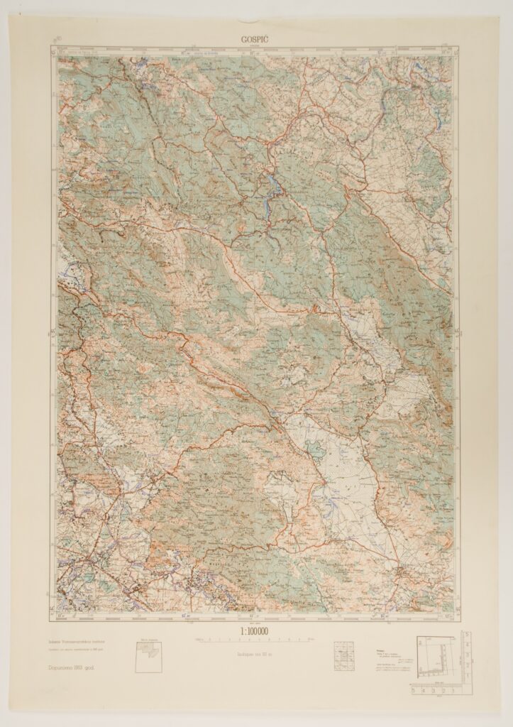
Fifty-one supplemented sheets of topographic maps with depictions of the territory of the Federal People’s Republic of Yugoslavia published in the 1950s and 1960s, based on the revision of the 1930s. In 1920, the Military Geographical Institute began producing and printing the first topographic maps of Croatian territory in 1:100,000 scale. Since the territory of today’s Slovenia, Croatia, Bosnia and Herzegovina, and Vojvodina was part of the Austro-Hungarian Monarchy until the end of World War I in 1918, the topographic maps of the military geographical institute in Vienna in 1:75,000 scale served as the basis for producing new maps, and were amended and supplemented over time. The new maps were printed in four colours: hydrography was marked in blue, relief forms in brown, vegetation in green, and other topographic symbols in black. Along with a comprehensive and detailed overview of Croatian territory, the amended maps corrected many incorrectly written toponyms, which were a common occurrence on special maps published by the Imperial and Royal Military Geographical Institute in Vienna. The topographic map sheets of the Military Geographical Institute published in the 1960s are marked ‘confidential’ on their upper parts, and every sheet has its own inventory number. The sheets published before the 1970s are marked ‘official’, while those published afterwards are marked ‘internal’. Copying the original reproduction maps was strictly prohibited. Majority of the presented sheets of the topographic maps were found in the museum (HPM-88696 – HPM-88735) while some were donated (HPM-88892 – HPM-88897, HPM-88914 – HPM-88916, HPM-88935 – HPM-88936).

Fifty-one supplemented sheets of topographic maps with depictions of the territory of the Federal People’s Republic of Yugoslavia published in the 1950s and 1960s, based on the revision of the 1930s. In 1920, the Military Geographical Institute began producing and printing the first topographic maps of Croatian territory in 1:100,000 scale. Since the territory of today’s Slovenia, Croatia, Bosnia and Herzegovina, and Vojvodina was part of the Austro-Hungarian Monarchy until the end of World War I in 1918, the topographic maps of the military geographical institute in Vienna in 1:75,000 scale served as the basis for producing new maps, and were amended and supplemented over time. The new maps were printed in four colours: hydrography was marked in blue, relief forms in brown, vegetation in green, and other topographic symbols in black. Along with a comprehensive and detailed overview of Croatian territory, the amended maps corrected many incorrectly written toponyms, which were a common occurrence on special maps published by the Imperial and Royal Military Geographical Institute in Vienna. The topographic map sheets of the Military Geographical Institute published in the 1960s are marked ‘confidential’ on their upper parts, and every sheet has its own inventory number. The sheets published before the 1970s are marked ‘official’, while those published afterwards are marked ‘internal’. Copying the original reproduction maps was strictly prohibited. Majority of the presented sheets of the topographic maps were found in the museum (HPM-88696 – HPM-88735) while some were donated (HPM-88892 – HPM-88897, HPM-88914 – HPM-88916, HPM-88935 – HPM-88936).
Fifty-one supplemented sheets of topographic maps with depictions of the territory of the Federal People’s Republic of Yugoslavia published in the 1950s and 1960s, based on the revision of the 1930s. In 1920, the Military Geographical Institute began producing and printing the first topographic maps of Croatian territory in 1:100,000 scale. Since the territory of today’s Slovenia, Croatia, Bosnia and Herzegovina, and Vojvodina was part of the Austro-Hungarian Monarchy until the end of World War I in 1918, the topographic maps of the military geographical institute in Vienna in 1:75,000 scale served as the basis for producing new maps, and were amended and supplemented over time. The new maps were printed in four colours: hydrography was marked in blue, relief forms in brown, vegetation in green, and other topographic symbols in black. Along with a comprehensive and detailed overview of Croatian territory, the amended maps corrected many incorrectly written toponyms, which were a common occurrence on special maps published by the Imperial and Royal Military Geographical Institute in Vienna. The topographic map sheets of the Military Geographical Institute published in the 1960s are marked ‘confidential’ on their upper parts, and every sheet has its own inventory number. The sheets published before the 1970s are marked ‘official’, while those published afterwards are marked ‘internal’. Copying the original reproduction maps was strictly prohibited. Majority of the presented sheets of the topographic maps were found in the museum (HPM-88696 – HPM-88735) while some were donated (HPM-88892 – HPM-88897, HPM-88914 – HPM-88916, HPM-88935 – HPM-88936).
Fifty-one supplemented sheets of topographic maps with depictions of the territory of the Federal People’s Republic of Yugoslavia published in the 1950s and 1960s, based on the revision of the 1930s. In 1920, the Military Geographical Institute began producing and printing the first topographic maps of Croatian territory in 1:100,000 scale. Since the territory of today’s Slovenia, Croatia, Bosnia and Herzegovina, and Vojvodina was part of the Austro-Hungarian Monarchy until the end of World War I in 1918, the topographic maps of the military geographical institute in Vienna in 1:75,000 scale served as the basis for producing new maps, and were amended and supplemented over time. The new maps were printed in four colours: hydrography was marked in blue, relief forms in brown, vegetation in green, and other topographic symbols in black. Along with a comprehensive and detailed overview of Croatian territory, the amended maps corrected many incorrectly written toponyms, which were a common occurrence on special maps published by the Imperial and Royal Military Geographical Institute in Vienna. The topographic map sheets of the Military Geographical Institute published in the 1960s are marked ‘confidential’ on their upper parts, and every sheet has its own inventory number. The sheets published before the 1970s are marked ‘official’, while those published afterwards are marked ‘internal’. Copying the original reproduction maps was strictly prohibited. Majority of the presented sheets of the topographic maps were found in the museum (HPM-88696 – HPM-88735) while some were donated (HPM-88892 – HPM-88897, HPM-88914 – HPM-88916, HPM-88935 – HPM-88936).
Fifty-one supplemented sheets of topographic maps with depictions of the territory of the Federal People’s Republic of Yugoslavia published in the 1950s and 1960s, based on the revision of the 1930s. In 1920, the Military Geographical Institute began producing and printing the first topographic maps of Croatian territory in 1:100,000 scale. Since the territory of today’s Slovenia, Croatia, Bosnia and Herzegovina, and Vojvodina was part of the Austro-Hungarian Monarchy until the end of World War I in 1918, the topographic maps of the military geographical institute in Vienna in 1:75,000 scale served as the basis for producing new maps, and were amended and supplemented over time. The new maps were printed in four colours: hydrography was marked in blue, relief forms in brown, vegetation in green, and other topographic symbols in black. Along with a comprehensive and detailed overview of Croatian territory, the amended maps corrected many incorrectly written toponyms, which were a common occurrence on special maps published by the Imperial and Royal Military Geographical Institute in Vienna. The topographic map sheets of the Military Geographical Institute published in the 1960s are marked ‘confidential’ on their upper parts, and every sheet has its own inventory number. The sheets published before the 1970s are marked ‘official’, while those published afterwards are marked ‘internal’. Copying the original reproduction maps was strictly prohibited. Majority of the presented sheets of the topographic maps were found in the museum (HPM-88696 – HPM-88735) while some were donated (HPM-88892 – HPM-88897, HPM-88914 – HPM-88916, HPM-88935 – HPM-88936).
Fifty-one supplemented sheets of topographic maps with depictions of the territory of the Federal People’s Republic of Yugoslavia published in the 1950s and 1960s, based on the revision of the 1930s. In 1920, the Military Geographical Institute began producing and printing the first topographic maps of Croatian territory in 1:100,000 scale. Since the territory of today’s Slovenia, Croatia, Bosnia and Herzegovina, and Vojvodina was part of the Austro-Hungarian Monarchy until the end of World War I in 1918, the topographic maps of the military geographical institute in Vienna in 1:75,000 scale served as the basis for producing new maps, and were amended and supplemented over time. The new maps were printed in four colours: hydrography was marked in blue, relief forms in brown, vegetation in green, and other topographic symbols in black. Along with a comprehensive and detailed overview of Croatian territory, the amended maps corrected many incorrectly written toponyms, which were a common occurrence on special maps published by the Imperial and Royal Military Geographical Institute in Vienna. The topographic map sheets of the Military Geographical Institute published in the 1960s are marked ‘confidential’ on their upper parts, and every sheet has its own inventory number. The sheets published before the 1970s are marked ‘official’, while those published afterwards are marked ‘internal’. Copying the original reproduction maps was strictly prohibited. Majority of the presented sheets of the topographic maps were found in the museum (HPM-88696 – HPM-88735) while some were donated (HPM-88892 – HPM-88897, HPM-88914 – HPM-88916, HPM-88935 – HPM-88936).
Fifty-one supplemented sheets of topographic maps with depictions of the territory of the Federal People’s Republic of Yugoslavia published in the 1950s and 1960s, based on the revision of the 1930s. In 1920, the Military Geographical Institute began producing and printing the first topographic maps of Croatian territory in 1:100,000 scale. Since the territory of today’s Slovenia, Croatia, Bosnia and Herzegovina, and Vojvodina was part of the Austro-Hungarian Monarchy until the end of World War I in 1918, the topographic maps of the military geographical institute in Vienna in 1:75,000 scale served as the basis for producing new maps, and were amended and supplemented over time. The new maps were printed in four colours: hydrography was marked in blue, relief forms in brown, vegetation in green, and other topographic symbols in black. Along with a comprehensive and detailed overview of Croatian territory, the amended maps corrected many incorrectly written toponyms, which were a common occurrence on special maps published by the Imperial and Royal Military Geographical Institute in Vienna. The topographic map sheets of the Military Geographical Institute published in the 1960s are marked ‘confidential’ on their upper parts, and every sheet has its own inventory number. The sheets published before the 1970s are marked ‘official’, while those published afterwards are marked ‘internal’. Copying the original reproduction maps was strictly prohibited. Majority of the presented sheets of the topographic maps were found in the museum (HPM-88696 – HPM-88735) while some were donated (HPM-88892 – HPM-88897, HPM-88914 – HPM-88916, HPM-88935 – HPM-88936).
Fifty-one supplemented sheets of topographic maps with depictions of the territory of the Federal People’s Republic of Yugoslavia published in the 1950s and 1960s, based on the revision of the 1930s. In 1920, the Military Geographical Institute began producing and printing the first topographic maps of Croatian territory in 1:100,000 scale. Since the territory of today’s Slovenia, Croatia, Bosnia and Herzegovina, and Vojvodina was part of the Austro-Hungarian Monarchy until the end of World War I in 1918, the topographic maps of the military geographical institute in Vienna in 1:75,000 scale served as the basis for producing new maps, and were amended and supplemented over time. The new maps were printed in four colours: hydrography was marked in blue, relief forms in brown, vegetation in green, and other topographic symbols in black. Along with a comprehensive and detailed overview of Croatian territory, the amended maps corrected many incorrectly written toponyms, which were a common occurrence on special maps published by the Imperial and Royal Military Geographical Institute in Vienna. The topographic map sheets of the Military Geographical Institute published in the 1960s are marked ‘confidential’ on their upper parts, and every sheet has its own inventory number. The sheets published before the 1970s are marked ‘official’, while those published afterwards are marked ‘internal’. Copying the original reproduction maps was strictly prohibited. Majority of the presented sheets of the topographic maps were found in the museum (HPM-88696 – HPM-88735) while some were donated (HPM-88892 – HPM-88897, HPM-88914 – HPM-88916, HPM-88935 – HPM-88936).
Fifty-one supplemented sheets of topographic maps with depictions of the territory of the Federal People’s Republic of Yugoslavia published in the 1950s and 1960s, based on the revision of the 1930s. In 1920, the Military Geographical Institute began producing and printing the first topographic maps of Croatian territory in 1:100,000 scale. Since the territory of today’s Slovenia, Croatia, Bosnia and Herzegovina, and Vojvodina was part of the Austro-Hungarian Monarchy until the end of World War I in 1918, the topographic maps of the military geographical institute in Vienna in 1:75,000 scale served as the basis for producing new maps, and were amended and supplemented over time. The new maps were printed in four colours: hydrography was marked in blue, relief forms in brown, vegetation in green, and other topographic symbols in black. Along with a comprehensive and detailed overview of Croatian territory, the amended maps corrected many incorrectly written toponyms, which were a common occurrence on special maps published by the Imperial and Royal Military Geographical Institute in Vienna. The topographic map sheets of the Military Geographical Institute published in the 1960s are marked ‘confidential’ on their upper parts, and every sheet has its own inventory number. The sheets published before the 1970s are marked ‘official’, while those published afterwards are marked ‘internal’. Copying the original reproduction maps was strictly prohibited. Majority of the presented sheets of the topographic maps were found in the museum (HPM-88696 – HPM-88735) while some were donated (HPM-88892 – HPM-88897, HPM-88914 – HPM-88916, HPM-88935 – HPM-88936).
Fifty-one supplemented sheets of topographic maps with depictions of the territory of the Federal People’s Republic of Yugoslavia published in the 1950s and 1960s, based on the revision of the 1930s. In 1920, the Military Geographical Institute began producing and printing the first topographic maps of Croatian territory in 1:100,000 scale. Since the territory of today’s Slovenia, Croatia, Bosnia and Herzegovina, and Vojvodina was part of the Austro-Hungarian Monarchy until the end of World War I in 1918, the topographic maps of the military geographical institute in Vienna in 1:75,000 scale served as the basis for producing new maps, and were amended and supplemented over time. The new maps were printed in four colours: hydrography was marked in blue, relief forms in brown, vegetation in green, and other topographic symbols in black. Along with a comprehensive and detailed overview of Croatian territory, the amended maps corrected many incorrectly written toponyms, which were a common occurrence on special maps published by the Imperial and Royal Military Geographical Institute in Vienna. The topographic map sheets of the Military Geographical Institute published in the 1960s are marked ‘confidential’ on their upper parts, and every sheet has its own inventory number. The sheets published before the 1970s are marked ‘official’, while those published afterwards are marked ‘internal’. Copying the original reproduction maps was strictly prohibited. Majority of the presented sheets of the topographic maps were found in the museum (HPM-88696 – HPM-88735) while some were donated (HPM-88892 – HPM-88897, HPM-88914 – HPM-88916, HPM-88935 – HPM-88936).
Fifty-one supplemented sheets of topographic maps with depictions of the territory of the Federal People’s Republic of Yugoslavia published in the 1950s and 1960s, based on the revision of the 1930s. In 1920, the Military Geographical Institute began producing and printing the first topographic maps of Croatian territory in 1:100,000 scale. Since the territory of today’s Slovenia, Croatia, Bosnia and Herzegovina, and Vojvodina was part of the Austro-Hungarian Monarchy until the end of World War I in 1918, the topographic maps of the military geographical institute in Vienna in 1:75,000 scale served as the basis for producing new maps, and were amended and supplemented over time. The new maps were printed in four colours: hydrography was marked in blue, relief forms in brown, vegetation in green, and other topographic symbols in black. Along with a comprehensive and detailed overview of Croatian territory, the amended maps corrected many incorrectly written toponyms, which were a common occurrence on special maps published by the Imperial and Royal Military Geographical Institute in Vienna. The topographic map sheets of the Military Geographical Institute published in the 1960s are marked ‘confidential’ on their upper parts, and every sheet has its own inventory number. The sheets published before the 1970s are marked ‘official’, while those published afterwards are marked ‘internal’. Copying the original reproduction maps was strictly prohibited. Majority of the presented sheets of the topographic maps were found in the museum (HPM-88696 – HPM-88735) while some were donated (HPM-88892 – HPM-88897, HPM-88914 – HPM-88916, HPM-88935 – HPM-88936).
Fifty-one supplemented sheets of topographic maps with depictions of the territory of the Federal People’s Republic of Yugoslavia published in the 1950s and 1960s, based on the revision of the 1930s. In 1920, the Military Geographical Institute began producing and printing the first topographic maps of Croatian territory in 1:100,000 scale. Since the territory of today’s Slovenia, Croatia, Bosnia and Herzegovina, and Vojvodina was part of the Austro-Hungarian Monarchy until the end of World War I in 1918, the topographic maps of the military geographical institute in Vienna in 1:75,000 scale served as the basis for producing new maps, and were amended and supplemented over time. The new maps were printed in four colours: hydrography was marked in blue, relief forms in brown, vegetation in green, and other topographic symbols in black. Along with a comprehensive and detailed overview of Croatian territory, the amended maps corrected many incorrectly written toponyms, which were a common occurrence on special maps published by the Imperial and Royal Military Geographical Institute in Vienna. The topographic map sheets of the Military Geographical Institute published in the 1960s are marked ‘confidential’ on their upper parts, and every sheet has its own inventory number. The sheets published before the 1970s are marked ‘official’, while those published afterwards are marked ‘internal’. Copying the original reproduction maps was strictly prohibited. Majority of the presented sheets of the topographic maps were found in the museum (HPM-88696 – HPM-88735) while some were donated (HPM-88892 – HPM-88897, HPM-88914 – HPM-88916, HPM-88935 – HPM-88936).
Fifty-one supplemented sheets of topographic maps with depictions of the territory of the Federal People’s Republic of Yugoslavia published in the 1950s and 1960s, based on the revision of the 1930s. In 1920, the Military Geographical Institute began producing and printing the first topographic maps of Croatian territory in 1:100,000 scale. Since the territory of today’s Slovenia, Croatia, Bosnia and Herzegovina, and Vojvodina was part of the Austro-Hungarian Monarchy until the end of World War I in 1918, the topographic maps of the military geographical institute in Vienna in 1:75,000 scale served as the basis for producing new maps, and were amended and supplemented over time. The new maps were printed in four colours: hydrography was marked in blue, relief forms in brown, vegetation in green, and other topographic symbols in black. Along with a comprehensive and detailed overview of Croatian territory, the amended maps corrected many incorrectly written toponyms, which were a common occurrence on special maps published by the Imperial and Royal Military Geographical Institute in Vienna. The topographic map sheets of the Military Geographical Institute published in the 1960s are marked ‘confidential’ on their upper parts, and every sheet has its own inventory number. The sheets published before the 1970s are marked ‘official’, while those published afterwards are marked ‘internal’. Copying the original reproduction maps was strictly prohibited. Majority of the presented sheets of the topographic maps were found in the museum (HPM-88696 – HPM-88735) while some were donated (HPM-88892 – HPM-88897, HPM-88914 – HPM-88916, HPM-88935 – HPM-88936).
Fifty-one supplemented sheets of topographic maps with depictions of the territory of the Federal People’s Republic of Yugoslavia published in the 1950s and 1960s, based on the revision of the 1930s. In 1920, the Military Geographical Institute began producing and printing the first topographic maps of Croatian territory in 1:100,000 scale. Since the territory of today’s Slovenia, Croatia, Bosnia and Herzegovina, and Vojvodina was part of the Austro-Hungarian Monarchy until the end of World War I in 1918, the topographic maps of the military geographical institute in Vienna in 1:75,000 scale served as the basis for producing new maps, and were amended and supplemented over time. The new maps were printed in four colours: hydrography was marked in blue, relief forms in brown, vegetation in green, and other topographic symbols in black. Along with a comprehensive and detailed overview of Croatian territory, the amended maps corrected many incorrectly written toponyms, which were a common occurrence on special maps published by the Imperial and Royal Military Geographical Institute in Vienna. The topographic map sheets of the Military Geographical Institute published in the 1960s are marked ‘confidential’ on their upper parts, and every sheet has its own inventory number. The sheets published before the 1970s are marked ‘official’, while those published afterwards are marked ‘internal’. Copying the original reproduction maps was strictly prohibited. Majority of the presented sheets of the topographic maps were found in the museum (HPM-88696 – HPM-88735) while some were donated (HPM-88892 – HPM-88897, HPM-88914 – HPM-88916, HPM-88935 – HPM-88936).
Fifty-one supplemented sheets of topographic maps with depictions of the territory of the Federal People’s Republic of Yugoslavia published in the 1950s and 1960s, based on the revision of the 1930s. In 1920, the Military Geographical Institute began producing and printing the first topographic maps of Croatian territory in 1:100,000 scale. Since the territory of today’s Slovenia, Croatia, Bosnia and Herzegovina, and Vojvodina was part of the Austro-Hungarian Monarchy until the end of World War I in 1918, the topographic maps of the military geographical institute in Vienna in 1:75,000 scale served as the basis for producing new maps, and were amended and supplemented over time. The new maps were printed in four colours: hydrography was marked in blue, relief forms in brown, vegetation in green, and other topographic symbols in black. Along with a comprehensive and detailed overview of Croatian territory, the amended maps corrected many incorrectly written toponyms, which were a common occurrence on special maps published by the Imperial and Royal Military Geographical Institute in Vienna. The topographic map sheets of the Military Geographical Institute published in the 1960s are marked ‘confidential’ on their upper parts, and every sheet has its own inventory number. The sheets published before the 1970s are marked ‘official’, while those published afterwards are marked ‘internal’. Copying the original reproduction maps was strictly prohibited. Majority of the presented sheets of the topographic maps were found in the museum (HPM-88696 – HPM-88735) while some were donated (HPM-88892 – HPM-88897, HPM-88914 – HPM-88916, HPM-88935 – HPM-88936).
Fifty-one supplemented sheets of topographic maps with depictions of the territory of the Federal People’s Republic of Yugoslavia published in the 1950s and 1960s, based on the revision of the 1930s. In 1920, the Military Geographical Institute began producing and printing the first topographic maps of Croatian territory in 1:100,000 scale. Since the territory of today’s Slovenia, Croatia, Bosnia and Herzegovina, and Vojvodina was part of the Austro-Hungarian Monarchy until the end of World War I in 1918, the topographic maps of the military geographical institute in Vienna in 1:75,000 scale served as the basis for producing new maps, and were amended and supplemented over time. The new maps were printed in four colours: hydrography was marked in blue, relief forms in brown, vegetation in green, and other topographic symbols in black. Along with a comprehensive and detailed overview of Croatian territory, the amended maps corrected many incorrectly written toponyms, which were a common occurrence on special maps published by the Imperial and Royal Military Geographical Institute in Vienna. The topographic map sheets of the Military Geographical Institute published in the 1960s are marked ‘confidential’ on their upper parts, and every sheet has its own inventory number. The sheets published before the 1970s are marked ‘official’, while those published afterwards are marked ‘internal’. Copying the original reproduction maps was strictly prohibited. Majority of the presented sheets of the topographic maps were found in the museum (HPM-88696 – HPM-88735) while some were donated (HPM-88892 – HPM-88897, HPM-88914 – HPM-88916, HPM-88935 – HPM-88936).
Fifty-one supplemented sheets of topographic maps with depictions of the territory of the Federal People’s Republic of Yugoslavia published in the 1950s and 1960s, based on the revision of the 1930s. In 1920, the Military Geographical Institute began producing and printing the first topographic maps of Croatian territory in 1:100,000 scale. Since the territory of today’s Slovenia, Croatia, Bosnia and Herzegovina, and Vojvodina was part of the Austro-Hungarian Monarchy until the end of World War I in 1918, the topographic maps of the military geographical institute in Vienna in 1:75,000 scale served as the basis for producing new maps, and were amended and supplemented over time. The new maps were printed in four colours: hydrography was marked in blue, relief forms in brown, vegetation in green, and other topographic symbols in black. Along with a comprehensive and detailed overview of Croatian territory, the amended maps corrected many incorrectly written toponyms, which were a common occurrence on special maps published by the Imperial and Royal Military Geographical Institute in Vienna. The topographic map sheets of the Military Geographical Institute published in the 1960s are marked ‘confidential’ on their upper parts, and every sheet has its own inventory number. The sheets published before the 1970s are marked ‘official’, while those published afterwards are marked ‘internal’. Copying the original reproduction maps was strictly prohibited. Majority of the presented sheets of the topographic maps were found in the museum (HPM-88696 – HPM-88735) while some were donated (HPM-88892 – HPM-88897, HPM-88914 – HPM-88916, HPM-88935 – HPM-88936).
Fifty-one supplemented sheets of topographic maps with depictions of the territory of the Federal People’s Republic of Yugoslavia published in the 1950s and 1960s, based on the revision of the 1930s. In 1920, the Military Geographical Institute began producing and printing the first topographic maps of Croatian territory in 1:100,000 scale. Since the territory of today’s Slovenia, Croatia, Bosnia and Herzegovina, and Vojvodina was part of the Austro-Hungarian Monarchy until the end of World War I in 1918, the topographic maps of the military geographical institute in Vienna in 1:75,000 scale served as the basis for producing new maps, and were amended and supplemented over time. The new maps were printed in four colours: hydrography was marked in blue, relief forms in brown, vegetation in green, and other topographic symbols in black. Along with a comprehensive and detailed overview of Croatian territory, the amended maps corrected many incorrectly written toponyms, which were a common occurrence on special maps published by the Imperial and Royal Military Geographical Institute in Vienna. The topographic map sheets of the Military Geographical Institute published in the 1960s are marked ‘confidential’ on their upper parts, and every sheet has its own inventory number. The sheets published before the 1970s are marked ‘official’, while those published afterwards are marked ‘internal’. Copying the original reproduction maps was strictly prohibited. Majority of the presented sheets of the topographic maps were found in the museum (HPM-88696 – HPM-88735) while some were donated (HPM-88892 – HPM-88897, HPM-88914 – HPM-88916, HPM-88935 – HPM-88936).
Fifty-one supplemented sheets of topographic maps with depictions of the territory of the Federal People’s Republic of Yugoslavia published in the 1950s and 1960s, based on the revision of the 1930s. In 1920, the Military Geographical Institute began producing and printing the first topographic maps of Croatian territory in 1:100,000 scale. Since the territory of today’s Slovenia, Croatia, Bosnia and Herzegovina, and Vojvodina was part of the Austro-Hungarian Monarchy until the end of World War I in 1918, the topographic maps of the military geographical institute in Vienna in 1:75,000 scale served as the basis for producing new maps, and were amended and supplemented over time. The new maps were printed in four colours: hydrography was marked in blue, relief forms in brown, vegetation in green, and other topographic symbols in black. Along with a comprehensive and detailed overview of Croatian territory, the amended maps corrected many incorrectly written toponyms, which were a common occurrence on special maps published by the Imperial and Royal Military Geographical Institute in Vienna. The topographic map sheets of the Military Geographical Institute published in the 1960s are marked ‘confidential’ on their upper parts, and every sheet has its own inventory number. The sheets published before the 1970s are marked ‘official’, while those published afterwards are marked ‘internal’. Copying the original reproduction maps was strictly prohibited. Majority of the presented sheets of the topographic maps were found in the museum (HPM-88696 – HPM-88735) while some were donated (HPM-88892 – HPM-88897, HPM-88914 – HPM-88916, HPM-88935 – HPM-88936).
Fifty-one supplemented sheets of topographic maps with depictions of the territory of the Federal People’s Republic of Yugoslavia published in the 1950s and 1960s, based on the revision of the 1930s. In 1920, the Military Geographical Institute began producing and printing the first topographic maps of Croatian territory in 1:100,000 scale. Since the territory of today’s Slovenia, Croatia, Bosnia and Herzegovina, and Vojvodina was part of the Austro-Hungarian Monarchy until the end of World War I in 1918, the topographic maps of the military geographical institute in Vienna in 1:75,000 scale served as the basis for producing new maps, and were amended and supplemented over time. The new maps were printed in four colours: hydrography was marked in blue, relief forms in brown, vegetation in green, and other topographic symbols in black. Along with a comprehensive and detailed overview of Croatian territory, the amended maps corrected many incorrectly written toponyms, which were a common occurrence on special maps published by the Imperial and Royal Military Geographical Institute in Vienna. The topographic map sheets of the Military Geographical Institute published in the 1960s are marked ‘confidential’ on their upper parts, and every sheet has its own inventory number. The sheets published before the 1970s are marked ‘official’, while those published afterwards are marked ‘internal’. Copying the original reproduction maps was strictly prohibited. Majority of the presented sheets of the topographic maps were found in the museum (HPM-88696 – HPM-88735) while some were donated (HPM-88892 – HPM-88897, HPM-88914 – HPM-88916, HPM-88935 – HPM-88936).
Fifty-one supplemented sheets of topographic maps with depictions of the territory of the Federal People’s Republic of Yugoslavia published in the 1950s and 1960s, based on the revision of the 1930s. In 1920, the Military Geographical Institute began producing and printing the first topographic maps of Croatian territory in 1:100,000 scale. Since the territory of today’s Slovenia, Croatia, Bosnia and Herzegovina, and Vojvodina was part of the Austro-Hungarian Monarchy until the end of World War I in 1918, the topographic maps of the military geographical institute in Vienna in 1:75,000 scale served as the basis for producing new maps, and were amended and supplemented over time. The new maps were printed in four colours: hydrography was marked in blue, relief forms in brown, vegetation in green, and other topographic symbols in black. Along with a comprehensive and detailed overview of Croatian territory, the amended maps corrected many incorrectly written toponyms, which were a common occurrence on special maps published by the Imperial and Royal Military Geographical Institute in Vienna. The topographic map sheets of the Military Geographical Institute published in the 1960s are marked ‘confidential’ on their upper parts, and every sheet has its own inventory number. The sheets published before the 1970s are marked ‘official’, while those published afterwards are marked ‘internal’. Copying the original reproduction maps was strictly prohibited. Majority of the presented sheets of the topographic maps were found in the museum (HPM-88696 – HPM-88735) while some were donated (HPM-88892 – HPM-88897, HPM-88914 – HPM-88916, HPM-88935 – HPM-88936).
Fifty-one supplemented sheets of topographic maps with depictions of the territory of the Federal People’s Republic of Yugoslavia published in the 1950s and 1960s, based on the revision of the 1930s. In 1920, the Military Geographical Institute began producing and printing the first topographic maps of Croatian territory in 1:100,000 scale. Since the territory of today’s Slovenia, Croatia, Bosnia and Herzegovina, and Vojvodina was part of the Austro-Hungarian Monarchy until the end of World War I in 1918, the topographic maps of the military geographical institute in Vienna in 1:75,000 scale served as the basis for producing new maps, and were amended and supplemented over time. The new maps were printed in four colours: hydrography was marked in blue, relief forms in brown, vegetation in green, and other topographic symbols in black. Along with a comprehensive and detailed overview of Croatian territory, the amended maps corrected many incorrectly written toponyms, which were a common occurrence on special maps published by the Imperial and Royal Military Geographical Institute in Vienna. The topographic map sheets of the Military Geographical Institute published in the 1960s are marked ‘confidential’ on their upper parts, and every sheet has its own inventory number. The sheets published before the 1970s are marked ‘official’, while those published afterwards are marked ‘internal’. Copying the original reproduction maps was strictly prohibited. Majority of the presented sheets of the topographic maps were found in the museum (HPM-88696 – HPM-88735) while some were donated (HPM-88892 – HPM-88897, HPM-88914 – HPM-88916, HPM-88935 – HPM-88936).
Fifty-one supplemented sheets of topographic maps with depictions of the territory of the Federal People’s Republic of Yugoslavia published in the 1950s and 1960s, based on the revision of the 1930s. In 1920, the Military Geographical Institute began producing and printing the first topographic maps of Croatian territory in 1:100,000 scale. Since the territory of today’s Slovenia, Croatia, Bosnia and Herzegovina, and Vojvodina was part of the Austro-Hungarian Monarchy until the end of World War I in 1918, the topographic maps of the military geographical institute in Vienna in 1:75,000 scale served as the basis for producing new maps, and were amended and supplemented over time. The new maps were printed in four colours: hydrography was marked in blue, relief forms in brown, vegetation in green, and other topographic symbols in black. Along with a comprehensive and detailed overview of Croatian territory, the amended maps corrected many incorrectly written toponyms, which were a common occurrence on special maps published by the Imperial and Royal Military Geographical Institute in Vienna. The topographic map sheets of the Military Geographical Institute published in the 1960s are marked ‘confidential’ on their upper parts, and every sheet has its own inventory number. The sheets published before the 1970s are marked ‘official’, while those published afterwards are marked ‘internal’. Copying the original reproduction maps was strictly prohibited. Majority of the presented sheets of the topographic maps were found in the museum (HPM-88696 – HPM-88735) while some were donated (HPM-88892 – HPM-88897, HPM-88914 – HPM-88916, HPM-88935 – HPM-88936).
Fifty-one supplemented sheets of topographic maps with depictions of the territory of the Federal People’s Republic of Yugoslavia published in the 1950s and 1960s, based on the revision of the 1930s. In 1920, the Military Geographical Institute began producing and printing the first topographic maps of Croatian territory in 1:100,000 scale. Since the territory of today’s Slovenia, Croatia, Bosnia and Herzegovina, and Vojvodina was part of the Austro-Hungarian Monarchy until the end of World War I in 1918, the topographic maps of the military geographical institute in Vienna in 1:75,000 scale served as the basis for producing new maps, and were amended and supplemented over time. The new maps were printed in four colours: hydrography was marked in blue, relief forms in brown, vegetation in green, and other topographic symbols in black. Along with a comprehensive and detailed overview of Croatian territory, the amended maps corrected many incorrectly written toponyms, which were a common occurrence on special maps published by the Imperial and Royal Military Geographical Institute in Vienna. The topographic map sheets of the Military Geographical Institute published in the 1960s are marked ‘confidential’ on their upper parts, and every sheet has its own inventory number. The sheets published before the 1970s are marked ‘official’, while those published afterwards are marked ‘internal’. Copying the original reproduction maps was strictly prohibited. Majority of the presented sheets of the topographic maps were found in the museum (HPM-88696 – HPM-88735) while some were donated (HPM-88892 – HPM-88897, HPM-88914 – HPM-88916, HPM-88935 – HPM-88936).
Fifty-one supplemented sheets of topographic maps with depictions of the territory of the Federal People’s Republic of Yugoslavia published in the 1950s and 1960s, based on the revision of the 1930s. In 1920, the Military Geographical Institute began producing and printing the first topographic maps of Croatian territory in 1:100,000 scale. Since the territory of today’s Slovenia, Croatia, Bosnia and Herzegovina, and Vojvodina was part of the Austro-Hungarian Monarchy until the end of World War I in 1918, the topographic maps of the military geographical institute in Vienna in 1:75,000 scale served as the basis for producing new maps, and were amended and supplemented over time. The new maps were printed in four colours: hydrography was marked in blue, relief forms in brown, vegetation in green, and other topographic symbols in black. Along with a comprehensive and detailed overview of Croatian territory, the amended maps corrected many incorrectly written toponyms, which were a common occurrence on special maps published by the Imperial and Royal Military Geographical Institute in Vienna. The topographic map sheets of the Military Geographical Institute published in the 1960s are marked ‘confidential’ on their upper parts, and every sheet has its own inventory number. The sheets published before the 1970s are marked ‘official’, while those published afterwards are marked ‘internal’. Copying the original reproduction maps was strictly prohibited. Majority of the presented sheets of the topographic maps were found in the museum (HPM-88696 – HPM-88735) while some were donated (HPM-88892 – HPM-88897, HPM-88914 – HPM-88916, HPM-88935 – HPM-88936).
Fifty-one supplemented sheets of topographic maps with depictions of the territory of the Federal People’s Republic of Yugoslavia published in the 1950s and 1960s, based on the revision of the 1930s. In 1920, the Military Geographical Institute began producing and printing the first topographic maps of Croatian territory in 1:100,000 scale. Since the territory of today’s Slovenia, Croatia, Bosnia and Herzegovina, and Vojvodina was part of the Austro-Hungarian Monarchy until the end of World War I in 1918, the topographic maps of the military geographical institute in Vienna in 1:75,000 scale served as the basis for producing new maps, and were amended and supplemented over time. The new maps were printed in four colours: hydrography was marked in blue, relief forms in brown, vegetation in green, and other topographic symbols in black. Along with a comprehensive and detailed overview of Croatian territory, the amended maps corrected many incorrectly written toponyms, which were a common occurrence on special maps published by the Imperial and Royal Military Geographical Institute in Vienna. The topographic map sheets of the Military Geographical Institute published in the 1960s are marked ‘confidential’ on their upper parts, and every sheet has its own inventory number. The sheets published before the 1970s are marked ‘official’, while those published afterwards are marked ‘internal’. Copying the original reproduction maps was strictly prohibited. Majority of the presented sheets of the topographic maps were found in the museum (HPM-88696 – HPM-88735) while some were donated (HPM-88892 – HPM-88897, HPM-88914 – HPM-88916, HPM-88935 – HPM-88936).
Fifty-one supplemented sheets of topographic maps with depictions of the territory of the Federal People’s Republic of Yugoslavia published in the 1950s and 1960s, based on the revision of the 1930s. In 1920, the Military Geographical Institute began producing and printing the first topographic maps of Croatian territory in 1:100,000 scale. Since the territory of today’s Slovenia, Croatia, Bosnia and Herzegovina, and Vojvodina was part of the Austro-Hungarian Monarchy until the end of World War I in 1918, the topographic maps of the military geographical institute in Vienna in 1:75,000 scale served as the basis for producing new maps, and were amended and supplemented over time. The new maps were printed in four colours: hydrography was marked in blue, relief forms in brown, vegetation in green, and other topographic symbols in black. Along with a comprehensive and detailed overview of Croatian territory, the amended maps corrected many incorrectly written toponyms, which were a common occurrence on special maps published by the Imperial and Royal Military Geographical Institute in Vienna. The topographic map sheets of the Military Geographical Institute published in the 1960s are marked ‘confidential’ on their upper parts, and every sheet has its own inventory number. The sheets published before the 1970s are marked ‘official’, while those published afterwards are marked ‘internal’. Copying the original reproduction maps was strictly prohibited. Majority of the presented sheets of the topographic maps were found in the museum (HPM-88696 – HPM-88735) while some were donated (HPM-88892 – HPM-88897, HPM-88914 – HPM-88916, HPM-88935 – HPM-88936).
Fifty-one supplemented sheets of topographic maps with depictions of the territory of the Federal People’s Republic of Yugoslavia published in the 1950s and 1960s, based on the revision of the 1930s. In 1920, the Military Geographical Institute began producing and printing the first topographic maps of Croatian territory in 1:100,000 scale. Since the territory of today’s Slovenia, Croatia, Bosnia and Herzegovina, and Vojvodina was part of the Austro-Hungarian Monarchy until the end of World War I in 1918, the topographic maps of the military geographical institute in Vienna in 1:75,000 scale served as the basis for producing new maps, and were amended and supplemented over time. The new maps were printed in four colours: hydrography was marked in blue, relief forms in brown, vegetation in green, and other topographic symbols in black. Along with a comprehensive and detailed overview of Croatian territory, the amended maps corrected many incorrectly written toponyms, which were a common occurrence on special maps published by the Imperial and Royal Military Geographical Institute in Vienna. The topographic map sheets of the Military Geographical Institute published in the 1960s are marked ‘confidential’ on their upper parts, and every sheet has its own inventory number. The sheets published before the 1970s are marked ‘official’, while those published afterwards are marked ‘internal’. Copying the original reproduction maps was strictly prohibited. Majority of the presented sheets of the topographic maps were found in the museum (HPM-88696 – HPM-88735) while some were donated (HPM-88892 – HPM-88897, HPM-88914 – HPM-88916, HPM-88935 – HPM-88936).
Fifty-one supplemented sheets of topographic maps with depictions of the territory of the Federal People’s Republic of Yugoslavia published in the 1950s and 1960s, based on the revision of the 1930s. In 1920, the Military Geographical Institute began producing and printing the first topographic maps of Croatian territory in 1:100,000 scale. Since the territory of today’s Slovenia, Croatia, Bosnia and Herzegovina, and Vojvodina was part of the Austro-Hungarian Monarchy until the end of World War I in 1918, the topographic maps of the military geographical institute in Vienna in 1:75,000 scale served as the basis for producing new maps, and were amended and supplemented over time. The new maps were printed in four colours: hydrography was marked in blue, relief forms in brown, vegetation in green, and other topographic symbols in black. Along with a comprehensive and detailed overview of Croatian territory, the amended maps corrected many incorrectly written toponyms, which were a common occurrence on special maps published by the Imperial and Royal Military Geographical Institute in Vienna. The topographic map sheets of the Military Geographical Institute published in the 1960s are marked ‘confidential’ on their upper parts, and every sheet has its own inventory number. The sheets published before the 1970s are marked ‘official’, while those published afterwards are marked ‘internal’. Copying the original reproduction maps was strictly prohibited. Majority of the presented sheets of the topographic maps were found in the museum (HPM-88696 – HPM-88735) while some were donated (HPM-88892 – HPM-88897, HPM-88914 – HPM-88916, HPM-88935 – HPM-88936).
Fifty-one supplemented sheets of topographic maps with depictions of the territory of the Federal People’s Republic of Yugoslavia published in the 1950s and 1960s, based on the revision of the 1930s. In 1920, the Military Geographical Institute began producing and printing the first topographic maps of Croatian territory in 1:100,000 scale. Since the territory of today’s Slovenia, Croatia, Bosnia and Herzegovina, and Vojvodina was part of the Austro-Hungarian Monarchy until the end of World War I in 1918, the topographic maps of the military geographical institute in Vienna in 1:75,000 scale served as the basis for producing new maps, and were amended and supplemented over time. The new maps were printed in four colours: hydrography was marked in blue, relief forms in brown, vegetation in green, and other topographic symbols in black. Along with a comprehensive and detailed overview of Croatian territory, the amended maps corrected many incorrectly written toponyms, which were a common occurrence on special maps published by the Imperial and Royal Military Geographical Institute in Vienna. The topographic map sheets of the Military Geographical Institute published in the 1960s are marked ‘confidential’ on their upper parts, and every sheet has its own inventory number. The sheets published before the 1970s are marked ‘official’, while those published afterwards are marked ‘internal’. Copying the original reproduction maps was strictly prohibited. Majority of the presented sheets of the topographic maps were found in the museum (HPM-88696 – HPM-88735) while some were donated (HPM-88892 – HPM-88897, HPM-88914 – HPM-88916, HPM-88935 – HPM-88936).
Fifty-one supplemented sheets of topographic maps with depictions of the territory of the Federal People’s Republic of Yugoslavia published in the 1950s and 1960s, based on the revision of the 1930s. In 1920, the Military Geographical Institute began producing and printing the first topographic maps of Croatian territory in 1:100,000 scale. Since the territory of today’s Slovenia, Croatia, Bosnia and Herzegovina, and Vojvodina was part of the Austro-Hungarian Monarchy until the end of World War I in 1918, the topographic maps of the military geographical institute in Vienna in 1:75,000 scale served as the basis for producing new maps, and were amended and supplemented over time. The new maps were printed in four colours: hydrography was marked in blue, relief forms in brown, vegetation in green, and other topographic symbols in black. Along with a comprehensive and detailed overview of Croatian territory, the amended maps corrected many incorrectly written toponyms, which were a common occurrence on special maps published by the Imperial and Royal Military Geographical Institute in Vienna. The topographic map sheets of the Military Geographical Institute published in the 1960s are marked ‘confidential’ on their upper parts, and every sheet has its own inventory number. The sheets published before the 1970s are marked ‘official’, while those published afterwards are marked ‘internal’. Copying the original reproduction maps was strictly prohibited. Majority of the presented sheets of the topographic maps were found in the museum (HPM-88696 – HPM-88735) while some were donated (HPM-88892 – HPM-88897, HPM-88914 – HPM-88916, HPM-88935 – HPM-88936).
Fifty-one supplemented sheets of topographic maps with depictions of the territory of the Federal People’s Republic of Yugoslavia published in the 1950s and 1960s, based on the revision of the 1930s. In 1920, the Military Geographical Institute began producing and printing the first topographic maps of Croatian territory in 1:100,000 scale. Since the territory of today’s Slovenia, Croatia, Bosnia and Herzegovina, and Vojvodina was part of the Austro-Hungarian Monarchy until the end of World War I in 1918, the topographic maps of the military geographical institute in Vienna in 1:75,000 scale served as the basis for producing new maps, and were amended and supplemented over time. The new maps were printed in four colours: hydrography was marked in blue, relief forms in brown, vegetation in green, and other topographic symbols in black. Along with a comprehensive and detailed overview of Croatian territory, the amended maps corrected many incorrectly written toponyms, which were a common occurrence on special maps published by the Imperial and Royal Military Geographical Institute in Vienna. The topographic map sheets of the Military Geographical Institute published in the 1960s are marked ‘confidential’ on their upper parts, and every sheet has its own inventory number. The sheets published before the 1970s are marked ‘official’, while those published afterwards are marked ‘internal’. Copying the original reproduction maps was strictly prohibited. Majority of the presented sheets of the topographic maps were found in the museum (HPM-88696 – HPM-88735) while some were donated (HPM-88892 – HPM-88897, HPM-88914 – HPM-88916, HPM-88935 – HPM-88936).
Fifty-one supplemented sheets of topographic maps with depictions of the territory of the Federal People’s Republic of Yugoslavia published in the 1950s and 1960s, based on the revision of the 1930s. In 1920, the Military Geographical Institute began producing and printing the first topographic maps of Croatian territory in 1:100,000 scale. Since the territory of today’s Slovenia, Croatia, Bosnia and Herzegovina, and Vojvodina was part of the Austro-Hungarian Monarchy until the end of World War I in 1918, the topographic maps of the military geographical institute in Vienna in 1:75,000 scale served as the basis for producing new maps, and were amended and supplemented over time. The new maps were printed in four colours: hydrography was marked in blue, relief forms in brown, vegetation in green, and other topographic symbols in black. Along with a comprehensive and detailed overview of Croatian territory, the amended maps corrected many incorrectly written toponyms, which were a common occurrence on special maps published by the Imperial and Royal Military Geographical Institute in Vienna. The topographic map sheets of the Military Geographical Institute published in the 1960s are marked ‘confidential’ on their upper parts, and every sheet has its own inventory number. The sheets published before the 1970s are marked ‘official’, while those published afterwards are marked ‘internal’. Copying the original reproduction maps was strictly prohibited. Majority of the presented sheets of the topographic maps were found in the museum (HPM-88696 – HPM-88735) while some were donated (HPM-88892 – HPM-88897, HPM-88914 – HPM-88916, HPM-88935 – HPM-88936).
Fifty-one supplemented sheets of topographic maps with depictions of the territory of the Federal People’s Republic of Yugoslavia published in the 1950s and 1960s, based on the revision of the 1930s. In 1920, the Military Geographical Institute began producing and printing the first topographic maps of Croatian territory in 1:100,000 scale. Since the territory of today’s Slovenia, Croatia, Bosnia and Herzegovina, and Vojvodina was part of the Austro-Hungarian Monarchy until the end of World War I in 1918, the topographic maps of the military geographical institute in Vienna in 1:75,000 scale served as the basis for producing new maps, and were amended and supplemented over time. The new maps were printed in four colours: hydrography was marked in blue, relief forms in brown, vegetation in green, and other topographic symbols in black. Along with a comprehensive and detailed overview of Croatian territory, the amended maps corrected many incorrectly written toponyms, which were a common occurrence on special maps published by the Imperial and Royal Military Geographical Institute in Vienna. The topographic map sheets of the Military Geographical Institute published in the 1960s are marked ‘confidential’ on their upper parts, and every sheet has its own inventory number. The sheets published before the 1970s are marked ‘official’, while those published afterwards are marked ‘internal’. Copying the original reproduction maps was strictly prohibited. Majority of the presented sheets of the topographic maps were found in the museum (HPM-88696 – HPM-88735) while some were donated (HPM-88892 – HPM-88897, HPM-88914 – HPM-88916, HPM-88935 – HPM-88936).
Fifty-one supplemented sheets of topographic maps with depictions of the territory of the Federal People’s Republic of Yugoslavia published in the 1950s and 1960s, based on the revision of the 1930s. In 1920, the Military Geographical Institute began producing and printing the first topographic maps of Croatian territory in 1:100,000 scale. Since the territory of today’s Slovenia, Croatia, Bosnia and Herzegovina, and Vojvodina was part of the Austro-Hungarian Monarchy until the end of World War I in 1918, the topographic maps of the military geographical institute in Vienna in 1:75,000 scale served as the basis for producing new maps, and were amended and supplemented over time. The new maps were printed in four colours: hydrography was marked in blue, relief forms in brown, vegetation in green, and other topographic symbols in black. Along with a comprehensive and detailed overview of Croatian territory, the amended maps corrected many incorrectly written toponyms, which were a common occurrence on special maps published by the Imperial and Royal Military Geographical Institute in Vienna. The topographic map sheets of the Military Geographical Institute published in the 1960s are marked ‘confidential’ on their upper parts, and every sheet has its own inventory number. The sheets published before the 1970s are marked ‘official’, while those published afterwards are marked ‘internal’. Copying the original reproduction maps was strictly prohibited. Majority of the presented sheets of the topographic maps were found in the museum (HPM-88696 – HPM-88735) while some were donated (HPM-88892 – HPM-88897, HPM-88914 – HPM-88916, HPM-88935 – HPM-88936).
Fifty-one supplemented sheets of topographic maps with depictions of the territory of the Federal People’s Republic of Yugoslavia published in the 1950s and 1960s, based on the revision of the 1930s. In 1920, the Military Geographical Institute began producing and printing the first topographic maps of Croatian territory in 1:100,000 scale. Since the territory of today’s Slovenia, Croatia, Bosnia and Herzegovina, and Vojvodina was part of the Austro-Hungarian Monarchy until the end of World War I in 1918, the topographic maps of the military geographical institute in Vienna in 1:75,000 scale served as the basis for producing new maps, and were amended and supplemented over time. The new maps were printed in four colours: hydrography was marked in blue, relief forms in brown, vegetation in green, and other topographic symbols in black. Along with a comprehensive and detailed overview of Croatian territory, the amended maps corrected many incorrectly written toponyms, which were a common occurrence on special maps published by the Imperial and Royal Military Geographical Institute in Vienna. The topographic map sheets of the Military Geographical Institute published in the 1960s are marked ‘confidential’ on their upper parts, and every sheet has its own inventory number. The sheets published before the 1970s are marked ‘official’, while those published afterwards are marked ‘internal’. Copying the original reproduction maps was strictly prohibited. Majority of the presented sheets of the topographic maps were found in the museum (HPM-88696 – HPM-88735) while some were donated (HPM-88892 – HPM-88897, HPM-88914 – HPM-88916, HPM-88935 – HPM-88936).
Fifty-one supplemented sheets of topographic maps with depictions of the territory of the Federal People’s Republic of Yugoslavia published in the 1950s and 1960s, based on the revision of the 1930s. In 1920, the Military Geographical Institute began producing and printing the first topographic maps of Croatian territory in 1:100,000 scale. Since the territory of today’s Slovenia, Croatia, Bosnia and Herzegovina, and Vojvodina was part of the Austro-Hungarian Monarchy until the end of World War I in 1918, the topographic maps of the military geographical institute in Vienna in 1:75,000 scale served as the basis for producing new maps, and were amended and supplemented over time. The new maps were printed in four colours: hydrography was marked in blue, relief forms in brown, vegetation in green, and other topographic symbols in black. Along with a comprehensive and detailed overview of Croatian territory, the amended maps corrected many incorrectly written toponyms, which were a common occurrence on special maps published by the Imperial and Royal Military Geographical Institute in Vienna. The topographic map sheets of the Military Geographical Institute published in the 1960s are marked ‘confidential’ on their upper parts, and every sheet has its own inventory number. The sheets published before the 1970s are marked ‘official’, while those published afterwards are marked ‘internal’. Copying the original reproduction maps was strictly prohibited. Majority of the presented sheets of the topographic maps were found in the museum (HPM-88696 – HPM-88735) while some were donated (HPM-88892 – HPM-88897, HPM-88914 – HPM-88916, HPM-88935 – HPM-88936).
Fifty-one supplemented sheets of topographic maps with depictions of the territory of the Federal People’s Republic of Yugoslavia published in the 1950s and 1960s, based on the revision of the 1930s. In 1920, the Military Geographical Institute began producing and printing the first topographic maps of Croatian territory in 1:100,000 scale. Since the territory of today’s Slovenia, Croatia, Bosnia and Herzegovina, and Vojvodina was part of the Austro-Hungarian Monarchy until the end of World War I in 1918, the topographic maps of the military geographical institute in Vienna in 1:75,000 scale served as the basis for producing new maps, and were amended and supplemented over time. The new maps were printed in four colours: hydrography was marked in blue, relief forms in brown, vegetation in green, and other topographic symbols in black. Along with a comprehensive and detailed overview of Croatian territory, the amended maps corrected many incorrectly written toponyms, which were a common occurrence on special maps published by the Imperial and Royal Military Geographical Institute in Vienna. The topographic map sheets of the Military Geographical Institute published in the 1960s are marked ‘confidential’ on their upper parts, and every sheet has its own inventory number. The sheets published before the 1970s are marked ‘official’, while those published afterwards are marked ‘internal’. Copying the original reproduction maps was strictly prohibited. Majority of the presented sheets of the topographic maps were found in the museum (HPM-88696 – HPM-88735) while some were donated (HPM-88892 – HPM-88897, HPM-88914 – HPM-88916, HPM-88935 – HPM-88936).
Fifty-one supplemented sheets of topographic maps with depictions of the territory of the Federal People’s Republic of Yugoslavia published in the 1950s and 1960s, based on the revision of the 1930s. In 1920, the Military Geographical Institute began producing and printing the first topographic maps of Croatian territory in 1:100,000 scale. Since the territory of today’s Slovenia, Croatia, Bosnia and Herzegovina, and Vojvodina was part of the Austro-Hungarian Monarchy until the end of World War I in 1918, the topographic maps of the military geographical institute in Vienna in 1:75,000 scale served as the basis for producing new maps, and were amended and supplemented over time. The new maps were printed in four colours: hydrography was marked in blue, relief forms in brown, vegetation in green, and other topographic symbols in black. Along with a comprehensive and detailed overview of Croatian territory, the amended maps corrected many incorrectly written toponyms, which were a common occurrence on special maps published by the Imperial and Royal Military Geographical Institute in Vienna. The topographic map sheets of the Military Geographical Institute published in the 1960s are marked ‘confidential’ on their upper parts, and every sheet has its own inventory number. The sheets published before the 1970s are marked ‘official’, while those published afterwards are marked ‘internal’. Copying the original reproduction maps was strictly prohibited. Majority of the presented sheets of the topographic maps were found in the museum (HPM-88696 – HPM-88735) while some were donated (HPM-88892 – HPM-88897, HPM-88914 – HPM-88916, HPM-88935 – HPM-88936).
Fifty-one supplemented sheets of topographic maps with depictions of the territory of the Federal People’s Republic of Yugoslavia published in the 1950s and 1960s, based on the revision of the 1930s. In 1920, the Military Geographical Institute began producing and printing the first topographic maps of Croatian territory in 1:100,000 scale. Since the territory of today’s Slovenia, Croatia, Bosnia and Herzegovina, and Vojvodina was part of the Austro-Hungarian Monarchy until the end of World War I in 1918, the topographic maps of the military geographical institute in Vienna in 1:75,000 scale served as the basis for producing new maps, and were amended and supplemented over time. The new maps were printed in four colours: hydrography was marked in blue, relief forms in brown, vegetation in green, and other topographic symbols in black. Along with a comprehensive and detailed overview of Croatian territory, the amended maps corrected many incorrectly written toponyms, which were a common occurrence on special maps published by the Imperial and Royal Military Geographical Institute in Vienna. The topographic map sheets of the Military Geographical Institute published in the 1960s are marked ‘confidential’ on their upper parts, and every sheet has its own inventory number. The sheets published before the 1970s are marked ‘official’, while those published afterwards are marked ‘internal’. Copying the original reproduction maps was strictly prohibited. Majority of the presented sheets of the topographic maps were found in the museum (HPM-88696 – HPM-88735) while some were donated (HPM-88892 – HPM-88897, HPM-88914 – HPM-88916, HPM-88935 – HPM-88936).
Fifty-one supplemented sheets of topographic maps with depictions of the territory of the Federal People’s Republic of Yugoslavia published in the 1950s and 1960s, based on the revision of the 1930s. In 1920, the Military Geographical Institute began producing and printing the first topographic maps of Croatian territory in 1:100,000 scale. Since the territory of today’s Slovenia, Croatia, Bosnia and Herzegovina, and Vojvodina was part of the Austro-Hungarian Monarchy until the end of World War I in 1918, the topographic maps of the military geographical institute in Vienna in 1:75,000 scale served as the basis for producing new maps, and were amended and supplemented over time. The new maps were printed in four colours: hydrography was marked in blue, relief forms in brown, vegetation in green, and other topographic symbols in black. Along with a comprehensive and detailed overview of Croatian territory, the amended maps corrected many incorrectly written toponyms, which were a common occurrence on special maps published by the Imperial and Royal Military Geographical Institute in Vienna. The topographic map sheets of the Military Geographical Institute published in the 1960s are marked ‘confidential’ on their upper parts, and every sheet has its own inventory number. The sheets published before the 1970s are marked ‘official’, while those published afterwards are marked ‘internal’. Copying the original reproduction maps was strictly prohibited. Majority of the presented sheets of the topographic maps were found in the museum (HPM-88696 – HPM-88735) while some were donated (HPM-88892 – HPM-88897, HPM-88914 – HPM-88916, HPM-88935 – HPM-88936).
Fifty-one supplemented sheets of topographic maps with depictions of the territory of the Federal People’s Republic of Yugoslavia published in the 1950s and 1960s, based on the revision of the 1930s. In 1920, the Military Geographical Institute began producing and printing the first topographic maps of Croatian territory in 1:100,000 scale. Since the territory of today’s Slovenia, Croatia, Bosnia and Herzegovina, and Vojvodina was part of the Austro-Hungarian Monarchy until the end of World War I in 1918, the topographic maps of the military geographical institute in Vienna in 1:75,000 scale served as the basis for producing new maps, and were amended and supplemented over time. The new maps were printed in four colours: hydrography was marked in blue, relief forms in brown, vegetation in green, and other topographic symbols in black. Along with a comprehensive and detailed overview of Croatian territory, the amended maps corrected many incorrectly written toponyms, which were a common occurrence on special maps published by the Imperial and Royal Military Geographical Institute in Vienna. The topographic map sheets of the Military Geographical Institute published in the 1960s are marked ‘confidential’ on their upper parts, and every sheet has its own inventory number. The sheets published before the 1970s are marked ‘official’, while those published afterwards are marked ‘internal’. Copying the original reproduction maps was strictly prohibited. Majority of the presented sheets of the topographic maps were found in the museum (HPM-88696 – HPM-88735) while some were donated (HPM-88892 – HPM-88897, HPM-88914 – HPM-88916, HPM-88935 – HPM-88936).
Fifty-one supplemented sheets of topographic maps with depictions of the territory of the Federal People’s Republic of Yugoslavia published in the 1950s and 1960s, based on the revision of the 1930s. In 1920, the Military Geographical Institute began producing and printing the first topographic maps of Croatian territory in 1:100,000 scale. Since the territory of today’s Slovenia, Croatia, Bosnia and Herzegovina, and Vojvodina was part of the Austro-Hungarian Monarchy until the end of World War I in 1918, the topographic maps of the military geographical institute in Vienna in 1:75,000 scale served as the basis for producing new maps, and were amended and supplemented over time. The new maps were printed in four colours: hydrography was marked in blue, relief forms in brown, vegetation in green, and other topographic symbols in black. Along with a comprehensive and detailed overview of Croatian territory, the amended maps corrected many incorrectly written toponyms, which were a common occurrence on special maps published by the Imperial and Royal Military Geographical Institute in Vienna. The topographic map sheets of the Military Geographical Institute published in the 1960s are marked ‘confidential’ on their upper parts, and every sheet has its own inventory number. The sheets published before the 1970s are marked ‘official’, while those published afterwards are marked ‘internal’. Copying the original reproduction maps was strictly prohibited. Majority of the presented sheets of the topographic maps were found in the museum (HPM-88696 – HPM-88735) while some were donated (HPM-88892 – HPM-88897, HPM-88914 – HPM-88916, HPM-88935 – HPM-88936).
Fifty-one supplemented sheets of topographic maps with depictions of the territory of the Federal People’s Republic of Yugoslavia published in the 1950s and 1960s, based on the revision of the 1930s. In 1920, the Military Geographical Institute began producing and printing the first topographic maps of Croatian territory in 1:100,000 scale. Since the territory of today’s Slovenia, Croatia, Bosnia and Herzegovina, and Vojvodina was part of the Austro-Hungarian Monarchy until the end of World War I in 1918, the topographic maps of the military geographical institute in Vienna in 1:75,000 scale served as the basis for producing new maps, and were amended and supplemented over time. The new maps were printed in four colours: hydrography was marked in blue, relief forms in brown, vegetation in green, and other topographic symbols in black. Along with a comprehensive and detailed overview of Croatian territory, the amended maps corrected many incorrectly written toponyms, which were a common occurrence on special maps published by the Imperial and Royal Military Geographical Institute in Vienna. The topographic map sheets of the Military Geographical Institute published in the 1960s are marked ‘confidential’ on their upper parts, and every sheet has its own inventory number. The sheets published before the 1970s are marked ‘official’, while those published afterwards are marked ‘internal’. Copying the original reproduction maps was strictly prohibited. Majority of the presented sheets of the topographic maps were found in the museum (HPM-88696 – HPM-88735) while some were donated (HPM-88892 – HPM-88897, HPM-88914 – HPM-88916, HPM-88935 – HPM-88936).
Fifty-one supplemented sheets of topographic maps with depictions of the territory of the Federal People’s Republic of Yugoslavia published in the 1950s and 1960s, based on the revision of the 1930s. In 1920, the Military Geographical Institute began producing and printing the first topographic maps of Croatian territory in 1:100,000 scale. Since the territory of today’s Slovenia, Croatia, Bosnia and Herzegovina, and Vojvodina was part of the Austro-Hungarian Monarchy until the end of World War I in 1918, the topographic maps of the military geographical institute in Vienna in 1:75,000 scale served as the basis for producing new maps, and were amended and supplemented over time. The new maps were printed in four colours: hydrography was marked in blue, relief forms in brown, vegetation in green, and other topographic symbols in black. Along with a comprehensive and detailed overview of Croatian territory, the amended maps corrected many incorrectly written toponyms, which were a common occurrence on special maps published by the Imperial and Royal Military Geographical Institute in Vienna. The topographic map sheets of the Military Geographical Institute published in the 1960s are marked ‘confidential’ on their upper parts, and every sheet has its own inventory number. The sheets published before the 1970s are marked ‘official’, while those published afterwards are marked ‘internal’. Copying the original reproduction maps was strictly prohibited. Majority of the presented sheets of the topographic maps were found in the museum (HPM-88696 – HPM-88735) while some were donated (HPM-88892 – HPM-88897, HPM-88914 – HPM-88916, HPM-88935 – HPM-88936).
Fifty-one supplemented sheets of topographic maps with depictions of the territory of the Federal People’s Republic of Yugoslavia published in the 1950s and 1960s, based on the revision of the 1930s. In 1920, the Military Geographical Institute began producing and printing the first topographic maps of Croatian territory in 1:100,000 scale. Since the territory of today’s Slovenia, Croatia, Bosnia and Herzegovina, and Vojvodina was part of the Austro-Hungarian Monarchy until the end of World War I in 1918, the topographic maps of the military geographical institute in Vienna in 1:75,000 scale served as the basis for producing new maps, and were amended and supplemented over time. The new maps were printed in four colours: hydrography was marked in blue, relief forms in brown, vegetation in green, and other topographic symbols in black. Along with a comprehensive and detailed overview of Croatian territory, the amended maps corrected many incorrectly written toponyms, which were a common occurrence on special maps published by the Imperial and Royal Military Geographical Institute in Vienna. The topographic map sheets of the Military Geographical Institute published in the 1960s are marked ‘confidential’ on their upper parts, and every sheet has its own inventory number. The sheets published before the 1970s are marked ‘official’, while those published afterwards are marked ‘internal’. Copying the original reproduction maps was strictly prohibited. Majority of the presented sheets of the topographic maps were found in the museum (HPM-88696 – HPM-88735) while some were donated (HPM-88892 – HPM-88897, HPM-88914 – HPM-88916, HPM-88935 – HPM-88936).
Fifty-one supplemented sheets of topographic maps with depictions of the territory of the Federal People’s Republic of Yugoslavia published in the 1950s and 1960s, based on the revision of the 1930s. In 1920, the Military Geographical Institute began producing and printing the first topographic maps of Croatian territory in 1:100,000 scale. Since the territory of today’s Slovenia, Croatia, Bosnia and Herzegovina, and Vojvodina was part of the Austro-Hungarian Monarchy until the end of World War I in 1918, the topographic maps of the military geographical institute in Vienna in 1:75,000 scale served as the basis for producing new maps, and were amended and supplemented over time. The new maps were printed in four colours: hydrography was marked in blue, relief forms in brown, vegetation in green, and other topographic symbols in black. Along with a comprehensive and detailed overview of Croatian territory, the amended maps corrected many incorrectly written toponyms, which were a common occurrence on special maps published by the Imperial and Royal Military Geographical Institute in Vienna. The topographic map sheets of the Military Geographical Institute published in the 1960s are marked ‘confidential’ on their upper parts, and every sheet has its own inventory number. The sheets published before the 1970s are marked ‘official’, while those published afterwards are marked ‘internal’. Copying the original reproduction maps was strictly prohibited. Majority of the presented sheets of the topographic maps were found in the museum (HPM-88696 – HPM-88735) while some were donated (HPM-88892 – HPM-88897, HPM-88914 – HPM-88916, HPM-88935 – HPM-88936).
Fifty-one supplemented sheets of topographic maps with depictions of the territory of the Federal People’s Republic of Yugoslavia published in the 1950s and 1960s, based on the revision of the 1930s. In 1920, the Military Geographical Institute began producing and printing the first topographic maps of Croatian territory in 1:100,000 scale. Since the territory of today’s Slovenia, Croatia, Bosnia and Herzegovina, and Vojvodina was part of the Austro-Hungarian Monarchy until the end of World War I in 1918, the topographic maps of the military geographical institute in Vienna in 1:75,000 scale served as the basis for producing new maps, and were amended and supplemented over time. The new maps were printed in four colours: hydrography was marked in blue, relief forms in brown, vegetation in green, and other topographic symbols in black. Along with a comprehensive and detailed overview of Croatian territory, the amended maps corrected many incorrectly written toponyms, which were a common occurrence on special maps published by the Imperial and Royal Military Geographical Institute in Vienna. The topographic map sheets of the Military Geographical Institute published in the 1960s are marked ‘confidential’ on their upper parts, and every sheet has its own inventory number. The sheets published before the 1970s are marked ‘official’, while those published afterwards are marked ‘internal’. Copying the original reproduction maps was strictly prohibited. Majority of the presented sheets of the topographic maps were found in the museum (HPM-88696 – HPM-88735) while some were donated (HPM-88892 – HPM-88897, HPM-88914 – HPM-88916, HPM-88935 – HPM-88936).
Fifty-one supplemented sheets of topographic maps with depictions of the territory of the Federal People’s Republic of Yugoslavia published in the 1950s and 1960s, based on the revision of the 1930s. In 1920, the Military Geographical Institute began producing and printing the first topographic maps of Croatian territory in 1:100,000 scale. Since the territory of today’s Slovenia, Croatia, Bosnia and Herzegovina, and Vojvodina was part of the Austro-Hungarian Monarchy until the end of World War I in 1918, the topographic maps of the military geographical institute in Vienna in 1:75,000 scale served as the basis for producing new maps, and were amended and supplemented over time. The new maps were printed in four colours: hydrography was marked in blue, relief forms in brown, vegetation in green, and other topographic symbols in black. Along with a comprehensive and detailed overview of Croatian territory, the amended maps corrected many incorrectly written toponyms, which were a common occurrence on special maps published by the Imperial and Royal Military Geographical Institute in Vienna. The topographic map sheets of the Military Geographical Institute published in the 1960s are marked ‘confidential’ on their upper parts, and every sheet has its own inventory number. The sheets published before the 1970s are marked ‘official’, while those published afterwards are marked ‘internal’. Copying the original reproduction maps was strictly prohibited. Majority of the presented sheets of the topographic maps were found in the museum (HPM-88696 – HPM-88735) while some were donated (HPM-88892 – HPM-88897, HPM-88914 – HPM-88916, HPM-88935 – HPM-88936).
Fifty-one supplemented sheets of topographic maps with depictions of the territory of the Federal People’s Republic of Yugoslavia published in the 1950s and 1960s, based on the revision of the 1930s. In 1920, the Military Geographical Institute began producing and printing the first topographic maps of Croatian territory in 1:100,000 scale. Since the territory of today’s Slovenia, Croatia, Bosnia and Herzegovina, and Vojvodina was part of the Austro-Hungarian Monarchy until the end of World War I in 1918, the topographic maps of the military geographical institute in Vienna in 1:75,000 scale served as the basis for producing new maps, and were amended and supplemented over time. The new maps were printed in four colours: hydrography was marked in blue, relief forms in brown, vegetation in green, and other topographic symbols in black. Along with a comprehensive and detailed overview of Croatian territory, the amended maps corrected many incorrectly written toponyms, which were a common occurrence on special maps published by the Imperial and Royal Military Geographical Institute in Vienna. The topographic map sheets of the Military Geographical Institute published in the 1960s are marked ‘confidential’ on their upper parts, and every sheet has its own inventory number. The sheets published before the 1970s are marked ‘official’, while those published afterwards are marked ‘internal’. Copying the original reproduction maps was strictly prohibited. Majority of the presented sheets of the topographic maps were found in the museum (HPM-88696 – HPM-88735) while some were donated (HPM-88892 – HPM-88897, HPM-88914 – HPM-88916, HPM-88935 – HPM-88936).
Fifty-one supplemented sheets of topographic maps with depictions of the territory of the Federal People’s Republic of Yugoslavia published in the 1950s and 1960s, based on the revision of the 1930s. In 1920, the Military Geographical Institute began producing and printing the first topographic maps of Croatian territory in 1:100,000 scale. Since the territory of today’s Slovenia, Croatia, Bosnia and Herzegovina, and Vojvodina was part of the Austro-Hungarian Monarchy until the end of World War I in 1918, the topographic maps of the military geographical institute in Vienna in 1:75,000 scale served as the basis for producing new maps, and were amended and supplemented over time. The new maps were printed in four colours: hydrography was marked in blue, relief forms in brown, vegetation in green, and other topographic symbols in black. Along with a comprehensive and detailed overview of Croatian territory, the amended maps corrected many incorrectly written toponyms, which were a common occurrence on special maps published by the Imperial and Royal Military Geographical Institute in Vienna. The topographic map sheets of the Military Geographical Institute published in the 1960s are marked ‘confidential’ on their upper parts, and every sheet has its own inventory number. The sheets published before the 1970s are marked ‘official’, while those published afterwards are marked ‘internal’. Copying the original reproduction maps was strictly prohibited. Majority of the presented sheets of the topographic maps were found in the museum (HPM-88696 – HPM-88735) while some were donated (HPM-88892 – HPM-88897, HPM-88914 – HPM-88916, HPM-88935 – HPM-88936).
Fifty-one supplemented sheets of topographic maps with depictions of the territory of the Federal People’s Republic of Yugoslavia published in the 1950s and 1960s, based on the revision of the 1930s. In 1920, the Military Geographical Institute began producing and printing the first topographic maps of Croatian territory in 1:100,000 scale. Since the territory of today’s Slovenia, Croatia, Bosnia and Herzegovina, and Vojvodina was part of the Austro-Hungarian Monarchy until the end of World War I in 1918, the topographic maps of the military geographical institute in Vienna in 1:75,000 scale served as the basis for producing new maps, and were amended and supplemented over time. The new maps were printed in four colours: hydrography was marked in blue, relief forms in brown, vegetation in green, and other topographic symbols in black. Along with a comprehensive and detailed overview of Croatian territory, the amended maps corrected many incorrectly written toponyms, which were a common occurrence on special maps published by the Imperial and Royal Military Geographical Institute in Vienna. The topographic map sheets of the Military Geographical Institute published in the 1960s are marked ‘confidential’ on their upper parts, and every sheet has its own inventory number. The sheets published before the 1970s are marked ‘official’, while those published afterwards are marked ‘internal’. Copying the original reproduction maps was strictly prohibited. Majority of the presented sheets of the topographic maps were found in the museum (HPM-88696 – HPM-88735) while some were donated (HPM-88892 – HPM-88897, HPM-88914 – HPM-88916, HPM-88935 – HPM-88936).